June 12, 2015
The fire danger level will increase to “high” (yellow) on Saturday, June 13, in the Wild and Scenic section of the Rogue River between Grave Creek and the mouth of Watson Creek. The Wild and Scenic section of the river between Grave Creek and Marial is managed by the Bureau of Land Management and protected from fire by the Oregon Department of Forestry’s Southwest Oregon District. The section of the river from Marial downstream to Watson Creek is managed and protected from fire by the Rogue River-Siskiyou National Forest.
The following fire prevention restrictions are currently in effect:
- Smoking is prohibited while traveling, except in boats on the water, and on sand or gravel bars that lie between water and high water marks that are free of vegetation.
- All travelers are required to carry one shovel and a one-gallon or larger bucket.
- The use of fireworks is prohibited.
Starting Saturday, June 13, the following fire prevention restriction takes effect and is in addition to the restrictions currently in effect in the Wild and Scenic section of the Rogue River. It applies to open fires:
- Campfires, including cooking fires and warming fires, will be prohibited. Charcoal fires for cooking and built in raised fire pans, and portable cooking stoves using liquefied or bottled fuels, will be allowed on sand or gravel bars that lie between water and high water marks that are free of vegetation. Ashes must be hauled out.
For further information about fire restrictions in the Wild and Scenic Section of the Rogue River, contact:
- The Rogue River-Siskiyou National Forest, (541) 618-2200;
- The Oregon Department of Forestry, Grants Pass Unit, (541) 474-3152;
- The Smullin Visitor Center located at the Rand National Historic Site at (541) 479-3735.
June 12, 2015
The fire danger level on Oregon Department of Forestry-protected lands in Jackson and Josephine counties will increase to “high” (yellow) on Saturday, June 13. The Industrial Fire Precaution Level will remain at level 1 (one).
These regulations affect 1.8 million acres of state, private, county, city and Bureau of Land Management lands protected by ODF’s Southwest Oregon District.
Fire prevention regulations currently in effect, and which will remain in effect, include:
- No debris burning, including piles and debris burned in burn barrels;
- No fireworks use on forestlands;
- Exploding targets and tracer ammunition, or any bullet with a pyrotechnic charge in its base, are prohibited;
- No sky lanterns may be used in wildland and forestland areas.
Starting Saturday at 12:01 a.m., the following regulations will go into effect:
- Campfires will be allowed only in designated campgrounds. Portable stoves using liquefied or bottled fuels may be used in other locations;
- Motorized vehicles will be allowed only on improved roads;
- Chain saws may not be used between 1:00 p.m. and 8:00 p.m. During other hours, chain saw users must have an ax, a shovel and an 8-oz or larger fire extinguisher at the job site, and a fire watch is required for one hour after the saw is shut down;
- Mowing of dead or dry grass with power-driven equipment will not be allowed between 1:00 p.m. and 8:00 p.m. This restriction does not include mowing of green lawns, or equipment used for the commercial culture and harvest of agricultural crops;
- The cutting, grinding or welding of metal will not be allowed between 1:00 p.m. and 8:00 p.m. These activities will be allowed during other hours provided the work site is cleared of potentially flammable vegetation and other materials, and a water supply is at the job site;
- Smoking while traveling will be allowed only in enclosed vehicles on improved roads;
- Electric fence controllers must be approved by a nationally recognized testing laboratory, such as Underwriters Laboratories Inc., or be certified by the Department of Consumer and Business Services, and be installed and used in compliance with the fence controller’s instructions for fire safe operation.
For more information about the Oregon Department of Forestry’s public regulated use regulations, please call or visit the Southwest Oregon District unit office nearest to you:
- Medford Unit, 5286 Table Rock Rd., Central Point. (541) 664-3328
- Grants Pass Unit, 5375 Monument Dr., Grants Pass. (541) 474-3152
June 12, 2015
Ground and aerial firefighting resources continue to gear up to meet the increased fire activity in Southern Oregon. No structures are threatened by any of the active fires. Additional aerial resources are being ordered to support suppression efforts; air resources are currently operating out of the Merlin Helibase. An Incident Management Team is being ordered to manage the Buckskin Fire.

Wild Rivers Ranger District Fires
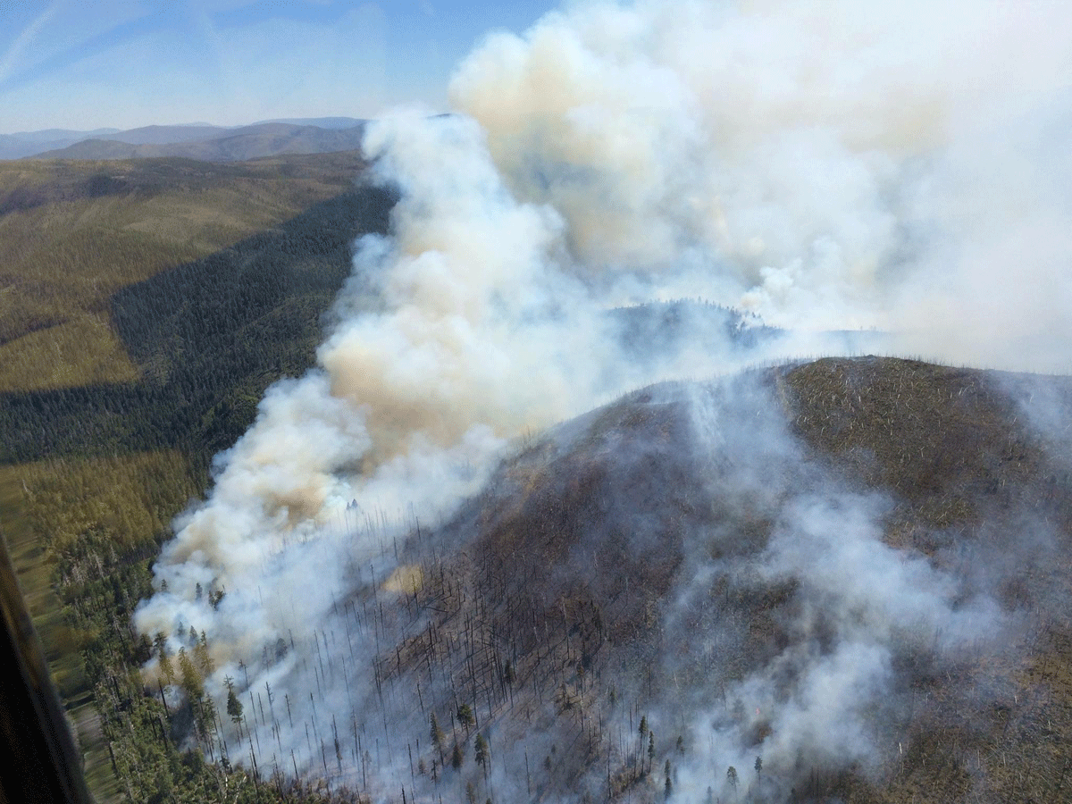
The Buckskin Fire (see photo), located in Curry county, approximately one mile SE of the Kalmiopsis Wilderness and six miles north of the California border, is approximately 100 acres in size. Due to safety issues with fire behavior, terrain, weather and many snags from the Biscuit Fire scar, hand crews did not engage on the fire yesterday evening. Aircraft water delivery was not effective due to winds.
Today, the Rogue River, Wolf Creek, Winema, Redmond and Prineville Hotshots, all 20-person highly trained initial attack crews, will be assigned to the Buckskin Fire. Two heavy helicopters are assigned to the fire and one air tanker is available at the Medford Airtanker Base. Two additional heavy helicopters and two medium helicopters with “helitack” support crews have been ordered. The Buckskin Fire is located approximately 10 miles SW of Cave Junction.
The Red Dog Fire located five miles SW of Onion Mountain on the Wild Rivers Ranger District, is 100% contained and mopped up and in patrol status.
Fire #367 (Little Onion) Fire is located two miles SE of Galice in Josephine County on the Wild Rivers Ranger District. The fire is currently four acres in size with a hand line completed around the perimeter of the fire. The fire is still active with a 20-person initial attack hand crew and miscellaneous overhead assigned.
Gold Beach Ranger District
The “Tom Fry” Fire (#355), located two miles SW of Agness, is four acres in size. The retardant line held yesterday and firefighters have completed containment line. Steep, rugged, and remote terrain, coupled with heavy fuel loading, is requiring an extended mop-up effort.
Fire #346 is located near Hog Mountain. The fire is 2 acres in size and firefighters have completed a line around it. Fire is in patrol status with one engine assigned.
#372 Miller Fire is 3.5 acres in size and is active but has not grown is size. Two engines, patrol unit, and 20-person initial attack hand crew are assigned. The fire is located near Elko Camp in the Hunter Creek area, is not threatening any structures, and is proximal to but not threatening South Coast Timber lands.
The North Smith Fire near Packsaddle Mountain is currently two acres in size. It is located near the SW corner of the Kalmiopsis Wilderness boundary. Four helitack crew members (Lakeview), and a Forest Service engine are assigned. This fire is contained and mop up efforts continue.
High Cascades Ranger District
Fire #362 (Cowboy Fire) is located one mile E of Robinson Butte on the High Cascade Ranger District. This fire is 1/10 of an acre in size and is contained, controlled and in patrol status.
For current recorded fire regulations, precautions, Industrial Fire Precaution Level (IFPL), and closure information 24 hours a day, call 800-267-3126
For additional fire and weather information, go to the Rogue River-Siskiyou National Forest website at http://www.fs.usda.gov/rogue-siskiyou or the Medford Interagency Dispatch Center at http://ormic.org/ or follow us on Twitter @RRSNF and the Oregon Department of Forestry’s blog swofire.com