June 16, 2015
A Public Meeting to provide information on the Buckskin Fire is planned for tonight in Cave Junction @ 6:00 p.m. at the Community Building on Highway 199.
The
Buckskin Fire, which is burning on the
Rogue River-Siskiyou National Forest, had little growth yesterday as the marine onshore flow moderated fire behavior due to lower relative humidity and temperature. The fire, burning in the old fire scar of the 2002 Biscuit Fire, is now an estimated 2,220 acres. Smoke production was down significantly with the smoke concentrated in the Illinois Valley. The area burned by the fire’s movement to the east on Sunday was considerably cooler yesterday producing less smoke.
Fire crews have made excellent progress building indirect fireline along the eastern flank from Buckskin Peak towards the Kalmiopsis Wilderness by utilizing Trail 1210.2. Crews will continue working today along this flank in preparation for potential burnout on Thursday. When locating firelines, firefighters take advantage of previous suppression lines, trails, and roads to confine the fire without always needing to construct line in undisturbed areas. Dozers will also continue improving Forest Road 112 (by removing snags and slides) along the eastern flank toward Buckskin Peak for a fire access road and indirect containment line.
Dozers and other heavy equipment (i.e. Feller bunchers, excavators, and skidgines) will continue working along the southern area of the fire (Forest Road 494) to provide better access and to establish the containment line for burnout. Fire potential spread remains high in this area considering fuels, topography, and anticipated winds. Fireline work in this area is nearing completion.
In preparation for the planned burnout, air tankers will be deployed on Wednesday to pre-treat with retardant the east containment line outside of the Wilderness.
Fire behavior on the western flank has been minimal due to sparse fuels. However, fire crews will continue work on a contingency line along the west (utilizing Trail 1233) and northwest sides of the fire should fire behavior increase in those areas.
Firefighters continued yesterday to make good progress on their effort to contain several spot fires located southwest of the main fire (the largest of those spots is about 90 acres). Hand crews used a combination of water delivery and helicopter water drops to contain the spots. Today crews will begin working to suppress the spot fires closer to the main body of the fire.
Communities in the Illinois and Rogue Valleys may continue to be impacted by smoke to varying degrees due to shifting winds, which are expected to persist for the next several days. Detailed air quality information can be found on Oregon Smoke Information at
http://OregonSmoke.BlogSpot.com.
The Rogue River-Siskiyou National Forest managers, working with fire management officials, has issued a Fire Area Closure Order closing public access to forest land surrounding the fire for public safety. The Order, in its entirety, can be viewed on the Buckskin Fire Inciweb site (see web address above) and Buckskin Fire Facebook web pages.
Natural resources at risk from the Buckskin Fire include: critical Coho Salmon habitat, Northern Spotted Owl habitat, Marbled Murrelet habitat and wilderness values. Resource advisors, such as botanists, fish and wildlife biologists and archaeologists, work with operations’ planners daily to provide options for suppressing the fire while being sensitive to the resources.
Temporary Flight Restrictions (TFR): TFRs are in place over the Buckskin Fire. Please check the NOTAMs for current information.
Start Date – June 11, 2015
Location – The wildfire is burning on the Rogue River-Siskiyou National Forest 10 miles southwest of Cave Junction.
Cause – Lightning
Resources – Crews – 12; Dozers – 7; Engines – 5; Water Tenders – 11; Helicopters – 10
Total Personnel – 496
June 13, 2015
High temperatures, low humidity, and gusty winds have driven the Buckskin Fire near Cave Junction to 1,200 acres. A Red Flag Warning remains in effect.
Firefighters are working to suppress the blaze that is actively burning and clearly visible from the town of Cave Junction. The fire behavior exhibited moderate runs to the southwest and into the old burn scar of the 2002 Biscuit Fire.
The terrain is extremely steep and crowded with leftover snags (standing dead trees) from the Biscuit Fire, making it extremely hazardous for fire personnel. Incident personnel are currently analyzing options for conducting indirect fire suppression.
There are 145 personnel assigned to the incident and a Type 2 Incident Management Team will take command on June 13 at 6:00 a.m. The incident commander will be Doug Johnson. Five interagency hotshot crews, two Type 2 hand crews, and four aircraft are currently assigned to the incident.
June 12, 2015
The fire danger level will increase to “high” (yellow) on Saturday, June 13, in the Wild and Scenic section of the Rogue River between Grave Creek and the mouth of Watson Creek. The Wild and Scenic section of the river between Grave Creek and Marial is managed by the Bureau of Land Management and protected from fire by the Oregon Department of Forestry’s Southwest Oregon District. The section of the river from Marial downstream to Watson Creek is managed and protected from fire by the Rogue River-Siskiyou National Forest.
The following fire prevention restrictions are currently in effect:
- Smoking is prohibited while traveling, except in boats on the water, and on sand or gravel bars that lie between water and high water marks that are free of vegetation.
- All travelers are required to carry one shovel and a one-gallon or larger bucket.
- The use of fireworks is prohibited.
Starting Saturday, June 13, the following fire prevention restriction takes effect and is in addition to the restrictions currently in effect in the Wild and Scenic section of the Rogue River. It applies to open fires:
- Campfires, including cooking fires and warming fires, will be prohibited. Charcoal fires for cooking and built in raised fire pans, and portable cooking stoves using liquefied or bottled fuels, will be allowed on sand or gravel bars that lie between water and high water marks that are free of vegetation. Ashes must be hauled out.
For further information about fire restrictions in the Wild and Scenic Section of the Rogue River, contact:
- The Rogue River-Siskiyou National Forest, (541) 618-2200;
- The Oregon Department of Forestry, Grants Pass Unit, (541) 474-3152;
- The Smullin Visitor Center located at the Rand National Historic Site at (541) 479-3735.
June 12, 2015
The fire danger level on Oregon Department of Forestry-protected lands in Jackson and Josephine counties will increase to “high” (yellow) on Saturday, June 13. The Industrial Fire Precaution Level will remain at level 1 (one).
These regulations affect 1.8 million acres of state, private, county, city and Bureau of Land Management lands protected by ODF’s Southwest Oregon District.
Fire prevention regulations currently in effect, and which will remain in effect, include:
- No debris burning, including piles and debris burned in burn barrels;
- No fireworks use on forestlands;
- Exploding targets and tracer ammunition, or any bullet with a pyrotechnic charge in its base, are prohibited;
- No sky lanterns may be used in wildland and forestland areas.
Starting Saturday at 12:01 a.m., the following regulations will go into effect:
- Campfires will be allowed only in designated campgrounds. Portable stoves using liquefied or bottled fuels may be used in other locations;
- Motorized vehicles will be allowed only on improved roads;
- Chain saws may not be used between 1:00 p.m. and 8:00 p.m. During other hours, chain saw users must have an ax, a shovel and an 8-oz or larger fire extinguisher at the job site, and a fire watch is required for one hour after the saw is shut down;
- Mowing of dead or dry grass with power-driven equipment will not be allowed between 1:00 p.m. and 8:00 p.m. This restriction does not include mowing of green lawns, or equipment used for the commercial culture and harvest of agricultural crops;
- The cutting, grinding or welding of metal will not be allowed between 1:00 p.m. and 8:00 p.m. These activities will be allowed during other hours provided the work site is cleared of potentially flammable vegetation and other materials, and a water supply is at the job site;
- Smoking while traveling will be allowed only in enclosed vehicles on improved roads;
- Electric fence controllers must be approved by a nationally recognized testing laboratory, such as Underwriters Laboratories Inc., or be certified by the Department of Consumer and Business Services, and be installed and used in compliance with the fence controller’s instructions for fire safe operation.
For more information about the Oregon Department of Forestry’s public regulated use regulations, please call or visit the Southwest Oregon District unit office nearest to you:
- Medford Unit, 5286 Table Rock Rd., Central Point. (541) 664-3328
- Grants Pass Unit, 5375 Monument Dr., Grants Pass. (541) 474-3152
June 12, 2015
Ground and aerial firefighting resources continue to gear up to meet the increased fire activity in Southern Oregon. No structures are threatened by any of the active fires. Additional aerial resources are being ordered to support suppression efforts; air resources are currently operating out of the Merlin Helibase. An Incident Management Team is being ordered to manage the Buckskin Fire.

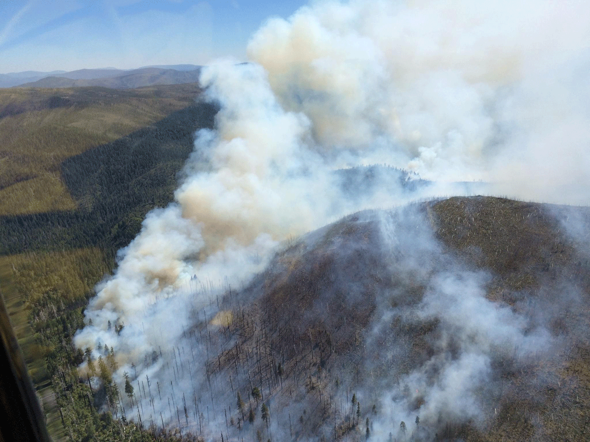
Wild Rivers Ranger District Fires
The Buckskin Fire (see photo), located in Curry county, approximately one mile SE of the Kalmiopsis Wilderness and six miles north of the California border, is approximately 100 acres in size. Due to safety issues with fire behavior, terrain, weather and many snags from the Biscuit Fire scar, hand crews did not engage on the fire yesterday evening. Aircraft water delivery was not effective due to winds.
Today, the Rogue River, Wolf Creek, Winema, Redmond and Prineville Hotshots, all 20-person highly trained initial attack crews, will be assigned to the Buckskin Fire. Two heavy helicopters are assigned to the fire and one air tanker is available at the Medford Airtanker Base. Two additional heavy helicopters and two medium helicopters with “helitack” support crews have been ordered. The Buckskin Fire is located approximately 10 miles SW of Cave Junction.
The Red Dog Fire located five miles SW of Onion Mountain on the Wild Rivers Ranger District, is 100% contained and mopped up and in patrol status.
Fire #367 (Little Onion) Fire is located two miles SE of Galice in Josephine County on the Wild Rivers Ranger District. The fire is currently four acres in size with a hand line completed around the perimeter of the fire. The fire is still active with a 20-person initial attack hand crew and miscellaneous overhead assigned.
Gold Beach Ranger District
The “Tom Fry” Fire (#355), located two miles SW of Agness, is four acres in size. The retardant line held yesterday and firefighters have completed containment line. Steep, rugged, and remote terrain, coupled with heavy fuel loading, is requiring an extended mop-up effort.
Fire #346 is located near Hog Mountain. The fire is 2 acres in size and firefighters have completed a line around it. Fire is in patrol status with one engine assigned.
#372 Miller Fire is 3.5 acres in size and is active but has not grown is size. Two engines, patrol unit, and 20-person initial attack hand crew are assigned. The fire is located near Elko Camp in the Hunter Creek area, is not threatening any structures, and is proximal to but not threatening South Coast Timber lands.
The North Smith Fire near Packsaddle Mountain is currently two acres in size. It is located near the SW corner of the Kalmiopsis Wilderness boundary. Four helitack crew members (Lakeview), and a Forest Service engine are assigned. This fire is contained and mop up efforts continue.
High Cascades Ranger District
Fire #362 (Cowboy Fire) is located one mile E of Robinson Butte on the High Cascade Ranger District. This fire is 1/10 of an acre in size and is contained, controlled and in patrol status.
For current recorded fire regulations, precautions, Industrial Fire Precaution Level (IFPL), and closure information 24 hours a day, call 800-267-3126
For additional fire and weather information, go to the Rogue River-Siskiyou National Forest website at http://www.fs.usda.gov/rogue-siskiyou or the Medford Interagency Dispatch Center at http://ormic.org/ or follow us on Twitter @RRSNF and the Oregon Department of Forestry’s blog swofire.com