August 31, 2016
Today firefighters walked the divisions of the Gold Canyon Fire allowing for a more accurate mapping of the perimeter. Crews used handheld GPS units to walk along the fire, now estimating it at 61 acres. The fire is 30 percent contained.
Residents on Wildpark Lane and Reeves Creek Road will remain at a Level 1 (Ready) Evacuation Level throughout the night. No structures have been lost.

Firefighters on the ground are facing steep terrain. While tomorrow’s temperatures are favorable throughout the morning, low relative humidity and variable wind gusts up to 20 mph could pose a challenge for firefighters on the line by the afternoon. Tonight firefighters will continue to extinguish hot spots and make sure fire lines remain secure.
The fire was reported Tuesday at 4:53 p.m. and its cause is under investigation. The Oregon Department of Forestry’s Southwest Oregon District is asking the public’s help in identifying the person or people who may be responsible for starting the Gold Canyon Fire.
Please call the Oregon Department of Forestry’s Grants Pass Unit office at (541) 471-3883 if you have information that will help identify people or vehicles in the area at that time. Information received will be confidential.
Fire management officials ask that the public continue to use caution and adhere to regulations. Current fire restrictions for lands in Jackson and Josephine Counties protected by the Oregon Department of Forestry Southwest Oregon District can be found at
www.swofire.com.
August 31, 2016
The Oregon Department of Forestry’s Southwest Oregon District is asking the public’s help in identifying the person or people who may be responsible for starting yesterday’s Gold Canyon Fire, which burned 120 acres of forestland south of Selma in Josephine County. The fire was reported at 4:53 p.m. Tuesday alongside Highway 199 (Redwood Highway) near the intersection with Gold Canyon Drive.
Please call the Oregon Department of Forestry’s Grants Pass Unit office at (541) 471-3883 if you have information that will help identify people or vehicles in the area at that time. Information received will be confidential.
August 31, 2016
Fire crews worked through the night building and strengthening fire line on the Gold Canyon Fire south of Selma. The fire is approximately 120 acres, 100 percent lined and 20 percent contained as of this morning.
The fire was reported Tuesday at 4:53 p.m. burning in steep terrain consisting of tall brush and timber. The cause is under investigation.
Weather conditions today call for temperatures in the mid 80s. While temperatures and relative humidity is favorable, there is a chance of variable winds reaching 5 mph.
This morning firefighters will continue to strengthen fire line, monitor fire activity for hot spots and mop up 50 feet within the line. Fire crews will also be walking the perimeter in order to get an accurate size of acres burned. Unless conditions change, we anticipate the fire size to be smaller than originally estimated from the air.
Today, residents on Wildpark Lane and Terrece Place will remain at a Level 2 (Set) Evacuation Level; residents on Reeves Creek Road will remain at a Level 1 (Ready) Evacuation Level, unless conditions change. The Rogue Valley Strike Team has been released, and the Illinois Valley Fire District will lead structural protection throughout the day.
An American Red Cross shelter has been set up at Rogue Community College in Grants Pass in the gymnasium for residents evacuated from the Gold Canyon Fire.
Redwood Highway is back open this morning. Please be cautious while driving through the fire area. There will be an increased presence of fire traffic along the road.
Fire management officials ask that the public continue to use caution and adhere to regulations. Current fire restrictions for lands in Jackson and Josephine Counties protected by the Oregon Department of Forestry Southwest Oregon District can be found at www.swofire.com.
August 30, 2016
Tonight firefighters will work to complete a fire line around the perimeter of the roughly 120-acre Gold Canyon Fire.
The fire burning south of Selma on ODF-protected lands is 85 percent lined and five percent contained.
Approximately 200 structures are threatened by the fire. However, no structures have been lost.
Residents on Wildpark Lane and Terrece Place are being reduced to a Level 2 (Set) Evacuation Level; residents on Reeves Creek Road are being reduced to a Level 1 (Ready) Evacuation Level, effective immediately.
An American Red Cross shelter has been set up at Rogue Community College in Grants Pass in the gymnasium for residents evacuated from the Gold Canyon Fire.
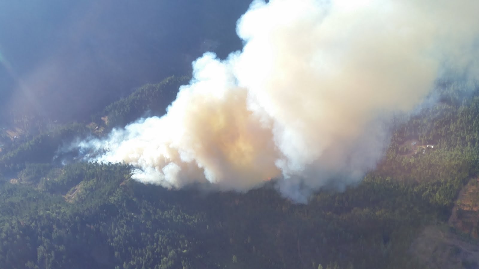
 |
| Gold Canyon Fire, photo courtesy of ODF ATGS Jesse Blair |
Air attack was an integral part of today’s firefight. Heavy air tankers and helicopters made numerous drops on the fire.
Firefighters on the ground are facing steep terrain. While tomorrow’s temperatures are favorable, there is still the chance of evening variable winds.
A structural protection strike team was activated to protect homes and other structures in the event the wildfire moved closer to homes. The team is assembled from engines and personnel from fire districts in Jackson and Josephine counties consisting of units from Jackson County Fire District #5 IAFF Local 2596, Jackson County Fire District 3, Medford Fire-Rescue, Jacksonville Fire, Ashland Fire-Rescue, Applegate Valley Fire, City of Grants Pass Fire, Illinois Valley Fire District, Rural Metro Fire Josephine County and Rogue River Fire. Some engines will remain in place throughout tonight.
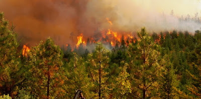 |
| Gold Canyon Fire, photo courtesy of IVFD Dale Sandberg |
By the morning, inmate crews and additional private contractors will be assisting with the fire.
The fire was reported today at 4:53 p.m. and its cause is under investigation.
Fire management officials ask that the public continue to use caution and adhere to regulations. Current fire restrictions for lands in Jackson and Josephine Counties protected by the Oregon Department of Forestry Southwest Oregon District can be found at www.swofire.com.
August 27, 2016
This is the final update about the Cleveland Ridge Fire unless conditions change.
The number of hot spots remaining inside the Cleveland Ridge Fire’s fire line is dwindling as burning vegetation either naturally burns out, or firefighters extinguish them. The day shift’s objective is to put out all hot spots within 300 feet of the fire line, and go farther when it is warranted.
The fire remains at 530 acres and is 80 percent contained. Today, 130 firefighters are working on the fire. Last night, 85 firefighters continued the mop-up operation and patrolled the fire perimeter.
The number of private contract firefighters assigned to the Cleveland Ridge Fire will continue to decrease this weekend until the final mop-up operation is turned over to seven 10-man crews from the Oregon Department of Corrections. They will be supported by a small fleet of wildland fire engines and water tenders, as well as fallers to cut down hazardous trees. An air tanker, helicopters and bulldozers will be available from the Oregon Department of Forestry’s Southwest Oregon District, based in Central Point.
The fire burned on private and Bureau of Land Management forestland 5 miles north/northwest of Shady Cove. Rehabilitation projects to protect the landscape against undue erosion and invasive plants will begin as mop-up operations decrease.
 Firefighters on the ground are facing steep terrain. While tomorrow’s temperatures are favorable throughout the morning, low relative humidity and variable wind gusts up to 20 mph could pose a challenge for firefighters on the line by the afternoon. Tonight firefighters will continue to extinguish hot spots and make sure fire lines remain secure.