August 25, 2016
The fire line around the 530-acre Cleveland Ridge Fire held today and firefighters turned to the task of mopping up remaining hot spots. The night shift crews will work toward completely extinguishing anything still burning within 100 feet of the fire line.
The fire is 50 percent contained.
More than 200 firefighters are working on the fire tonight. They have been counseled to watch for falling trees and rolling rocks, along with less-obvious hazards such as rattlesnakes, yellowjacket wasp nests and poison oak.
The fire began Monday afternoon below Cleveland Ridge, located on private and Bureau of Land Management forestland 5 miles north/northwest of Shady Cove.
TouVelle State Park in Central Point is closed to the public as the park is being used as the fire camp. Please avoid the area in order to allow fire traffic the accessibility they need to the entrance/exit points.
August 25, 2016
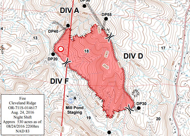
Firefighters were finally able to safely walk the perimeter of the Cleveland Ridge Fire last night allowing for a more accurate mapping of the fire. Until firefighters deem the perimeter safe, sizing estimates are made by aerial support. Crews used handheld GPS units to walk along the fire, now estimating it at 530 acres. Fire crews also strengthened fire line overnight, with some areas reaching 25 to 30 feet wide in order to prevent spot fires today.
The fire burning on private and Bureau of Land Management forestlands north/northwest of Shady Cove has a fire line completed around 100 percent of the fire and is 35 percent contained as of this morning.
The fire was reported at 4:01 p.m. Monday and started near the West Fork of Trail Creek Rd. The cause of the fire is under investigation.
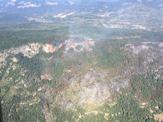
Air and ground support will work today to knock down the fire, continue strengthening control lines and work on mopping up hot spots along the perimeter. There will be a focus on the north side of the fire where the Cleveland Ridge Fire is most actively burning.
Weather conditions today could pose a challenge for firefighters. Temperatures are expected to range from 95-98 degrees, relative humidity between 10-12 percent, morning east/northeast winds at 3 mph with potential gusts up to 8 mph, and evening north/northwest winds at 3-5 mph with gusts up 8 mph. The fire is burning in grass, brush and mixed-age conifer forest. The topography ranges from moderate to very steep. Road access is good to the east and west flanks of the fire, and has increasingly improved on the north side.
The Level 1 (Be Ready) Evacuation Notice will remain in effect for residents on Taylor Rd. and the West Fork of Trail Creek Rd., as well as residents along Hwy. 227 from the junction with the West Fork of Trail Creek Rd. to address 6481 Hwy. 227. Firefighters will continue to monitor all structures surrounding the flanks of the fire throughout the day.
Sections of West Fork Trail Creek Road remain closed today. While all other roads are currently open, we ask that people are cautious while traveling through areas with high fire traffic.
As a reminder, TouVelle State Park in Central Point is closed to the public. The park is being used as the site for the Cleveland Ridge Fire fire camp. Please avoid the area in order to allow fire traffic the accessibility they need to the entrance/exit points.
Fire management officials ask that the public continue to use caution and adhere to regulations. Current fire restrictions for lands in Jackson and Josephine Counties protected by the Oregon Department of Forestry Southwest Oregon District can be found on the district’s Facebook page
ODF Southwest Oregon District and the website
www.swofire.com.
August 24, 2016
Firefighters are holding the Cleveland Ridge Fire at 635 acres. The fire burning on private and Bureau of Land Management forestlands north/northwest of Shady Cove has a fire line completed around 100 percent of the fire and is 25 percent contained as of tonight.
With the help of aerial support, day shift firefighters made significant progress on the north end of the fire. While the fire is still burning toward the north, night shift crews will continue to strengthen the fire line in order to prepare for the warm temperatures and high winds expected by tomorrow evening.
The Level 2 (Be Set) Evacuation Notice in place is being reduced to a Level 1 (Be Ready) Evacuation Notice for residents on Taylor Rd. and the West Fork of Trail Creek Rd., as well as residents along Hwy. 227 from the junction with the West Fork of Trail Creek Rd. to address 6481 Hwy. 227. We would like to thank all of the fire agencies in Jackson and Josephine Counties for their assistance with structural protection. Road blocks and closures on West Fork of Trail Creek Road are still in place as firefighters continue to work on the Cleveland Ridge Fire.
As a reminder, TouVelle State Park in Central Point is closed to the public. The park is being used as the site for the Cleveland Ridge Fire fire camp. Please avoid the area due to increased fire traffic, if possible.
The fire was reported at 4:01 p.m. Monday, and its cause is under investigation.
Fire management officials ask that the public continue to use caution and adhere to regulations. Current fire restrictions for lands in Jackson and Josephine Counties protected by the Oregon Department of Forestry Southwest Oregon District can be found on the district’s Facebook page at
ODF Southwest Oregon District, and www.swofire.com.August 23, 2016
A force of more than 200 firefighters worked throughout the day to relocate fire lines on the northeast and southeast flanks of the Cleveland Ridge Fire, burning on private and Bureau of Land Management forestlands north/northwest of Shady Cove. The fire grew along these flanks today but a wide bulldozer-constructed fire line along the spine of Cleveland Ridge held as the fire reached the ridgetop.
The fire has reached 574 acres in size and fire line has been completed around 80 percent of the fire.
The night shift crews, comprised of approximately 150 firefighters, will work to complete the fire line on the north flank and hold established fire lines around the rest of the perimeter.
Residents on Taylor Rd. and the West Fork of Trail Creek Rd. remain under a Level 2 (Set) Evacuation Level, which into effect at 8:00 a.m. today. Residents along Hwy. 227 from the junction with the West Fork of Trail Creek Rd. to address 6481 were also placed under the Level 2 alert. More than 40 structures are within the evacuation alert area.
A structural protection strike team stood by today to protect homes and other structures in the event the wildfire posed a threat. The team is assembled from engines and personnel from fire districts in Jackson and Josephine counties. They will remain in place throughout tonight.
Helicopters with water buckets flew throughout the day to cool spot fires and hot spots along the fire lines. (One of the helicopters made 105 bucket drops.) Air tankers made numerous retardant drops in areas where the fire either crossed or threaten to cross fire lines.
Much of the increased acreage today was due to the fire burning a large tract of forestland west of Cleveland Ridge. This area contains many steep, rocky bluffs and other rugged terrain that was too dangerous for firefighters to work in.
The fire was reported at 4:01 p.m. Monday, and its cause is under investigation.
August 23, 2016
A Level Two, “Be Set,” evacuation notice is in effect for homes along Tiller Trail Highway 227 from W. Fork Trail Creek Rd. through 6481 Tiller Trail Highway 227, as well as areas surrounding the fire along W. Fork Trail Creek Rd. No structures have been lost, but at least 40 are threatened.