August 13, 2016
Fire crews worked through the night cooling hot spots and monitoring fire lines on the Redwood Highway Fire in Selma. The cool and calm nighttime temperatures allowed for continued progress to be made on the line with 87 percent containment. The fire size remains at approximately 50 acres. The cause of the fire is under investigation.
Just before sunrise, firefighters discovered a 1/100th of an acre spot fire 1,000 feet outside of the current fire line. Within minutes, firefighters extinguished the flames and formed a wet line along the perimeter. Throughout the day, ground crews and air attack will continue to monitor the fire securing the perimeter and watching for snags, spotting, and flare ups. The goal is to ensure the fire perimeter is 100 percent lined by this evening.
Firefighters working on structural protection and prevention this morning uncovered three homes, and at least five outbuildings destroyed by the fire. It was originally thought by fire crews that only two homes were lost on Deer Creek Road; however, the daylight revealed that there were two homes on one property, a main house and guest house. All residents managed to safely evacuate. Firefighters will continue to search for additional structures damaged or threatened in the burned area.
Deer Creek Road remains under evacuation this morning. Residents on the 975 block and above on Deer Creek Rd. are at a “Be Set” Level 2 evacuation notice. Residents on the 974 block and below on Deer Creek Rd. remain at a “Go” Level 3 evacuation status. The road is closed to the public. After an additional assessment early this afternoon, Incident Command will revisit the option of reopening the road and changing evacuation levels. Residents seeking shelter assistance should visit the American Red Cross location in Cave Junction at 200 W. Watkins Street.
Redwood Highway is back open, but caution is advised. Firefighting operations are still occurring along the road and areas of smoke may be present.
The weather conditions today call for warm temperatures with variable wind gusts and low relative humidity. A fire weather watch will be in effect this afternoon beginning at 3 p.m. and ending at 8 p.m. We would like to thank all of the emergency agencies in Jackson and Josephine Counties that are assisting us and the public during this fire. We appreciate everyone’s quick response and collaboration.
The Oregon Department of Forestry Southwest Oregon District would like to remind the public that regulated use closures are in effect on ODF-protected lands in Jackson and Josephine Counties.
August 12, 2016
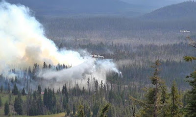
The first report of the Redwood Highway Fire in Selma came in at 3:34 p.m. Friday afternoon. At the time it was estimated at 1/10th of an acre in size with a consistent rate of growth burning in tall grass and dry brush on the west side of Redwood Highway. Within twenty minutes, the fire jumped the road and continued growing on the east side of Redwood Highway and up Deer Creek Road. The fire is now estimated to have grown to be between 50 to 75 acres with 85 percent dozer lined. We are working on an exact percentage of containment. The fire is under investigation.
Firefighters are currently working on holding the fire lines. Tree torching and spotting were initial issues firefighters on the ground were facing. Three Type 2 helicopters, a heavy helicopter, two air tankers, and one fixed-wing plane have been flying over the fire helping with cooling and suppression.
Residents on the 975 block and above on Deer Creek Road are at a Level 2 Evacuation. Homes on the 974 block and below on Deer Creek Road remain at a Level 3 Evacuation notice, along with all residents on Davis Creek Road. Four outbuildings and two homes were destroyed in the fire. The families of the two homes lost at 261 and 435 Deer Creek Road have been contacted. The American Red Cross is reaching out to help all families displaced by the Redwood Highway Fire at this time. All people originally evacuated to Boy Scout Camp near Lake Selmac are now being directed to the American Red Cross’ location at the United Methodist Church at 200 W. Watkins Street in Cave Junction. We are also setting up a community information center at the Red Cross shelter.
Deer Creek Road and Davis Road will remain closed at this time. Redwood Highway is back open.
Currently, crews from the Oregon Department of Forestry, Illinois Valley Fire District, Rural Metro Fire, Jackson County Fire District 5, Jackson County Fire District 3, Medford Fire-Rescue, Ashland Fire-Rescue, Applegate Valley Fire District, Oregon State Police, Josephine County Sheriff’s Office and Search & Rescue, Jackson County Emergency Management, Oregon Department of Transportation, Josephine County Public Works, American Medical Response, American Red Cross are all working together on different aspects of the fire response.
As always, we would like to remind the public that Fire Restrictions are in place on lands protected by the Oregon Department of Forestry in Jackson and Josephine Counties. For more on current fire regulations visit www.swofire.com.
Fire Information: (541)613-6313
August 9, 2016
Wildfires are often fast-spreading and unpredictable making it difficult for ground crews to navigate alone. This is why firefighting aircraft are an integral part of fire suppression.
However, aircraft cannot be used to fight fire if UAS (Unmanned Aircraft Systems), more commonly known as drones, are detected above or within a 5-mile radius of a wildfire. Both UAS and firefighting aircraft fly at low altitudes creating the potential for a mid-air collision which can injure or kill firefighters in the sky, crews on the ground, and the neighboring public.
This dangerous situation is why we ground all aircraft until UAS are removed from a wildfire. While aircraft is suspended, wildfires have the capacity to grow larger threatening more lives and property.
Please join ODF Southwest Oregon District in sharing our message: ‘If you fly, we can’t!’ Together, we can keep everyone in the air and on the ground safe allowing us to attack and suppress wildfires faster than if we worked alone.
Below is the link to our PSA and our Facebook page where the message is currently posted. Please share it on all platforms so that we may educate everyone on keeping drones away from wildfires.
ODF Southwest Oregon District YouTube:
https://www.youtube.com/watch?v=EeBkLTsBGts
ODF Southwest Oregon District Facebook:
https://www.facebook.com/ODFSouthwest/
August 5, 2016
Firefighters made great progress yesterday and were able to complete a strategic burnout on the northern flank of the Bybee Creek Fire, located in Crater Lake National Park. This firing operation will better secure the northern edge in case of high wind events and keep the fire south of Lightning Springs Trail.
Rim Village reported ash fallout yesterday afternoon. A predicted wind shift occurred, increasing fire activity on the northern flank. Fire activity did not increase closest to Rim Village.
An infrared flight occurred last night at 10 p.m. which showed the fire had grown to approximately 1,125 acres, and is 12 percent contained. This growth was primarily from firing operations that secured the already established control lines.
Increased fire activity with northwesterly winds is expected again today. Spotting and group torching will likely occur, followed by smoke and potential ash into Rim Village later in the afternoon.
Firefighters continue to monitor the small fire that is burning half way up the slope in the caldera. Less smoke was visible on the fire yesterday due to the lack of vegetation and pumice fields acting as natural barriers.
A structure protection group is in the area assessing threat to historical buildings which are in no immediate danger.
Nearly 380 personnel are assigned to the fire, along with 12 wildland fire engines, eight helicopters and two air tankers.
Fire danger continues to be high in the Crater Lake area with dry vegetation and changing weather. The public should be mindful of their surroundings and watch for updates.
Fire Restrictions: Crater Lake National Park implemented Stage Level 1 fire restrictions at midnight July 31, 2016. For more information visit: http://bit.ly/2b8gNfz
Level 1 Evacuation: Crater Lake National Park has issued a Level 1 Evacuation Notice for Rim Village and Park Headquarters until further notice. The Level 1 notice informs residents and visitors to “be ready” for a potential evacuation of Rim Village and Park Headquarters in the event that the Bybee Creek Fire approaches those areas. Mazama Village and other areas in the park are not affected by this Level 1 notice.
Closure: The Pacific Crest Trail is closed from Dutton Creek Camp north to the PCT parking lot on North Entrance Road. The Rim Trail is closed between Rim Village and North Junction. PCT hikers should use East Rim Drive as an alternate route. Lightning Springs Trail and backcountry camp are closed. The West Rim Drive from Rim Village to North Junction is temporarily closed.
August 3, 2016
The risk of wildfire is increasing across southwestern Oregon, and as a result, the Rogue River-Siskiyou National Forest is increasing the public use restrictions across much of the Forest.
“Southwest Oregon has experience several human-caused fires in the past few weeks. With the current fuels conditions, we feel it is important to implement public use restrictions to err on the side of caution,” says Eric Hensel, Fire Staff Officer for the Rogue River-Siskiyou National Forest. Effective 12:01 a.m. on August 5, 2016, the Rogue River-Siskiyou National Forest will impose public use restrictions that include limiting where open flames may occur, and areas where smoking or operating internal combustion engines is permissible.
Campfires must be built in Forest Service-constructed fire rings made of concrete or metal and located in designated recreation sites. With the exception of Sky Lakes Wilderness, wilderness areas within the Rogue River-Siskiyou National Forest are exempt from this restriction.
The use of propane or liquid fuel-powered commercial stoves is permitted. Smoking is allowed only while in vehicles, designated recreation sites, in areas clear of vegetation measuring at least 3 feet in diameter, or aboard watercraft on waterways. Welding or operating any other torch with an open flame is not allowed on Forest lands while these restrictions are in effect.
Operating an internal combustion engine is only permitted while in a vehicle on Forest Development Roads or within designated parking areas or while aboard a watercraft that is on water. Generators are allowed in designated recreation sites; please check with the Rogue River-Siskiyou National Forest before you camp to see if your destination is one of those designated sites. Additionally, internal combustion engine use is still permitted on the roads and trails at the Prospect OHV Trail System.
These public use restrictions will be effective until November 30, 2016, unless sooner rescinded.
The Industrial Fire Precaution Level will increase to IFPL 2 on the Wild Rivers, High Cascades, and Siskiyou Mountains Ranger Districts. Gold Beach and Powers Ranger Districts remain at IFPL 1.
Visitors to the Forest are encouraged to continue to be cautious with fire while in the woods. Forest officials remind recreationists to never abandon a campfire, and always ensuring that an extinguished campfire is cool to the touch.
For more information and to see the full text of the Forest Order, including a list of designated recreation sites where campfires are permitted, visit http://www.fs.usda.gov/alerts/rogue-siskiyou/alerts-notices.
