July 30, 2017
Today, firefighters walked the perimeter of the Burnt Peak Fire allowing for more accurate information to be gathered. Firefighters used GPS points from the ground to determine that the fire is 31 acres as of this afternoon. The fire is 30 percent contained. No evacuation orders have been issued; no structures were ever threatened by this fire.
Since the early hours of this morning, fire crews have been working to strengthen the control line around the perimeter. By the end of today’s day shift, firefighters mopped up 30 feet in from the fire’s edge. Although a quarter-acre spot fire was located southwest of the main body this morning, it was quickly knocked down and will be monitored through the upcoming days.
The Burnt Peak Fire located roughly 13 miles northeast of Shady Cove is burning in timber and debris on steep terrain on private property. The rugged landscape and gusty winds continue to challenge firefighters; however, the continuous coordination between ground and air attack assisted in today’s progress. One fixed-wing aircraft and three helicopters supported the fire today.
Tomorrow, firefighters will continue extensive mop up of the Burnt Peak Fire. With the triple-digit temperatures forecasted this week, crews are working to eliminate chances for flare ups. The fire was first reported Saturday around 6:15 p.m. and its cause is under investigation.
Fire management officials ask that the public continue to use caution and adhere to fire restrictions. Current regulations for lands in Jackson and Josephine Counties protected by the Oregon Department of Forestry Southwest Oregon District can be found at www.swofire.com.
July 30, 2017
At approximately 6:15 p.m., an Oregon Department of Forestry Southwest Oregon District reconnaissance aircraft was searching for a report of smoke in the area just north of Butte Falls. Air attack not only located the Olsen Fire which was knocked down at 1/10thof an acre, but also spotted a small, steady column building roughly 10-15 miles away. Immediately, multiple ODF Southwest engines, dozers, water tenders and two Type 2 helicopters were dispatched to the Burnt Peak Fire.
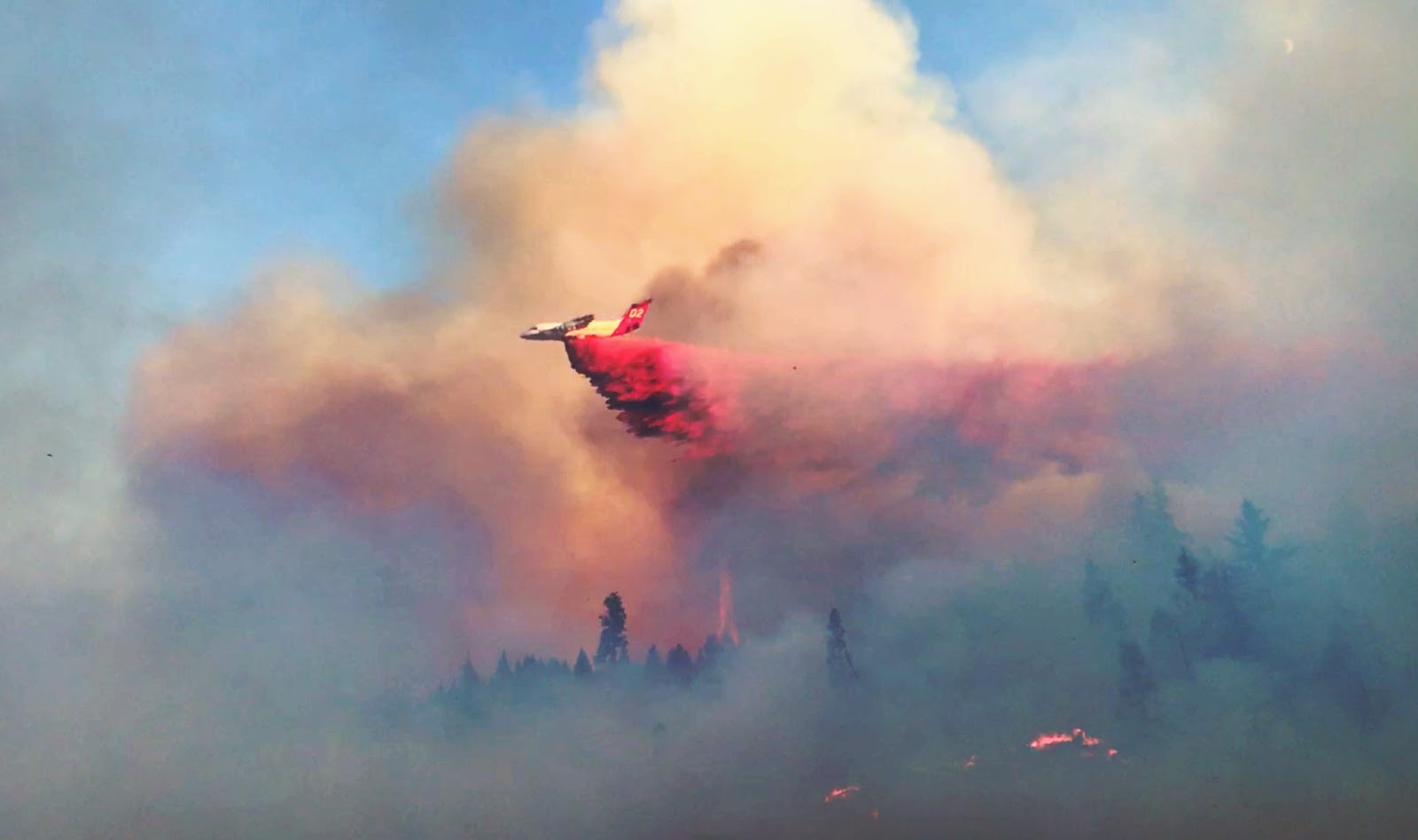
The initial size-up of the fire from the air was estimated to be 1-3 acres. The fire was quick moving, burning in steep terrain with wind shifts manipulating the direction of growth constantly. An additional Type 1 helicopter and two LATs (Large Air Tankers) were ordered to assist preliminary air operations. From 6:45 p.m. til 9:00 p.m., a total of five runs were made with the air tankers, which is equal to 15,000 gallons of retardant. Dozens of water drops were made collectively by the three helicopters. In order to continue using our air firefighting resources, a TFR (Temporary Flight Restriction) will be in effect beginning tomorrow at 6:00 a.m. For more information regarding the TFR over the Burnt Peak Fire as well as others in effect throughout the region, please visit www.tfr.faa.gov.
While air operations worked on the fire, ground resources were facing accessibility challenges due to steep slopes combined with limited road infrastructure. By the time the first engine engaged with the fire, the size was estimated at 20 acres. Crews worked on attacking the fire as aggressively and directly as possible; however, the wind shifts created a dangerous and difficult fire fight as spotting continued along the ridgeline. Firefighters were able to begin flanking the fire near sundown, but anticipate gusty winds throughout the night.
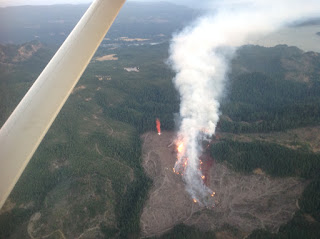
The Burnt Peak Fire, burning three air miles north of Lost Creek Lake, is estimated to be 60 acres as of 11 p.m. tonight. The cause of the fire is under investigation. There are no structures threatened; no evacuation notices have been issued. The closest structure is roughly three miles southwest of the fire along Elk Creek Road in Trail. There will be heavy fire traffic throughout the area. Please avoid the road, if possible.
Although no evacuation orders are in effect, it is a good time to make sure your family’s evacuation plan is refreshed and ready. To learn more about the state of Oregon’s three level evacuation process and how you can be prepared when wildfire strikes, visit the Rogue Valley Emergency Management page. The fire danger level throughout Jackson and Josephine Counties moves to ‘extreme’ Monday. For a reminder of what public fire restrictions will take effect, visit our Facebook page, ODF Southwest.
July 28, 2017
On Sunday, a grass fire off Interstate 5 and milepost 55 in Grants Pass was quickly knocked down at a half-acre; however, every firefighter on the ground and in the air faced an additional risk when a hobby drone was spotted in the sky.
The powerline-related fire was called in at roughly 4:10 p.m. Sunday, July 23rd. Within minutes, five engines, one water tender and one hand crew from the Oregon Department of Forestry Southwest Oregon District, one engine and one water tender from Rural Metro Fire Josephine County and two engines from Grants Pass Fire arrived on scene and began containing the fire. An ODF Southwest Oregon District, Type 2 helicopter, was dispatched shortly after to assist in the initial attack. Upon arrival, the helicopter was requested to perform a reconnaissance mission along the I-5 corridor in order to guarantee that the fire did not spot or spread to areas that firefighters on the ground could not see. With the water bucket deployed and already in tow, the helicopter headed south along I-5 searching for additional fire starts. The pilot had every intention of returning to the fire after the scouting mission; however, an ODF engine crewman spotted a drone heading toward the active fire scene just moments after the helicopter changed direction. The pilot was immediately contacted, left the area to create distance between himself and the drone, then landed safely at our Grants Pass headquarters. The Federal Aviation Administration (FAA) will be investigating the incident moving forward. ODF Southwest Oregon District would like to encourage anyone who sees a drone over an active fire incident to call 9-1-1.
“It jeopardizes the safety of our pilots, firefighters and the public. We are asking that people help spread this message so a drone interfering with firefighting operations does not happen again,” said ODF Southwest District Forester, Dave Larson.
As unmanned aircraft system (UAS) technology has become increasingly popular, so have run-ins between hobby drones and wildland firefighting agencies, like the Oregon Department of Forestry, that consider it a hindrance. This is the first time aerial operations have been grounded by a drone in the Southwest Oregon District. Thankfully, the pilot, firefighters and the public below were not harmed by the drone intrusion. Many people often forget that a single hobby drone is enough to take down firefighting aircraft.
When drones interfere with firefighting efforts, a wildfire has the potential to grow larger and cause more damage. Every second counts. Not to mention, every time an aircraft is grounded due to drone interference, thousands of dollars are wasted on take-off and landing alone. It is important to note that just because a helicopter is not visible in the sky, or flames are no longer noticeable on the ground, does not mean that fire scene is no longer ‘active.’ Aircraft are often orbiting a wildfire long after flames are knocked down. In addition, resources on the ground and in the air often revisit fire scenes in order to ensure there is no heat radiating from the ground that could potentially spark a new fire. As long as there are boots on the ground, the fire scene remains active.
Recreational drone use on a wildfire is prohibited by the FAA due to amount of risk in regards to human life. According to the FAA, “drone operators who interfere with wildfire suppression efforts are subject to civil penalties of up to $27,500 and possible criminal prosecution.” For further information about drone regulations, visit: www.knowbeforeyoufly.org.
Remember, if you fly, we can’t.
Please join ODF Southwest Oregon District in sharing our message on Facebookand YouTube. Together, we can keep everyone in the air and on the ground safe allowing us to attack and suppress wildfires faster than if we worked alone.
###
July 28, 2017
The fire danger level on lands protected by the Oregon Department of Forestry in Jackson and Josephine counties rises to “extreme” (red) at 12:01 a.m. Monday, July 31. This affects 1.8 million acres of state, private, county and Bureau of Land Management lands within ODF’s Southwest Oregon District.
The Industrial Fire Precaution Level (IFPL) will remain at Level 2 (two).
The primary difference between current fire prevention restrictions and those beginning Monday affects the public use of power-driven equipment, such as chain saws and mowers, to name a few. The use of power-driven equipment, grinding, cutting of metal, and other spark-emitting equipment, such as wood splitters and generators, will be prohibited.
Here are the details of the adjusted fire prevention regulations taking effect on July 31:
· The use of power saws is prohibited.
· The cutting, grinding and welding of metal is prohibited.
· The mowing of dry or dead grass is prohibited.
· The operation of any other spark-emitting internal combustion engine not specifically mentioned above is prohibited.
The following fire prevention regulations are currently in effect and will remain in effect until the fire danger level drops significantly:
· Smoking is prohibited while traveling, except in vehicles on improved roads, in boats on the water, and designated locations.
· Debris burning is prohibited.
· Burn barrel use is prohibited.
· Open fires are prohibited, including campfires, charcoal fires, cooking fires and warming fires, except in approved fire rings at designated campgrounds. In other locations, portable cooking stoves using liquefied or bottled fuels are allowed.
· Motor vehicles, including motorcycles and all-terrain vehicles, may only be used on improved roads free of flammable vegetation, except when used for the commercial culture and harvest of agricultural crops.
· Fireworks are prohibited.
· Any electric fence controller in use shall be listed by a nationally recognized testing laboratory or be certified by the Department of Consumer and Business Services; and operated in compliance with the manufacturer’s instructions.
· The use of exploding targets is prohibited.
· The use of tracer ammunition or any bullet with a pyrotechnic charge in its base is prohibited.
· Possession of the following firefighting equipment is required while traveling, except on state highways, county roads and driveways: one shovel and one gallon of water or one 2.5 pound or larger fire extinguisher. All-terrain vehicles and motorcycles must be equipped with one 2.5 pound or larger fire extinguisher.
July 21, 2017
Firefighters halted the North River Road Fire at 3.2 acres just around noon today. The initial report came in just before 10:30 a.m. with an estimated size of 1/100th of an acre. Within minutes, the fire spread upslope behind two homes off the 3800 block of N. River Rd in Gold Hill. While the two homes were initially threatened by the fire, no homes were lost or damaged by this incident.
While N. River Rd was closed temporarily due to fire traffic, the road is back open at this time. However, there are still several crews on site investigating the cause of the fire and mopping up hot spots along the hillside. Please use caution when driving through this area today.
Both ground and air efforts played a vital role in the quick containment of this fire. Our three helicopters made a combined total of 52 bucket drops over the fire. Visitors at Valley of the Rogue State Park witnessed firsthand how swiftly our air attack takes action as the helicopters dipped out of the Rogue River. Tanker 60 also made two retardant drops to help suppress the fire. For video of our firefighting efforts in action, visit our Facebook page: @ODFSouthwest.
Crews from the Oregon Department of Forestry’s Southwest Oregon District, Rogue River Fire District, Applegate Valley Fire District, Jackson County Fire District 3, Illinois Valley Fire District, Rural Metro Fire Josephine County assisted in the suppression of this fire. A special thanks to Oregon State Parks for helping block the road for fire traffic. As always, we would like to thank our partners for the continued quick and efficient responses to wildfires throughout our region.
Firefighters faced a quick-moving grass fire that was being wind-driven uphill. The fire’s behavior as it traveled rapidly through dense, dry brush is telling of how quickly are fuels throughout southern Oregon are losing moisture. Please keep in mind that the fire danger level on Oregon Department of Forestry protected lands in Jackson and Josephine counties will remain at “high” (yellow) for the time being. This means that our shut down time for several power-driven tools is from 10:00 a.m. to 8:00 p.m. For a full list of the public restrictions currently in place, check out our website: www.swofire.com.
For additional information about the Oregon Department of Forestry, please call or visit the Southwest Oregon District unit office nearest to you:
· Medford Unit, 5286 Table Rock Rd., Central Point. (541) 664-3328
· Grants Pass Unit, 5375 Monument Dr., Grants Pass. (541) 474-3152