July 16, 2018
QUICK FACTS
Incident Start Date: 7/15/2018
Incident Start Time: Approx. 9:00 a.m.
Incident Type: Wildfire
Cause: Lightning
Incident Location: Jackson & Josephine counties
Land Threat: Private, BLM, Industrial
Command Agency: ODF
Complex Size: 460 acres
Containment: 30%
Expected Full Containment: N/A
Civilian Injuries: 0
Firefighter Injuries: 0
Lightning Strikes: Approx. 1,000 across the District
Confirmed Wildfires: 65
Structures Threatened: 0
Structures Destroyed: 0
Structures Damaged: 0
CURRENT SITUATION
Garner Complex in Josephine County
Swamp Creek: 16 miles north of Rogue River. Estimated at 5 acres. Ground resources were able to complete a control line around the fire; however, snags are threatening the line. The fire is 20% contained. No structures threatened.
Little Grayback: 8 miles east of Cave Junction. Holding at 2 acres. Several ground resources were engaged today securing the perimeter. Smoke will continue to be present overnight and into tomorrow due to continued suppression efforts. No structures are threatened.
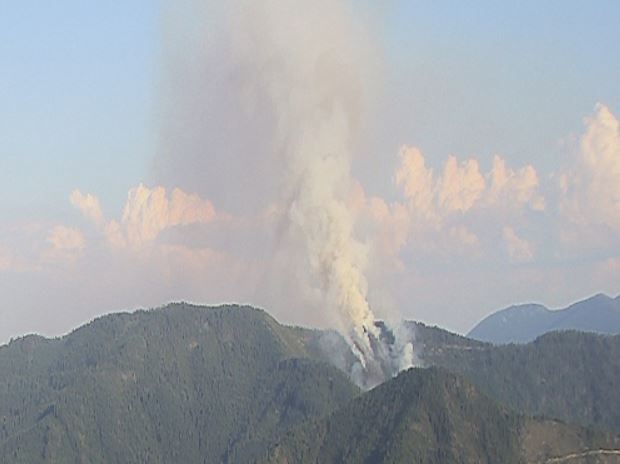
Spencer Creek Fires: Highly visible from Grants Pass, Applegate, Williams, Illinois Valley, and I-5. 12 miles south of Grants Pass. Approximately 3-5 fires in the area. Total fires estimated at 80 acres. Firefighters worked tirelessly on this series of fires. By the peak heat of the day, one of the fires made a significant push to the ridgetop. Overnight, several firefighters and heavy equipment will be focusing on securing the perimeter. No structures threatened.
Grave Creek Fires: Series of fires off Upper Grave Creek Road, visible from Wimer. Approximately 17 miles north of Rogue River. 6-7 fires in the area. Total fires estimated at 100 acres. Countless aerial resources were dedicated to this incident until sundown. The fire rapidly grew toward the end of shift near peak burning hours in triple digit temperatures. Overnight, crews will continue flanking the fire, working to achieve a controlled perimeter. No structures threatened.
Tennessee Mountain: 3 miles northwest of Cave Junction. Approximately 7 acres. Crews are close to completing control line around the fire. No structures threatened.
Fielder: North of MP 53 on I-5. Approximately 7 acres. Firefighters established a hose lay around the fire’s perimeter today. Overnight, firefighters will work on strengthening and securing the perimeter. No structures threatened.
The Oregon Department of Forestry Incident Management Team 2, led by Incident Commander Chris Cline, will be arriving tomorrow to take command of a series of fires within the Garner Complex. The local district, ODF Southwest, will remain command of the Wagner Creek Complex, as well as other additional fires as they pop up this week.
Wagner Creek Complex in Jackson County
Green Top Mountain: 5 miles northeast of Eagle Point. Holding at 125 acres. Roughly 90% of the perimeter control line is complete as the landscape has posed several challenges; however, the containment has boosted to 40%. Ground and aerial resources continued to fight this fire aggressively today, and are working on completing the perimeter’s control line overnight. No structures are threatened.
Sterling Creek: 7 miles south of Jacksonville. Holding at approximately 100 acres. Firefighters completed a control line around the entire perimeter of the fire today. The fire is 20% contained. Ground and aerial resources worked the fire all day. Level 3 “Go!” evacuations have been reduced to a Level 1 “Be Ready” evacuation notice. Rogue Valley structural units played an integral role involving home protection and defense. Fire crews will continue to knock down the interior perimeter of this fire overnight.
 Trail Creek & Elk Creek Drainage: Multiple fires are burning in the area surrounding Cleveland Ridge, Elk Creek, and the Trail Creek area which is roughly 5.5 miles north to northwest of Shady Cove. There are approximately 8 confirmed fires on ODF-protected land within the drainage. The largest fire in this area is estimated at 12 acres. Ground and aerial resources were engaged the entirety of today. Night shift ground resources will continue to knock down and work on control lines overnight. No structures are threatened.
There are several other fires in Jackson and Josephine Counties that we are working diligently to knock down and contain. Our air attack platform will be performing reconnaissance flights the entire day. Please know that all other ODF fires are an acre or less at this time, and are posing no threat to our communities.
Evacuations: No evacuations currently in place.
ASSIGNED RESOURCES
Engines: 25
Water Tenders: 6
Helicopters: 9
Hand Crews: 35
Dozers: 10
Total Personnel: 1,000 +
Air Tankers: 5
Cooperating Agencies: Oregon Department of Forestry, Bureau of Land Management, Rogue Valley Fire Chiefs Association, U.S. Forest Service Rogue River-Siskiyou
To learn more about wildfire preparedness & fire restrictions please visit: www.swofire.com
July 16, 2018
North Klamathon Update
Monday, July 16, 2018
Russell Wilstead, Incident Commander
|
Location: Approx. 4 mi. S of Greensprings, OR
Total Size Including Klamathon: 38,008 acres
Percent Contained: 95%
|
Start Date: July 5, 2018.
Cause: Under Investigation
Cost to Date Including Klamathon: $31,034,000
|
|
|
Type 1 Hand Crews
|
Type 2 Hand Crews
|
Engines
|
Type 1 Helicopters
|
Type 2 Helicopters
|
Type 3 Helicopters
|
Dozers
|
Total Personnel
|
|
0
|
3
|
10
|
0
|
0
|
1
|
1
|
156
|
To facilitate safe travel and provide close operational supervision, the portion of the Klamathon Fire in Oregon is now being managed as a separate fire. The Incident Command Post for the North Klamathon fire is at the Ashland Middle School in Ashland, Oregon.
Yesterday’s mission to retrieve equipment and repair fire lines was delayed because of widespread lightning that moved through southwest Oregon. Many resources assigned to the North Klamathon Fire including firefighters, engines, and helicopters were assigned to initial attack on multiple new starts. The resources remaining on the North Klamathon fire continued to patrol and mop-up along fire lines. The projected containment date has been extended one day, with full containment expected today.
Today seven engines, a water tender and three hand crews will remain available for initial attack on new fires resulting from yesterday’s lightning. Three engines, one water tender, one dozer, two excavators, and three hand crews remain assigned to equipment retrieval and fire suppression repair on the North Klamathon fire. Fire suppression repair is a series of immediate post-fire actions taken to repair impacts to the land and minimize the potential for soil erosion and other issues that might arise from fire line construction. Fire suppression repair is ongoing on the fire’s southern perimeters and is beginning on the Oregon side in the Cascade-Siskiyou National Monument and the Soda Mountain Wilderness.
Today’s weather forecast calls for the beginning of a hotter, drier trend lasting into mid-week.
Trails and roads that connect to the Medford District Bureau of Land Management closure order area continue to be patrolled by law enforcement agencies. Road closures are in place near Pilot Rock, on the Buckhorn Springs Road, Soda Mountain Road, Baldy Creek Road, and Mill Creek Road. The Pacific Crest Trail is closed between Highway 99 and Highway 66.
Information about the North Klamathon Fire is available at 503-475-8009.
July 16, 2018
WAGNER CREEK & GARNER COMPLEX UPDATE
@swofire
@ODFSouthwest
QUICK FACTS
Incident Start Date: 7/15/2018
Incident Start Time: Approx. 9:00 a.m.
Incident Type: Wildfire
Cause: Lightning
Incident Location: Jackson & Josephine counties
Land Threat: Private, BLM
Command Agency: ODF
Complex Size: 275 acres
Containment: 30%
Expected Full Containment:
Civilian Injuries: 0
Firefighter Injuries: 0
Lightning Strikes: Approx. 1,000 across the District
Confirmed Wildfires: 55
Structures Threatened: 20+
Structures Destroyed: 0
Structures Damaged: 0
CURRENT SITUATION
Situation Summary:
Date: 7/16/2018 Time: 10:00 a.m.
Garner Complex in Josephine County
Swamp Creek: 16 miles north of Rogue River. Estimated at 3 acres. Ground and aerial resources are enagaged. No structures threatened.
Little Grayback: 8 miles east of Cave Junction. Estimated at 2 acres. Several ground resources engaged, securing the perimeter. Smoke will be present. No structures threatened.
Spencer Creek #3: Highly visible from Grants Pass – Illinois Valley, 12 miles south of Grants Pass. Estimated at
10 acres. Ground and aerial resources are engaged. No structures threatened.
Wagner Creek Complex in Jackson County
Green Top Mountain: 5 miles northeast of Eagle Point. Estimated at 125 acres. Roughly 90% of the perimeter control line is complete, 5% contained. There was a roughly 4 acre spot fire this morning that has already been knocked down and brought back into the main body of the fire. Ground and aerial resources
are engaged. No structures are threatened.
Sterling Creek: 7 miles south of Jacksonville. Estimated at 100 acres. Roughly 55% of the perimeter control line is complete. Ground and aerial resources engaged. Level 3 “Go!” evacuations are in place impacting the even number addresses only off the 7400-9400 blocks of Sterling Creek Road. Rogue Valley structural units
are working on home protection and defense.
Wagner Creek Area: Highly visible off I-5. Please contact U.S. Forest Service, Rogue River-Siskiyou National Forest for additional details as it is burning on federal land; ODF is not engaged.
Trail Creek & Elk Creek Drainage: Multiple fires are burning in the area surrounding Cleveland Ridge, Elk Creek, and the Trail Creek area which is roughly 5.5 miles north to northwest of Shady Cove. The largest fire in this area is estimated at 10 acres. Ground and aerial resources are engaged. No structures are threatened.
There are several other fires in Jackson and Josephine Counties that we are working diligently to knock down and contain. Our air attack platform will be performing reconnaissance flights the entire day. Please know that all other ODF fires are an acre or less at this time, and are posing no threat to our communities.
 Trail Creek & Elk Creek Drainage: Multiple fires are burning in the area surrounding Cleveland Ridge, Elk Creek, and the Trail Creek area which is roughly 5.5 miles north to northwest of Shady Cove. There are approximately 8 confirmed fires on ODF-protected land within the drainage. The largest fire in this area is estimated at 12 acres. Ground and aerial resources were engaged the entirety of today. Night shift ground resources will continue to knock down and work on control lines overnight. No structures are threatened.