June 22, 2015
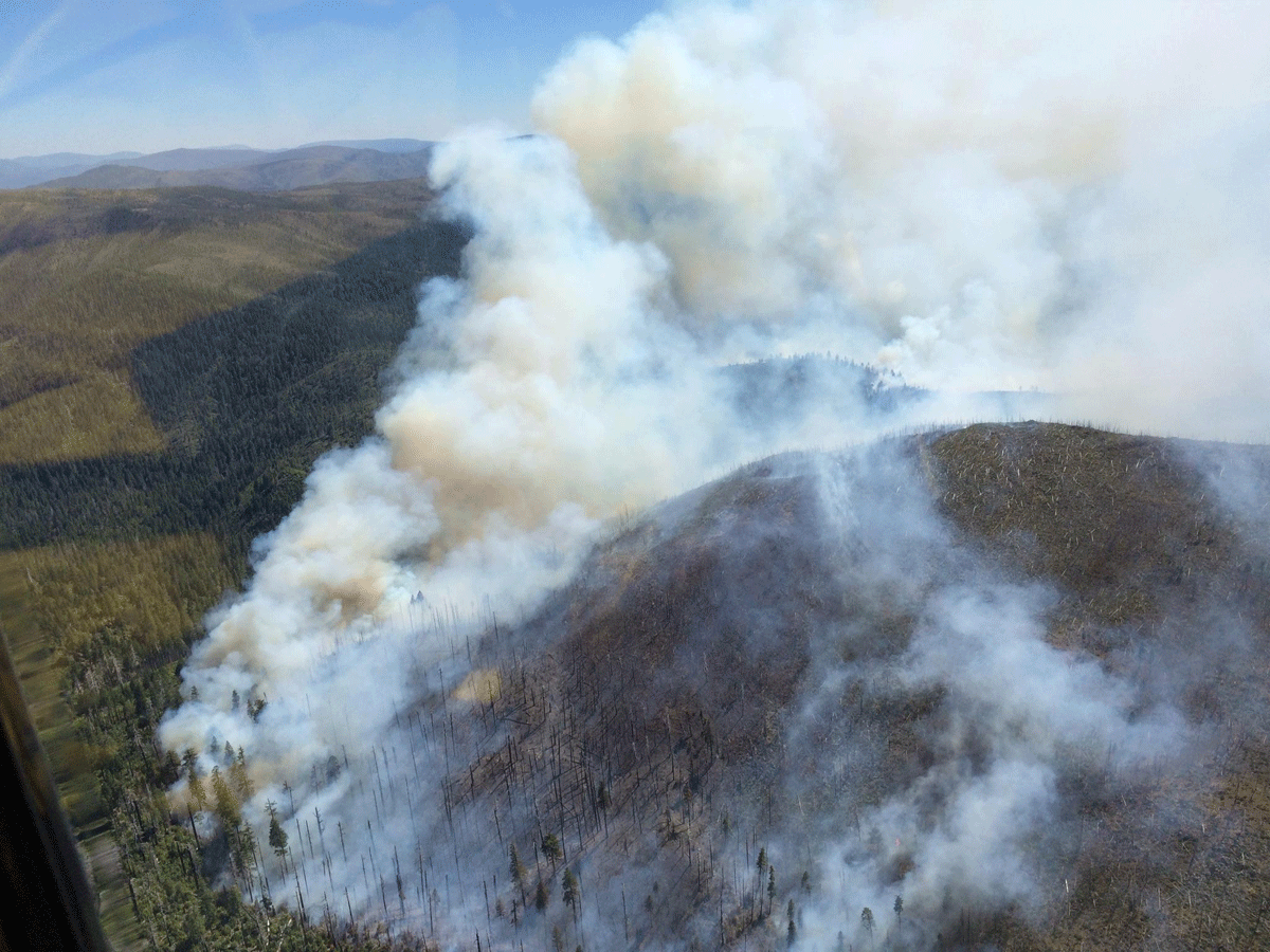
Fire crews progressed yesterday with their burnout along the southern flank of the 4,843 acre Buckskin Fire. This controlled burning operation combined with the main fire consuming unburned pockets of vegetation increased the amount of smoke in the area. The fire is now 30% contained. Fire officials expect the burnout to be completed within the next two days before local temperatures rise back above normal levels.
Firefighters also completed a containment line in their effort to secure the southwest corner of the fire near Baldface Creek. Crews implemented a combination of indirect line and natural barriers to locate the fireline and also cut a helispot for support and safety concerns. Burnout operations will be focused in this area today.
The eastern and portions of the southern flanks of the fire are now being mopped up as firefighters continue to extinguish burning material within 300 feet of the containment lines. Danger from snags, fire-weakened trees and steep terrain will determine the depth of the mop-up. Two 10-person fire crews will continue to monitor fire behavior and weather on the west flank.
A significant warming and drying trend is forecasted for the area with poor overnight humidity recovery and temperatures greater than 100 degrees by the end of this week.
Two heliwells (self-contained water tanks used for helicopter bucket operations) will be operational today to reduce the strain on waterways used as helicopter dip sites. Water treated with a small percentage of bleach is being used to mitigate the spread of Port Orford Cedar root rot disease.
Fireline repair will continue along the eastern perimeter as conditions allow. Resource advisors worked with Rogue River – Siskiyou National Forest specialists to prepare suppression repair guidelines that address suppression impacts.
The plan includes the repair of all dozer lines, trails, containment lines, spike camps and other fire suppression related activities. Primary fire lines will remain in place to assure containment until local officials deem it safe to complete suppression repair. Safeguards remain in place to reduce impacts to natural resources, including critical Coho salmon habitat.
Communities in the Illinois and Rogue Valleys may continue to be impacted by smoke until burnout is completed over the next several days. Those sensitive to smoke should be aware and take appropriate actions. Detailed air quality information can be found on Oregon Smoke at http://OregonSmoke.BlogSpot.com.
A Fire Area Closure Order remains in place closing forest land around the wildfire area to provide for public health and safety. For more information, please see the Rogue River-Siskiyou National Forest, Buckskin Fire Inciweb, or Buckskin Fire Facebook web pages.
Temporary Flight Restriction (TFR): A TFR remains in place over the Buckskin Fire. Please check the NOTAMs for current information.
Start Date – June 11, 2015
Location – 10 miles southwest of Cave Junction on the Rogue River-Siskiyou National Forest.
Cause – Lightning
Resources – Crews – 10; Dozers – 3; Engines – 6; Water Tenders – 10; Helicopters – 11
Total Personnel – 540
June 19, 2015
Firefighters initiated a burnout operation in the northeast section of the Buckskin Fire in their effort to contain the wildfire, which is now 2,635 acres and six percent contained. Ground personnel used drip torches to carry fire along the indirect containment line to just south of Buckskin Peak. A helicopter utilized a helitorch, an ignition device suspended beneath a helicopter, to ignite and consume fuels between the fireline and the main body of the fire.
The burnout progressed slowly due to strong westerly winds that blew embers across the containment line, challenging crews assigned to keep the fire within the containment lines. With the helicopter support, firefighters worked hard and kept the burnout in check.
Today, crews will continue bringing fire south by utilizing drip torches to provide a buffer and a helitorch to add depth to the burnout. This operation will likely last several days and increase the amount of smoke affecting nearby communities.
The fire continues to grow toward the south and east, but well within the containment lines. Crews continued to bolster the containment lines in this area. The wildfire exhibited minimal fire behavior along the western edge, where a contingency line is in place to provide a safeguard in the event fire activity increases in this area.Two 10-person fire crews remain on the west flank to monitor fire behavior and take suppression actions if necessary.
The 90-acre spot fire southwest of the main fire has been contained and will be monitored by aerial patrol.
Several plant and animal species remain at risk from the Buckskin Fire and deliberate measures are being taken to protect these natural resources.
Communities in the Illinois and Rogue Valleys may continue to be impacted by smoke.Those sensitive to smoke should be aware and take appropriate actions. Detailed air quality information can be found on Oregon Smoke at http://OregonSmoke.BlogSpot.com.
A Fire Area Closure Order remains in place closing forest land around the wildfire area to provide for public health and safety. For more information, log onto the Buckskin Fire Inciwebsite or Buckskin Fire Facebook pages.
Temporary Flight Restriction (TFR): A TFR remains in place over the Buckskin Fire. Please check the NOTAMs for current information.
Start Date – June 11, 2015
Location – 10 miles southwest of Cave Junction on the Rogue River-Siskiyou National Forest.
Cause – Lightning
Resources – Crews – 12; Dozers – 7; Engines – 6; Water Tenders – 13; Helicopters – 11
Total Personnel – 581
June 18, 2015
With slightly moderating temperatures and winds, increased relative humidity, and no recent adverse weather events, firefighting efforts are making great progress wrapping up most of the Forest’s local fires from lightning activity earlier this month.
Many resources are being released across the forest from all but the Buckskin Fire. Six crews have been released over the past 24 hours with another being de-mobbed tomorrow from Gold Beach. One local Type II crew and one Type 6 Engine will remain stationed at the Forest Service Agness Guard Station in Agness, OR, east of Gold Beach.
One VLAT (very large air tanker) and one LAT (large air tanker) have been operational today on the Buckskin Fire, in preparation for the planned burnout tomorrow, pre-treating (with retardant) the east and south containment lines outside of the Wilderness.
Residents and visitors were likely to have seen an increased amount of air activity today from these efforts.
No structures to date have been threatened by any of the fires.
Wild Rivers Ranger District
The Buckskin Fire, located in Curry County, is approximately 2360 acres in size. There is currently an area closure in place. For more information on the closure, please visit http://www.fs.usda.gov/alerts/rogue-siskiyou/alerts-notices. For more information on the Buckskin Fire, please visit Inciweb http://inciweb.nwcg.gov/state/38/.
Red Dog Fire located five miles SW of Onion Mountain has been 100% contained at 12.1 acres, and mopped up and in patrol status.
Little Onion Fire is located two miles SE of Galice in Josephine County on the Wild Rivers Ranger District. This fire has been 100% contained at 3.75 acres, mopped up and also in patrol status.
Limpy Creek Fire at .1 acre has been declared out.
Gold Beach Ranger District
The Tom Fry, Hog Mountain, and North Smith Fires have all been declared out at 3.75 acres, 1.5 acres, and 1 acre respectively. Periodic patrols continue.
The Miller Fire at 7.4 acres in size has been 100% contained. Crews continue to mop up and patrol.
High Cascades Ranger District
The Cowboy Fire at .1 acre has been declared out.
Siskiyou Mountains Ranger District
The Yew Wood Fire contained at 2.59 acres is currently in patrol status.
The Widow Fire remains at .1 acre. This is an 8-foot diameter tree with high complexity, leaving it unable to be felled or blasted. The top has broken off and no visible fire remains in the tree. However, handline has been constructed around the predicted fall area, pumps are in place to support if needed, and patrols will continue.
For current recorded fire regulations, precautions, Industrial Fire Precaution Level (IFPL), and closure information 24 hours a day, call 800-267-3126.
There are no current weather watches or Red Flag Warnings for the area. For additional fire and weather information, please go to the Rogue River-Siskiyou National Forest website at http://www.fs.usda.gov/rogue-siskiyou or the Medford Interagency Dispatch Center at http://ormic.org/ or follow us on Twitter @RRSNF.
June 17, 2015
Fire Location: Rogue River-Siskiyou National Forest
Incident Commander: Doug Johnson
Information Center – 541-597-2223
Inciweb: http://inciweb.nwcg.gov/incident/4286/
Email: Buckskinfire2015@gmail.com
The Buckskin Fire has had little growth over the past few days. The fire is estimated at 2,360 acres and is burning in the old fire scar of the 2002 Biscuit Fire.
Excellent progress has been made since this past weekend in building indirect containment lines around the fire in preparation for burnout Thursday along the eastern and southern flanks. The greatest current potential threat from the fire, due to fuels and terrain alignment with wind patterns to the nearest communities in the Illinois Valley are along the eastern flank, thus the concerted suppression emphasis in this area. When locating firelines, crews have taken advantage of previous suppression lines, trails, and roads to confine the fire without always needing to construct line in undisturbed areas.
In preparation for the planned burnout tomorrow, air tankers will be deployed today to pre-treat (with retardant) the east and south containment lines outside of the Wilderness. Residents and visitors to the area may see an increased amount of air activity today from these efforts.
Fire behavior on the western flank continues to be minimal due to sparse fuels. However, fire crews will continue work on a contingency line along the west (utilizing Trail 1233) and northwest sides of the fire should fire behavior increase in those areas.
Firefighters successfully contained the largest of the spot fires southwest of the main fire. Rapellers and helitack crews continue to use helicopter water drops to contain the spots. Firefighters have also begun working the remaining spot fires closer to the main body of the fire.
A community meeting was held last night at the Josephine County Building in Cave Junction. Approximately 80 people attended to hear an update on the Buckskin Fire and ask questions to fire managers. It was emphasized that the overall objective is to suppress the Buckskin Fire even though the fire currently lies 6-8 miles west of the nearest communities in the Illinois Valley. Fuels in the area are extremely dry due to prolonged drought. Fuels and fire behavior exhibit conditions normally found in July and August. Other large fires are starting across the Western states and Alaska which will now need firefighters, air resources and equipment to manage those situations. Fire fighting resources will become difficult to obtain as the fire season moves forward. As a result, the risk of not aggressively suppressing the Buckskin Fire at this point in the fire season is considered too great a threat to the communities surrounding the fire.
Natural resources at risk from the Buckskin Fire include: critical Coho Salmon habitat, Northern Spotted Owl habitat, Marbled Murrelet habitat and wilderness values. Resource advisors, such as botanists, fish and wildlife biologists and archaeologists, work with the Incident Management Team 3 daily to provide options for suppressing the fire while being sensitive to the resources. A “weed wash station” has been set up to wash vehicles going out to the fire and when returning to camp to reduce the potential spread of invasive species to lands in and around the fire.
Communities in the Illinois and Rogue Valleys may continue to be impacted by smoke to varying degrees due to shifting winds, which are expected to persist for the next several days. Detailed air quality information can be found on Oregon Smoke Information at http://OregonSmoke.BlogSpot.com.
The Rogue River-Siskiyou National Forest has issued a Fire Area Closure Order closing public access to forest land surrounding the fire for public health and safety. The Order, in its entirety, can be viewed on the Buckskin Fire Inciweb site (see web address above) and Buckskin Fire Facebook web pages.
Temporary Flight Restriction (TFR): The TFR is in place over the Buckskin Fire. Please check the NOTAMs for current information.
Start Date – June 11, 2015
Location – The wildfire is burning on the Rogue River-Siskiyou National Forest 10 miles southwest of Cave Junction.
Cause – Lightning
Resources – Crews – 12; Dozers – 7; Engines – 5; Water Tenders – 13; Helicopters – 10
Total Personnel – 536
June 17, 2015
In the event of an emergency in your area, you may be asked to evacuate. It’s important to understand the different levels of evacuation and what they mean for you, your family, your pets and your home.
Be Ready: Level 1
Evacuation Plan:
- Make a plan, and be sure everyone in your family understands it.
- Assign tasks to each family member for what to do during Level 1 (Ready), Level 2 (Set) and Level 3
- (GO!) evacuations.
- Have an evacuation plan for your pets and livestock. If it isn’t safe for you, its not safe for them.
- Designate a meeting place – this could be a friend or family member’s house, or an evacuation shelter.
- Choose an out-of-the-area contact person to relay information about your welfare to family and friends and to keep your phone lines open.
House Preparation
- Make sure house numbers are visible from the street.
- Make sure driveways are wide enough for emergency vehicles to enter (10-12 feet wide).
- Prepare your defensible space.
- Emergency Kits – Keep them ready at all times in your home and vehicle.
- Include supplies for you and everyone who lives in your home or visits regularly.
- Include supplies for your pets.
- Include copies of important documents, phone contact lists, family photos, household inventory lists, and any portable valuables.
- Keep your vehicles filled with gas.
Be Set: Level 2
- Keep pets and livestock ready to go in case you need to evacuate in a hurry.
- Be sure to have your photo ID or something showing your current address in case you need to access an evacuated area.
- Monitor local television and radio stations for updates.
- Move propane BBQ appliances away from structures (during wildfires).
Go!: Level 3
- Leave house lights on and windows closed.
- Let your emergency contact and/or family members know where you are going.
June 16, 2015
A Public Meeting to provide information on the Buckskin Fire is planned for tonight in Cave Junction @ 6:00 p.m. at the Community Building on Highway 199.
The
Buckskin Fire, which is burning on the
Rogue River-Siskiyou National Forest, had little growth yesterday as the marine onshore flow moderated fire behavior due to lower relative humidity and temperature. The fire, burning in the old fire scar of the 2002 Biscuit Fire, is now an estimated 2,220 acres. Smoke production was down significantly with the smoke concentrated in the Illinois Valley. The area burned by the fire’s movement to the east on Sunday was considerably cooler yesterday producing less smoke.
Fire crews have made excellent progress building indirect fireline along the eastern flank from Buckskin Peak towards the Kalmiopsis Wilderness by utilizing Trail 1210.2. Crews will continue working today along this flank in preparation for potential burnout on Thursday. When locating firelines, firefighters take advantage of previous suppression lines, trails, and roads to confine the fire without always needing to construct line in undisturbed areas. Dozers will also continue improving Forest Road 112 (by removing snags and slides) along the eastern flank toward Buckskin Peak for a fire access road and indirect containment line.
Dozers and other heavy equipment (i.e. Feller bunchers, excavators, and skidgines) will continue working along the southern area of the fire (Forest Road 494) to provide better access and to establish the containment line for burnout. Fire potential spread remains high in this area considering fuels, topography, and anticipated winds. Fireline work in this area is nearing completion.
In preparation for the planned burnout, air tankers will be deployed on Wednesday to pre-treat with retardant the east containment line outside of the Wilderness.
Fire behavior on the western flank has been minimal due to sparse fuels. However, fire crews will continue work on a contingency line along the west (utilizing Trail 1233) and northwest sides of the fire should fire behavior increase in those areas.
Firefighters continued yesterday to make good progress on their effort to contain several spot fires located southwest of the main fire (the largest of those spots is about 90 acres). Hand crews used a combination of water delivery and helicopter water drops to contain the spots. Today crews will begin working to suppress the spot fires closer to the main body of the fire.
Communities in the Illinois and Rogue Valleys may continue to be impacted by smoke to varying degrees due to shifting winds, which are expected to persist for the next several days. Detailed air quality information can be found on Oregon Smoke Information at
http://OregonSmoke.BlogSpot.com.
The Rogue River-Siskiyou National Forest managers, working with fire management officials, has issued a Fire Area Closure Order closing public access to forest land surrounding the fire for public safety. The Order, in its entirety, can be viewed on the Buckskin Fire Inciweb site (see web address above) and Buckskin Fire Facebook web pages.
Natural resources at risk from the Buckskin Fire include: critical Coho Salmon habitat, Northern Spotted Owl habitat, Marbled Murrelet habitat and wilderness values. Resource advisors, such as botanists, fish and wildlife biologists and archaeologists, work with operations’ planners daily to provide options for suppressing the fire while being sensitive to the resources.
Temporary Flight Restrictions (TFR): TFRs are in place over the Buckskin Fire. Please check the NOTAMs for current information.
Start Date – June 11, 2015
Location – The wildfire is burning on the Rogue River-Siskiyou National Forest 10 miles southwest of Cave Junction.
Cause – Lightning
Resources – Crews – 12; Dozers – 7; Engines – 5; Water Tenders – 11; Helicopters – 10
Total Personnel – 496
June 13, 2015
High temperatures, low humidity, and gusty winds have driven the Buckskin Fire near Cave Junction to 1,200 acres. A Red Flag Warning remains in effect.
Firefighters are working to suppress the blaze that is actively burning and clearly visible from the town of Cave Junction. The fire behavior exhibited moderate runs to the southwest and into the old burn scar of the 2002 Biscuit Fire.
The terrain is extremely steep and crowded with leftover snags (standing dead trees) from the Biscuit Fire, making it extremely hazardous for fire personnel. Incident personnel are currently analyzing options for conducting indirect fire suppression.
There are 145 personnel assigned to the incident and a Type 2 Incident Management Team will take command on June 13 at 6:00 a.m. The incident commander will be Doug Johnson. Five interagency hotshot crews, two Type 2 hand crews, and four aircraft are currently assigned to the incident.
June 12, 2015
The fire danger level will increase to “high” (yellow) on Saturday, June 13, in the Wild and Scenic section of the Rogue River between Grave Creek and the mouth of Watson Creek. The Wild and Scenic section of the river between Grave Creek and Marial is managed by the Bureau of Land Management and protected from fire by the Oregon Department of Forestry’s Southwest Oregon District. The section of the river from Marial downstream to Watson Creek is managed and protected from fire by the Rogue River-Siskiyou National Forest.
The following fire prevention restrictions are currently in effect:
- Smoking is prohibited while traveling, except in boats on the water, and on sand or gravel bars that lie between water and high water marks that are free of vegetation.
- All travelers are required to carry one shovel and a one-gallon or larger bucket.
- The use of fireworks is prohibited.
Starting Saturday, June 13, the following fire prevention restriction takes effect and is in addition to the restrictions currently in effect in the Wild and Scenic section of the Rogue River. It applies to open fires:
- Campfires, including cooking fires and warming fires, will be prohibited. Charcoal fires for cooking and built in raised fire pans, and portable cooking stoves using liquefied or bottled fuels, will be allowed on sand or gravel bars that lie between water and high water marks that are free of vegetation. Ashes must be hauled out.
For further information about fire restrictions in the Wild and Scenic Section of the Rogue River, contact:
- The Rogue River-Siskiyou National Forest, (541) 618-2200;
- The Oregon Department of Forestry, Grants Pass Unit, (541) 474-3152;
- The Smullin Visitor Center located at the Rand National Historic Site at (541) 479-3735.
June 12, 2015
The fire danger level on Oregon Department of Forestry-protected lands in Jackson and Josephine counties will increase to “high” (yellow) on Saturday, June 13. The Industrial Fire Precaution Level will remain at level 1 (one).
These regulations affect 1.8 million acres of state, private, county, city and Bureau of Land Management lands protected by ODF’s Southwest Oregon District.
Fire prevention regulations currently in effect, and which will remain in effect, include:
- No debris burning, including piles and debris burned in burn barrels;
- No fireworks use on forestlands;
- Exploding targets and tracer ammunition, or any bullet with a pyrotechnic charge in its base, are prohibited;
- No sky lanterns may be used in wildland and forestland areas.
Starting Saturday at 12:01 a.m., the following regulations will go into effect:
- Campfires will be allowed only in designated campgrounds. Portable stoves using liquefied or bottled fuels may be used in other locations;
- Motorized vehicles will be allowed only on improved roads;
- Chain saws may not be used between 1:00 p.m. and 8:00 p.m. During other hours, chain saw users must have an ax, a shovel and an 8-oz or larger fire extinguisher at the job site, and a fire watch is required for one hour after the saw is shut down;
- Mowing of dead or dry grass with power-driven equipment will not be allowed between 1:00 p.m. and 8:00 p.m. This restriction does not include mowing of green lawns, or equipment used for the commercial culture and harvest of agricultural crops;
- The cutting, grinding or welding of metal will not be allowed between 1:00 p.m. and 8:00 p.m. These activities will be allowed during other hours provided the work site is cleared of potentially flammable vegetation and other materials, and a water supply is at the job site;
- Smoking while traveling will be allowed only in enclosed vehicles on improved roads;
- Electric fence controllers must be approved by a nationally recognized testing laboratory, such as Underwriters Laboratories Inc., or be certified by the Department of Consumer and Business Services, and be installed and used in compliance with the fence controller’s instructions for fire safe operation.
For more information about the Oregon Department of Forestry’s public regulated use regulations, please call or visit the Southwest Oregon District unit office nearest to you:
- Medford Unit, 5286 Table Rock Rd., Central Point. (541) 664-3328
- Grants Pass Unit, 5375 Monument Dr., Grants Pass. (541) 474-3152
June 12, 2015
Ground and aerial firefighting resources continue to gear up to meet the increased fire activity in Southern Oregon. No structures are threatened by any of the active fires. Additional aerial resources are being ordered to support suppression efforts; air resources are currently operating out of the Merlin Helibase. An Incident Management Team is being ordered to manage the Buckskin Fire.

Wild Rivers Ranger District Fires
The Buckskin Fire (see photo), located in Curry county, approximately one mile SE of the Kalmiopsis Wilderness and six miles north of the California border, is approximately 100 acres in size. Due to safety issues with fire behavior, terrain, weather and many snags from the Biscuit Fire scar, hand crews did not engage on the fire yesterday evening. Aircraft water delivery was not effective due to winds.
Today, the Rogue River, Wolf Creek, Winema, Redmond and Prineville Hotshots, all 20-person highly trained initial attack crews, will be assigned to the Buckskin Fire. Two heavy helicopters are assigned to the fire and one air tanker is available at the Medford Airtanker Base. Two additional heavy helicopters and two medium helicopters with “helitack” support crews have been ordered. The Buckskin Fire is located approximately 10 miles SW of Cave Junction.
The Red Dog Fire located five miles SW of Onion Mountain on the Wild Rivers Ranger District, is 100% contained and mopped up and in patrol status.
Fire #367 (Little Onion) Fire is located two miles SE of Galice in Josephine County on the Wild Rivers Ranger District. The fire is currently four acres in size with a hand line completed around the perimeter of the fire. The fire is still active with a 20-person initial attack hand crew and miscellaneous overhead assigned.
Gold Beach Ranger District
The “Tom Fry” Fire (#355), located two miles SW of Agness, is four acres in size. The retardant line held yesterday and firefighters have completed containment line. Steep, rugged, and remote terrain, coupled with heavy fuel loading, is requiring an extended mop-up effort.
Fire #346 is located near Hog Mountain. The fire is 2 acres in size and firefighters have completed a line around it. Fire is in patrol status with one engine assigned.
#372 Miller Fire is 3.5 acres in size and is active but has not grown is size. Two engines, patrol unit, and 20-person initial attack hand crew are assigned. The fire is located near Elko Camp in the Hunter Creek area, is not threatening any structures, and is proximal to but not threatening South Coast Timber lands.
The North Smith Fire near Packsaddle Mountain is currently two acres in size. It is located near the SW corner of the Kalmiopsis Wilderness boundary. Four helitack crew members (Lakeview), and a Forest Service engine are assigned. This fire is contained and mop up efforts continue.
High Cascades Ranger District
Fire #362 (Cowboy Fire) is located one mile E of Robinson Butte on the High Cascade Ranger District. This fire is 1/10 of an acre in size and is contained, controlled and in patrol status.
For current recorded fire regulations, precautions, Industrial Fire Precaution Level (IFPL), and closure information 24 hours a day, call 800-267-3126
For additional fire and weather information, go to the Rogue River-Siskiyou National Forest website at http://www.fs.usda.gov/rogue-siskiyou or the Medford Interagency Dispatch Center at http://ormic.org/ or follow us on Twitter @RRSNF and the Oregon Department of Forestry’s blog swofire.com
June 11, 2015
Firefighting resources are responding to the “Buckskin” Fire, located approximately six miles north of the California border approximately one mile outside the Kalmiopsis Wilderness on the Rogue River-Siskiyou National Forest.
Airtanker 161 is dropping water on the estimated 50-75 acre blaze which is actively burning and clearly visible from the town of Cave Junction.
Members of the Siskiyou Rappel crew are on the ground on-scene and more rappellers are en route. Helicopters are also en route/on scene, as are smokejumpers from Redmond. Two hotshot crews currently assigned to other incidents on the Rogue River-Siskiyou National Forest are being reassigned to the Buckskin Fire to help battle the blaze.
June 11, 2015
Firefighting crews and aerial resources continue to work on mop up efforts on several fires across the Rogue River-Siskiyou National Forest, in addition to responding to new starts on the Gold Beach Ranger District. Weather will be continued hot and dry conditions over the weekend with a slight chance of thunderstorms and no precipitation in the forecast for the next week.
Gold Beach Ranger District
The “Tom Fry” Fire (#355), located two miles SW of Agness, is four acres in size. The retardant line held yesterday and firefighters have completed containment line. Steep, rugged, and remote terrain, coupled with heavy fuel loading, is impacting mop up efforts.
Fire #346 is located near Hog Mountain. The fire is 2 acres in size and firefighters have completed a line around it. Fire is in patrol status with one engine assigned.
New Starts
#372 Miller Fire, called in this morning, is reported to be 3.5 acres in size. One Forest Service engine, patrol unit, and 20-person initial attack hand crew are responding, in addition to Coos Forest Protection Association resources. The fire is located near Elko Camp in the Hunter Creek area, is not threatening any structures, and is proximal to but not threatening South Coast Timber lands.
The North Smith Fire near Packsaddle Mountain is currently two acres in size. It is located near the SW corner of the Kalmiopsis Wilderness boundary. Four helitack crew members (Lakeview), a Forest engine and a 20-person initial attack hand crew is assigned.
Wild Rivers Ranger District
The Red Dog Fire located five miles SW of Onion Mountain on the Wild Rivers Ranger District, is 100% contained and mopped up. An assigned 20-person hand crew is pulling hose off the line today. After today, the fire will be in patrol status.
Fire #367 (Little Onion) Fire is located two miles SE of Galice in Josephine County on the Wild Rivers Ranger District. The fire is currently four acres in size with a hand line completed around the perimeter of the fire. Assigned resources include the Rogue River Interagency Hotshot Crew, the Prineville Hotshots, 3 rappelers, and an 8-person hand crew. Challenges include rolling material and competition with other incidents on forest for helicopter water bucket support.
High Cascades Ranger District
Fire #362 (Cowboy Fire) is located one mile E of Robinson Butte on the High Cascade Ranger District. This fire is 1/10 of an acre in size and is contained, controlled and in patrol status.
For current recorded fire regulations, precautions, Industrial Fire Precaution Level (IFPL), and closure information 24 hours a day, call 800-267-3126.
For additional fire and weather information, go to the Rogue River-Siskiyou National Forest website at http://www.fs.usda.gov/rogue-siskiyou or the Medford Interagency Dispatch Center at http://ormic.org/ or follow us on Twitter @RRSNF.
June 11, 2015
ODF engine crews from the Grants Pass Unit brought a halt to an 8-acre wildfire Wednesday afternoon along the edge of Interstate 5 near Milepost 68. Structural fire protection engines from Rural-Metro Fire Dept. pitched in with protecting homes and battling the wildfire. Traffic in I-5’s southbound lane crept past single-file as two helicopters, a bulldozer and numerous firefighters worked to bring the blaze under control. Crews remained on-scene until midnight, and have returned this morning to complete mop-up operations on the fire.
No injuries were reported and the cause of the fire is being investigated.
ODF Medford Unit firefighters continue to mop up the 46-acre Rosebud Fire and the 9-acre Little Butte Creek Fire, both of which were caused by lightning from thunderstorms on Tuesday morning. The other fires caused by the storm have been extinguished or continue to be mopped up, and crews will be checking all of the fires today.
Late Wednesday, a holdover lightning-caused fire was discovered on 9 Mile Peak, south of Ruch in the Applegate drainage. Firefighters from the ODF’s Medford Unit, with the aid of a helicopter, controlled the fire at 1/4 acre.
June 9, 2015
The thunderstorms early this morning started 16 fires on ODF’s Medford Unit and 5 fires on the Grants Pass Unit. The largest fires are:
- Rosebud, approx. 15 acres
- Left Fork Foots Creek, 5 acres
- South Fork Little Butte Creek, 4 acres
- Jump Off Joe Creek, 2 acres
- Wards Creek, 1 acre
The rest of the fires are 1 acre in size or smaller; most are smaller than 1/10th of an acre. The Rosebud Fire (photo below), located 5 miles south of Pinehurst in the Soda Mountain Wilderness, has had helicopters dropping water on it for most of the afternoon, and crews are working their way in by foot and by helicopter shuttle. No engine access.
The Left Fork Foots Creek Fire is burning in heavy fuel and helicopters have been dropping buckets of water onto hot spots for much of the afternoon. A bulldozer has been constructing fire line.
The South Fork Little Butte Creek Fire is also a walk-in fire, and helicopters with buckets have been supporting firefighters on the ground.
All of the fires 1 acre in size and smaller have been lined and the fires 1/10th of an acre and smaller have been 100 percent mopped up.
A reconnaissance plane has been flying the district all day and another flight is planned for Wednesday.
June 9, 2015
Firefighting resources have responded to a number of new lightning-caused fires across the Rogue River-Siskiyou National Forest today, and additional resources have been ordered to assist with continued response to new starts.
On the Gold Beach Ranger District, the “Tom Fry” Fire (#355), two initial attack crews initially responded to this fire. The fire has grown to 4 acres in size and short range spotting is occurring. A heavy helicopter and air tanker are currently assisting with firefighting efforts on the ground. A Forest Service engine, rappellers and Coos Forest Protective Association resources responded to Fire #346, located near Hog Mountain. The fire is 1.5 acres in size and firefighters have completed a line around it.
On the Wild Rivers Ranger District (Grants Pass/Cave Junction), Fire #358, in the Limpy Creek area, a fire 1/10 acre in size has been completely lined. This fire was staffed by a crew, one engine and additional resources from Oregon Department of Forestry.
The Red Dog Fire is expected to be 100% contained by end of shift this evening. The Winema Hotshots have been reassigned to the Siskiyou Mountains Ranger District in the Ashland/Applegate areas to support potential new starts.
Additional resources have been ordered to assist local firefighting resources with lightning-caused fire starts and have arrived on scene, or are en route:
- Prospect/Butte Falls: One 20-person veterans’ crew and a strike team of engines
- Gold Beach: Prineville Interagency Hotshots
- Grants Pass/Cave Junction: Wolf Creek Interagency Hotshots and one additional engine
- Ashland/Applegate: Redmond Interagency Hotshots
June 9, 2015
Sixteen lightning-caused fires have been found and staffed on lands protected by the Oregon Department of Forestry’s Southwest Oregon District. A dozen of the fires are on the Medford Unit and four on the Grants Pass Unit. Two of the fires were 1/2 acre in size and most of the others are 1/10th of an acre in size or smaller.
Firefighters and equipment are making their way into fires in the Jump Off Joe Creek area, north of Grants Pass; the Little Butte Creek area, east of White City; and in the Soda Mountain Wilderness, east of Ashland.
Three helicopters have been available to the firefighters for dropping water on hot spots. An airplane has also been flying all day, searching for smokes and assisting firefighters by providing fire location and access information.
June 9, 2015
Firefighting crews have made excellent progress suppressing the 12-acre Red Dog Fire, having created a strong containment line by late yesterday evening. A lightning-struck tree was identified as the cause of the fire. The fire is currently 50% contained and is expected to be fully contained at the end of shift this evening. Resources will continue to mop up the fire; if additional resources are needed for response to other priority incidents, crews may be reassigned. This includes the Rogue River Interagency Hotshot crew, the Winema Hotshots and a 20-person Grayback initial attack crew.
Last night, abundant dry lightning strikes occurred across SW Oregon with very little to no precipitation. In response, firefighting resources are pre-positioning for patrolling and response to new lightning-caused fire starts across the Rogue Rover-Siskiyou National Forest. A Red Flag Warning is in effect for abundant lightning activity through 11 p.m. tonight.
Increasing thunderstorm activity will create erratic fire behavior and new starts in Curry, Josephine, and Jackson Counties. Scattered thunderstorms this morning will start to diminish, then become scattered again this afternoon and evening. Gusty winds from 40-50 mph will be possible with the stronger thunderstorms. Some of the storms will produce moderate to heavy rainfall. Abundant lighting on existing very dry fuels could cause numerous fire ignitions. Gusty and erratic winds could also create explosive fire growth potential.
“We are aggressively pre-positioning our available firefighting resources for quick response to new fire starts,” said Dan Quinones, Deputy Fire Staff & Aviation Officer.
One new lightning-start has been detected on the Gold Beach Ranger District that is located on the border with Coos Forest Protection Lands. The new start is three miles SE of Three Tree Campground.
The Merlin Helibase has two medium helicopters, one rappel aircraft (John Day) and one helitack platform (Lakeview). Two fixed wing aircraft are available for aerial reconnaissance as of 0830 this morning. In addition, a heavy helicopter has been ordered from LaGrande.
In the Siskiyou Mountains, one engine is available for patrol and response. In addition, the Winema Hotshots are scheduled to be assigned to the area this afternoon after being released from the Red Dog Fire.
In the Prospect/Butte Falls area, in addition to the normal staffing of firefighting resources, a task force of engines and hand crews are pre-positioned for response. This includes 5 engines, one 20-person initial attack crew and several overhead leadership positions. Additional resources are being ordered.
In the Gold Beach area, a 15-person hand crew and engine is available for patrol/response, and in the Powers area, an engine and a prevention unit are also available, in addition to the increase air reconnaissance and air support that is being provided across the forest.
Firefighting resources will be moved and reassigned across the forest as new starts are detected and priorities change, utilizing information from lightning strike detection maps, aerial reconnaissance and smoke reports.
June 9, 2015
A widespread thunderstorm early this morning scattered lightning across Jackson and Josephine counties. ODF Medford Unit firefighters are working on five small fires in the Foots Creek and Galls Creek areas. The largest fire so far is 1/4-acre on Pikes Peak (T 37S, R 3W, Sec 6). ODF Grants Pass Unit engine crews are responding to reports of smoke in the Wards Creek, Cheney Creek, Birdseye Creek, Horesehead Creek and Fish Hatchery Road areas.
A reconnaissance flight is going aloft after 10:00 a.m. to detect other fires.
June 8, 2015
Power Equipment Use
Fire season in ODF’s Southwest Oregon District went into effect Friday, June 5, at which time open burning season ended. However, many people have called to find out about restrictions on power-driven machinery use (ie chain saws, mowers, brush cutters, etc.). At this time, there are no restrictions on the use of power equipment, so it is OK to use equipment to cut brush, grass and trees.
But it is a good idea to take some precautions when using power-driven equipment.
- Have water or a fire extinguisher and a shovel at your work site;
- Frequently check the area you’ve worked in to make sure a spark hasn’t kindled a small fire;
- Continue to check your work area for at least one hour after you’ve shut down the equipment;
- If you do accidentally cause a fire, call 9-1-1 to report the fire and then use your water and shovel to try and extinguish the fire.
Red Dog Fire
The Red Dog Fire (photo above) is located on the Wild Rivers Ranger District of the Rogue River-Siskiyou National Forest in Josephine County. Fire activity is currently moderate, burning in brush, slash and timber in steep terrain. The fire is currently 10 acres in size, and started at approximately 9:30 p.m. on Saturday, June 6.
The Red Dog Fire is believed to be a lightning-caused start, possibly a “holdover” from a previous storm. A Type 3 Incident Commander (Aaron Schuh) has been assigned.
“Due to the unseasonably hot and dry conditions, coupled with low humidity, we quickly assigned local available firefighting resources,” said Deputy Fire & Aviation Staff Officer Rob Budge.
Resources on scene include the Rogue River Interagency Hotshots, the Winema Hotshots, a 5-person hand crew module, two 20-person initial attack contract crews, two Forest Service engines, and two helicopters. Firefighters have completed a “scratch line” around the fire and will continue to improve the line. Crews are optimistic the line will hold, although lightning is predicted on Tuesday.
The fire is located approximately five miles SW of Onion Mountain, one mile W of Horse Mountain and two miles E of the Kalmiopsis Wilderness boundary and 9 miles NW of Selma. Although there are mining claims in the area, no structures are threatened.
Due to the amount of fire traffic in the area, several road closures are anticipated to ensure firefighter and public safety.
Other Fire Activity in Southwest Oregon
A 7-acre fire broke out late Friday afternoon in the Abbott Prairie area (see photo), located 8 miles north of Lost Creek Reservoir. The fire is on private timberland and burned old logging slash. Today, a 10-man crew and two engines are mopping up remaining smokes. The cause is under investigation.
On Saturday, June 6, two fires caused by debris burning were extinguished in the Williams and Sunny Valley areas. The Williams-area fire burn 1/4 acre and the Sunny Valley-area fire burned 1/10th of an acre.
A structure fire near Rogue River on Sunday morning caused a 1/4-acre grass fire that was quickly extinguished. That same day, a 1 1/2-acre fire was extinguished along Pompadour Drive, east of Ashland. The cause of this fire in under investigation.