Ground and aerial firefighting resources continue to gear up to meet the increased fire activity in Southern Oregon. No structures are threatened by any of the active fires. Additional aerial resources are being ordered to support suppression efforts; air resources are currently operating out of the Merlin Helibase. An Incident Management Team is being ordered to manage the Buckskin Fire.
Wild Rivers Ranger District Fires
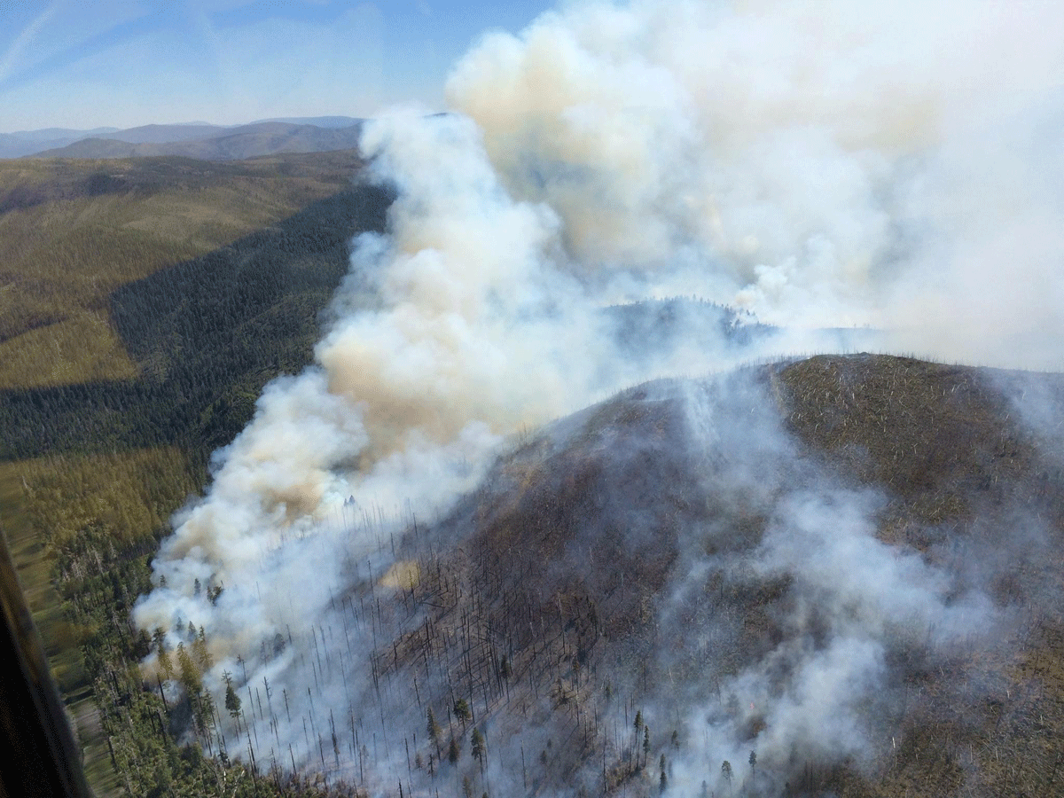
The Buckskin Fire (see photo), located in Curry county, approximately one mile SE of the Kalmiopsis Wilderness and six miles north of the California border, is approximately 100 acres in size. Due to safety issues with fire behavior, terrain, weather and many snags from the Biscuit Fire scar, hand crews did not engage on the fire yesterday evening. Aircraft water delivery was not effective due to winds.
Today, the Rogue River, Wolf Creek, Winema, Redmond and Prineville Hotshots, all 20-person highly trained initial attack crews, will be assigned to the Buckskin Fire. Two heavy helicopters are assigned to the fire and one air tanker is available at the Medford Airtanker Base. Two additional heavy helicopters and two medium helicopters with “helitack” support crews have been ordered. The Buckskin Fire is located approximately 10 miles SW of Cave Junction.
The Red Dog Fire located five miles SW of Onion Mountain on the Wild Rivers Ranger District, is 100% contained and mopped up and in patrol status.
Fire #367 (Little Onion) Fire is located two miles SE of Galice in Josephine County on the Wild Rivers Ranger District. The fire is currently four acres in size with a hand line completed around the perimeter of the fire. The fire is still active with a 20-person initial attack hand crew and miscellaneous overhead assigned.
Gold Beach Ranger District
The “Tom Fry” Fire (#355), located two miles SW of Agness, is four acres in size. The retardant line held yesterday and firefighters have completed containment line. Steep, rugged, and remote terrain, coupled with heavy fuel loading, is requiring an extended mop-up effort.
Fire #346 is located near Hog Mountain. The fire is 2 acres in size and firefighters have completed a line around it. Fire is in patrol status with one engine assigned.
#372 Miller Fire is 3.5 acres in size and is active but has not grown is size. Two engines, patrol unit, and 20-person initial attack hand crew are assigned. The fire is located near Elko Camp in the Hunter Creek area, is not threatening any structures, and is proximal to but not threatening South Coast Timber lands.
The North Smith Fire near Packsaddle Mountain is currently two acres in size. It is located near the SW corner of the Kalmiopsis Wilderness boundary. Four helitack crew members (Lakeview), and a Forest Service engine are assigned. This fire is contained and mop up efforts continue.
High Cascades Ranger District
Fire #362 (Cowboy Fire) is located one mile E of Robinson Butte on the High Cascade Ranger District. This fire is 1/10 of an acre in size and is contained, controlled and in patrol status.
For current recorded fire regulations, precautions, Industrial Fire Precaution Level (IFPL), and closure information 24 hours a day, call 800-267-3126
For additional fire and weather information, go to the Rogue River-Siskiyou National Forest website at http://www.fs.usda.gov/rogue-siskiyou or the Medford Interagency Dispatch Center at http://ormic.org/ or follow us on Twitter @RRSNF and the Oregon Department of Forestry’s blog swofire.com