August 19, 2015
The Collier Butte Fire is estimated at 8,000 acres, 25 percent contained and staffed with 385 personnel. The fire is burning in the northwest region of the Kalmiopsis Wilderness and remote Rogue River-Siskiyou National Forest System lands on the Gold Beach Ranger District. Fire managers have implemented direct and indirect containment lines to protect values at risk located to the south, west, and north of the fire. Rugged, steep terrain and abundant snags present a multitude of challenges to firefighter safety. Management of this fire is likely to endure for an extended period due to the shortage of firefighting resources and the limited access in the Kalmiopsis Wilderness.
Firefighters plan to burnout along Forest Road 3680 in order to strengthen the fireline. A smoke inversion is expected again today delaying burnout operations until afternoon. Winds are expected to be light from the northeast, switching to northwest later in the day. Firefighters will patrol and mop-up containment lines and watch for possible reburn due to falling tree needles accumulating in recently burned areas. Fuels reduction and chipping will take place along Forest Road 3318 today and along dozer line in the southern portion of the fire.
There are approximately 100 uncontained large fires in the nation resulting in a scarcity of resources. Crews, aircraft and qualified support personnel are in high demand and short supply. High-priority values at risk on other fires are in need of vast numbers of resources to protect lives, homes and infrastructure. Firefighting resources are being reassigned and moved to protect these values. Collier Butte Fire managers are strategically positioning available resources to focus on holding and securing primary and alternate containment lines. Additionally, aviation managers are coordinating the sharing of aircraft with other fires in southwest Oregon.
Closures:
Businesses along the south coast and Rogue River remain open and welcome visitors. Residents and visitors to Gold Beach, Brookings and nearby communities are encouraged to drive carefully as firefighter traffic in the area has increased.
The Curry County Fair in Gold Beach will take place Aug. 27-30 as planned.
August 19, 2015
Fire season in southwest Oregon continues to be extraordinarily hot and dry, and the Oregon Department of Forestry is committed to reducing the number of human-caused fires in forests and other wildland areas in Jackson and Josephine counties.
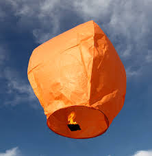
Releasing sky lanterns during fire season is one activity that is not allowed on ODF-protected lands. Fire season began June 5.
A sky lantern is commonly made of a lighted candle suspended beneath a plastic bag. The heat rising from the candle inflates the bag, which floats away and eventually returns to earth. If the lighted candle comes in contact with dry vegetation, a wildfire is likely to start.
The Oregon Department of Forestry’s Southwest Oregon District protects 1.8 million acres of state, private, county, and Bureau of Land Management lands in Jackson and Josephine counties. Fire season regulations also apply in county, state and BLM day-use areas and campgrounds.
For more information about the Oregon Department of Forestry’s fire season regulations, please call or visit the Southwest Oregon District unit office nearest to you:
- Medford Unit, 5286 Table Rock Rd., Central Point. (541) 664-3328
- Grants Pass Unit, 5375 Monument Dr., Grants Pass. (541) 474-3152
August 19, 2015
The Industrial Fire Precaution Level (IFPL) will increase to IFPL IV (four) on Saturday, August 22, 2015, at 12:01 a.m. for the entire Rogue River-Siskiyou National Forest.
On Oregon Department of Forestry-protected lands in Jackson and Josephine counties, IFPL III (three) is in effect.
Under IFPL IV, known as “General Shutdown”, all industrial actions are prohibited. This includes any personal and commercial use, firewood permits, power saws, and yarding.
Public use restrictions remain in effect, limiting the use of campfires to fire rings within designated campgrounds. No fires are permitted in wilderness. Current Public Use and Wilderness Restrictions can be found at http://www.oregon.gov/odf/pages/fire/precautionlevelmap.aspx
For more information, contact the Rogue River-Siskiyou National Forest at (541) 618-2200. For current information on IFPL levels, visit the Medford Interagency Communications Center website at http://ormic.org/fire_danger.shtml. Rogue River-Siskiyou National Forest fire prevention regulations are posted online at www.fs.usda.gov/rogue-siskiyou.
Please contact your local Ranger District office for more information and maps prior to travel on National Forest lands:
- Supervisor’s Office, Medford, (541) 618-2200
- Gold Beach Ranger District, (541) 247-3600
- High Cascades Ranger District
- Prospect, (541) 560-3400
- Butte Falls, (541) 865-2700
- Powers Ranger District, (541) 439-6200
- Siskiyou Mountains Ranger District (541) 899-3800
- Wild Rivers Ranger District
- Grants Pass, (541) 471-6500
- Cave Junction, (541) 592-4000
August 18, 2015
As persistent dry conditions continue across southwest Oregon, the Rogue River-Siskiyou National Forest is moving to “Extreme” fire danger, effective immediately.
Fire agencies in southwest Oregon are urging caution for all those participating in outdoor activities this season. Just one small spark from an unattended fire, muzzle of a gun, or the hot exhaust pipe on a vehicle can ignite fine fuels.
Current information on the National Creek Complex and the Collier Butte Fire, both burning on the Rogue River-Siskiyou National Forest, is available online at http://inciweb.nwcg.gov/. Additional online resources for fire conditions and fire information are available at http://ormic.org/.
For more information on current fire restrictions, call (541) 618-2200.
