August 13, 2017
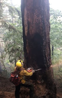
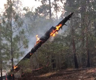
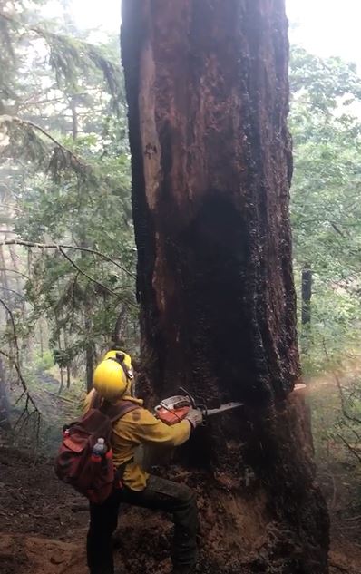
After sixty straight hours of firefighting, the Nugget Fire is 100 percent lined as of today. Initially, the terrain posed too many challenges to crews to build a direct fire line, such as steep slopes, an abundance of hazard trees and poor access leaving limited to no escape routes. However, over the past 24 hours significant progress has been made in improving access and creating safety zones. Local contractors from Butte Falls to Roseburg were brought in to assist with the removal of numerous hazard trees all within the fire’s estimated 5 to 10 acre perimeter. This allowed firefighters overnight to switch tactics from building indirect line away from the fire’s edge, to constructing a control line up against the perimeter of the burning landscape. Firefighters are now set up for a more successful and safe firefight.
 Air operations continues to play a vital role in the Nugget Fire. The continuous bucket drops being made have helped cool hot spots while ground crews chipped away at their respective goals. While members of the community will still see helicopters dipping out of the Rogue River in Gold Hill, this is to continue to suppress the interior heat while firefighters on the ground begin mopping up from the perimeter moving inward.
 The Nugget Fire was first reported late Thursday night burning on Nugget Butte in Gold Hill. The cause of the fire is under investigation. We would like to thank our partners and members of the community for the continued support.
The series of fires near Grizzly Peak are now 100 percent lined and 90 percent mopped up. Firefighters will be combing the area this week in order to ensure that no additional hot spots are present. The trail system will remain closed until firefighters wrap up their work and feel that there is no longer a threat to public health and safety. Thank you all in advance for your patience.
Please keep in mind that we are still in “Extreme” Fire Danger in Jackson and Josephine Counties. Make sure you and your family are aware of the current fire restrictions in place. For additional information about the Oregon Department of Forestry’s current fire restrictions, please visit: ODF Southwest on Facebook, or www.swofire.com.
August 11, 2017
Today, ODF Southwest firefighters and our cooperators tackled numerous fires on ODF-protected land across Jackson and Josephine Counties. While this storm has pushed our team to its limits, we are holding true to keeping fires as small as possible, and keeping the community safe. Nearly every fire we have shared information on this week is close to being fully lined and in mop up, except for the following:
The Nugget Fire is still challenging firefighters as the steep terrain covered in snags poses a hazard to all personnel on the ground. Crews are continuing to work on fire line around the perimeter, but access is also playing a role in the demanding firefight. The fire is still estimated to be 5 to 10 acres by ODF’s air attack, but we have not yet mapped the fire due to the same challenges previously mentioned. Overnight, firefighters will be focusing on building and strengthening control line. While the fire will be letting off smoke, the fire activity remains moderate primarily in the interior of the burn. No homes are threatened by this fire.
Also, the series of Grizzly Peak Fires are being wrapped up, but additional mop up will be taking place tomorrow before we call all five of these fires 100% contained. Since air operations will continue cooling hot spots tomorrow, and firefighters will be working throughout the Grizzly Peak area, a temporary closure of the Grizzly Peak Trail system is in effect in order to protect public health and safety. For the full information on that closure, visit www.swofire.com.
We would like to thank the community for the tremendous amount of support we have all felt while working on countless number of fires since this storm took off Monday. We are also incredibly grateful for the partnerships in place with U.S. Forest Service Rogue River Siskiyou National Forest, Bureau of Land Management Medford District, all local city and county agencies, ODF Klamath-Lake District, Cal Fire and finally, Oregon Department of Forestry IMT I. The amount of fires we have been able to keep small is a testament to our superb partnerships throughout our area.
August 11, 2017
With increased fire activity on Grizzly Peak near Ashland, the Bureau of Land Management (BLM) Medford District jointly with the Oregon Department of Forestry Southwest Oregon District have decided that a temporary closure of the Grizzly Peak Trail system is necessary in order to protect public health and safety. The closure is effective immediately and will be in place until the area is deemed safe for public access.
Currently, firefighters are still engaged on Grizzly Peak; however, only three of the five fires initially reported are still actively burning. The first two fires were knocked down and 100% contained by early afternoon. Both are less than an acre in size. Firefighters are engaged on the final three fires tonight. The fires range from ¼ acre to 2 acres, and are each at least 30% mopped up and 100% lined. We will continue to work on these fires swiftly and efficiently in order to eliminate any further risk to public and firefighter safety.
Closure signs will be placed at main entry points to the area; however, maps of the closure area can be obtained through the BLM Medford District Office. The Grizzly Peak Trail is on federal land administered by the Bureau of Land Management out of its Medford District office. It is a popular hiking area that attracts several visitors during the summer months. Therefore, we hope this precaution keeps both visitors and firefighters safe as they continue to make progress on the series of fires on Grizzly Peak.
The full Emergency Closure Notification is below. For additional information, please reach out to the BLM Medford District office at (541) 618-2200, or the Oregon Department Southwest Oregon District Medford Unit at (541 664-3328.
###
U.S. DEPARTMENT OF THE INTERIOR
BUREAU OF LAND MANAGEMENT
MEDFORD DISTRICT
3040 Biddle Rd.
Medford OR 97504
EMERGENCY CLOSURE OF PUBLIC LANDS: Jackson County, Oregon
AGENCY: Bureau of Land Management, Medford District Office, Oregon
ACTION: Temporary closure of public land in Jackson County, Oregon.
SUMMARY: The Medford District, Bureau of Land Management (BLM) is giving notice that we are temporarily closing the Grizzly Peak Trails beginning on August 11, 2017. These restrictions are to protect public health and safety (43 CFR 9268.3(d)(1).
THE CLOSED/RESTRICTED AREA ARE:
The Grizzly Peak Trail system – Township 38S, Range 2E, Section 8, 17, 18, and Road 38S-02W-9.2.
BLM will post closure signs at main entry points to this area. You may obtain maps of the closure area and information from the Medford District Office.
DATES: This closure will be in effect from the date of signature until the area is deemed as safe for public access.
FOR FURTHER INFORMA TION CONTACT: Kristi Mastrofini, Ashland Resource Area Field Manager, 3040 Biddle Road, Medford, OR 97504, telephone (541) 618-2438.
DISCUSSION OF THE RULES: Under the authority of 43 CFR 9268.3(d)(1)(i), BLM will enforce the following rule on public lands within the closed area:
You may not travel on the Grizzly Peak trail in Township 38S, Range 2E, Section 8, 17, 18 or the road leading to the trail, Road 38S-02E-9.2 beyond Shale City Road.
EXEMPTIONS: Persons who are exempt from these rules include:
· Any Federal, State, or local officeror employee in the scope of their duties;
· Members of any organized rescue or fire-fighting force i n performance ofan official duty;
· Any personauthorizedin writing by the Bureauof Land Management.
PENALTIES: Authorities for this closure are section 303(a) of the Federal Land Policy and Management Act of 1976 (43 U.S.C. I733(a)) and 43 CFR 8360.0-7. Any person who knowingly and willfully violates any closure order issued under § 9268.3(c)(2) of this title shall be fined not more than $1,000 or imprisoned for not more than 12 months, or both. Such violations may also be subject to the enhanced penalties as provided for by 18 U.S.C. 3571.
August 10, 2017
ODF IMT 1
BILL HUNT, INCIDENT COMMANDER
Shady Cove, Oregon – Wednesday evening’s thunderstorm activity brought much needed precipitation to the Flounce Fire with as much as a quarter inch of rain in some areas. The fire stands at an estimated 690 acres and 10 percent contained.
While the rain served as a welcome relief to cool portions of the fire down, it also creates a slew of safety concerns. The added moisture on the ground, combined with burning root systems, weakens trees that could potentially fall at a moment’s notice, compromising firefighter safety and carrying burning material downhill across fire lines. Also of concern is the potential for rock slides in the steep, rugged terrain. The area of greatest concern is the southeast corner of the fire where the rocky cliffs make it difficult to establish solid containment lines. Helicopters will focus bucket drops in that area to support ground forces.
The west flank of the fire is in excellent condition. Crews will continue extensive mop up along the western line while also being available to support Oregon Department of Forestry’s Southwest Oregon District and its cooperators by responding to new fires in Jackson and Josephine Counties.
A Level One (Be Ready) evacuation notice remains in effect for residents on Evergreen Drive and Lewis Road near Prospect. Jackson County Emergency Management and local fire agencies will continue to coordinate with fire team personnel in evaluating the situation. Level One of the three-level ‘Be Ready, Get Set, Go!’ evacuation system is something everyone should incorporate into their daily lives. It’s all about having a plan, including assembled emergency kits, being aware of escape plans and evacuation routes and sites, and being ready to go at a moment’s notice, regardless of the emergency. Learn more at our local emergency managemt page
www.rvem.org, or
wildlandfirersg.org.Roughly 650 personnel are currently assigned to the Flounce Fire. Fire crews are also being supported with 9 helicopters, 19 engines, and 17 water tenders.
August 9, 2017
Today, ODF Southwest firefighters worked diligently chasing smokes and knocking down multiple fires throughout Jackson and Josephine Counties. While several of our starts are dead out, there are a handful of fires that crews are continuing to work on overnight.
The Stratton Creek Fire, burning seven miles northwest of Merlin, is estimated to be 30 acres as of nightfall. The fire originated as three separate fires burning in mixed terrain consisting of tall brush and timber on the north side of the Rogue River near Hellgate Canyon Bridge. Two of the three fires burned together late this evening which will pose a challenge to firefighters as they work to line the fire in a steep, rugged landscape. The third fire has already been completely knocked down by air and ground resources. Firefighters will continue to work on containment tonight. Air operations will resume in the morning.
The Reuben Fire, which we mentioned earlier today, was burning roughly five air miles north of Grave Creek Bridge and the Rogue River Trail. The initial estimate put the fire at five acres, but as of this evening the fire was knocked down and 100% lined at 10.75 acres. Crews will continue to mop up the interior of the fire tonight.
The Doe Spring Fire is burning right off the Josephine – Douglas County border just north of Mount Reuben. Thanks to the collaborative efforts between ODF Southwest and the Douglas Forest Protective Association, firefighters are inching closer to getting a line around the full perimeter of the roughly 6.5 acre fire. We truly appreciate the collaborative, aggressive initial attack that both agencies are displaying.
The Redwood Highway Fire is now in extensive mop up. Multiple agencies responded to the roughly 10 acre fire burning in a salvage yard and adjacent wildland off Redwood Highway 199 and Airport Drive in Cave Junction. Due to the fantastic teamwork by structural and wildland firefighters alike, the fire was knocked down quickly and all evacuation orders have been lifted. No structures were lost. Although Redwood Highway 199 was initially closed to through traffic, it is open tonight. However, firefighters will be working on mopping up this fire for several days. Due to the variety of materials burned, hot spots are more prone to pop up. We are working to eliminate any chance of reignition on this fire.
Finally, several additional fires were located and extinguished throughout the day. Tonight, firefighters are still following up on new reports of smoke in order to hold true to our mission of keeping fires small and keeping our community safe. As always, we would like to thank all of our partnering fire agencies for the continued support and cooperation.
We would like to remind everyone that the fire danger level on Oregon Department of Forestry protected lands in Jackson and Josephine counties remains at “extreme” (red). For a full list of the public restrictions currently in place, visit our Facebook page: @ODFSouthwest or our website: www.swofire.com.
 Air operations continues to play a vital role in the Nugget Fire. The continuous bucket drops being made have helped cool hot spots while ground crews chipped away at their respective goals. While members of the community will still see helicopters dipping out of the Rogue River in Gold Hill, this is to continue to suppress the interior heat while firefighters on the ground begin mopping up from the perimeter moving inward.