North Klamathon Fire Update 07/16/18 AM
North Klamathon Update
Monday, July 16, 2018
Russell Wilstead, Incident Commander
|
Location: Approx. 4 mi. S of Greensprings, OR
Total Size Including Klamathon: 38,008 acres
Percent Contained: 95%
|
Start Date: July 5, 2018.
Cause: Under Investigation
Cost to Date Including Klamathon: $31,034,000
|
|
Type 1 Hand Crews
|
Type 2 Hand Crews
|
Engines
|
Type 1 Helicopters
|
Type 2 Helicopters
|
Type 3 Helicopters
|
Dozers
|
Total Personnel
|
|
0
|
3
|
10
|
0
|
0
|
1
|
1
|
156
|
To facilitate safe travel and provide close operational supervision, the portion of the Klamathon Fire in Oregon is now being managed as a separate fire. The Incident Command Post for the North Klamathon fire is at the Ashland Middle School in Ashland, Oregon.
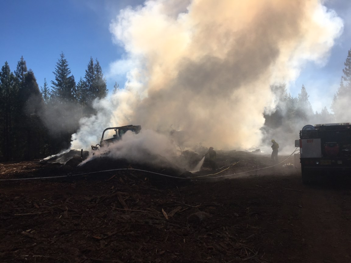
Yesterday’s mission to retrieve equipment and repair fire lines was delayed because of widespread lightning that moved through southwest Oregon. Many resources assigned to the North Klamathon Fire including firefighters, engines, and helicopters were assigned to initial attack on multiple new starts. The resources remaining on the North Klamathon fire continued to patrol and mop-up along fire lines. The projected containment date has been extended one day, with full containment expected today.
Today seven engines, a water tender and three hand crews will remain available for initial attack on new fires resulting from yesterday’s lightning. Three engines, one water tender, one dozer, two excavators, and three hand crews remain assigned to equipment retrieval and fire suppression repair on the North Klamathon fire. Fire suppression repair is a series of immediate post-fire actions taken to repair impacts to the land and minimize the potential for soil erosion and other issues that might arise from fire line construction. Fire suppression repair is ongoing on the fire’s southern perimeters and is beginning on the Oregon side in the Cascade-Siskiyou National Monument and the Soda Mountain Wilderness.
Today’s weather forecast calls for the beginning of a hotter, drier trend lasting into mid-week.
Trails and roads that connect to the Medford District Bureau of Land Management closure order area continue to be patrolled by law enforcement agencies. Road closures are in place near Pilot Rock, on the Buckhorn Springs Road, Soda Mountain Road, Baldy Creek Road, and Mill Creek Road. The Pacific Crest Trail is closed between Highway 99 and Highway 66.
Information about the North Klamathon Fire is available at 503-475-8009.
Wagner Creek and Garner Complex Update 7/16/18
WAGNER CREEK & GARNER COMPLEX UPDATE
@swofire
@ODFSouthwest
QUICK FACTS
Incident Start Date: 7/15/2018
Incident Start Time: Approx. 9:00 a.m.
Incident Type: Wildfire
Cause: Lightning
Incident Location: Jackson & Josephine counties
Land Threat: Private, BLM
Command Agency: ODF
Complex Size: 275 acres
Containment: 30%
Expected Full Containment:
Civilian Injuries: 0
Firefighter Injuries: 0
Lightning Strikes: Approx. 1,000 across the District
Confirmed Wildfires: 55
Structures Threatened: 20+
Structures Destroyed: 0
Structures Damaged: 0
CURRENT SITUATION
Situation Summary:
Date: 7/16/2018 Time: 10:00 a.m.
Garner Complex in Josephine County
Swamp Creek: 16 miles north of Rogue River. Estimated at 3 acres. Ground and aerial resources are enagaged. No structures threatened.
Little Grayback: 8 miles east of Cave Junction. Estimated at 2 acres. Several ground resources engaged, securing the perimeter. Smoke will be present. No structures threatened.
Spencer Creek #3: Highly visible from Grants Pass – Illinois Valley, 12 miles south of Grants Pass. Estimated at
10 acres. Ground and aerial resources are engaged. No structures threatened.
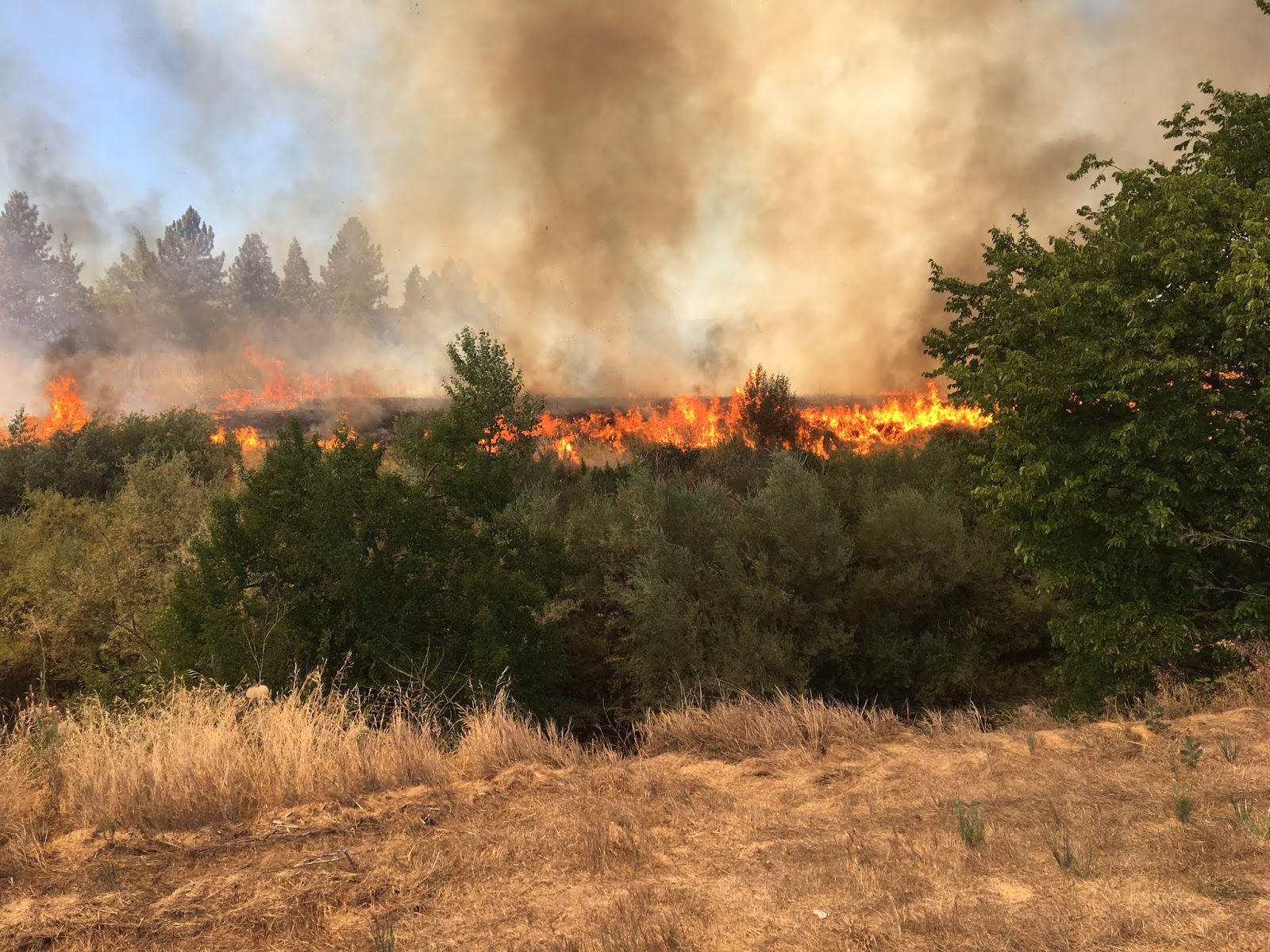
Wagner Creek Complex in Jackson County
 Green Top Mountain: 5 miles northeast of Eagle Point. Estimated at 125 acres. Roughly 90% of the perimeter control line is complete, 5% contained. There was a roughly 4 acre spot fire this morning that has already been knocked down and brought back into the main body of the fire. Ground and aerial resources
are engaged. No structures are threatened.
Sterling Creek: 7 miles south of Jacksonville. Estimated at 100 acres. Roughly 55% of the perimeter control line is complete. Ground and aerial resources engaged. Level 3 “Go!” evacuations are in place impacting the even number addresses only off the 7400-9400 blocks of Sterling Creek Road. Rogue Valley structural units
are working on home protection and defense.
Wagner Creek Area: Highly visible off I-5. Please contact U.S. Forest Service, Rogue River-Siskiyou National Forest for additional details as it is burning on federal land; ODF is not engaged.
Trail Creek & Elk Creek Drainage: Multiple fires are burning in the area surrounding Cleveland Ridge, Elk Creek, and the Trail Creek area which is roughly 5.5 miles north to northwest of Shady Cove. The largest fire in this area is estimated at 10 acres. Ground and aerial resources are engaged. No structures are threatened.
There are several other fires in Jackson and Josephine Counties that we are working diligently to knock down and contain. Our air attack platform will be performing reconnaissance flights the entire day. Please know that all other ODF fires are an acre or less at this time, and are posing no threat to our communities.
Crews Fan Out Across ODF Medford Unit on Lightning-Caused Fires
ODF Southwest Oregon District crews started rolling before 9:00 a.m. today on more than two dozen lightning-caused fires. Most of the fires have been contained at less than 1/10th of an acre. The largest fire is a 30-acre blaze on Green Top Mountain, approximately 5 miles northeast of Eagle Point. Crews, bulldozers, helicopters and air tankers have been ordered to fight that fire.
This morning’s lightning storms hit many parts of Jackson County, starting small fires in the following areas: Anderson Butte, Wagner Butte, Hells Peak, Kane Creek, Hyatt Prairie, Burnt Peak, Sterling Creek Road, Cleveland Ridge and several other areas.
Dispatchers expect to have more smokes reported this afternoon. Mountain-top cameras and aircraft are watching for fires across the Siskiyou Mountains in Jackson and Josephine counties, as well as the west slope of the Cascade Range.
[ Update 4:10 p.m. ]
More than a dozen lightning-caused fires have also been discovered in Josephine County by ODF’s Grants Pass Unit crews. The largest fire is approximately 5 acres on Little Grayback Peak, east of Cave Junction.
In Jackson County on ODF’s Medford Unit, crews and aircraft are working on the Sterling Creek Fire, approximately 15 acres and the Hells Peak Fire, approximately 10 acres. The largest fire on the district, Green Top, continues to grow and is estimated at 45 acres. Air Tanker 62 and other aircraft have been ordered to drop retardant and water on this fire.
Let’s Help our Community by Reducing Fire Starts
 Yesterday, was the first of many challenging days we anticipate on ODF Southwest Oregon District. While all of yesterday’s starts are still under investigation, they have all been deemed human-caused. Therefore, we are urging every member of our community to use extra caution when outdoors. It is going to take all of us working together to reduce the amount of wildfires this season.
 In addition, the anticipated forecast for the end of this week is priming the District to enter into an Extreme (Red) Fire Danger Level. While there is no date set in stone currently, it is important for everyone to be aware of the upcoming changes and stay informed. If you are not already, please monitor are public Facebook page for the most up-to-date information. We, at ODF Southwest, want to take every step necessary to keep you, your families, and our firefighters safe.
Here is a quick recap of what our firefighters across Jackson and Josephine counties faced yesterday:
The Truck Road 399 Fire was discovered in the early morning hours July 9 near Butte Falls. Firefighters were able to knock down the fire at roughly a 0.5 acre; however, the heavy timber made mop up a lengthy process. This kept crews tied to the fire for several hours.
Later that morning, firefighters were able to make another amazing catch. The Beacon Hill Fire near I-5 milepost 55 was called in around 10:30 a.m. ODF Southwest and several mutual aid resources were able to make a quick stop on this 0.37 acre fire a mere 20 minutes later. This is a testament of our coordinated firefighting system we have throughout Jackson and Josephine Counties.
Just after 1:00 p.m., ODF Southwest assisted our partners, U.S. Forest Service Rogue River-Siskiyou National Forest, on a fire up near Butcherknife Creek NE of Selma. Although the terrain proved to be difficult, the teamwork thrived. The fire was wrapped up at approximately 10 acres.
By the afternoon, the Red Flag Warning issued by our local National Weather Service came to fruition on the fire line. Another report of a grass fire came in just after 4:30 p.m. roughly seven miles west of Grants Pass. The gusty winds and dry conditions posed a challenge to the several firefighters on the ground from ODF Southwest, Rural Metro Fire, and Grants Pass Fire. However, the collaboration of firefighting efforts on the ground and in the air paid off. The final fire size of the Riverbanks Road Fire is 7.9 acres.
In addition to these fires, we also provided mutual aid to several of our partner agencies including Medford Fire-Rescue (Chevy Way Fire – pictured below) and Illinois Valley Fire District (Redwood Highway Fire – details @IVFD), and other smaller incidents.
Thank you, as always, to our outstanding partners and their diligent work to keep our communities safe this Fire Season.