Crews continued to make progress on the Upper Applegate Fire today. Mop up was completed along the Upper Applegate Road, which will significantly reduce visible smoke from the road. Some interior islands burned out today, creating small columns of smoke. The fire remains within the containment lines. Extremely steep terrain and significant amount dead trees continue to be the biggest challenge in completing the remaining direct line around the fire.
Crews have installed hose around approximately 80% of the fire. There are direct lines around 35% of the fire, with indirect lines around the rest of the fire.
A GPS flight at 11:00 AM today mapped the Upper Applegate Fire at 830 acres. Mapped heat was consistent with where fire growth is expected, including primarily backing fire working from the top of the knob down to existing lines. The aircraft used satellite communications to update fire operations in near real time and help make informed tactical decisions. No heat was detected outside of existing fire lines.
Efforts tonight include a small burn out planned for the far southeastern corner to help connect the fire with the containment lines. Crews will continue bolstering hand and dozer line on the north side of the fire.
A community meeting is scheduled for 7:00 -8:00 PM on June 25 at the Ruch Elementary School, 156 Upper Applegate Road. Incident Commander Larry Kazakoff, along with agency partners, will provide an update on the fire and answer questions from the community.
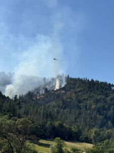
More than 430 personnel are assigned to this incident, including 18 20-person crews, six engines, five tree fallers, four bulldozers and numerous overhead. Four helicopters of various sizes were assigned to the fire again today, with additional helicopters and air tankers available when needed. Resources remain focused on bolstering the line, especially on the eastern side of the fire, which has been difficult to work.
Level 2 – BE SET evacuation notices remain in effect by the Jackson County Sheriff’s Office and Emergency Management for Zones JAC-434 and JAC-436. More information about zones and locations is available here: https://protect.genasys.com/.
This fire is affecting private, BLM and U.S. Forest Service (USFS) land on the Rogue River-Siskiyou National Forest. It was first reported in the late afternoon of Thursday, June 20. The cause of this fire is currently under investigation.
The fire danger level on the ODF Southwest Oregon District is moderate (blue) and regulations are in place. Please be aware of and follow all current restrictions to help reduce the risk of fires in our communities. Fire season information is also available online at our Facebook page: @ODFSouthwest and our website: www.swofire.com.