RAND, Ore. (July 17, 2024) – Firefighters have been responding to several fires along the lower portion of the Rogue River following thunderstorms on Tuesday night. Resources are engaged on 10 small fires in Josephine County, with the majority located on Bureau of Land Management public lands on both sides of the river northwest of Rand and Galice. The fires range in size from 1/100 of an acre to one acre. These fires have likely remained small due to rain that came with the weather system, as well as an aggressive initial attack from firefighters. Aircraft has been key on these incidents, as all fires are in remote areas or in difficult terrain. Firefighters are hiking as far as two miles to reach fires on steep, dangerous ground.
The current list of fires are as follows:
- Crooks Creek Fire, caught at one acre. Currently 100% lined and 100% mopped up. Located in the hills above Crooks Creek Road, north of Dryden and east of Selma.
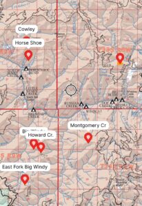
- Horseshoe Bend Fire, holding at an estimated quarter-acre. Located north of Horseshoe Bend Campground, north of the Rogue River. Firefighters are on scene and using helicopters due to remote location and no road access. The U.S. Forest Service Rogue-River Siskiyou National Forest and ODF are encouraging people to avoid camping at all Horseshoe Bend campsites while fire operations use the river for helicopter-bucket dipping and working in the area.
- Howard Creek Fire, extinguished by aircraft at an estimated 1/100 of an acre. Located northwest of Rand and south of the Rogue River. Firefighters continue to monitor this area.
- East Fork Big Windy Fire, estimated to be 1/100 of an acre. Located east of East Fork Big Windy Creek and south of the Rogue River on steep, remote county with limited access. ODF firefighters are on scene with one 20-person crew hiking into the fire area.
- Big Windy Creek, estimated to be a quarter-acre. Located on steep, remote ground just north of the East Fork Big Windy Fire. Tree fallers and a 20-person crew are assigned to the incident and hiking in.
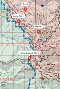
- Trout Creek Fire, estimated to be half an acre. Located north of Trout Creek and south of the Rogue River, southwest of the Zane Grey Cabin. This fire is a two-mile hike from the nearest road. Two 10-person crews are assigned to the fire, along with a bulldozer. Firefighters are cutting a significant amount of dead trees to clear a path to the incident.
- Long Gulch Fire, estimated to be a quarter-acre. Located southwest of the Trout Creek Fire. This fire is 100% lined and 85% mopped up. Resources will continue until the fire is completely extinguished.
- Missouri Creek Fire, estimated to be half an acre. Located north of Bear Camp Road and south of the Zane Grey Cabin. Firefighters are hiking down to the fire.
- Montgomery Creek Fire, caught and extinguished at 1/100 of an acre. Located southwest of Rainie Falls and south of the Rogue River. Currently 100% lined and 100% mopped up.
- Hewett Creek Fire, estimated to be just under a quarter-acre. Currently 10% lined and 100% plumbed with fire hose for water access. Located south of BLM road 32-10-36. A 20-person crew is on scene and actively working on lining the rest of the fire.
An additional two fires, the Anna Creek and Cowley Creek Fires, were initially reported but not found by firefighters and are likely duplicate reports. Firefighters and aircraft will continue to monitor the area for additional fires.
Chances for thunderstorms are once again predicted for this weekend. While these fires cannot be prevented, many can. Please be aware of and follow all current restrictions to help reduce the risk of human-caused fires in our communities. Additional information is available here:
- The ODF Southwest Oregon District: https://swofire.com/
- The RRSNF Alerts and Notices page https://www.fs.usda.gov/alerts/rogue-siskiyou/alerts-notices and website homepage https://www.fs.usda.gov/rogue-siskiyou
- The BLM OR/WA Fire Management Page: https://www.blm.gov/orwafire
- Follow the ODF, RRSNFand BLM on Facebook
- Follow the ODF, RRSNF and BLM on Twitter