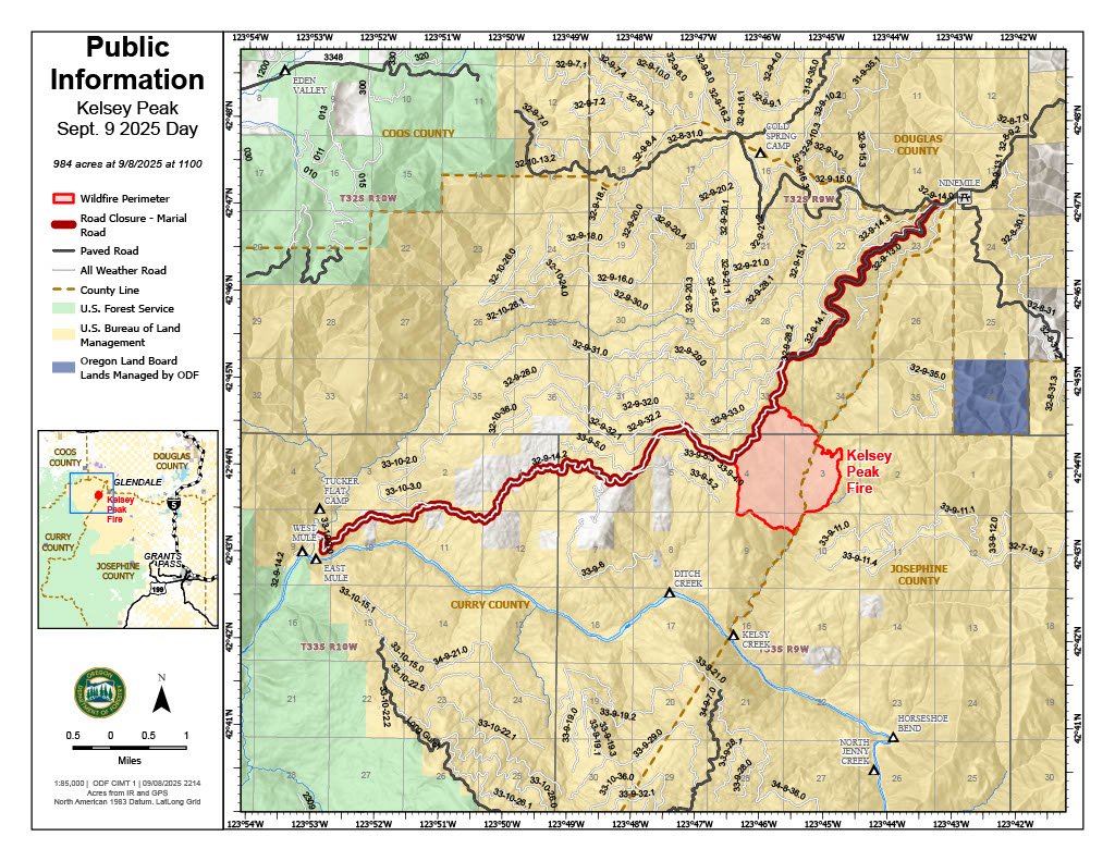
This will be the final evening update unless conditions significantly change
LOWER ROGUE RIVER CORRIDOR, Ore. – Resources assigned to the Kelsey Peak Fire continued to push forward on lining the perimeter Tuesday, making headway from the northwestern to the northeastern sides of the incident. Cooler temperatures and intermittent rain has naturally helped to decrease fire behavior, providing opportunities for firefighters to make fast progress in areas that once proved difficult in hotter weather and more active fire. It’s also allowing firefighters to put in direct line up against the fire’s edge, keeping the fire as small as possible and minimizing further growth.
Due to the current conditions, minimized fire behavior and work completed by resources on the line, the Curry County Sheriff’s Office has decreased the Level 3 – Go Now evacuation for the Rogue River Ranch, Tucker Flat Campground and the nearby area of Marial to a Level 2 – Be Set notice. The Level 1 – Be Ready evacuation for Zone JCU-801 in Josephine County to the southeast of the fire remains in place.
Today, resources furthered plans of protection for these structures in the Level 2 evacuation area, as well as the Zane Grey Cabin. These procedures are precautionary, however with multiple fires in the area, firefighters are taking every opportunity possible to ensure plans are in place, especially with residents and guests returning.
Meanwhile, mop-up operations are continuing on the northeastern lines, reaching up to 70-feet into the interior of the fire. This work ensures all lingering heat is extinguished and won’t flare up again in warm, windy weather, expected by the end of this week. As lines are connected and solidified, mop-up work will begin on other portions of the fire, boosting containment across the incident.
The Rogue River remains open for permitted boaters near the Kelsey Peak Fire, however further downriver, restrictions are in place. Additional information is available here: https://tinyurl.com/MoonComplexInciweb
Firefighting activities on the Kelsey Peak Fire may cause delays; boaters are encouraged to use caution on this part of the river.
Closures: The Rogue River Trail is closed from Horseshoe Bend to Flora Dell. A temporary closure of a portion of the Grave Creek to Marial Backcountry Byway (BLM Road 32-9-14.2) has been implemented by the BLM Grants Pass Field Office. The public is strongly encouraged to avoid the entire Byway to facilitate safe firefighter access on the steep, narrow, windy road. Unauthorized individuals may not enter closed areas, and all uses—including hiking, hunting and dispersed camping—are prohibited. Please see the map for full closure information on the BLM website: https://www.blm.gov/programs/public-safety-and-fire/fire-and-aviation/regional-info/oregon-washington/fire-restrictions
Evacuations: The Curry County Sheriff’s Office decreased the Level 3 – GO NOW evacuation order for the area of Rogue River Ranch, Tucker Flat Campground and the nearby area of Marial to a Level 2 – BE SET. The Josephine County Sheriff’s Office and Emergency Management issued a Level 1 – BE READY evacuation notice Zone JCU-801. More info: https://tinyurl.com/KelseyPeakEvacs
Temporary Flight Restriction (TFR): A “TFR” is in place at an altitude from the surface up to and including 7,000 feet, daily (24 hours) until further notice. Complete information is available at https://tfr.faa.gov/tfr3/?page=detail_5_8274. Flying a drone near or around a wildfire compromises the safety of pilots and interferes with firefighting efforts.

