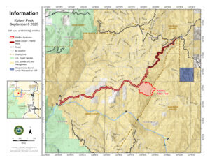
LOWER ROGUE RIVER CORRIDOR, Ore. (Sept. 6, 2025) – Challenging conditions once again were felt by resources assigned to the Kelsey Peak Fire, burning on Bureau of Land Management (BLM) land along the Lower Rogue River Corridor roughly 26 miles northwest of Grants Pass. Smoky conditions persisted across the fire today, contributing to lower intensity fire behavior, but shutting down air operations for a second day in a row. Despite the lack of air support, firefighters were able to hold the established lines and even build on some of them today, bolstering their overall strength. Storm systems moving through the area could bring erratic winds tonight, which could naturally increase fire behavior; firefighters working the evening shift are prepared for this possibility. Resources include five 20-person crews, 13 engines, two water tenders and medical personnel.
With the complexities of the topography, steep terrain, and dense brush, as well as thunderstorms in the forecast for the coming days bringing added threats of new fire starts, the decision was made by the Oregon Department of Forestry (ODF) Southwest Oregon District and BLM Medford District to order ODF Complex Incident Management Team (CIMT) 1. The team will bring added resources to the fire, as well as release local ODF personnel to return to their normal initial attack response readiness in the face of potential new fire starts. The team will arrive on Sunday afternoon and be in-briefed with the current fire situation before taking command of the incident Monday morning.
This afternoon, the Josephine County Sheriff’s Office and Emergency Management placed Zone JCU-801, located mostly southeast of the fire, on a Level 1, BE READY evacuation notice. Additionally, BLM Grants Pass Field Office has temporarily closed a portion of the Grave Creek to Marial Backcountry Byway (BLM Road 32-9-14.2) and Sheriff John Ward of the Curry County Sheriff’s Office issued a Level 3, GO NOW, evacuation order for the area of Rogue River Ranch, Tucker Flat Campground and the nearby area of Marial. The public is strongly encouraged to avoid the entire Byway to facilitate safe firefighter access on the steep, narrow, windy road. Members of the public may not enter closed areas, and all uses—including hiking, hunting and dispersed camping—are prohibited. Please see the map for full closure information on the BLM website: https://www.blm.gov/programs/public-safety-and-fire/fire-and-aviation/regional-info/oregon-washington/fire-restrictions
Thunderstorms began to materialize around 5 p.m. in southern Oregon. Numerous cloud-to-ground lightning strikes have been recorded up the entire west side of Jackson County with a small cluster in southeastern Josephine County at the time of this release. While the system brought some rain, firefighters are ready to respond to new reports of fire tonight. ODF’s Detection Center staff are monitoring these strike areas for smoke and a reconnaissance flight is planned for this evening with more flights planned for Sunday morning.
The fires along the Lower Rogue River Corridor were started by lightning during a thunderstorm last Wednesday; the following is a complete list of the fires that affected ODF-protected land:
| Fire | Size (Acres) | Status |
| August Knob Fire | 1/100 | 100% lined, 100% mopped up |
| Bald Ridge Fire | — | Unable to locate (UTL) |
| Bald Ridge Fire #2 | 1/4 | 100% lined, 100% mopped up |
| Big Meadow Fire | 1/10 | 100% lined, 100% mopped up |
| Cold Springs Fire | 1/10 | 100% lined, 100% mopped up |
| Ditch Creek Fire | 1/10 | 100% lined, 100% mopped up |
| Hewitt Creek Fire | 1/10 | Turned over to USFS |
| Jeep Ridge Fire | 1/100 | 100% lined, 100% mopped up |
| Kelsey Peak Fire | 506 | 25% lined, 0% mopped up |
| Marial Fire | 1/2 | 100% lined, 100% mopped up |
| Mule Creek Fire | 2 | 100% lined, 100% mopped up |
| Quail Creek Fire | 1/10 | 100% lined, 100% mopped up |
Additional fires burning downriver near the Paradise and Half Moon Bar Lodges are on ground protected by our partners at the U.S. Forest Service Rogue River-Siskiyou National Forest and the Coos Forest Protective Association; please follow their pages for additional fire updates.
Help firefighters by following all current regulations during Extreme fire danger: