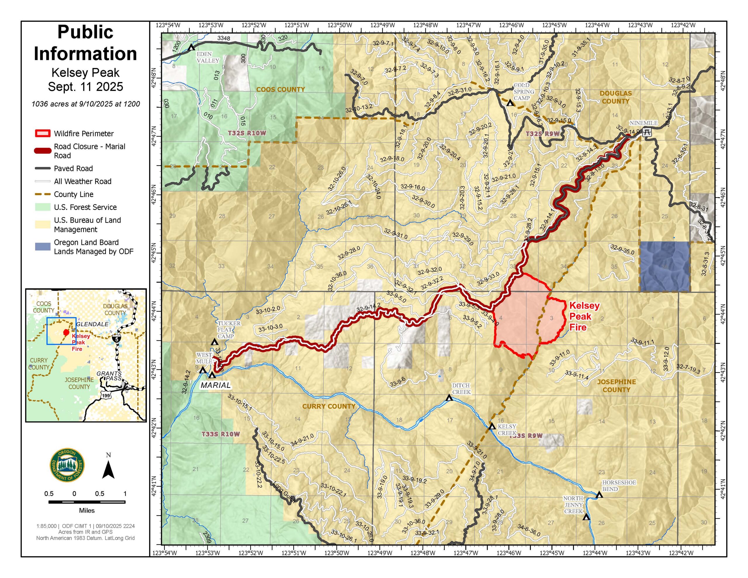
LOWER ROGUE RIVER CORRIDOR, Ore. – Progress mopping up on the Kelsey Peak Fire has improved containment to 23%. This increased containment reflects the focused work crews have been accomplishing each day. Some portions of the fire have mopped up 100 feet into the interior of the fire.
“We aren’t building line out there to hold the fire today,” explained Operations Section Chief, Jason Pettigrew. “We are building line to hold the fire when its warmer and winds try to push it.”
Yesterday, helicopters were used to drop water on hot spots adjacent to the perimeter, moderating fire behavior and allowing firefighters to cool the area by stirring in water. They will be available again today for bucket work supporting firefighters and will be used to bring pumps and hose to the fireline in difficult terrain. This will improve water availability for mop-up.
Crews today are using infrared maps from an Unmanned Aircraft (UAS) flight late yesterday afternoon to identify areas of heat as they work around the fire’s edge mopping up. Using a drone (UAS) throughout the day provides immediate intel about hot spots to crews through updated maps, making mop up more efficient and improving safety as firefighters aren’t traversing the rugged terrain feeling for heat.
The Rogue River remains open for permitted boaters near the Kelsey Peak Fire, however firefighting activities may cause delays and smoke may limit visibility; boaters are encouraged to use caution on this part of the river.
Closures: The Rogue River Trail is closed from Horseshoe Bend to Flora Dell. A temporary closure of a portion of the Grave Creek to Marial Backcountry Byway (BLM Road 32-9-14.2) has been implemented by the BLM Grants Pass Field Office. The public is strongly encouraged to avoid the entire Byway to facilitate safe firefighter access on the steep, narrow, windy road. Unauthorized individuals may not enter closed areas, and all uses—including hiking, hunting and dispersed camping—are prohibited. Please see the map for full closure information on the BLM website: https://www.blm.gov/programs/public-safety-and-fire/fire-and-aviation/regional-info/oregon-washington/fire-restrictions
Evacuations: The Curry County Sheriff’s Office decreased the Level 3 – GO NOW evacuation order for the area of Rogue River Ranch, Tucker Flat Campground and the nearby area of Marial to a Level 2 – BE SET. The Josephine County Sheriff’s Office and Emergency Management has a Level 1 – BE READY evacuation notice for Zone JCU-801 in place. More info: https://tinyurl.com/KelseyPeakEvacs
Temporary Flight Restriction (TFR): A “TFR” is in place at an altitude from the surface up to and including 7,000 feet, daily (24 hours) until further notice. Complete information is available at https://tfr.faa.gov/tfr3/?page=detail_5_8274. Flying a drone near or around a wildfire compromises the safety of pilots and interferes with firefighting efforts.
Information for the Moon Complex is available here: https://tinyurl.com/MoonComplexInciweb.

