September 14, 2020
Update for Sept. 14, 2020, 3 p.m.
Oregon Department of Forestry IMT 3 Link Smith, Incident Commander and Oregon State Fire Marshal’s Red Team Ian Yocum, Incident Commander
Holiday Farm Fire Information: 541-357-9729 (7am-10pm)
Lane County Non-Emergency Call Center: 541-682-3977 (7am-10pm)
Linn County Non-Emergency Call Center: 541-812-2260
Facebook: https://www.facebook.com/HolidayFarmFire/
Email: holidayfarmfireinfo@gmail.com
Virtual public meeting from Sept. 13, 2020: https://www.facebook.com/HolidayFarmFire/videos/769103733879341
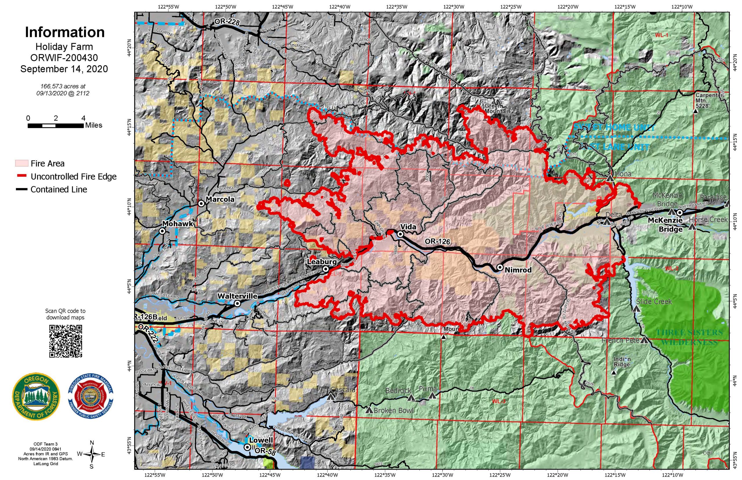
Springfield, Ore. – “Big iron stops fires, reinforced by the precision of crews digging hand lines,” said Jason Pettigrew, Operations Section Chief on ODF Incident Management Team 3.
This describes a good part of the suppression strategy being taken on the Holiday Farm Fire. The fire team is using bull dozers and other heavy equipment to construct control lines across large portions of the fire perimeter. Where the ground is too steep or rocky, fire fighters build hand lines to stitch together a solid perimeter of control lines. Structural crews continue to mop up hot spots around homes.
Solid work by firefighters combined with favorable weather conditions have led the Lane and Linn County Sheriffs to lower the evacuation levels in several areas.
The evacuation level for residents on Camp Creek, Upper Camp Creek, McKenzie Highway between Cedar Flats and Camp Creek have been downgraded from a Level 3 (GO NOW) to a Level 2 (BE SET).
The evacuation level for Deerhorn Road remains at Level 3 (GO NOW). Residents should be aware that the change to Level 2 (BE SET) reflects that fire danger has only subsided in that area enough to allow access to the area so they can make additional preparations for their homes, livestock or other animals. They should expect that if fire behavior increases these areas may return to Level 3 (GO NOW) and must be able to leave again at a moment’s notice.
Level 2 (BE SET) indicates significant danger to your area. Residents should either voluntarily relocate to a shelter or with family/friends outside of the affected area or be ready to evacuate at a moment’s notice. Emergency responders may not have time to provide you with additional notice if danger increases.
Please continue to monitor cell phones, landlines, local media and official information sources for evacuation updates.
Lane County: www.lanecounty.org/mckenziefire
Linn County: www.linnsheriff.org/fire_live_updates_sept_2020/
Structural assessment teams are working with the 80-person national urban search and rescue team (USAR). The teams are assessing structures and looking to locate unaccounted for people within the fire perimeter. This is a large-scale operation supported by OSFM structural resources.
Fire managers request that the public please avoid the area.
Roads are closed in the fire area and much of the Willamette National Forest (WNF) and Salem/Eugene BLM. Road hazards include falling trees and rocks and debris. For more information on closures on the WNF visit: https://www.fs.usda.gov/alerts/willamette/alerts-notices/?aid=61574
For more information on closures on the BLM visit: https://www.blm.gov/press-release/extreme-fire-activity-prompts-closure-bureau-land-management-lands-northwestern-oregon
Fire personnel are warmed by the community’s support but are unable to accept donations or use volunteers. The fire must use individuals with the appropriate qualifications. Those looking to volunteer or donate can connect with local organizations at: https://www.lanecounty.org/cms/one.aspx?pageId=17035134
| Estimated Size: |
166,573 |
| Containment: |
6% |
| Start Date/Time: |
9/7/2020, 8:20 p.m. |
| Expected Containment Date: |
10/29/2020 |
| Location: |
Lane County |
| Cause: |
Unknown |
| Personnel: |
745 |
| Assigned Resources:
Hand Crews:
Engines:
Dozers:
Water Tenders:
Other Heavy Equipment: |
19
48
25
13
2 |
| Assigned Aircraft:
Structure Task Forces: |
7
6 |
| Injuries: |
0 |
| Structures Threatened: |
23,456 |
| Structures Damaged: |
Assessing |
| Structures Destroyed: |
Unknown |
| Evacuations: |
Level 1 (READY), Level 2 (SET) and Level 3 (GO!) are in effect. |
September 14, 2020
Update for Sept. 14, 2020
Incident Commander: Mitch Ketron
Fire Information Line: 541-595-8227
Community Meetings: None planned
Incident Start Date: 9/8/2020
Cause: Unknown
Approximate Size (acres): 5,930
Containment: 0%
Location: Northeast of Diamond Lake Recreation Area
2 crews
1 helicopter
1 Engines
1 Dozers
5 Water Tenders
1 Masticators
Total Personnel: 150
Overview: Tuesday, September 8th, 2020, at approximately 8:30 AM, firefighters responded to a wildfire in the Mount Thielsen Wilderness. The fire began in the tree line near the Pacific Crest Trail within the Diamond Lake Ranger District. The east wind event caused the fire to run northwest and jump Highway 138 E. The Southern Area Incident Management Gray Team arrived Saturday, September 12th, to transition command from local resources on the Umpqua National Forest and give local units time to rest so they can respond to new fires.
Current Situation: Due to current weather conditions and smoke inversion over the local area, fire activity has moderated and has provided firefighters a great opportunity to gain ground in preparation and containment efforts. Emphasis is on keeping the fire footprint as small as possible, while protecting critical infrastructure within the immediate fire area.
Weather & Fire Behavior: A dry cold front is forecast to approach the region. Some light rain is possible along the coast but most of the region will remain dry. South to Southwest wind gusts coupled with low relative humidity is expected to bring critical fire weather. Forecasted weather conditions continue to challenge firefighters.
Air Quality and Smoke Impacts: The Oregon Department of Environmental Quality, Lane Regional Air Protection Agency and the Southwest Washington Clean Air Agency issued an air quality advisory Thursday for all regions of Oregon due to current wildfires. DEQ expects the air quality advisory to last until Monday afternoon. Smoke levels are fluctuating between unhealthy and hazardous in these areas. When smoke levels are hazardous, residents need to take steps to protect themselves including: avoiding outdoor activities, staying inside if possible, and using high efficiency particulate air (HEPA) filters. For more information, visit
www.Oregon.gov.
Evacuations: A Level 3 “GO” Evacuation Order remains in effect for all homes, cabins, recreation sites and the lodge at Diamond Lake.
Visit Douglas County Sheriff at
www.dcso.com for current evacuation information.
Visitor Information: Digit Point Lake Campground located on the Chemult Ranger District, Freemont Winema National Forest, remains open at this time and is not under an evacuation order. Campers are advised to check the areas they are interested in going to before entering. Visitors to the area should be mindful of posted speed limits when driving and watch out for firefighters, equipment, and emergency personnel.
Area Closures: Temporary emergency closure orders are in effect for all National Forest System lands, roads, and trails within the Cottage Grove Ranger District ORDER NO. 06-15-01-20-423, Tiller Ranger District ORDER NO. 06-15-02-20-422, Diamond Lake Ranger District ORDER NO. 06-15-03-20-420, and North Umpqua Ranger District ORDER NO. 06-15-06-20-421.
https://www.fs.usda.gov/alerts/umpqua/alerts-notices
Road Closures: Oregon Highway 138 East remains closed from the west end of Glide (Little River Road intersection, MP 17 at the Green Bridge) to the Oregon Hwy 230 (West Diamond Lake Highway, MP 83) junction. Only local traffic and emergency vehicles will be allowed through. For the latest road conditions, visit
https://www.tripcheck.com.
September 14, 2020
Update for Sept. 14, 2020, morning
Northwest Incident Management Team 9 (Incident Commander Brian Goff)
Phone: 971-334-7674 Hours: 7am-8pm
Email: 2020.archiecreek@firenet.gov
InciWeb: https://inciweb.nwcg.gov/incident/7176/
Facebook: https://www.facebook.com/Archie-Creek-Fire-Information-120244459815292/
Evacuations, shelter areas: Douglas County Sheriff website www.dcso.com/evacuations and Facebook page at https://www.facebook.com/DouglasCoSO/
Fire summary:
Favorable weather conditions yesterday resulted in another day of decreased fire activity on the Archie Creek Fire.
Containment lines along the western flank of the fire were held in check from the South Fork of Calapooya Creek, down to Glide. Active fire moved toward primary lines on the south River Road area and on the east. Firefighters stayed late to burnout and contain fire on the south.
Fire crews continue working to reinforce primary and secondary containment lines. They are using a combination of existing road systems and new dozer lines to check the fire’s spread. Structure protection resources remain in place area.
Firefighters and crews from the Oregon Department of Transportation and Pacific Power continue work along Highway 138E by cutting hazard trees, checking downed power lines and removing debris from the roadway. The highway remains closed to all non-fire personnel. See www.tripcheck.com for current road closures. Road clearing operations also continued on Rock Creek Road.
Construction of direct and indirect line will continue today, along with holding and mopping up completed line. Firefighters will continue to assess opportunities to exclude acres when possible. Air resources are available should the smoke clear enough to make flying safe.
Temperatures and humidity today will be slightly higher than yesterday, with variable winds, shifting direction through the day. Smoke will continue to hang over lower elevations.
Safety for firefighters, emergency workers and the public is our number one priority. Road and area closures in and around the Archie Creek Fire remain in place while firefighters continue suppression and control efforts. The Archie Creek Fire has burned 121,379 acres and remains 10% contained. There are 556 personnel assigned to the fire. Additional resources are expected to arrive today. More are on order.
Yesterday, 255 residents of certain areas of the Glide and Idleyld Park communities, which were impacted by the Archie Creek Fire, attended a meeting to learn about the status of their home. In total, 109 residences have been identified as lost as a result of the fire. The specific locations of the losses are not being released at this time. Thus far, there have been no reports of fatalities or missing persons made to the Sheriff’s Office. Our heartfelt sympathies go out to all those who have been displaced and negatively impacted by this fire. Donations to fire victims may be dropped off at the Glide Baptist Church; or donate through the American Red Cross or Salvation Army.
Air quality: The Oregon Department of Environmental Quality at http://www.oregon.gov/deq
Road closures: Monitor www.tripcheck.com for updates on the highway closures.
Umpqua National Forest closures: Maps and closure orders can be found on Inciweb at: https://inciweb.nwcg.gov/incident/closures/7176/. Additional information on the Forest Service closures are available at: https://www.fs.usda.gov/alerts/umpqua/alerts-notices managed lands east of Interstate 5, within the Swiftwater Resource Area are closed.
September 14, 2020
Update for Sept. 13, 2020, evening
Northwest Incident Management Team 9 (Incident Commander Brian Goff)
Phone: 971-334-7674 Hours: 7am-8pm
Email: 2020.archiecreek@firenet.gov
InciWeb: https://inciweb.nwcg.gov/incident/7176/
Facebook: https://www.facebook.com/Archie-Creek-Fire-Information-120244459815292/
Evacuations, shelter areas: Douglas County Sheriff website www.dcso.com/evacuations and Facebook page at https://www.facebook.com/DouglasCoSO/
Favorable weather conditions resulted in another day of decreased fire activity on the Archie Creek Fire.
Containment lines along the western flank of the fire were held in check from the South Fork of Calapooya
Creek, down to Glide. Crews continue working in the area to reenforce primary and secondary containment
lines. In the Little River area, crews are utilizing a combination of existing road systems and new dozer lines
to check the fires spread. Structure protection resources remain in place throughout the Little River area.
Air operations were grounded for another day due to smoky conditions in the region. The Archie Creek Fire
has burned 121,379 acres and remains 10% contained.
Crews from the Oregon Department of Transportation and Pacific Power continue work along Highway 138E
by cutting hazard trees, checking downed power lines and removing debris from the roadway. The highway
remains closed to all non-fire personnel from mile marker 21 through to the Highway 97 junction. Road
clearing operations also continued on Rock Creek Road.
Safety for our firefighters and the public remains our number one priority. Road and area closures in and
around the Archie Creek Fire remain in place while firefighters continue suppression efforts.
September 13, 2020
Facebook updates: https://www.facebook.com/UmpquaNationalForest
Acres: 5,100
Containment: 0%
Location: 2 mi S of Diamond Lake
September 13, 2020
Update for Sept. 13, 2020, morning
Incident Commander: Oregon State Fire Marshal’s Blue Team Scott Magers
JACKSON COUNTY, Ore. – As of this morning, the Almeda Fire had minimal growth and is currently 60 percent contained.
Fire crews continue to focus their efforts inside the fire line to mitigate hazardous conditions which include fire debris, unstable structures, downed utility lines, as well as venting natural gas lines.
We continue to urge all citizens to stay away from evacuation zones as crews actively work to address hazardous conditions.
Temperatures are expected to reach the mid 80s today and remain for the next several days. Air quality conditions are hazardous. There is a red flag warning in effect from 3:00 to 8:00 p.m. today. During this time, winds will be west to northwest 10 to 15 mph with gusts up to 25 mph.
As the Almeda Fire transitions to a more stabilized phase of the incident, we have begun to plan for the recovery phase. A hazardous materials team will be arriving from Coos County as well as an Urban Search and Rescue Team with members from Utah and Nevada. These 2 teams will be assisting with damage assessment, hazard mitigation as well as detailed searches.
Persons with respiratory illnesses should remain indoors to avoid inhaling smoke. If driving, slow down, use your headlights, and leave plenty of distance ahead of you. Visit Oregon Health Authority’s dedicated webpage for health resources related to wildfire smoke.
The health and safety of Rogue Valley communities and fire crews continues to be our top priority. Our best management practices include a zero-tolerance policy for proper COVID-19 PPE, proper distancing and minimizing our physical interactions within the community.
Shelter for homeowners affected by the fire can contact the Jackson County Expo at 541-774-8270.
September 13, 2020
Update for Sept. 13, 2020, morning
Follow updates on the North Bank Lane Fire on Coos Forest Patrol Association’s (CFPA) facebook.
COQUILLE, Ore. – The N Bank Fire MM8 fire is steady and still holding at 350 acres, very minimal wind and moderate RH recovery. The fire sits at 50% containment. There is a full force of resources on the fire again today. Crews are working hard on the containment lines and removing or minimizing the hazards on the fire. Wet lining continues around the perimeter. Our TFR expired today. The road remains closed. Thank you to all of you for your continued support and understanding of the inconveniences you are facing at this time.
September 13, 2020
Update for Sept. 13, 2020, morning
Incident Commander: CAIIMT10, Dalrymple
HAPPY CAMP, CALIFORNIA — The Slater Fire continues to slowly spread in all directions, moderated by cool, moist weather in low-lying areas. The Devil Fire remains unstaffed, but Team 10 is scouting containment opportunities. Additional firefighting resources are on order.
North side: A virtual public meeting will be held today, September 13, 2020 at 2:30 p.m.
Slater Fire North Area Virtual Community Meeting
Facebook Live www.facebook.com/SlaterAndDevilFireInformation
South side: A virtual meeting public will be held today, September 13, 2020 at 4 p.m.
Slater Fire South Area Virtual Community Meeting
Facebook Live www.facebook.com/SlaterAndDevilFireInformation
Fire activity around Happy Camp has now significantly moderated, with humidity damping down fire activity along the fire perimeter there. The town remains in mop-up and patrol status, with crews falling hazard trees and power companies working diligently to restore infrastructure so that displaced residents can return as soon as it’s safe.
The Slater Fire has now backed down to Highway 96 near Seattle Creek, where firefighters have built handline to limit fire growth potential and keep the fire north of the highway. A firing operation is planned to strengthen an indirect line protecting residences north of Happy Camp along the Highway 96 corridor, creating a solid containment line along the highway. Meanwhile, protection is underway around structures and utilities from Thompson Creek east (and downriver) to Fort Goff. Firefighters are also performing prep work from China Creek to Thompson Creek in case the fire arrives there.
Near Gasquet, crews focused on structure protection and scouting for areas to engage. The fire is currently hung up at Oregon Mountain Road and backing into Knopki Creek, with not much movement observed on the SW edge. A local crew, the Smith River Hotshots, have been assigned to the Slater Fire.
Along the west side of the fire, Siskiyou Mountain Ranger District initial attack firefighting resources have begun to prep the 1040 road in the event that the Devil Fire should work its way out of the Red Buttes Wilderness. Portions of the 1040 road were treated in 2017 during the Miller Complex. Along with increased humidity, the Miller Complex Fire scar should slow or stop fire spread towards the Applegate Valley. The Slater fire has not made it into Steve’s Fork; fire personnel scouted the area several days ago and completed a full reconnaissance before the smoke settled in. The Slater Fire is currently eight to ten miles from Williams, Oregon. Firefighting resources are scouting for the best places to put in direct, indirect and contingency lines to protect communities in this area. Firefighters are preparing Oregon Caves National Monument to protect it from the Slater Fire.
Winds out of the east have caused smoke impacts from the Slater and Devil Fires that have extended to the coast. Smoke continues to impact most of the west coast due to multiple large fires. The cool, wet smoke inversion is likely to remain into this afternoon, forecasts say. The inversion could begin mixing up into the atmosphere later this afternoon or tomorrow. Meanwhile, winds today are blowing 15 miles per hour on ridgetops. This could affect fire behavior at higher elevations in the Slater Fire’s interior and on the Devil Fire.
Both fires are still zero percent contained, burning mainly in timber, logging slash and brush. The Devil Fire is estimated at 4,149 acres. The Slater Fire is estimated at 126,333 acres, according to last night’s infrared flight.
Due to extreme fire danger, all National Forests in California have been closed from September 9 through 14, 2020. More details on these closure orders, along with fire restrictions orders, can be found on National Forest websites and on InciWeb. Highway 199 remains closed from O’Brien south almost to Gasquet. Highway 96 remains closed from Portuguese Creek to Clear Creek.
EVACUATION INFORMATION:
September 13, 2020
Update for Sept. 13, 2020, morning
Oregon Department of Forestry IMT 3 Link Smith, Incident Commander and Oregon State Fire Marshal’s Red Team Ian Yocum, Incident Commander
Holiday Farm Fire Information: 541-357-9729 (7am-10pm)
Lane County Non-Emergency Call Center: 541-682-3977 (7am-10pm)
Linn County Non-Emergency Call Center: 541-812-2260
Facebook: https://www.facebook.com/HolidayFarmFire/
Email: holidayfarmfireinfo@gmail.com
Springfield, Ore. – The hard work of wildland and structural firefighters on the Holiday Farm Fire east of Springfield is starting to pay off. Yesterday, the Lane County Sheriff’s Office lowered the evacuation level in the Mohawk Valley to 2 (BE SET). After several days with zero containment, fire managers now estimate containment at five percent. Containment reflects the fire managers’ confidence that existing control lines would prevent additional fire spread.
An infrared flight that usually takes place overnight to show changes in fire growth did not occur last night. The most current information estimates the fire perimeter at 161,826 acres.
Many residents in the Mohawk Valley and north of the Linn County line are affected by the drop in evacuation levels. Please note two important exceptions:
- West of Marcola Road south of the intersection with Hill Rd. is being downgraded from a Level 2 (BE SET) to a Level 1 (BE READY).
- East of the Mohawk River from Wendling Rd. to the Linn county line remains at Level 3 (GO NOW), including Wending Road, Paschelke Road, Hileman Road, Bunker Hill Road and Mohawk River Road and their connecting roads.
The evacuation level along Highway 126 from Thurston Road to Camp Creek Road, including Camp Creek Road, Upper Camp Creek Road and Cedar Flat Road is also being downgraded from a Level 3 (GO NOW) to a Level 2 (BE SET). All of Deerhorn Road remains in a level 3 evacuation.
Please note that dropping Level 3 (GO NOW) to Level 2 (BE SET) reflects that fire danger has subsided in that area enough to allow residents access to the area so they can make additional preparations for their homes, livestock or other animals. They should expect that if fire behavior increases these areas may return to Level 3 (GO NOW) and residents must be able to leave again at a moment’s notice.
Structural assessment continues today as crews are joined by an 80-person national urban search and rescue team (USAR). The USAR team will be working to locate unaccounted for people within the fire perimeter and start assessing structures. This will be a large-scale operation.
Crews dedicated to protecting structures yesterday made good progress along the Highway 126 corridor. They continued to improve fire protection for homes throughout the fire and executed mop up operations in the southwest portion of the fire, specifically in Goodpasture Loop and Deerhorn Road.
With more resources in place, fire crews have been able to construct direct control lines (adjacent to the fire’s edge) and indirect control lines (farther back from the fire’s edge). Firefighters completed a successful burnout operation in the southwestern corner of the fire to establish a solid control line. Additionally, crews have been mopping up, scouting locations for new control lines and removing snags to make areas safer for fire personnel and vehicles.
Structural firefighters continue to focus on protecting structures and mopping up around homes. Currently, the fire threatens 23,456 structures.
Fire managers request that the public please avoid the area. Some roads are closed in the fire area and much of the Willamette National Forest (WNF). Road hazards include falling trees and rocks and debris. For more information on closures on the WNF visit: https://www.fs.usda.gov/alerts/willamette/alerts-notices/?aid=61574
Many communities in Lane and Linn counties remain under Level 1, 2 or 3 evacuation orders.
Level 2 (BE SET) means there is significant danger to your area and residents should either voluntarily relocate to a shelter or with family/friends outside of the affected area and be ready to evacuate at a moment’s notice. Emergency responders may not have time to provide you with additional notice if danger increases.
Please continue to monitor cell phones, landlines, local media and official information sources for evacuation updates. Current evacuation levels can be found at:
Lane County: www.lanecounty.org/mckenziefire
Linn County: www.linnsheriff.org/fire_live_updates_sept_2020/
Fire personnel are warmed by the community’s support but are unable to accept donations or use volunteers. The fire must use individuals with the appropriate qualifications. Those looking to volunteer or donate can connect with local organizations at: https://www.lanecounty.org/cms/one.aspx?pageId=17035134
| Estimated Size: |
161,826 acres (no IR flight yesterday) |
| Containment: |
5% |
| Start Date/Time: |
9/7/2020, 8:20 p.m. |
| Expected Containment Date: |
10/29/2020 |
| Location: |
Lane County |
| Cause: |
Unknown |
| Personnel: |
628 |
| Assigned Resources:
Hand Crews:
Engines:
Dozers:
Water Tenders:
Other Heavy Equipment: |
16
45
6
13
2 |
| Assigned Aircraft:
Structure Task Forces: |
4
5 |
| Injuries: |
0 |
| Structures Threatened: |
23,556 |
| Structures Damaged: |
Assessing |
| Structures Destroyed: |
Unknown |
| Evacuations: |
Level 1 (Ready), Level 2 (Set) and Level 3 (GO!) are in effect. |
September 13, 2020
Northwest Incident Management Team 9 (Incident Commander Brian Goff)
Phone: 971-334-7674 Hours: 7am-8pm
Email: 2020.archiecreek@firenet.gov
InciWeb: https://inciweb.nwcg.gov/incident/7176/
Facebook: https://www.facebook.com/Archie-Creek-Fire-Information-120244459815292/
Evacuations, shelter areas: Douglas County Sheriff website www.dcso.com/evacuations and Facebook page at https://www.facebook.com/DouglasCoSO/
Fire information: The Archie Creek Fire burning east of Roseburg is 121,379 acres. Containment is now 10%. The fire is burning in the North Umpqua drainage on the west slope of the Cascades. There are 539 personnel assigned to the fire. Additional resources are expected to arrive today. More are on order.
Current Situation: Fire fighter and public safety is the number one priority. Access to fire areas is limited due to smoke and blocked roads. Large tracts of private and federal timber lands continue to be threatened. Electrical transmission lines are damaged or are threatened. Recreation areas and resorts are closed due to the fire. There are evacuation orders in effect. Residents in several areas will be able to find out about their property at a public meeting today at the Glide High School, not a virtual meeting. (see From the Douglas County Sheriff).
Yesterday, firefighters assigned to the fire worked with local fire departments, industrial landowners and loggers on structure protection and creating containment lines around the fire perimeter. Most of the work was on the western flank of the fire between the Little River and the Nonpareil areas.
Air operations were grounded due to thick smoke. Crews from the Oregon Department of Transportation (ODOT) and fire crews are working to get Hwy 138E safe for fire traffic only at this time. The highway is closed to all non-fire traffic between Milepost 17 and the junction with Hwy 97.
Today, direct and indirect fire line construction will continue. Crews will continue to hold and mopup completed line. Direct dozer line construction will continue on the western and southern flanks of the fire where practical and where topography will allow. Firefighters will assess opportunities to exclude acres when possible. Several crews will continue to work late into the night. There are three medium helicopters and one light helicopter available and an aerial assessment of the fire will be completed if smoke clears.
Weather/fire behavior: Warm and dry conditions, along with breezy winds, will persist today. Smoke over Roseburg is likely to begin lifting today which may lead to increased fire activity. Overnight humidity will increase, but daytime humidity will remain quite low at higher elevations. Large and medium size fuels remain very dry, but overnight humidity has helped fine fuels.
From the Douglas County Sheriff: The Sheriff’s Office will hold a private informational drop-in meeting today, from 3 to 7 pm at the Glide High School. This meeting is for residents of areas listed below who want to learn more about residential structural damage to their property and resources available to them. The meeting will be open ONLY to residents of: Moore Hill Lane, Susan Creek Road, Star Mountain Lane, Smith Springs Lane, Evergreen Springs Lane, Hone Creek Road, Tioga Lane, Rock Creek Road (all side roads), North Umpqua Hwy from Rock Creek Road to Steamboat, Klahanie Lane, Skyview Drive, Lone Rock Road, South Lone Rock Road, Bar L Ranch Road (all side roads), Terrace Drive, Upper Terrace Lane, Mystic Mountain Lane, Evergreen Lane.
For further information:
Air quality: The Oregon Department of Environmental Quality at http://www.oregon.gov/deq
Road closures: Monitor www.tripcheck.com for updates on the highway closures.
Umpqua National Forest closures: Maps and closure orders can be found on Inciweb at: https://inciweb.nwcg.gov/incident/closures/7176/. Additional information on the Forest Service closures are available at: https://www.fs.usda.gov/alerts/umpqua/alerts-notices managed lands east of Interstate 5, within the Swiftwater Resource Area are closed.
September 12, 2020
Medford, Ore. – The U.S. National Weather Service in Medford, Oregon, has issued a Red Flag Warning for Sunday, Sept. 13, 2020. Due to the warning, all current Level 2 and Level 3 orders will remain in place. The rest of Jackson County is now on Level 1 “Be Ready.” Residents should be aware of the fire risk that exists; monitor emergency services websites and local media outlets for information and updates.
Follow Jackson County evacuations.
September 12, 2020
Fire managers will be hosting a virtual community meeting via Facebook Live on the fire’s Facebook page at 7:00 pm this evening. The virtual event will also be available at: https://www.facebook.com/events/326383102027295
Springfield, Ore. – We are saddened to report that firefighters located a deceased person in a home within the fire area yesterday. First responders are working with the Medical Examiner’s Office to identify the deceased, which may take some time. After the person has been identified, Lane County Sheriff’s Office will notify next of kin and afford them the opportunity to notify additional family and friends prior to releasing the person’s name.
Today, firefighters will begin the process of trying to locate unaccounted for people within the fire perimeter and start assessing structures. Teams will start along Highway 126 and the nearby communities. If any victims are found, the firefighters will notify the Lane County Sheriff’s Office for investigation.
Yesterday, the fire grew by about 5,000 acres, raising the total to 161,826 acres. The fire perimeter is nearly 200 miles. It remains 0% contained. Calmer weather over the fire moderated fire behavior, although a few spots fire were reported and quickly controlled. A stubborn layer of thick smoke has hampered air operations but aircraft remain available if conditions improve.
With more resources in place, fire crews have been able to construct direct control lines (adjacent to the fire’s edge) and indirect control lines (farther back from the fire’s edge). Firefighters completed a successful burnout operation in the southwestern corner of the fire to establish a solid control line. Additionally, crews have been mopping up, scouting locations for new control lines and removing snags to make areas safer for fire personnel and vehicles.
Structural firefighters continue to focus on protecting structures and mopping up around homes. Currently, the fire threatens 17,732 structures.
Fire managers request that the public please avoid the area. Some roads are closed in the fire area and much of the Willamette National Forest (WNF). Road hazards include falling trees and rocks and debris. For more information on closures on the WNF visit: https://www.fs.usda.gov/alerts/willamette/alerts-notices/?aid=61574
Many communities, in Lane and Linn counties remain under Level 1, 2, or 3 evacuation orders. Current evacuation information can be found at:
Lane County: www.lanecounty.org/mckenziefire
Linn County: www.linnsheriff.org/fire_live_updates_sept_2020/
Fire personnel are warmed by the community’s support but are unable to accept donations or use volunteers. The fire must use individuals with the appropriate qualifications. Those looking to volunteer or donate can connect with local organizations at: https://www.lanecounty.org/cms/one.aspx?pageId=17035134
| Estimated Size: |
161,826 acres |
| Containment: |
0% |
| Start Date/Time: |
9/7/2020, 8:20 p.m. |
| Expected Containment Date: |
10/29/2020 |
| Location: |
Lane County |
| Cause: |
Unknown |
| Personnel: |
538 |
| Assigned Resources:
Hand Crews:
Engines:
Dozers:
Water Tenders:
Other Heavy Equipment: |
11
61
15
6
2 |
| Assigned Aircraft:
Structure Task Forces: |
4
5 |
| Injuries: |
0 |
| Structures Threatened: |
17,732 |
| Structures Damaged: |
Assessing |
| Structures Destroyed: |
Unknown |
| Evacuations: |
Level 1 (Ready), Level 2 (Set) and Level 3 (GO!) are in effect. |
September 12, 2020
Updated Sept. 12, 2020, 2:30 p.m.
All ODF-managed lands are closed for public use. Public use closures of the Tillamook and Clatsop state forests, along with ODF-managed lands in Benton, Lincoln & Polk counties, have been extended past Sunday, Sept. 13, and remain closed until re-openings are announced publicly. All other ODF-managed lands remain closed until further notice.
September 12, 2020
September 12, 2020
Update for Sept. 12, 2020 – Corrected
Northwest Incident Management Team 9 (Incident Commander Brian Goff)
Email: 2020.archiecreek@firenet.gov
Phone: 971-334-7674 Hours: 7am-8pm
InciWeb: https://inciweb.nwcg.gov/incident/7176/
Facebook: https://www.facebook.com/Archie-Creek-Fire-Information-120244459815292/
Fire information: The Archie Creek Fire burning east of Roseburg is now 115,857 acres and is at 0% containment. It is burning in the North Umpqua drainage on the west slope of the Cascades. There are 369 people assigned to the fire.
Current Situation: Fire fighter and public safety is the number one priority. Access to fire areas are limited due to smoke inversion and blocked roads. Large tracts of private and federal timber lands continue to be threatened. Electrical transmission lines are damaged or are threatened. Recreation areas and resorts are closed due to the fire.
Progress is being made with structure assessments, protection of structures, use of roads, power infrastructure, containment of fire, and opportunities for future containment. Additional resources are coming to help. It takes time with resources spread thin and changing weather to have confidence to claim containment.
Yesterday, firefighters worked on the fire with local fire departments, industrial landowners and loggers to construct fire lines and provide structure protection. Oregon Department of Transportation (DOT) and fire crews worked to clear fallen trees and large rocks from Hwy 138 East and Rock Creek Road.
Indirect fire line construction will continue today. Direct dozer line construction will continue on the western and southern flanks of the fire where practical and where topography will allow.
Northwest IMT 9 (I.C. Goff) is managing the fire in coordination with the Umpqua National Forest, the Roseburg Bureau of Land Management (BLM), the Douglas Forest Protective Association (DFPA), the Douglas County Sheriff’s Office, Search and Rescue, local fire departments and local logging companies.
Weather: Warm and dry conditions, along with breezy afternoon winds, will persist through the weekend. Smoke may limit daytime highs. Humidity should improve over the next few days, especially overnight recoveries, but daytime humidity will remain quite low at higher elevations.
Current Evacuations:
LEVEL 1 “BE READY” – All Douglas County residents should be ready to leave at all times.
LEVEL 2 “BE SET” –
- Nonpareil Road from Plat K Road west to Gassy Creek
- The community of Glide from the Green Bridge east to Little River Road. (Except for Lone Rock Road, Bar L Ranch Road, Upper Terrace, Terrace, Little River Road)
LEVEL 3 “GO!” –
- Dry Creek (Happy Creek Ln, Felix Flat, Elk Ridge, Illahee) Steamboat Creek to the Green Bridge in Glide (Includes all addresses between these points, Includes the community of Idleyld Park)
- Lone Rock Road
- Bar L Ranch Road
- Upper Terrace Drive
- Terrace Drive
- Little River Road
- Gassy Creek Road east to the end of Nonpariel Road
Shelter: Douglas County has an evacuation location for displaced wildfire residents, pets and livestock at the Fairgrounds. For information about space availability, contact the Fairground Office at 541-440-4394. For information on shelter for horses and large animals, contact the Douglas County Parks Department at 541-440-6040. For small animals (cats, dogs, birds, etc.), contact Saving Grace at 541-672-3907. For other small animals like pigs, sheep or goats, contact the Douglas County Fairgrounds.
The American Red Cross, working in conjunction with the Salvation Army, has set up an Emergency Shelter in Douglas Hall at the Douglas County Fairgrounds. For more information, please contact the Salvation Army at (541) 672-6581 and the American Red Cross at (541) 344-5244.
Safety of evacuated areas: Douglas County deputies and troopers from the Oregon State Police are patrolling residential areas in an effort to deter and detect criminal activities during the evacuation period. Residents who have video surveillance or cameras, should call and report any suspicious activity they observe.
The Sheriff’s Office has created a page on its website which contains maps of the current evacuation zones. The maps attempt to provide a visual of the most current evacuation zones by showing roads and specific addresses in some cases. The maps can be found at www.dcso.com/evacuations and are updated as quickly as possible.
Air quality: The Oregon Department of Environmental Quality has issued an Air Pollution Advisory for today. For more information, visit http://www.oregon.gov/deq.
Closures: Highway 138 East remains closed to non-fire traffic between Milepost 17 and 47. Motorists are advised to use alternative routes and to monitor www.tripcheck.com for updates on the highway closure.
Bureau of Land Management (BLM) – lands east of Interstate 5, within the Swiftwater Resource Area are closed.
Umpqua National Forest – the entire Umpqua National Forest is closed until the extreme fire danger is over, except for emergency personnel and persons that have a permit specifically authorizing their presence in the closure areas. These closures are to protect the public from the hazardous conditions on the ground and to decrease the chance of additional human caused fires. Also, chainsaw use on the Forest is prohibited.
Forest Service roads affected by the fire are being cleared by agency and fire personnel. State, county and other local jurisdiction roads remain under the direction of the specific agency.
Maps and closure orders can be found on Inciweb at: https://inciweb.nwcg.gov/incident/closures/7176/. Additional information on the Forest Forest Service closures are available at: https://www.fs.usda.gov/alerts/umpqua/alerts-notices.
September 12, 2020
Update for Sept. 12, 2020
Follow updates on the North Bank Lane Fire on Coos Forest Patrol Association’s (CFPA) facebook.
COQUILLE, Ore. – Good morning all, the North Bank MM8 fire is holding steady. We are at about 35% containment and the fire has no new growth and remains at 350 acres. The fire still has a full force of resources. Continuing work on fire control lines, started wet lines around the fire yesterday afternoon, and continuing work on removing any hazards on the fire. This fire is looking real good, no spotting, no new fire activity.The road remains closed.
September 11, 2020
Follow updates on the North Bank Lane Fire on Coos Forest Patrol Association’s (CFPA) facebook.
COQUILLE, Ore. – The N Bank Rd MM8 Fire is holding. No new growth or activity on the fire. There was RH recovery and little to no wind on the fire through the night. The fire remains at 350 acres with a full force of resources. The crews are working on containment lines and removing hazards. Mop up should begin soon. The N Bank Rd remains closed from Bandon side to Coquille side.
Containment: 30%
September 11, 2020
Springfield, Ore. – Firefighters have been working to protect structures, as well as establish control lines on the Holiday Farm Fire. At 156,708 acres in size, the fire is currently 0% contained. Other priorities include clearing roads, such as Highway 126 for responder access to the area. Yesterday the weather was more favorable to firefighting operation. Winds decreased to 5-10 mph and the relative humidity was slightly higher than recent days.
Structural crews used the break to establish defensible space around communities, helping to keep these values safe. Structural and wildland resources have been working in tandem to keep the fire away from homes and businesses. There are currently 17,732 structures threatened by this fire.
425 personnel are now assigned to the fire. Resources continue to be spread thin across the region and the nation, as many areas have large fire activity. Local resources, such as cooperators with heavy equipment have been dispatched to this incident to begin assisting in the battle. In addition, members of the Oregon National Guard are here and will be staffing checkpoints on the roads so that sheriff’s deputies are free to patrol neighborhoods.
Today’s weather calls for poor humidity recovery in higher elevations. Firefighters have been asked to stay watchful for the potential of the inversion layer lifting (blanket of smoke), which could cause a more dynamic fire environment with more active fire behavior.
Public and firefighter safety remains the highest priority. Fire managers are asking the public to please avoid the fire area. Roads are closed throughout the fire to give firefighters room to work and to keep the public safe. Fire weakened trees, ash pits, and falling rocks and other debris are just some of the hazards on the incident. Many communities, in both Lane and Linn counties remain under Level 1, 2, or 3 evacuation orders. Current evacuation information can be found at:
Lane County: www.lanecounty.org/mckenziefire
Linn County: www.linnsheriff.org/fire_live_updates_sept_2020/
Fire personnel are touched by the outpouring of support from the community. Unfortunately, all resources are ordered through dispatch systems, and volunteers cannot be utilized. The fire must utilize individuals with appropriate qualifications. No donations can be accepted by fire personnel. People looking to volunteer or donate are encouraged to look at local organizations such as American Red Cross or United Way, who will be aiding displaced residents.
Air quality is expected to remain at very unhealthy levels throughout the region today. Individuals are encouraged to avoid prolonged exposure to the outdoors or heavy exertion while outdoors.
| Estimated Size: |
156,708 |
| Containment: |
0% |
| Start Date/Time: |
9/7/2020, 8:20 p.m. |
| Expected Containment Date: |
10/29/2020 |
| Location: |
Lane County |
| Cause: |
Unknown |
| Personnel: |
425 |
| Assigned Resources:
Hand Crews:
Engines:
Dozers:
Water Tenders:
Other Heavy Equipment: |
6
49
12
11
2 |
| Assigned Aircraft:
Structure Task Forces: |
0
5 |
| Critical Resources Needs:
Injuries: |
Type 2 Crews, Type 4,5,6 Engines, Aircraft, Overhead
0 |
| Structures Threatened: |
17,732 |
| Structures Damaged: |
Assessing |
| Structures Destroyed: |
Unknown |
| Evacuations: |
Level 1 (Ready), Level 2 (Set) and Level 3 (GO!) are in effect. |
September 11, 2020
Fire Update: Friday, Sept. 11, 2020, AM
Public briefing: Archie Creek Fire Officials will hold a virtual public briefing today, Friday, Sept. 11, 2020 at 2:00 pm. This will be a live stream video information briefing regarding the fire affecting several communities in Douglas County. Please check the Archie Creek Fire Information Facebook page for a link to the live video beginning at 1:55 pm. The briefing will begin at 2:00 pm.
Northwest Incident Management Team 9 (Incident Commander Brian Goff)
Email: 2020.archiecreek@firenet.gov
Phone: 971-334-7674, Hours: 7am-8pm
InciWeb: https://inciweb.nwcg.gov/incident/7176/
Current Situation: The Archie Creek Fire burning east of Roseburg is now 115,857 acres with 0% contained. It is burning in the North Umpqua drainage on the west slope of the Cascades. Today fire managers will continue assessment of the fire. They are working with local fire departments on structural protection and fire line construction as weather conditions allow.
Line construction continues on west and southwest flanks, utilizing heavy equipment in cooperation with local timber companies. ODOT is working to clear Highway 138 E for fire traffic only. Pacific power is working to restore and protect lines and infrastructure. Structural fire departments are working directly with residents and on damage assessments.
Fire fighter and public safety is a concern and access to fire areas is limited at this time due to smoke inversion and blocked roads. Residences and commercial properties continue to be evacuated. Large tracts of private and federal timber lands continue to be threatened. Electrical transmission lines are damaged or are threatened. Forest recreation areas are impacted. Recreational resorts are closed due to the fire.
Northwest Team 9 (I.C. Goff) is working with the Umpqua National Forest, the Roseburg Bureau of Land Management (BLM), Douglas Forest Protective Association (DFPA), Douglas County Sheriff’s Office, Search and Rescue, local fire departments and local loggers.
Weather: Extreme fire weather conditions will continue to hamper suppression. Low humidity, high temperatures and high winds continue to create extreme fire conditions. Smoke inversion limits use of aerial resources. Humidity is expected to increase over the weekend, with possible rain early next week.
Current Evacuations:
LEVEL 1 “BE READY”: ALL DOUGLAS COUNTY RESIDENTS SHOULD BE IN THIS LEVEL OF READINESS AT ALL TIMES.
LEVEL 2 “BE SET:” Nonpareil Road 4400-7500 block (Including Fair Oaks Road, Fraser Canyon, Bonanza Mine, Plat K)
LEVEL 3 “GO!”: LEAVE IMMEDIATELY!
- Dry Creek (Happy Creek Ln, Felix Flat, Elk Ridge, Illahee)
- Steamboat Creek to Little River Road in Glide (Includes all addresses between these points, Includes the towns of Idleyld Park and Glide)
- All of Little River Road
- The end of Nonpareil Road west to Banks Creek Road
Shelter: Douglas County has an evacuation location for displaced wildfire residents, pets and livestock. Information about space availability at the Fairgrounds, contact the Fairground Office at 541-440-4394. For information on shelter for horses and large animals, contact the Douglas County Parks Department at 541-440-6040. For small animals (cats, dogs, birds, etc.), contact Saving Grace at 541-672-3907. For other small animals like pigs, sheep or goats, contact the Douglas County Fairgrounds for space information.
The American Red Cross, working in conjunction with the Salvation Army, has set up a temporary Emergency Shelter in Douglas Hall at the Douglas County Fairgrounds. For more information, please contact the American Red Cross and the Salvation Army directly. You can reach the Salvation Army at (541) 672-6581 and the American Red Cross at (541) 344-5244.
Safety of evacuated areas: Douglas County deputies and troopers from the Oregon State Police are patrolling residential areas in an effort to deter and detect criminal activities during the evacuation period. Residents who have video surveillance or cameras, should call and report any suspicious activity they observe.
The Sheriff’s Office has created a page on its website which contains maps of the current evacuation zones. The maps attempt to provide a visual of the most current evacuation zones by showing roads and specific addresses in some cases. The maps can be found at www.dcso.com/evacuations and are updated as quickly as possible.
Air quality: The Oregon Department of Environmental Quality has issued an Air Pollution Advisory for today. For more information, visit http://www.oregon.gov/deq
Closures: Highway 138 East remains closed to non-fire traffic between Milepost 17 and Highway 97 junction. Motorists are advised to use alternative routes and to monitor www.tripcheck.com for updates on the highway closure.
All Bureau of Land Management (BLM) managed lands, east of Interstate 5, within the Swiftwater Resource Area are closed.
Umpqua National Forest lands in the fire area are also closed. See https://inciweb.nwcg.gov/incident/7176/ for updates.
September 11, 2020
Update for Sept. 11, 2020, 9 a.m.
HAPPY CAMP, CALIFORNIA — 9 a.m. Today, firefighting forces on the Slater Fire are focused on protection of buildings and utilities, development of a perimeter containment strategy, and supporting local fire units in initial attack on both sides of the state line as needed. Reports from the field indicate that no additional structures were lost yesterday.
For the additional information, including information on any potential evacuations, visit the following sites:
Current evacuation orders are posted on Siskiyou County Sheriff’s Office Facebook page at www.facebook.com/SiskiyouCountySheriff/.
For Josephine County evacuation information, go to www.facebook.com/jcsosheriff, or https://www.co.josephine.or.us/Page.asp?NavID=1858
InciWeb https://inciweb.nwcg.gov/incident/7173/