September 10, 2020
HAPPY CAMP, CALIFORNIA—The Slater Fire started the night of September 7, near Slater Butte Fire Lookout, on the Klamath National Forest. California Incident Management Team 10 assumed command of the incident at 6 a.m. today. This fire has burned 120,000 acres to date.
Fire-weather conditions today are expected to be similar to the past few days. Hot temperatures with dry unstable air and record low fuel moistures could result in more extreme fire behavior, fire spread in all directions, and plume-dominated fire activity.
Point protection of structures in threatened communities of Happy Camp, O Brien, Takilma, Cave Junction, and Gasquet remains the top priority for the Team. Hot weather, drought-stressed, dry fuels and extreme fire behavior resulted in power outages, road closures, and evacuations for impacted communities on both sides of the California-Oregon border.
With a record number of fires across the West, resources are stretched thin nationally. This resource shortage forces the incoming team to triage, and to develop a fire suppression strategy with what limited resources are available. Firefighters have been working non-stop since initial attack, employing what few resources they have. Air resources will be utilized for reconnaissance and fire suppression as smoke and visibility permit.
A heat-detection flight yesterday showed a second fire burning east of the Slater Fire. Estimated at 500 acres as of this morning, the Devils Fire is currently unstaffed and uncontained. Cause of the fire is currently unknown, though boots-on-the-ground confirmed the fire is burning north of Upper Devil’s Peak. Team 10 will also assume command of this fire.
These two fires—burning in steep, rugged country—have prompted widespread evacuations. The Siskiyou County Sheriff’s Office issued mandatory evacuations along Highway 96 in the Klamath River corridor. Del Norte County evacuated the town of Gasquet and put surrounding areas on notice that they should be ready to leave at a moment’s notice. Josephine County took similar precautions for the Illinois Valley area in Oregon. Due to resource shortages, it is especially important that residents heed evacuation orders and advisories, fire managers say.
Additionally, Forest restrictions are in effect across Klamath National Forest, Six Rivers National Forest, and Rogue River-Siskiyou National Forest. More information on these closures can be found on Inciweb.
The fire management team cautions that these fires may cause some driving hazards, including reduced visibility. The Team requests that local drivers reduce speed and watch for increased fire traffic on area roads.
For the additional information, including information on any potential evacuations, visit the following sites:
Current evacuation orders are posted on Siskiyou County Sheriff’s Office Facebook page at www.facebook.com/SiskiyouCountySheriff/.
For Josephine County evacuation information, go to www.facebook.com/jcsosheriff, or https://www.co.josephine.or.us/Page.asp?NavID=1858
InciWeb https://inciweb.nwcg.gov/incident/7173/
September 10, 2020
Updates available via facebook or Inciweb.
September 10, 2020
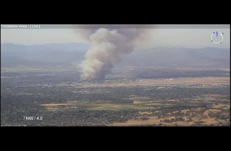
***Update: South Obenchain Fire*** Sept. 10, 2020, 11:45 a.m.
**Evacuation Map of Area: Red is Level 3, Yellow is Level 2, and the transparent shape is the fire**
Size: 20,250 acres
Start Date & Time: 1:52 PM 9/08/2020
Location: North of Eagle Point & extending east towards Butte Falls
Evacuation Level: Primarily Level 3 in the area
Weather: 95 degrees; low humidity; strong winds
Personnel: 340 approx.
Crews: 12
Engines: 15
Dozers: 17
Tenders: 21
Helicopters: 9
Air Tankers: 1
September 10, 2020
Springfield, Ore. – Firefighters celebrated some small successes yesterday on the Holiday Farm Fire. Fire behavior and weather conditions were still treacherous and kept firefighters from accessing many areas of the fire. In many cases, however, they were able to move fire around and away from structures. They utilized small “burnout” operations to remove lighter fuels in the path of the main fire. Burnouts enable a lower intensity burn that is more manageable and less destructive. These tactics aren’t always feasible due to factors such as wind, terrain, and fuel conditions. It is estimated that over 100 structures were saved yesterday.
The fire was mapped using an Infrared overflight last night at 144,695 acres. Containment remains at 0%. 207 personnel are assigned to the incident. Fire resources are spread thin across the western United States as large fires are burning in many states. Orders for critical needs have been placed.
Today, firefighters are expecting to see very unstable weather conditions across the fire area. Winds are expected to shift and begin blowing out of the west today and relative humidity is expected to remain between 10-15%. These weather conditions may contribute to another day of very active fire behavior.
Firefighters will be scouting areas for potential fire line location, providing structure protection, and continuing to assist with evacuations in areas under Level 3 evacuation orders. Many communities remain under Level 1, 2, or 3 evacuation orders. Current evacuation information can be found at:
Lane County: www.lanecounty.org/mckenziefire
Linn County: www.linnsheriff.org/fire_live_updates_sept_2020/
Residents are reminded that roads through the fire area are currently closed. These closures are for the safety of residents, as well as firefighting personnel. There are many hazards remaining, such as fire-weakened trees and falling rocks and other debris. Firefighters will begin conducting structural inventories and damage assessments when it is safe to do so.
Firefighters have support and supplies readily available to them from the fire camp. At this time, no donations can be accepted for the fire personnel. People looking to donate are encouraged to look at local organizations such as American Red Cross or United Way, who will be providing assistance to displaced residents. These individuals and their well-being is the highest priority for those wishing to make donations. This is also true for people wishing to volunteer with the fire suppression effort. All firefighting resources are ordered through systems that confirm the necessary qualifications.
Air quality is expected to be very unhealthy throughout the region today. Individuals are encouraged to avoid prolonged exposure to the outdoors or heavy exertion while outdoors.
| Estimated Size: |
144,695 |
| Containment: |
0% |
| Start Date/Time: |
9/7/2020, 8:20 p.m. |
| Expected Containment Date: |
10/29/2020 |
| Location: |
Lane County |
| Cause: |
Unknown |
| Personnel: |
207 |
| Assigned Resources:
Hand Crews:
Engines:
Dozers:
Water Tenders:
Other Heavy Equipment: |
3
24
3
4
0 |
| Assigned Aircraft:
Structure Task Forces: |
0
5 |
| Critical Resources Needs:
Injuries: |
Type 1 Crews, Type 2 Crews, Type 6 Engines, Aircraft, Overhead
0 |
| Structures Threatened: |
17,732 |
| Structures Damaged: |
Assessing |
| Structures Destroyed: |
Unknown |
| Evacuations: |
Level 1 (Ready), Level 2 (Set) and Level 3 (GO!) are in effect. |
September 9, 2020
***Update Sept. 9, 2020, 6:47 p.m.***
Fire Under Control. I-5 open.
***Update Sept. 9, 2020, 4:45 p.m.***
The Greenway MM 24 Fire is 2 miles Northeast of the Jackson County Expo.
Resources:
1 air tanker, 3 helicopters and ground support are on scene. More updates coming.
September 9, 2020
VENETA, Ore. — State forestland in Lane, Douglas, Coos, Jackson, Josephine, and Klamath counties are closed to public entry and use until further notice.
This includes the Gilchrist and Sun Pass state forests in Klamath County. Closure is necessary due to the current extreme fire conditions that are endangering life, forest resources, and property as well as very limited fire and emergency response resources.
This move means that all lands managed by the Oregon Department of Forestry are closed to public use. It also includes the Tillamook, Clatsop and Santiam state forests and other ODF-managed forestlands in Lane, Douglas, Coos, Jackson, Josephine, Klamath, Polk, Lincoln, & Benton counties. The Santiam State Forest is closed until further notice. Other closures in northwest Oregon will last until at least Sunday, Sept. 13 at 11 p.m.
September 9, 2020
September 9, 2020, 12:45 p.m.
South Obenchain Fire 9.09.2020
JACKSON COUNTY, ORE. – At 1:52 p.m. the Oregon Department of Forestry – Southwest Oregon District (ODF – SWO) detected smoke six (6) miles east of Eagle Point. Due to yesterday’s east wind event, in addition to Southwest Oregon’s ongoing high-heat and low humidity, the South Obenchain Fire quickly grew to 8000 acres. The strong wind gusts carried embers near Reese Creek, where a 1000-acre spot fire ignited. Structures are threatened, and a structural task force is on scene. The Jackson County’s Sheriff’s Office issued Level 2 and Level 3 evacuations.
Verify your evacuation level at https://jcgis.maps.arcgis.com/apps/webappviewer/index.html?id=3caa39804db54631a61007180d5ef415
At 6 a.m., ODF – SWO begun its day operations with approximately 120 firefighters, 7 helicopters, and 1 large air tanker; additional resources are expected. The team aims to draw a dozer line on the south face of the fire, and has established points of protections for a concentration of houses near highway 62.
September 9, 2020
Follow evacuations updates for Slater Fire.
Updated: Sept. 9, 2020, 11:30 a.m. – Mandatory Evacuation Orders have been extended from Clear Creek along Highway 96 to O’neil Creek Campground. The order extends from Highway 96 to the Oregon Border. The Evacuation Orders include the communities of Happy Camp and Seiad Valley.
PLEASE EVACUATE IMMEDIATELY!
News release from Slater Fire:
HAPPY CAMP, CALIFORNIA—The Slater Fire started during the night of September 7, near Slater Butte Fire Lookout on the Klamath National Forest. As of 8 am September 9, 2020 the wind driven wildfire has grown to an estimated 30,000 acres—moving in a northwesterly direction into Oregon. An estimated 150 homes were lost in the Happy Camp area. An evacuation order was issued for the town of Happy Camp as well as various roads adjacent to Happy Camp. Currently Highway 96 is closed from Fort Goff on the northeast side of Happy Camp and to Clear Creek on the southwest side. The Grayback Road is closed from Happy Camp northwest to Oregon. The community of Gasket, California has also been ordered to evacuate.
Initial attack fire fighters from the Klamath National Forest, CAL FIRE and local volunteers fire departments have been aggressively fighting the fire but high winds, high temperatures and very dry vegetation have hampered efforts. In addition, high winds and smoke have prevented use of air attack planes.
Incident Management Team 10 is arriving today. They will be taking over management of fire fighting efforts a 6 am, September 10, 2020.
A temporary evacuation center is available at the Seiad Volunteer Fire Department, 44601 Highway 96 in Seiad Valley, California 96086. An overnight evacuation center is available at the Karuk Tribal Wellness Center, 1403 Kahtisraam, Yreka, CA 96097.
Current evacuation orders are posted on Siskiyou County Sheriff Department Facebook at https://www.facebook.com/SiskiyouCountySheriff/.
Additional information on the Slater Fire is available on the Inciweb at https://inciweb.nwcg.gov/incident/7173/ and on Klamath National Forest Facebook https://www.facebook.com/KlamathNF/ and Klamath National Forest Twitter at https://twitter.com/Klamath_NF.
The new Fire Information phone number is 530-324-2528.
September 9, 2020
Lead agency: Oregon State Fire Marshal
September 9, 2020
September 8, 2020
Evacuations: Eagle Point & Shady Cove Area
South Obenchain Fire
JACKSON COUNTY, ORE. – At 1:52 p.m. Oregon Department of Forestry – Southwest Oregon District (ODF-SWO) detected smoke near South Obenchain Road. The fire quickly grew to 8000 acres due to dry weather conditions and strong winds. Jackson County Sheriff’s Office issued Level three (3) “GO” Evacuations for residents closest to the fire, and a Level two (2) Evacuation “Be Set” is in effect along Rogue River Drive from Highway 234 to Shady Cove; and along Highway 62, from Eagle Point to Shady Cove.
There is an evacuation point at the Jackson County Expo. It is not a shelter, it is a meeting point for friends and family to converge.
September 8, 2020
Governor’s news release from Sept. 8, 2020, 8:25 p.m.
(Salem, OR) — At 6:35 p.m., Governor Kate Brown approved an emergency conflagration declaration for the Alameda Fire in Jackson County, near the communities of Talent, Phoenix, and Medford. At the time of the declaration, homes and structures in the area were under level 3 mandatory evacuation orders.
“This situation is very dangerous,” said Governor Kate Brown. “Wind continues to fuel these wildfires, with devastating consequences across Oregon. People’s homes, lives and land are at risk. If you are in an evacuation area, please pay close attention and listen to local calls to evacuate as needed — this can save your life, your family and the lives of our firefighters.”
In accordance with ORS 476.510 – 476.610, Governor Brown determined that a threat to a life, safety, and property exists due to fire, and the threat exceeds the firefighting capabilities of local firefighting personnel and equipment. The Governor’s declaration authorizes the Oregon Office of State Fire Marshal to mobilize resources to assist local resources battling the fire.
September 8, 2020
September 8, 2020
ROGUE VALLEY, ORE. – Extreme fire weather and hazardous east winds has increased the fire danger on forestlands protected by Oregon Department of Forestry – Southwest Oregon District (ODF – SWO). To increase fire prevention measures and decrease the risk of new fire starts, a complete shutdown of industrial operations – such as logging sites and other commercial operations – is in the public’s best interest. Industrial Fire Precaution Level (IFPL) IV (4) is NOW in effect September 8, 2020.
All Operation are Prohibited. Complete Shutdown. Permits will not be granted.
ODF-SWO’s Public Fire Restrictions remain in effect and unchanged with a Fire Danger Level of “Extreme” (red). For more information about the Oregon Department of Forestry’s public or industrial fire season restrictions, visit our Facebook page: ODF Southwest Oregon District, or our website www.swofire.com.
September 8, 2020
Crews from the Douglas Forest Protective Association and Glide Rural Fire Department responded to a natural cover fire located approximately one mile northwest of Glide late Monday evening. The first engine to arrive on scene reported a 20 acre fire burning in light flashy fuels. Strong winds overnight fanned the flames which is now estimated to be 300 acres in size. Three bull dozers and numerous engines are currently engaged on the fire. A strike team of structural firefighters and equipment from various Douglas County fire departments are enroute to assist with structure protection. The cause of the French Creek Fire is currently under investigation.
The Douglas County Sheriff’s Office has issued a Level 3 or “GO!” Evacuation Notice for residents living on Single Tree Lane, Rivershore Drive and residents living along North Bank Road between the west side of Rivershore Drive and the Bridge. A Level 2 or “Be Set” Evacuation Notice remains in place for homes along French Creek Road. The Red Cross will have resources at the Glide Middle School parking lot for homeowners who have been evacuated.
Follow updates at DFPA. Or on Facebook: DFPA.
September 8, 2020
Two fires burning east of Glide displayed extreme fire growth Tuesday afternoon due to hot, dry and windy conditions. The Star Mountain Fire which originated in the Susan Creek area and the Archie Creek Fire which started in the Steamboat area are both estimated to be 6,000 to 8,000 acres in size with fire burning on both sides of Highway 138 East and the North Umpqua River. With strong east winds forecasted through Wednesday, these fires are expected to merge together and continue to spread to the west.
Multiple homes and recreational sites in and around the fire area have already received Level 2 “Be Set” and / or Level 3 “GO!” evacuation notices. Residents are urged to take these evacuation notices seriously and follow recommendations of responders. Evacuations notices are being coordinated between fire officials and the Douglas County Sheriff’s Office. Follow DCSO’s Facebook page for current evacuation notices. The Red Cross has a temporary resource center set up at the old Glide Middle School (301 Glide Loop Road) to assist residents displaced by the fire.
Highway 138 East remains closed to non-fire traffic between Milepost 17 and 47. Motorists are advised to use alternative routes and to monitor www.tripcheck.com for updates on the highway closure.
An Incident Management Team has been ordered by the Umpqua National Forest, the Roseburg BLM and the Douglas Forest Protective Association to lead suppression efforts on these two incidents. Wednesday morning, Northwest Interagency Incident Management Team 9 (I.C. Goff) will in-brief with local fire officials and assume command of the fire soon after.
The cause of both the Star Mountain Fire and the Archie Creek Fire remain under investigation.
Follow updates at DFPA. Or on Facebook: DFPA.
September 7, 2020
September 7, 2020
Grizzly Creek Fire Update 9.07.2020
ROGUE VALLEY, ORE. – At 6 a.m. September 5, 2020, the Oregon Department of Forestry – Southwest Oregon District (ODF – SWO) completed a dozer line around the fire. The line has been reinforced with hose lines to aid in containment efforts, which is currently at 20%. ODF – SWO has held the fire at its existing footprint, 340 acres.
| Fire Name |
Grizzly Creek Fire |
| Size |
340 |
| Containment % |
20% |
| Start Date & Time |
9/04/2020 2:25pm |
| Location |
1 Mile North of Howard Prairie Lake |
| Evacuation Level |
Level 2 (Bet Set) |
| Cause |
Under Investigation |
| Personnel |
Approx. 240 |
| Crews |
9 |
| Engines |
8 |
| Dozers |
6 |
| Tenders |
6 |
| Helicopters |
6 |
September 7, 2020
September 6, 2020

JACKSON COUNTY, ORE. – The residents closest to the Grizzly Creek Fire, near the Dead Indian Memorial Rd. and Keno Access Rd. junction, were evacuated on Friday per Evacuation Level Three (3) “GO” protocols. The Search and Rescue Division of the Jackson County Sheriff’s Office personally notified residents at their property of the level three (3) evacuation orders.
The Oregon Department of Forestry – Southwest Oregon District (ODF- SWO) and Jackson County Sheriff’s Office have jointly determined to downgrade from a level three (3) “GO” evacuation to a level two (2) “Be Set” evacuation for the ten (10) homes near the junction. This decision comes after ODF-SWO’s successful completion of a line. ODF-SWO is also expected to reach 15% containment before night operations begin.
Evacuation Level Two (2) is still in effect for resorts and campgrounds around the Howard Prairie Lake area.
September 5, 2020
September 4, 2020
Grizzly Creek Fire 9.04.2020
ROGUE VALLEY, ORE. – At approximately 2:25pm the Oregon Department of Forestry – Southwest Oregon District (ODF-SWO) detected smoke one (1) mile North of Howard Prairie Lake. ODF-SWO has responded with an aggressive initial attack: eight (8) helicopters, three (3) air tankers, six (6) engines, two (2) water tenders, two (2) dozers, and three (3) hand crews. The fire is expected to be 300-350 acres and ten (10) structures are threatened by the fire. The fire is 60% lined and is being reinforced with crews and hoses.
ODF-SWO has assembled 150 personnel for night operations: seven dozers (7), six (6) engines, five (5) hand crews, and four (4) water tenders. Night operations will establish a wet line and begin containment.
Evacuations: Level 2 (Be Set) evacuations have been placed in the Howard Prairie Lake region, including campgrounds/resorts. Campers have been notified and those traveling to the area have been informed to stay away and make new travel arrangements.
Road closures: Dead Indian Memorial Road is closed to eastbound traffic at the intersection of Hyatt Prairie Road near milepost 17. Dead Indian Memorial Road and Forest Service Road 37 is closed to all westbound traffic.
| Fire Name |
Grizzly Creek Fire |
| Size |
300-350 Acres |
| Start Date & Time |
2:25pm 9/04/2020 |
| Location |
1 Mile North of Howard Prairie Lake |
| Evacuation Level |
Level 2 in the Howard Prairie Lake area |
| Cause |
Under Investigation |
| Initial Attack Personnel |
Approx. 80 |
| Initial Attack Crews |
3 |
| Initial Attack Engines |
6 |
| Initial Attack Dozers |
2 |
| Initial Attack Tenders |
2 |
| Initial Attack Helicopters |
8 |
| Initial Attack Air Tankers |
2 |
| Structure Threatened |
10 |
| Night Operations Personnel |
Approx. 150 |
| Night Crews |
5 |
| Night Engines |
6 |
| Night Dozers |
7 |
| Night Tenders |
4 |
September 4, 2020
September 4, 2020
Meadows Fire
100% Lined, Mop-Up In-Progress
ROGUE VALLEY, ORE. – Local residents called in a “Human Caused” fire at 12:40 a.m. in Sams Valley: eight (8) miles Southwest of Shady Cove. The Oregon Department of Forestry – Southwest Oregon District (ODF-SWO) responded with five (5) engines, two (2) hand crews, one (1) dozer, and three (3) water tenders. There was approximately forty-five (45) ODF-SWO personnel on scene. Jackson County Fire District No. 3 also responded with one (1) engine and one (1) water tender. A preliminary investigation reveals that a down powerline is the cause of the four (4) acre fire.
Rogue Valley is in a fire weather “Red Flag Warning” today and into Labor Day weekend: triple digit heat, low humidity, and gusty winds. The risk of large costly fires is high. With 96% of Southwest Oregon’s fires being Human Caused this season, ODF asks that the public exercise extreme caution and follow local fire restrictions, Southwest Oregon is currently in “Extreme.”
| Fire Name |
Meadows |
| Size |
4 Acres |
| Containment % |
100% Contained, Mop-up in progress |
| Start Date & Time |
12:40 am, 9/4/2020 |
| Location |
Sams Valley (8 Miles Southwest of Shady Cove) / Block 14000 of Meadows Road |
| Expected Weather |
Triple Digit Heat, Low Humidity, Gusty Winds |
| Cause |
Human Caused (Under Investigation) |
| Personnel |
Approx. 45 |
| Crews |
2 |
| Engines |
5 |
| Dozers |
1 |
| Tenders |
3 |
| Structure Task Forces |
Fire District 3 was on scene with 1 engine and 1 water tender |
August 14, 2020
Under hot, dry conditions, all types of motorized vehicles can ignite a wildfire. An above average risk of large fires is expected in central Oregon, southwest Oregon, southeast Oregon, and central Washington through August. Fire officials ask for your help. Follow these basic safety tips when you ride or drive to keep an enjoyable outing from turning into a costly, damaging wildfire:
- Ensure all parts of your vehicle are secure and not touching the ground. A loose safety tow chain or muffler dragging on pavement can send a shower of sparks into dry vegetation, igniting not one but several wildfires along a roadside.
- Check your tire pressure and look for signs of wear. Once a flat tire shreds, the bare wheel on pavement can cast sparks onto roadside vegetation. This scenario has resulted in numerous Pacific Northwest wildfires. Likewise, poorly lubricated wheel bearings can overheat and ignite, and the metal-on-metal contact of a worn-out brake can emit sparks. Ensure that they receive regular maintenance.
- Maintain and clean exhaust systems and spark arrestors so they are undamaged and functioning properly. A worn-out catalytic converter can degrade and cast off extremely hot pieces of material, and a faulty spark arrestor can shed hot metal. Engine compartments can collect debris and ignite a spark. Also, regularly inspect the vehicle undercarriage to ensure that fuel and brake lines are intact and no oil leaks are apparent.
- A running vehicle’s exhaust system can reach temperatures up to 2,800 degrees Fahrenheit. Avoiddriving, idling, or parking on tall, dry grass or piles of brush that can touch the underside of a vehicle. A few seconds of contact between dry grass and a hot catalytic converter or exhaust system can start a fire. Operate ATVs on established roads and trails, and park on gravel surfaces or developed roadside pull-outs. Always carry an approved fire extinguisher on vehicles that are used off-road.
- Follow recreational forest laws during fire season, including whether off-road driving is permitted. Report all fires immediately. Keep a cell phone, water, a shovel and a fire extinguisher with you in the event a fire starts. Make sure that your RV’s cooking appliances, generator, and propane system are all working properly.
- Respect private forestlands and their designated closure areas.
Original Author:
Kristin Babbs, Executive Director
Keep Oregon Green Association
August 14, 2020
Danger levels rise for industrial and commercial operations on ODF Protected Lands
ROGUE VALLEY, ORE. – Increased fire danger on forestlands protected by the Oregon Department of Forestry’s Southwest Oregon District has made it necessary to increase the fire prevention measures on industrial operations, such as logging sites and other commercial operations. Industrial Fire Precaution Level (IFPL) III (3) takes effect at 12:01 a.m., Saturday, August 15th.
The following may operate during the hours of 8 p.m. and 1 p.m. daily:
-
- Power saws at loading sites
- Loading or hauling of any product or material
- Blasting
- Welding, cutting, or grinding of metal
- Any other spark emitting operation not specifically mentioned
Conditionally, the following may operate from 8:00 p.m. to 1:00 p.m. daily, when mechanized equipment capable of constructing fire line is immediately available to reach and effectively attack a fire start:
-
- Ground-based operations (tractor/skidder, feller-buncher, forwarder, or shovel logging operations)
- Power saws on ground-based operations
- Rotary head saw feller-bunchers with a continuous Firewatch
- Non-rotary head saw feller-bunchers
- Tethered logging – winch-assisted, cable-assisted, traction-assisted, etc. systems, which enable ground-based timber harvesting machines to operate on steep slopes
The following is prohibited at all times, except as indicated:
-
- Cable yarding systems (prohibited)
- Exception: gravity operated logging systems using non-motorized carriages, or approved motorized carriages, may operate between the hours of 8:00 p.m. and 1:00 p.m., if all blocks and moving lines are suspended at least 10 feet above the ground (excluding: the line(s) between the carriage and the chokers during rigging).
For the general public, ODF Southwest’s fire restrictions remain in effect and unchanged with a fire danger level of “extreme” (red). For more information about the Oregon Department of Forestry’s public or industrial fire season restrictions, visit our Facebook page: ODF Southwest Oregon District, or our website www.swofire.com.