September 2, 2016
The 61-acre Gold Canyon Fire is now 85 percent contained.
The forecast is favorable for firefighting efforts throughout the day; temperatures range from 75 to 80 degrees and relative humidity will remain in the upper 20s. Wind gusts up to 5 mph could be present by the afternoon.
Firefighters will be mopping up 500 to 600 feet inside the fire line today further strengthening the containment of this fire. As long as conditions do not change, resources will begin being pulled from the fire Saturday.
Residents on Wildpark Lane and Reeves Creek Road will remain at a Level 1 (Ready) Evacuation Level throughout the day as a precaution. No structures have been lost.
The fire was reported Tuesday at 4:53 p.m. and its cause is under investigation. The fire investigator has made progress toward narrowing down the cause; however, official results have not been released.
Fire management officials ask that the public continue to use caution and adhere to regulations. Current fire restrictions for lands in Jackson and Josephine Counties protected by the Oregon Department of Forestry Southwest Oregon District can be found at
www.swofire.com.
September 1, 2016
|
In the past 24 hours, air and ground support on the Gold Canyon Fire made significant progress on containment. The 61-acre fire is now 60 percent contained.
Fire activity is expected to remain minimal today. Temperatures will be cooler today in the high 70s and low 80s; however, there is a potential for wind gusts throughout the afternoon.
Firefighters will be mopping up 200 feet inside the fire line today further strengthening the containment of this fire. Ground crews will also be gridding green areas surrounding the line for potential hot spots.
Residents on Wildpark Lane and Reeves Creek Road will remain at a Level 1 (Ready) Evacuation Level throughout the day as a precaution. No structures have been lost.
The fire was reported Tuesday at 4:53 p.m. and its cause is under investigation. The Oregon Department of Forestry’s Southwest Oregon District is still asking the public’s help in identifying the person or people who may be responsible for starting the Gold Canyon Fire.
Please call the Oregon Department of Forestry’s Grants Pass Unit office at (541) 471-3883 if you have information that will help identify people or vehicles in the area at that time. Information received will be confidential.
Fire management officials ask that the public continue to use caution and adhere to regulations. Current fire restrictions for lands in Jackson and Josephine Counties protected by the Oregon Department of Forestry Southwest Oregon District can be found at www.swofire.com.

|
| ODF Southwest Oregon District Medford Crew 319 on the first day of the fire shortly after a retardant drop. |
August 31, 2016
Today firefighters walked the divisions of the Gold Canyon Fire allowing for a more accurate mapping of the perimeter. Crews used handheld GPS units to walk along the fire, now estimating it at 61 acres. The fire is 30 percent contained.
Residents on Wildpark Lane and Reeves Creek Road will remain at a Level 1 (Ready) Evacuation Level throughout the night. No structures have been lost.

Firefighters on the ground are facing steep terrain. While tomorrow’s temperatures are favorable throughout the morning, low relative humidity and variable wind gusts up to 20 mph could pose a challenge for firefighters on the line by the afternoon. Tonight firefighters will continue to extinguish hot spots and make sure fire lines remain secure.
The fire was reported Tuesday at 4:53 p.m. and its cause is under investigation. The Oregon Department of Forestry’s Southwest Oregon District is asking the public’s help in identifying the person or people who may be responsible for starting the Gold Canyon Fire.
Please call the Oregon Department of Forestry’s Grants Pass Unit office at (541) 471-3883 if you have information that will help identify people or vehicles in the area at that time. Information received will be confidential.
Fire management officials ask that the public continue to use caution and adhere to regulations. Current fire restrictions for lands in Jackson and Josephine Counties protected by the Oregon Department of Forestry Southwest Oregon District can be found at
www.swofire.com.
August 31, 2016
The Oregon Department of Forestry’s Southwest Oregon District is asking the public’s help in identifying the person or people who may be responsible for starting yesterday’s Gold Canyon Fire, which burned 120 acres of forestland south of Selma in Josephine County. The fire was reported at 4:53 p.m. Tuesday alongside Highway 199 (Redwood Highway) near the intersection with Gold Canyon Drive.
Please call the Oregon Department of Forestry’s Grants Pass Unit office at (541) 471-3883 if you have information that will help identify people or vehicles in the area at that time. Information received will be confidential.
August 31, 2016
Fire crews worked through the night building and strengthening fire line on the Gold Canyon Fire south of Selma. The fire is approximately 120 acres, 100 percent lined and 20 percent contained as of this morning.
The fire was reported Tuesday at 4:53 p.m. burning in steep terrain consisting of tall brush and timber. The cause is under investigation.
Weather conditions today call for temperatures in the mid 80s. While temperatures and relative humidity is favorable, there is a chance of variable winds reaching 5 mph.
This morning firefighters will continue to strengthen fire line, monitor fire activity for hot spots and mop up 50 feet within the line. Fire crews will also be walking the perimeter in order to get an accurate size of acres burned. Unless conditions change, we anticipate the fire size to be smaller than originally estimated from the air.
Today, residents on Wildpark Lane and Terrece Place will remain at a Level 2 (Set) Evacuation Level; residents on Reeves Creek Road will remain at a Level 1 (Ready) Evacuation Level, unless conditions change. The Rogue Valley Strike Team has been released, and the Illinois Valley Fire District will lead structural protection throughout the day.
An American Red Cross shelter has been set up at Rogue Community College in Grants Pass in the gymnasium for residents evacuated from the Gold Canyon Fire.
Redwood Highway is back open this morning. Please be cautious while driving through the fire area. There will be an increased presence of fire traffic along the road.
Fire management officials ask that the public continue to use caution and adhere to regulations. Current fire restrictions for lands in Jackson and Josephine Counties protected by the Oregon Department of Forestry Southwest Oregon District can be found at www.swofire.com.
August 30, 2016
Tonight firefighters will work to complete a fire line around the perimeter of the roughly 120-acre Gold Canyon Fire.
The fire burning south of Selma on ODF-protected lands is 85 percent lined and five percent contained.
Approximately 200 structures are threatened by the fire. However, no structures have been lost.
Residents on Wildpark Lane and Terrece Place are being reduced to a Level 2 (Set) Evacuation Level; residents on Reeves Creek Road are being reduced to a Level 1 (Ready) Evacuation Level, effective immediately.
An American Red Cross shelter has been set up at Rogue Community College in Grants Pass in the gymnasium for residents evacuated from the Gold Canyon Fire.
 |
| Gold Canyon Fire, photo courtesy of ODF ATGS Jesse Blair |
Air attack was an integral part of today’s firefight. Heavy air tankers and helicopters made numerous drops on the fire.
Firefighters on the ground are facing steep terrain. While tomorrow’s temperatures are favorable, there is still the chance of evening variable winds.
A structural protection strike team was activated to protect homes and other structures in the event the wildfire moved closer to homes. The team is assembled from engines and personnel from fire districts in Jackson and Josephine counties consisting of units from Jackson County Fire District #5 IAFF Local 2596, Jackson County Fire District 3, Medford Fire-Rescue, Jacksonville Fire, Ashland Fire-Rescue, Applegate Valley Fire, City of Grants Pass Fire, Illinois Valley Fire District, Rural Metro Fire Josephine County and Rogue River Fire. Some engines will remain in place throughout tonight.
 |
| Gold Canyon Fire, photo courtesy of IVFD Dale Sandberg |
By the morning, inmate crews and additional private contractors will be assisting with the fire.
The fire was reported today at 4:53 p.m. and its cause is under investigation.
Fire management officials ask that the public continue to use caution and adhere to regulations. Current fire restrictions for lands in Jackson and Josephine Counties protected by the Oregon Department of Forestry Southwest Oregon District can be found at www.swofire.com.
August 27, 2016
This is the final update about the Cleveland Ridge Fire unless conditions change.
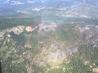
The number of hot spots remaining inside the Cleveland Ridge Fire’s fire line is dwindling as burning vegetation either naturally burns out, or firefighters extinguish them. The day shift’s objective is to put out all hot spots within 300 feet of the fire line, and go farther when it is warranted.
The fire remains at 530 acres and is 80 percent contained. Today, 130 firefighters are working on the fire. Last night, 85 firefighters continued the mop-up operation and patrolled the fire perimeter.
The number of private contract firefighters assigned to the Cleveland Ridge Fire will continue to decrease this weekend until the final mop-up operation is turned over to seven 10-man crews from the Oregon Department of Corrections. They will be supported by a small fleet of wildland fire engines and water tenders, as well as fallers to cut down hazardous trees. An air tanker, helicopters and bulldozers will be available from the Oregon Department of Forestry’s Southwest Oregon District, based in Central Point.
The fire burned on private and Bureau of Land Management forestland 5 miles north/northwest of Shady Cove. Rehabilitation projects to protect the landscape against undue erosion and invasive plants will begin as mop-up operations decrease.
August 25, 2016
The fire line around the 530-acre Cleveland Ridge Fire held today and firefighters turned to the task of mopping up remaining hot spots. The night shift crews will work toward completely extinguishing anything still burning within 100 feet of the fire line.
The fire is 50 percent contained.
More than 200 firefighters are working on the fire tonight. They have been counseled to watch for falling trees and rolling rocks, along with less-obvious hazards such as rattlesnakes, yellowjacket wasp nests and poison oak.
The fire began Monday afternoon below Cleveland Ridge, located on private and Bureau of Land Management forestland 5 miles north/northwest of Shady Cove.
TouVelle State Park in Central Point is closed to the public as the park is being used as the fire camp. Please avoid the area in order to allow fire traffic the accessibility they need to the entrance/exit points.
August 25, 2016
Firefighters were finally able to safely walk the perimeter of the Cleveland Ridge Fire last night allowing for a more accurate mapping of the fire. Until firefighters deem the perimeter safe, sizing estimates are made by aerial support. Crews used handheld GPS units to walk along the fire, now estimating it at 530 acres. Fire crews also strengthened fire line overnight, with some areas reaching 25 to 30 feet wide in order to prevent spot fires today.
The fire burning on private and Bureau of Land Management forestlands north/northwest of Shady Cove has a fire line completed around 100 percent of the fire and is 35 percent contained as of this morning.
The fire was reported at 4:01 p.m. Monday and started near the West Fork of Trail Creek Rd. The cause of the fire is under investigation.
Air and ground support will work today to knock down the fire, continue strengthening control lines and work on mopping up hot spots along the perimeter. There will be a focus on the north side of the fire where the Cleveland Ridge Fire is most actively burning.
Weather conditions today could pose a challenge for firefighters. Temperatures are expected to range from 95-98 degrees, relative humidity between 10-12 percent, morning east/northeast winds at 3 mph with potential gusts up to 8 mph, and evening north/northwest winds at 3-5 mph with gusts up 8 mph. The fire is burning in grass, brush and mixed-age conifer forest. The topography ranges from moderate to very steep. Road access is good to the east and west flanks of the fire, and has increasingly improved on the north side.
The Level 1 (Be Ready) Evacuation Notice will remain in effect for residents on Taylor Rd. and the West Fork of Trail Creek Rd., as well as residents along Hwy. 227 from the junction with the West Fork of Trail Creek Rd. to address 6481 Hwy. 227. Firefighters will continue to monitor all structures surrounding the flanks of the fire throughout the day.
Sections of West Fork Trail Creek Road remain closed today. While all other roads are currently open, we ask that people are cautious while traveling through areas with high fire traffic.
As a reminder, TouVelle State Park in Central Point is closed to the public. The park is being used as the site for the Cleveland Ridge Fire fire camp. Please avoid the area in order to allow fire traffic the accessibility they need to the entrance/exit points.
Fire management officials ask that the public continue to use caution and adhere to regulations. Current fire restrictions for lands in Jackson and Josephine Counties protected by the Oregon Department of Forestry Southwest Oregon District can be found on the district’s Facebook page
ODF Southwest Oregon District and the website
www.swofire.com.
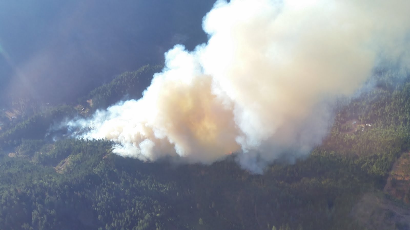
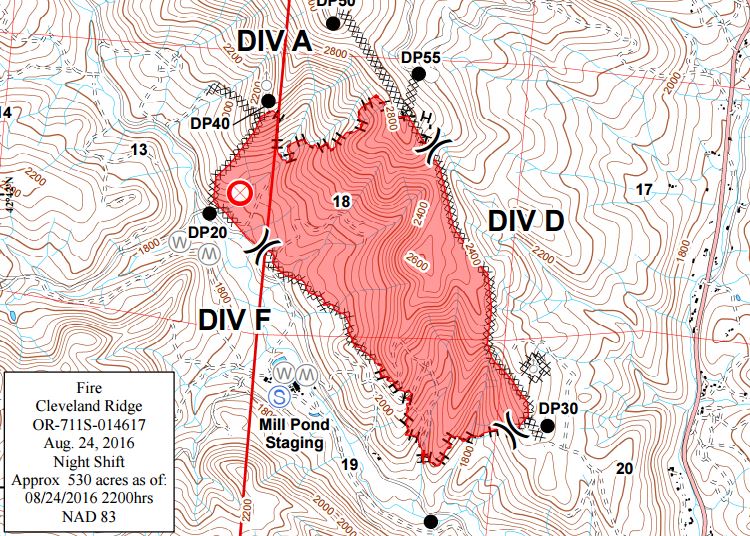
August 24, 2016
Firefighters are holding the Cleveland Ridge Fire at 635 acres. The fire burning on private and Bureau of Land Management forestlands north/northwest of Shady Cove has a fire line completed around 100 percent of the fire and is 25 percent contained as of tonight.
With the help of aerial support, day shift firefighters made significant progress on the north end of the fire. While the fire is still burning toward the north, night shift crews will continue to strengthen the fire line in order to prepare for the warm temperatures and high winds expected by tomorrow evening.
The Level 2 (Be Set) Evacuation Notice in place is being reduced to a Level 1 (Be Ready) Evacuation Notice for residents on Taylor Rd. and the West Fork of Trail Creek Rd., as well as residents along Hwy. 227 from the junction with the West Fork of Trail Creek Rd. to address 6481 Hwy. 227. We would like to thank all of the fire agencies in Jackson and Josephine Counties for their assistance with structural protection. Road blocks and closures on West Fork of Trail Creek Road are still in place as firefighters continue to work on the Cleveland Ridge Fire.
As a reminder, TouVelle State Park in Central Point is closed to the public. The park is being used as the site for the Cleveland Ridge Fire fire camp. Please avoid the area due to increased fire traffic, if possible.
The fire was reported at 4:01 p.m. Monday, and its cause is under investigation.
Fire management officials ask that the public continue to use caution and adhere to regulations. Current fire restrictions for lands in Jackson and Josephine Counties protected by the Oregon Department of Forestry Southwest Oregon District can be found on the district’s Facebook page at
ODF Southwest Oregon District, and www.swofire.com.August 23, 2016
A force of more than 200 firefighters worked throughout the day to relocate fire lines on the northeast and southeast flanks of the Cleveland Ridge Fire, burning on private and Bureau of Land Management forestlands north/northwest of Shady Cove. The fire grew along these flanks today but a wide bulldozer-constructed fire line along the spine of Cleveland Ridge held as the fire reached the ridgetop.
The fire has reached 574 acres in size and fire line has been completed around 80 percent of the fire.
The night shift crews, comprised of approximately 150 firefighters, will work to complete the fire line on the north flank and hold established fire lines around the rest of the perimeter.
Residents on Taylor Rd. and the West Fork of Trail Creek Rd. remain under a Level 2 (Set) Evacuation Level, which into effect at 8:00 a.m. today. Residents along Hwy. 227 from the junction with the West Fork of Trail Creek Rd. to address 6481 were also placed under the Level 2 alert. More than 40 structures are within the evacuation alert area.
A structural protection strike team stood by today to protect homes and other structures in the event the wildfire posed a threat. The team is assembled from engines and personnel from fire districts in Jackson and Josephine counties. They will remain in place throughout tonight.
Helicopters with water buckets flew throughout the day to cool spot fires and hot spots along the fire lines. (One of the helicopters made 105 bucket drops.) Air tankers made numerous retardant drops in areas where the fire either crossed or threaten to cross fire lines.
Much of the increased acreage today was due to the fire burning a large tract of forestland west of Cleveland Ridge. This area contains many steep, rocky bluffs and other rugged terrain that was too dangerous for firefighters to work in.
The fire was reported at 4:01 p.m. Monday, and its cause is under investigation.
August 23, 2016
A Level Two, “Be Set,” evacuation notice is in effect for homes along Tiller Trail Highway 227 from W. Fork Trail Creek Rd. through 6481 Tiller Trail Highway 227, as well as areas surrounding the fire along W. Fork Trail Creek Rd. No structures have been lost, but at least 40 are threatened.
August 23, 2016
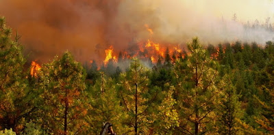
Fire crews worked through the night building fire line on the Cleveland Ridge Fire, located approximately 5 miles north/northwest of Shady Cove. The fire is approximately 250 acres and 70 percent lined as of this morning.
The fire was reported at 4:01 p.m. Monday and burned nearly 200 acres of forest by nightfall. The cause of the fire is under investigation.
Weather conditions today call for temperatures 90-95 degrees, relative humidity between 15-20 percent, and northwest wind at 5 mph. The fire is burning in grass, brush and mixed-age conifer forest. The topography ranges from moderate to very steep. Road access is good to the east and west flanks of the fire, and poor on the north side.
This morning firefighters will continue to evaluate the need for evacuation notices. The potential for a Level One, “Be Ready,” evacuation notice for homes along Tiller Trail Highway 227 as well as remote areas surrounding the fire is possible within the upcoming hours. No structures have been lost, but at least 40 are threatened.
Sections of West Fork Trail Creek Road remain closed today. While all other roads are currently open, we ask that people are cautious while traveling through areas with high fire traffic.
 |
| A view from ODF air attack on the Cleveland Ridge Fire on August 22, 2016. |
Along with Oregon Department of Forestry crews from the Southwest Oregon District’s Medford and Grants Pass units, a Rogue Valley Strike Team has been activated. The strike team consists of structural protection units from Jackson County Fire District 4, Jackson County Fire District 5, Jackson County Fire District 3, Medford Fire-Rescue, Jacksonville Fire and Ashland Fire-Rescue. Ten-man and 20-man crews are also on scene, and several Oregon Department of Corrections inmate crews have arrived to assist with fire line construction and mop-up.
Firefighters will work today to knock down the fire, strengthen control lines and work on mopping up hot spots along the perimeter.
The fire is burning on Bureau of Land Management and private lands, all of which are protected by the Oregon Department of Forestry’s Southwest Oregon District.
Fire management officials ask that the public continue to use caution and adhere to regulations. Current fire restrictions for lands in Jackson and Josephine Counties protected by the Oregon Department of Forestry Southwest Oregon District can be found on the district’s Facebook page at “
ODF Southwest Oregon District” and the website www.swofire.com.
August 22, 2016
Tonight several firefighters will continue working on the roughly 200-acre Cleveland Ridge Fire.
The fire that started near Trail is 30 percent lined.
The fire is burning on grass, brush, and timber on Bureau of Land Management and private land owner property all protected by the Oregon Department of Forestry Southwest Oregon District.
Approximately 40 structures are threatened by the fire. However, there are no evacuations in place moving forward tonight. We will reevaluate fire activity and the need for evacuation notices in the morning. No structures have been lost.
Along with ODF crews from Medford and Grants Pass, the Rogue Valley Strike Team was activated. The strike team consists of structural protection units from Jackson County Fire District 4, Jackson County Fire District 5, Jackson County Fire District 3, Medford Fire-Rescue, Ashland Fire, and Jacksonville Fire. Ten-man and Twenty-man crews are also on scene.
Firefighters on the ground are facing steep terrain. While tomorrow’s temperatures are more favorable, there is still the chance of evening variable winds.
Air attack was an integral part of today’s firefight. Four Type 2, one Type 3, one heavy air tanker, and two SEATs created a retardant line along the right flank and upper portion of the left flank of the fire.
By the morning, inmate crews and additional private contractors will be assisting with the fire.
Since the priority tonight was fire suppression, the fire investigation will continue tomorrow.
August 22, 2016
Air attack just finished making their final rounds on the #ClevelandRidgeFire near Trail.
The fire started just after 4 p.m. Near W. Fork Trail Creek Road.
The fire has burned 180 acres of grass, brush, and timber and continues to grow. However, the rate of spread has significantly slowed since sundown.
The only area under a Level One, “Be Ready”, evacuation notice is Taylor Road which runs parallel to Tiller Trail Highway 227. Some residents have already decided to self-evacuate the area.
The cause of the fire is under investigation.
We will have a final evening update shortly.
August 16, 2016
The fire danger level rises to “Extreme” (red) at 12:01 a.m. Thursday, August 18, in the Wild & Scenic Section of the Rogue River. The Oregon Dept. of Forestry protects the Bureau of Land Management section of the river between Grave Creek and Marial, and the Rogue River-Siskiyou National Forest protects the section from Marial downstream to Watson Creek.
Here are the regulations going into effect on Thursday:
- Smoking will be prohibited except in boats on the water, and on naturally vegetation-free gravel bars and sand bars below the river’s high-water mark.
- Open fires will be prohibited, including camp fires, charcoal fires, cooking fires and warming fires. However, portable cooking stoves using liquefied or bottled fuels will be allowed on naturally vegetation-free gravel bars and sand bars below the high-water mark
- Travelers must carry a shovel and bucket (one-gallon size).
- Fireworks will be prohibited.
For further information about fire restrictions in all parts of the Wild and Scenic Section of the Rogue River, contact the Smullin Visitor Center located at the Rand National Historic Site at (541) 479-3735.
For more information and to see the full text of the Rogue River-Siskiyou National Forest order, including a list of designated recreation sites where campfires are permitted, visit http://www.fs.usda.gov/alerts/rogue-siskiyou/alerts-notices.
For more information about the Oregon Department of Forestry’s fire season regulations, contact ODF’s Grants Pass Unit at 5375 Monument Drive, Grants Pass. The phone number is (541) 474-3152.
August 16, 2016
Industrial operations on Oregon Department of Forestry-protected lands in Jackson and Josephine counties will be required to follow stricter fire prevention regulations starting at 12:01 a.m. on Thursday, August 18. Industrial Fire Precaution Level 3 (three) requires logging, road building and other operations in forests and wildland areas to shut down most equipment by 1:00 p.m.
These measures are necessary to prevent wildfires as much of the southwest portion of the state is in a period of hot weather, dry afternoon winds and low humidity.
The public regulated use fire danger level climbed to “Extreme” (red) on Monday and will remain at that level for the foreseeable future.
Under Industrial Fire Precaution Level 3, the following fire prevention regulations take effect on Thursday:
- Cable yarding will not be allowed. However, gravity operated-logging systems employing non-motorized carriages may operate until 1:00 p.m. and after 8:00 p.m. These systems must have all blocks and moving lines suspended 10 feet above the ground, except the line between the carriage and the chokers;
- Power saw use will not be allowed. However, power saws may be used until 1:00 p.m. and after 8:00 p.m. at loading sites and on tractor or skidder operations;
- In addition, the following equipment and operations must shut down between 1:00 p.m. and 8:00 p.m.:
- Tractor/skidder, feller-buncher, forwarder, or shovel logging operations where tractors, skidders or other equipment with a blade capable of constructing fireline are immediately available to quickly reach and effectively attack a fire start;
- Mechanized loading or hauling of any product or material;
- Blasting;
- Welding or cutting of metal;
- Any spark-emitting activity not specifically mentioned above.
The following IFPL regulations are currently in effect and will remain in effect:
- The use of fire in any form is prohibited;
- Commercial operations must have fire suppression equipment on the job site;
- Watchman service must be provided.
For more information about the Oregon Department of Forestry’s fire season regulations, contact the unit office in your area:
- Medford Unit, 5286 Table Rock Rd., Central Point. Phone: (541) 664-3328
- Grants Pass Unit, 5375 Monument Drive, Grants Pass. Phone: (541) 474-3152
August 16, 2016
The Redwood Highway Fire is 100 percent contained.
The fire burned 54 acres since it started on August 12 in Selma along Redwood Highway. Firefighters still on scene will be returning home today.
The fire destroyed three homes, several outbuildings and prompted the evacuation of dozens, all whom have been allowed to return home, with the last evacuation notice lifted Saturday night.
As of Sunday morning, there were no longer any road closures in effect due to fire activity and all temporary flight restrictions in the area have been lifted.
The fire was fueled by hot temperatures, gusty winds and dry vegetation. These factors made for a quick-moving fire that was able to jump the highway in a matter of minutes.
The Oregon Department of Forestry Southwest Oregon District would like to thank all agencies in Josephine and Jackson Counties that assisted with the containment of this fire.
August 14, 2016
Very dry conditions in southwest Oregon’s forests and wildlands makes it necessary for the Oregon Department of Forestry’s Southwest Oregon District to shut down public use of power-driven and spark-emitting internal combustion engines starting Monday, Aug. 15, at 8:00 a.m.
The pubic regulated use fire danger level will be “extreme” (red) but the Industrial Fire Precaution Level will remain at 2 (two).
These regulations affect the 1.8 million acres of state, private, county and Bureau of Land Management forestlands in Jackson and Josephine counties.
Below are the public regulated use restrictions that take effect Monday:
- Chain saw use will be prohibited;
- Mowing of dried and cured grass with power driven equipment will be prohibited, except for the mowing of green lawns, or the commercial culture and harvest of agricultural crops;
- Cutting, grinding and welding of metal will be prohibited;
- The use of any other spark-emitting internal combustion engine will be prohibited.
The following public regulated use restrictions are currently in effect and will remain in effect:
- Debris burning is prohibited;
- Burn barrel use is prohibited;
- Smoking is prohibited while traveling, except in vehicles on improved roads;
- Open fires are prohibited, including campfires, charcoal fires, cooking fires and warming fires, except at designated locations. Portable cooking stoves using liquefied or bottled fuels are allowed;
- Use of motor vehicles, including motorcycles and all-terrain vehicles is prohibited, except on improved roads;
- Use of fireworks is prohibited;
- Any electric fence controller in use shall be: 1) Listed be a nationally recognized testing laboratory or be certified by the Department of Consumer and Business Services, and 2) Operated in compliance with manufacturer’s instructions;
- Use of exploding targets is prohibited;
- Use of tracer ammunition or any bullet with a pyrotechnic charge in its base is prohibited;
- Use of sky lanterns is prohibited.
For more information about the Oregon Department of Forestry’s public regulated use regulations, please call or visit the Southwest Oregon District unit office nearest to you:
- Medford Unit, 5286 Table Rock Rd., Central Point. (541) 664-3328
- Grants Pass Unit, 5375 Monument Dr., Grants Pass. (541) 474-3152
August 13, 2016
The Redwood Highway Fire remains at 50 acres this evening and is 90 percent contained. Roadblocks on Deer Creek Road will be removed at 7:00 p.m. and the evacuation level for all areas around the burned area will drop to Level 1 (Ready) at the same time.
The fire started Friday afternoon in the community of Selma, located nine miles north of Cave Junction in southern Josephine County. The fire crossed Highway 199 near Ray’s Market in Selma and continued burning east of the highway. Three homes and several outbuildings were destroyed.
Today, fire crews extinguished hot spots all around the fire’s perimeter and a helicopter patrolled overhead watching for spot fires. Tonight, a 20-person supported by an engine and a water tender will continue mopping up and patrolling.
Wildland fire suppression crews from the Oregon Department of Forestry were aided today by engines and personnel from the Illinois Valley Fire District, Rural Metro Fire Department, Grants Pass Fire-Rescue and several private contractors.
The Oregon Department of Forestry and Oregon State Police continue their investigation into the cause of the Redwood Highway Fire.