September 24, 2015
Fire-weary Oregonians are like soldiers lately returned from the battlefield who duck at the sound of a car backfiring – a glimpse of smoke in the distance raises anxiety. But fall is when the counterpoint to wildfire emerges on the landscape: prescribed forest burning.
Many forest landowners are currently planning controlled burns to occur whenever wildfire danger subsides in their areas. These deliberate fires meet a twofold purpose:
- Prepare logged sites for replanting of young trees
- Reduce fuel loads to lower the risk of wildfires next summer
Unlike wildfires, which occur under the worst of conditions, prescribed burns are conducted only when weather and wind patterns are optimal to carry smoke up and away from communities and popular recreation sites. And forest operators and wildland fire agencies staff the sites with fire engines and personnel to prevent the burns from spreading outside of designated burn units.
The Oregon Department of Forestry’s (ODF) meteorologists nail the forecast much of the time. But wind shifts occasionally push some smoke from prescribed burns into populated areas. However, most agree the tradeoff is well worth it. Some 200,000 acres of forestland undergo prescribed burn treatments annually in the state, and the resulting clean-up of logging debris and excess vegetation greatly reduces the risk of damaging wildfires on those lands during the summer.
The man who heads up ODF’s firefighting program believes that significantly expanding Oregon’s prescribed burning program would improve the wildfire situation.
“I’d like to see the 200,000 acres of annual prescribed burning double,” said Doug Grafe, chief of ODF’s Forest Protection Division. Three severe wildfire seasons in a row, 2013-15, have reinforced his fervor for forest fuel treatments via prescribed fire.
When a wildfire moves into a tree stand that has been previously thinned and excess shrubs and grasses removed, he said, the flames tend to stay on the forest floor. Wildland firefighters are able to attack a ground fire directly. But when a wildfire ignites in a stand where the trees are close together and brush is thick, it will likely move into the crowns and race through the stand. Direct attack is dangerous in this scenario, so fire managers must resort to air tankers and helicopters – effective, but costly tools.
The high intensity of a wildfire burning in a fuel-rich forest often does long-term damage, wiping out entire tree stands and in some instances sterilizing the soil. In contrast, a wildfire in a fire-treated forest typically leaves many of the trees alive.
Prescribed burning is already underway in some parts of Oregon, where the fall weather pattern of cooler temperatures and higher humidity has lowered the risk of a burn escaping control. But in many areas, ODF is holding off on issuing burning permits till the seasonal rains set in. For example, forest landowners in ODF’s Northeast Oregon District have some 10,000 acres of burn piles ready to light whenever they get the go-ahead from the department, likely in early November. The Klamath-Lake District says it will also wait till then before issuing burn permits.
More information about prescribed forest burning and smoke management can be found on the Department of Forestry website.
September 18, 2015
The fire danger level decreased to “high” (yellow) this week in the Wild and Scenic section of the Rogue River between Grave Creek and the mouth of Watson Creek. The Wild and Scenic section of the river between Grave Creek and Marial is managed by the Bureau of Land Management and protected from fire by the Oregon Department of Forestry’s Southwest Oregon District. The section of the river from Marial downstream to Watson Creek is managed and protected from fire by the Rogue River-Siskiyou National Forest.
The following fire prevention restrictions are currently in effect:
- Smoking is prohibited while traveling, except in boats on the water, and on sand or gravel bars that lie between water and high water marks that are free of vegetation.
- All travelers are required to carry one shovel and a one-gallon or larger bucket.
- The use of fireworks is prohibited.
- Campfires, including cooking fires and warming fires, are prohibited. However, charcoal fires for cooking and built in raised fire pans are allowed on sand or gravel bars that lie between water and high water marks that are free of vegetation. Ashes must be hauled out. Portable cooking stoves using liquefied or bottled fuels may also be used.
For further information about fire restrictions in the Wild and Scenic Section of the Rogue River, contact:
- The Oregon Department of Forestry, Grants Pass Unit, (541) 474-3152;
- The Smullin Visitor Center located at the Rand National Historic Site at (541) 479-3735.
- The Rogue River-Siskiyou National Forest
September 16, 2015
The fire danger level on Oregon Department of Forestry-protected lands in Jackson and Josephine counties has been lowered to “high” (yellow) today. The Industrial Fire Precaution Level has also been decreased to level 2 (two).
These regulations affect 1.8 million acres of state, private, county, city and Bureau of Land Management lands protected by ODF’s Southwest Oregon District.
Light rain and cooler temperatures across southwest Oregon have made it possible to ease off on some of the fire prevention regulations. However, very warm and dry weather is expected to return to the region by the weekend.
Restrictions on the public use of chain saws, brush cutters and other power-driven machinery have been relaxed a bit, allowing the use of equipment until 1:00 p.m. Before today, power-driven machinery had to be shut down by 10:00 a.m. Power-driven machinery use may resume after 8:00 p.m.
Other fire prevention regulations currently in effect, and which will remain in effect, include:
- No debris burning, including piles and debris burned in burn barrels;
- No fireworks use on forestlands;
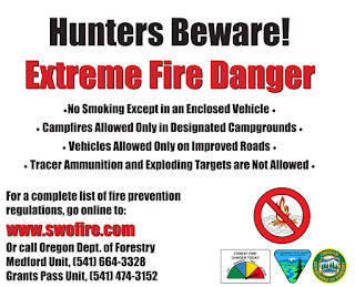
- Exploding targets and tracer ammunition, or any bullet with a pyrotechnic charge in its base, are prohibited;
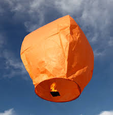
- No sky lanterns may be used in wildland and forestland areas.
- Campfires are allowed only in designated campgrounds. Portable stoves using liquefied or bottled fuels may be used in other locations;
- Motorized vehicles are allowed only on improved roads;
- Chain saws may be used until 1:00 p.m. and after 8:00 p.m. Chain saw users must have an ax, a shovel and an 8-oz or larger fire extinguisher at the job site, and a fire watch is required for one hour after the saw is shut down;
- Mowing of dead or dry grass with power-driven equipment is allowed until 1:00 p.m., and may resume after 8:00 p.m. This restriction does not apply to mowing green lawns, or to equipment used for the commercial culture and harvest of agricultural crops;
- The cutting, grinding or welding of metal are allowed until 1:00 p.m. and after 8:00 p.m. These activities may only take place at a site cleared of potentially flammable vegetation and other materials, and with a water supply at the job site;
- Smoking while traveling is allowed only in enclosed vehicles on improved roads;
- Electric fence controllers must be approved by a nationally recognized testing laboratory, such as Underwriters Laboratories Inc., or be certified by the Department of Consumer and Business Services, and be installed and used in compliance with the fence controller’s instructions for fire safe operation.
In the Wild and Scenic Section of the Rogue River between Grave Creek and Marial, charcoal fires may now be used for cooking provided a raised pan is used and conducted only in an area free of vegetation and other flammable material. Ashes must be hauled out.
Under Industrial Fire Precaution Level II:
- The use of fire in any form is prohibited
- The use of power saws is prohibited, except at loading sites, between 1:00 p.m. and 8:00 p.m.
- The use of cable yarders is prohibited between 1:00 p.m. and 8:00 p.m.
- Blasting is prohibited between 1:00 p.m. and 8:00 p.m.
- Welding or cutting of metal are prohibited between 1:00 p.m. and 8:00 p.m.
Additionally, commercial operators on forestlands are required to have fire suppression equipment on site and provide watchman service.
For more information about the Oregon Department of Forestry’s public regulated use regulations, please call or visit the Southwest Oregon District unit office nearest to you:
- Medford Unit, 5286 Table Rock Rd., Central Point. (541) 664-3328
- Grants Pass Unit, 5375 Monument Dr., Grants Pass. (541) 474-3152
September 9, 2015
Don’t be fooled by the cool mornings and shorter days of September. Oregon Department of Forestry (ODF) fire officials say that they average more than 200 fires that burn in excess of 1,000 acres across the state each fall. In fact, in the early fall of 2014, the 36 Pit, Yellow Point and Scoggins Creek fires combined burned about 6,500 acres. More than 90 percent of the fires are caused by people during this time of year. To date in 2015, about 900 fires have burned more than 93,500 acres on ODF protected lands.
“People are genuinely surprised when their thought-to-be safe actions result in a fire,” said ODF Fire Prevention Coordinator Tom Fields.
Fields says that fire season remains in effect and generally lasts well into October. Weather forecasts are calling for temperatures in the 90s throughout much of Oregon for the next several days. Open fires remain prohibited on lands protected by ODF including campfires outside of approved campgrounds and the burning of debris. Forest fuels are at their driest after an entire summer of limited rainfall. A season ending event of several days of substantial rainfall, usually well into the fall, will be needed to erase fire danger and lift restrictions.
Other activities restricted during fire season include off road driving where hot exhaust and sparks from mufflers can ignite dry grass; the use of tracer ammunition and exploding targets; and the use of power equipment such as chain saws and lawn mowers cutting dry grass. Check with your local ODF or fire protection association office for specific restrictions or log on to www.oregon.gov/odf. Violators will be cited and fined and, should a fire result, held liable for fire suppression costs.
While many corporate private lands remain closed due to the continued fire danger, hunting season is still open. Hunters and other outdoor enthusiasts must have landowner permission before entering and follow all public fire use restrictions listed above.
September 1, 2015
Collier Butte Fire Current Situation:
- Acres, 11,800
- Containment, 55%
- Personnel, 57
- Crews, 2
- Helicopters, 1
- Engines, 3
This is the final Fire Update for the Collier Butte Fire. Tomorrow the Type 3 team will transition to a local Type 4 organization. This means the fire camp will be dismantled and assigned to another fire, remaining crews and equipment will be released to go home or reassigned, and the aviation resources have been moved to Grants Pass and made available for other Forest needs. If needed, helicopter support can be requested any time to support fire related activities. The local team will continue to monitor the fire by patrolling the fire lines and will regularly fly the perimeter to keep a birds-eye view on any remaining fire activity.
The Type 4 team will utilize remaining resources for any fire related restoration. This includes breaking down large berms created in the construction of dozer line, constructing water bars along fire lines, stabilizing any work done around streams or sensitive areas, and returning any remaining equipment to town.
Our recent rain wasn’t a fire season ending event, so it’s important to remain vigilant when travelling or recreating outdoors. Fire fighters would like to remind the public to watch out for fire equipment working in the area. Bow hunting season opened this past weekend, so you can anticipate additional traffic on forest roads. While we received 2.5 inches of rain over the weekend, other areas of the Forest received little to no rain, so extreme drought conditions still exist, creating very receptive fuels. Any spark or flame may ignite a wildfire, so please follow local fire restrictions and remain mindful of fire prevention.
An Emergency Area Closure remains in place on the Rogue River-Siskiyou National Forest. Please contact the Gold Beach RD for the latest update on all closure information.
For any fire related questions, comments or concerns please contact the Gold Beach Ranger District at (541)247-3600.
August 29, 2015
A small amount of rain across Jackson and Josephine counties has reduced the wildfire danger to an equal degree. This morning, the Oregon Department of Forestry’s Southwest Oregon District eased the public regulated use fire prevention restrictions to allow power equipment use until 10:00 a.m.
The Industrial Fire Precaution Level (IFPL) remains at Level 3 (three) and the public regulated use fire danger level stays at “Extreme” (red).
The public may now use power-driven equipment, such as chain saws and brush cutters, in the cool morning hours until 10:00 a.m., at which time power-driven machinery must be shut down. Equipment use may resume after 8:00 p.m. This regulation change also applies to other power-driven, spark-emitting equipment, such as wood splitters and generators. In all cases, a fire extinguisher or water supply must be available at the work site, and a fire watch of at least one hour must take place after equipment is shut down.
The cutting, welding or grinding of metal must also shut down between 10:00 a.m. and 8:00 p.m. and may only take place in an area cleared of vegetation and other flammable material. A water source must be at the job site and a one-hour fire watch must be conducted after shut down.
For more information about the Oregon Department of Forestry’s fire season regulations, contact the unit office in your area:
- Medford Unit, 5286 Table Rock Rd., Central Point. Phone: (541) 664-3328
- Grants Pass Unit, 5375 Monument Drive, Grants Pass. Phone: (541) 474-3152
August 28, 2015
Rain and wind are coming to southwest Oregon this weekend, and so is the start of bow hunting season. Will the rain bring an end to fire season? No. Will it reduce the fire danger level? A little bit. Maybe.
Watch this space on Saturday for information about any changes to the fire danger level.
Meanwhile, hunters and other visitors to the woods this weekend are urged to pay attention to fire season regulations. Campfires are allowed only in campgrounds — and all state-operated campgrounds have shut down campfires until the fire danger significantly lessens. Shooting tracer ammo or using exploding targets are never allowed in forests and other wildland areas during fire season. Vehicles are allowed only on improved roads, and smoking while traveling is allowed only inside of an enclosed vehicle.
For everyone else who live and work in wildland areas, the rain will not make it safe to burn debris piles or use burn barrels.
Oregon is still in the grip of an extraordinarily dry summer. A little rain won’t reverse the cumulative effects of three years of warmer-than-normal and drier-than-normal weather conditions.
August 26, 2015
Stouts Creek Fire Current Situation:
- 26,452 acres
- 86% contained
- 158 residences threatened
- Personnel:420
- Helos: 4
- Handcrews: 8
- Engines: 12
- Dozers: 2
- Water Tenders: 5
- Evacuations:. All areas remain at Evacuation Level 1 (Get Ready).
Crews have made excellent progress on strengthening the lines and holding the Stouts Creek Fire within the perimeter. To date, approximately 51 miles of fire line surround the fire. The fire size is at 26,452 acres (due to more accurate mapping) and is 86% contained.
The Stouts Creek Fire is now being managed by the Florida Forest Service (FFS) Type 3 Incident Management Team with Incident Commander, Mike Work. The team will continue to work with local agencies to contain the fire and protect the community.
“We will continue to carry on the good work of the teams before us” said Mike Work, IC Florida Incident Management Team, “We appreciate all the hard labor that brought us this far.”
Fire operations managers have secured the fire and are confident the fire line will hold. The threat to structures has decreased to the point that as of 7:00 a.m. on August 24, all evacuation levels were reduced to a Level 1 (Ready). Local residents should be aware of the danger that still exists in their area, monitor emergency services, websites and local media outlets for information.
To date, the Stout Creek Fire has cost $35.7 million. The Incident Management Team is protecting lands that are about 46% on state-protected lands, which include BLM and private lands, and 54% on the Umpqua National Forest.
August 26, 2015
Collier Butte Fire Current Situation:
- 11,100 acres
- 55% Containment
- 190 Personnel
- 3 Crews
- 2 Helicopters
- 5 Water Tenders
- 6 Engines
Management of the Collier Butte Fire has transitioned to a Type 3 organization. As of 6 am this morning, incident commander Monty Edwards has assumed command.
The Incident Command Post is located at the Gold Beach High School and the Information Center contact number remains 541-247-4447.
As mop-up continues along the primary containment lines, other personnel and equipment will carry on rehabilitating Forest roads and chipping the large piles of brush and slash created during development of alternate and contingency lines. Local resource advisors oversee the reparations in areas where active suppression is no longer needed. Installing waterbars and pulling berms back onto lines are examples of repair strategies; these actions allow the impacted areas to return to a more natural state by holding soil and vegetation in place.
The fire continues to slowly spread in the Kalmiopsis Wilderness, but natural barriers with sparse vegetation are limiting fire growth to the east. This flank of the fire will be monitored by air and if necessary, helicopter water drops will be used to cool the fire’s edge.
Southern winds will continue to move smoke north from California wildfires toward the Oregon coast. Smoke may be visible along south coast communities and Agness for the remainder of the fire season. For information concerning smoke impacts, please visit the Oregon Smoke Information website.
The Emergency Area Closure remains in place on the Rogue River-Siskiyou National Forest. The temporary flight restriction over the fire area also remains in place.
Bow hunting season opens this weekend. Hunters and outdoor enthusiasts should use caution while recreating on private and public lands. Extreme drought conditions exist in southwest Oregon creating very receptive fuels. Any spark or flame may ignite a wildfire, so please follow local fire restrictions and remain mindful of fire prevention.
August 25, 2015
Stouts Creek Fire Stats:
- 26,452 acres
- 86% contained
- 158 residences threatened
- Personnel: 521
- Helos: 4
- Handcrews: 8
- Engines: 12
- Dozers: 5
- Water Tenders: 11
- Evacuations: The Level 2 (Get Set) Evacuation Notice for Upper Cow Creek has been reduced to a Level 1. All areas remain at Evacuation Level 1 (Get Ready).
Crews have made excellent progress on strengthening the lines and holding the fire within the perimeter. To date, approximately 51 miles of fire line surround the fire. The fire size remains at 26,452 acres and is 86% contained.
“The fire line has been tested by heat but not by wind yet, there is still a lot of work left to do” said Douglas Forest Protection Association Agency Representative Dennis Sifford at this morning’s briefing.
The Stouts Creek Fire has been managed under unified command by Oregon Department of Forestry Team 2 Incident Commander Chris Cline and Forest Service Incident Commander Mike Wilde, since August 13. An in-coming Type 3 Team from Florida Forest Service (Work) arrived yesterday and will shadow the ODF Team 2 today and assume command at 6:00 p.m.
Fire operations managers have secured the fire and are confident the fire line will hold. The threat to structures has decreased to the point that as of 7:00 a.m. on August 24, all evacuation levels were reduced to a Level 1 (Ready). Local residents should be aware of the danger that still exists in their area, monitor emergency services, websites and local media outlets for information.
There are 521 personnel assigned to the fire with 8 crews, 12 engines, 11 water tenders, 5 bulldozers and four helicopters. To date, the Stout Creek Fire has cost $35.5 million. The Incident Management Team is protecting lands that are about 46% on state protected lands, which include BLM and private lands and 54% on the Umpqua National Forest.
August 24, 2015
Current Situation: 9,600 acres
40% Containment
241 Personnel
3 Crews
2 Dozers
2 Helicopters
8 Water Tenders
8 Engines
Yesterday, crews finished burning along the south containment lines, creating a fuel break from the Big Craggies to the 1376 road system. Firefighters will secure the fire’s edge by extinguishing burning vegetation along the completed containment lines. A helicopter equipped with an aerial ignition device will add depth to the burnout by dropping small incendiary spheres to remove interior pockets of unburned fuel. Other helicopters will be available for waters drops to cool hot spots and limit fire growth.
Firefighters will continue to patrol and secure containment lines on the west flank. Chipping and brushing operations will progress north from FR 3318 to the Illinois River to remove fuel along this alternate line. Crews and equipment will repair damage from fire suppression activities on alternate lines that are no longer needed.
The fire continues to slowly spread to the east in the Kalmiopsis Wilderness, but has not crossed the Illinois River. Natural barriers with sparse vegetation are limiting fire growth in that direction. Helicopters may also be utilized to slow the fire from spreading eastward.
Burnout operations play an important role in securing the southern containment line by preventing the fire from spread into Mislatnah Creek and the Chetco River watershed. Current water sources in the vicinity have been adequate to support the needs of the burnout. To date, there has been no water withdrawal from the Chetco River, and none are anticipated. If absolutely necessary, however, the following measures will be taken: (1) tenders will be filled before leaving Gold Beach, (2) fish screens will be used in coho critical habitat, (3) no helicopters will dip from the Chetco, and (4) no more than 12,000 gallons per day would be removed – an impact of 0.03% of the overall daily flow.
Steep terrain, an abundance of snags and the potential for the fire to re-burn previously burned areas presents challenges to firefighter safety. Smoke may be visible throughout the remainder of the fire season. For information on closures on the Rogue River-Siskiyou National Forest, please see the Facebook page or the Inciweb page listed above.
Businesses along the south coast and Rogue River remain open and welcome visitors.
Residents and visitors to Gold Beach, Brookings and nearby communities are encouraged to drive carefully as firefighter traffic has increased in the area. With extreme drought conditions in southwestern Oregon, the public is encouraged to use caution outdoors. Any type of spark or flame may ignite a wildfire. Please follow local fire restrictions and remain mindful of fire prevention.
August 22, 2015
 |
|
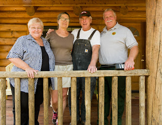
Residents of Upper Cow Creek Rd with IMT 2 Steve Bowen.
|
Southern Oregon is wildfire country. In the last five years about one-third of the 325,000-acre Tiller Ranger District has been blackened by wildfire. This year, the Stouts Creek Fire has already burned over 25,000 and was 82 percent contained on August 22, 2015. Locals here know about living with wildfire. They have learned that adapting to wildfire means getting to know your neighbors and that potlucks are the perfect place talk about being a fire-adapted community.
When the Stouts Creek Fire was threatening homes east of the community of Azalea, fire managers were pleased to learn that Milo, Tiller, and Upper Cow Creek Road were designated FireWise Communities. Being Firewise means homeowners have taken significant steps to make their homes defensible from a wildfire. After several years of hard work, 14 homes and several roads including Upper Cow Creek Rd have defensible space and have joined the dozen other recognized FireWise communities in Douglas County.
The maxim of many hands makes light work applies. Grant resources, program support and technical assistance came from the Douglas Forest Protective Association, the Umpqua National Forest, Douglas County Public Works, the Phoenix Charter School and others. At the grassroots level, neighbors did not just come together on their own. There was a spark, a catalyst, someone who overcame the inertia and fostered change. That person was Kathy Staley of Upper Cow Creek Rd.
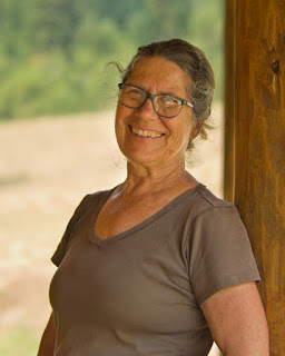 |
| Kathy Staley, community sparkplug. |
“The Umpqua National Forest is part of our community,” said Kathy Staley. “Donna Owens, Tiller District Ranger, made it easy for us. We hold regular potlucks and Donna and her staff began attending. As we got to know one another we naturally broadened our circle of care to include those who work for the Forest Service,” she explained.
“Prior to these gatherings, the relationship with the Umpqua NF was often adversarial. It helped that Ranger Owens was willing to say the tough but honest things,” Staley said. “That built trust in the eyes of the community members.”
Clearly motivated, Kathy explained that her career as an engineering inspector gave her a sharp and critical eye.
“I saw a need,” she explained. “I’m relatively new to the community. We learned that there were grants available to help pay for removing the brush and small trees to make our homes safer from wildfire,” she said. The grant funds and other monies helped pay for road crews removing roadside brush.
“Red Apple Road used to be tight with brush,” explained Kathy Pack of Upper Cow Creek Road. “It made me nervous thinking about driving it during a wildfire. Getting the roads and houses cleared of brush out really gave me piece of mind,” she said.
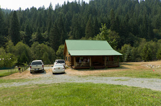 |
| Defensible space around the home of Jim and Kathy Pack. |
Once the neighbors learned that they could meet their commitment by contributing their time, the idea spread like creamy peanut butter. Using the county’s road crew and students from the Phoenix Charter School, they were able conduct defensible space activities at more than a dozen homes—removing brush and small trees and pruning up the branches on larger trees to make the homes safer from wildfire.
“We’ve owned this piece of land for 30 years,” said Jim Pack. “I planted all the trees myself and each one has a name. This place is a dream come true for me. Making it safer from wildfire was just something we had to do. We have too much at stake to live with the risk of it burning.”
Just as local residents gave their time, staff from the Tiller Ranger District understood they had to do the same. “The relationship building just took time,” said Terry Brown, Fire Management Officer, Tiller Ranger District. “The relationships we have with the community are the most valuable results from this process.”
The Douglas Forest Protective Association formed the third leg of the FireWise stool. FireWise Coordinator Dennis Sifford advises communities on becoming FireWise.
“The program helps make homeowners aware of the risks and teaches them about the little things they can do to help their homes survive a wildfire,” said Dennis.
Wildfire is a frequent visit
or to southern Oregon. Building resilience and adapting to wildfire depends on knowing your neighbors, widening the circle of care and finding the catalysts in the community who can make things happen. In these Firewise communities, these grass roots efforts have clearly paid off.
“When I learned that the residents of Upper Cow Creek Road were designated FireWise, I was more confident that we could protect the homes and that our firefighters would come home safely,” explained Steve Bowen, Structural Liason for the Stouts Creek Fire.
By: Stouts Creek Fire Information Team
Helpful Links:
http://www.dfpa.net
http://www.firewise.org
http://www.fs.usda.gov/umpqua
August 21, 2015
After three weeks of hard dangerous work, crews now have the Stouts Creek Fire fully encircled with a blackline—when the fire’s edge has burnt to a road or other fireline and is secure. Last night, fire crews completed burn out operations on the last piece of the 51-mile fire perimeter. Reaching this milestone has been the fire crews’ focus for the past week.
“I feel really good about where we are at,” said John Pellisier Operations Section Chief. “I was able to sleep easy last night knowing that we have this thing cinched up.”
While the mood at morning briefing was upbeat, fire managers reminded crews to be vigilant and stay focused on the work ahead. “Yes, we have a blackline around this fire. That’s great. And we still have lots of work to do,” said Incident Commander Chris Cline. “We need to stay focused and make sure our lines hold as the weather heats back up in coming days.”
The day shift will focus on burning interior patches of unburnt fuels near the southern tip of the fire. These operations will produce smoke for at least a couple more days. Once the burnout is secured, the evacuation level on Upper Cow Creek Road will be reduced. Until then, the evacuation levels remain unchanged.
A Level 2 Evacuation notice (Get Set) remains in place for residents on Upper Cow Creek Road east of Devils Flat to the end of the road. This precautionary measure is because of high temperatures and low humidities that might cause increased fire behavior. The Stouts Creek Fire has blackened 26,188 acres and is 80% contained and still has the potential for rapid growth. A contingency plan to protect structures on Upper Cow Creek is in place and will be activated if needed. Evacuation levels for all other areas remain at Level 1 (Get Ready).
The Stouts Creek Fire has been managed under unified command by Oregon Department of Forestry Team 2 Incident Commander Chris Cline and Forest Service Incident Commander Mike Wilde, since August 13.
There are 764 personnel assigned to the fire with 11 crews, 19 engines, 25 water tenders, 13 bulldozers and six helicopters. To date, the Stout Creek Fire has cost $33.3 million.
The Incident Management Team is protecting lands that are about 46% on state protected lands, which include BLM and private lands and 54% on the Umpqua National Forest.
August 21, 2015
Location: Rogue River-Siskiyou National Forest, 18 miles east of Gold Beach
Incident Commander: Doug Johnson
Information Center: 541-247-4447
Inciweb: http://inciweb.nwcg.gov/incident/4461Email: collierbuttefire@gmail.com
Facebook: U.S. Forest Service-Rogue River – Siskiyou National Forest
Oregon Smoke Information: http://oregonsmoke.blogspot.com/
The Curry County Fairgrounds in Gold Beach will host the Fair August 27-30 as planned. The Collier Butte Fire incident command post will be moving to the Gold Beach High School Saturday to make room for the Fair set-up.
Current Situation:
9,000 acres
30% Containment
415 Personnel
5 Crews
5 Dozers
2 Helicopters
8 Water Tenders
11 Engines
With firelines in place on the north, west and south flanks, firefighters will focus on securing containment lines by burning fuel along the fire’s edge and interior pockets within the fire perimeter. Burnout operations will also focus on the containment line between Big Craggies and the Collier Butte vicinities, and will begin only if favorable weather conditions exist. A helicopter equipped with an aerial ignition device is available to assist ground personnel by burning areas that are difficult to access.
Helicopters will shuttle crews into the Wilderness to assist in containing burnout operations. Portable water pumps and hoses remain in place to provide water support, and two heavy lift helicopters stationed in Agness will be available to drop water.
Crews and engines will continue mop up operations to extinguish burning and smoldering vegetation along the fire edge. Firefighters will improve secondary and contingency lines by falling hazard trees and removing excess fuels. These precautionary lines extend north from Forest Road 3318 to the Illinois River and south along Forest Road 1376 to the Chetco River. The fire continues spreading east into remote, inaccessible land in the Kalmiopsis Wilderness, yet remains west of the Illinois River.
Nationally, the wildfire situation remains at a critical level. All available firefighting resources are being called upon to assist, resulting in a shortage of fire crews, helicopters and support personnel. Firefighters are being reassigned to more-critical incidents to protect lives, homes and infrastructure. On the Collier Butte Fire, managers are strategically positioning available resources to focus on holding and securing containment lines, and coordinating aircraft use with other fires in southwest Oregon.
Rugged, steep terrain and an abundance of snags present challenges to firefighter safety. Due to a shortage of firefighting resources and limited wilderness access, management of this wildfire is likely to continue for an extended period. Smoke from the fire may be visible at the times throughout the remainder of the fire season.
Businesses along the south coast and Rogue River remain open and welcome visitors. Residents and visitors to Gold Beach, Brookings and nearby communities are encouraged to drive carefully as firefighter traffic has increased in the area. The public is encouraged to use caution outdoors, as extreme drought conditions persist. Fuels are receptive to any type of spark or flame. For information on closures on the Rogue River-Siskiyou National Forest, please see the Facebook page or the Inciweb page listed above.
August 20, 2015
The Oregon Department of Forestry’s Southwest Oregon District imposed a complete shutdown August 1 on public use of power-driven machinery. This shutdown includes any equipment that uses a petroleum fuel-powered, spark-emitting engine. The list of equipment this restriction affects is long, but it includes chain saws, brush cutters, mowers and generators.
This restriction does not apply to cutting irrigated green grass, or to machinery used for the commercial culture or harvest of agricultural crops. It also does not apply to industrial activities, which are currently regulated under Industrial Fire Precaution Level III (three).
The Oregon Department of Forestry’s Southwest Oregon District protects 1.8 million acres of state, private, county, and Bureau of Land Management lands in Jackson and Josephine counties. Fire season regulations also apply in county, state and BLM day-use areas and campgrounds.
For more information about the Oregon Department of Forestry’s fire season regulations, please call or visit the Southwest Oregon District unit office nearest to you:
- Medford Unit, 5286 Table Rock Rd., Central Point. (541) 664-3328
- Grants Pass Unit, 5375 Monument Dr., Grants Pass. (541) 474-3152
August 20, 2015
The Oregon Parks and Recreation Department (OPRD) is prohibiting all campfires in Oregon State Parks and other properties owned and managed by the department beginning Aug. 19 at 10 a.m. The ban includes but is not limited to designated fire pits, tiki torches and candles. The ban also extends to fires on ocean beaches.
“Our goal is to avoid any accidental fires on OPRD property that would further tax limited firefighting resources,” said MG Devereux, OPRD Deputy Director. “Most communities have sent local firefighters and equipment to help with wildfires throughout the state. An unintentional fire in a state park would add an unnecessary burden to firefighting efforts.”
The state park ban doesn’t apply to propane stoves and/or charcoal briquettes for cooking, but there may be local fire restrictions that do limit propane stoves and briquettes. Visitors planning a trip should check with park staff for the most current information, or by calling the state park information line at (800) 551-6949 or visiting www.oregonstateparks.org.
This ban will remain in effect for at least one week and will be re-evaluated based on fire status, weather, and guidance from state and local fire officials.
August 19, 2015
Crews on the Stouts Creek Fire are nearing the goal of encircling the fire with containment lines. Last night, fire crews burned out another small chunk of the fireline, leaving less than one-half mile of fireline to be completed. Once this is accomplished there will be 51 miles of fireline around this fire.
“We are very close to closing this gap and having this fire fully lined. We are getting close to connecting the firelines at the south end of the fire” said John Pellisier Operation Section Chief for the Oregon Department of Forestry.
With firefighting forces focused on the southern end of the fire the Incident Commander reminded fire crews to remain vigilant throughout the day as temperatures climb and conditions change.
“Today we will hold and strengthen our containment lines and, when the time is right, we will close the gap,” said Chris Cline, Incident Commander for ODF Team 2.
Fire weather forecasters predict today will not be as hot and dry as yesterday, however fire conditions are still extreme. As long as the inversion remains above the fire, fire activity will be low and smoke will persist. Crews will continue to patrol the fireline and mop-up any hot spots.
A Level 2 Evacuation notice (Get Set) remains in place for residents on Upper Cow Creek Road east of Devils Flat to the end of the road. This precautionary measure is because of high temperatures and low humidities that may cause increased fire behavior. The Stouts Creek Fire is 74% contained and still has the potential for rapid growth. A contingency plan to protect structures on Upper Cow Creek has been put into place and will be activated if needed. Evacuation levels for all other areas remain unchanged.
Even though personnel and equipment are needed on other fires, fire managers are keeping the resources required to meet the goals of fire containment and resource protection.
The Stouts Creek Fire has been managed under unified command by Oregon Department of Forestry Team 2 Incident Commander Chris Cline and Forest Service Incident Commander Mike Wilde, since August 13.
The fire has burned 25,324 acres and is 74% contained. There are 1,010 personnel assigned to the fire with 17 crews, 22 engines, 25 water tenders, 14 bulldozers and eight helicopters.
To date, the Stout Creek Fire has cost $31.4 million. The Incident Management Team is protecting lands that are about 48% on state protected lands, which include BLM and private lands and 52% on the Umpqua National Forest.
August 19, 2015
The Collier Butte Fire is estimated at 8,000 acres, 25 percent contained and staffed with 385 personnel. The fire is burning in the northwest region of the Kalmiopsis Wilderness and remote Rogue River-Siskiyou National Forest System lands on the Gold Beach Ranger District. Fire managers have implemented direct and indirect containment lines to protect values at risk located to the south, west, and north of the fire. Rugged, steep terrain and abundant snags present a multitude of challenges to firefighter safety. Management of this fire is likely to endure for an extended period due to the shortage of firefighting resources and the limited access in the Kalmiopsis Wilderness.
Firefighters plan to burnout along Forest Road 3680 in order to strengthen the fireline. A smoke inversion is expected again today delaying burnout operations until afternoon. Winds are expected to be light from the northeast, switching to northwest later in the day. Firefighters will patrol and mop-up containment lines and watch for possible reburn due to falling tree needles accumulating in recently burned areas. Fuels reduction and chipping will take place along Forest Road 3318 today and along dozer line in the southern portion of the fire.
There are approximately 100 uncontained large fires in the nation resulting in a scarcity of resources. Crews, aircraft and qualified support personnel are in high demand and short supply. High-priority values at risk on other fires are in need of vast numbers of resources to protect lives, homes and infrastructure. Firefighting resources are being reassigned and moved to protect these values. Collier Butte Fire managers are strategically positioning available resources to focus on holding and securing primary and alternate containment lines. Additionally, aviation managers are coordinating the sharing of aircraft with other fires in southwest Oregon.
Closures:
Businesses along the south coast and Rogue River remain open and welcome visitors. Residents and visitors to Gold Beach, Brookings and nearby communities are encouraged to drive carefully as firefighter traffic in the area has increased.
The Curry County Fair in Gold Beach will take place Aug. 27-30 as planned.
August 19, 2015
Fire season in southwest Oregon continues to be extraordinarily hot and dry, and the Oregon Department of Forestry is committed to reducing the number of human-caused fires in forests and other wildland areas in Jackson and Josephine counties.
Releasing sky lanterns during fire season is one activity that is not allowed on ODF-protected lands. Fire season began June 5.
A sky lantern is commonly made of a lighted candle suspended beneath a plastic bag. The heat rising from the candle inflates the bag, which floats away and eventually returns to earth. If the lighted candle comes in contact with dry vegetation, a wildfire is likely to start.
The Oregon Department of Forestry’s Southwest Oregon District protects 1.8 million acres of state, private, county, and Bureau of Land Management lands in Jackson and Josephine counties. Fire season regulations also apply in county, state and BLM day-use areas and campgrounds.
For more information about the Oregon Department of Forestry’s fire season regulations, please call or visit the Southwest Oregon District unit office nearest to you:
- Medford Unit, 5286 Table Rock Rd., Central Point. (541) 664-3328
- Grants Pass Unit, 5375 Monument Dr., Grants Pass. (541) 474-3152
August 19, 2015
The Industrial Fire Precaution Level (IFPL) will increase to IFPL IV (four) on Saturday, August 22, 2015, at 12:01 a.m. for the entire Rogue River-Siskiyou National Forest.
On Oregon Department of Forestry-protected lands in Jackson and Josephine counties, IFPL III (three) is in effect.
Under IFPL IV, known as “General Shutdown”, all industrial actions are prohibited. This includes any personal and commercial use, firewood permits, power saws, and yarding.
Public use restrictions remain in effect, limiting the use of campfires to fire rings within designated campgrounds. No fires are permitted in wilderness. Current Public Use and Wilderness Restrictions can be found at http://www.oregon.gov/odf/pages/fire/precautionlevelmap.aspx
For more information, contact the Rogue River-Siskiyou National Forest at (541) 618-2200. For current information on IFPL levels, visit the Medford Interagency Communications Center website at http://ormic.org/fire_danger.shtml. Rogue River-Siskiyou National Forest fire prevention regulations are posted online at www.fs.usda.gov/rogue-siskiyou.
Please contact your local Ranger District office for more information and maps prior to travel on National Forest lands:
- Supervisor’s Office, Medford, (541) 618-2200
- Gold Beach Ranger District, (541) 247-3600
- High Cascades Ranger District
- Prospect, (541) 560-3400
- Butte Falls, (541) 865-2700
- Powers Ranger District, (541) 439-6200
- Siskiyou Mountains Ranger District (541) 899-3800
- Wild Rivers Ranger District
- Grants Pass, (541) 471-6500
- Cave Junction, (541) 592-4000


