Avoid Target Shooting in Dry Grass

As persistent dry conditions continue across southwest Oregon, the Rogue River-Siskiyou National Forest is moving to “Extreme” fire danger, effective immediately.
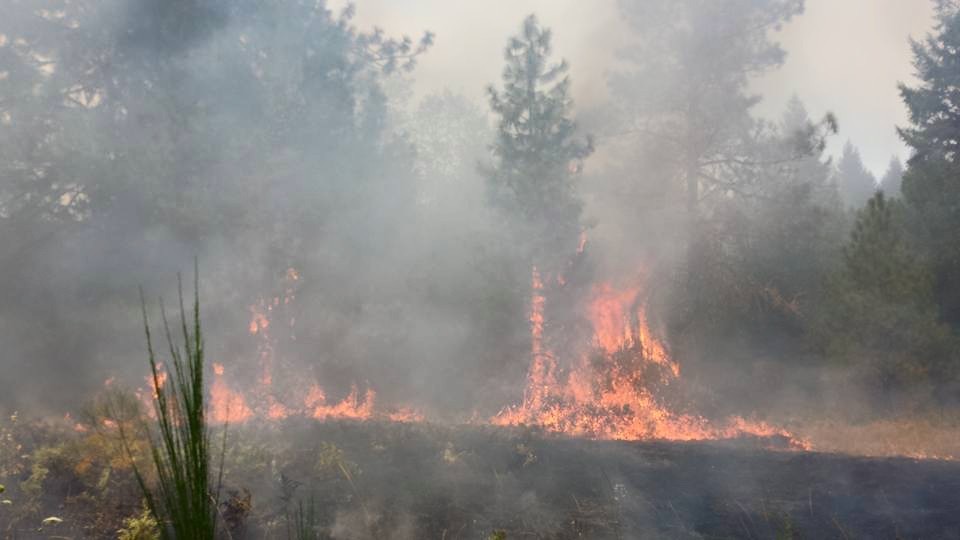
Fire agencies in southwest Oregon are urging caution for all those participating in outdoor activities this season. Just one small spark from an unattended fire, muzzle of a gun, or the hot exhaust pipe on a vehicle can ignite fine fuels.
Current information on the National Creek Complex and the Collier Butte Fire, both burning on the Rogue River-Siskiyou National Forest, is available online at http://inciweb.nwcg.gov/. Additional online resources for fire conditions and fire information are available at http://ormic.org/.
For more information on current fire restrictions, call (541) 618-2200.
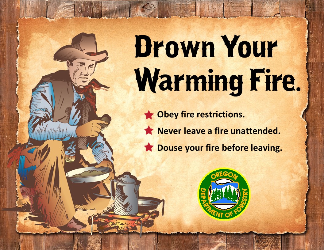
As the sun sets on your outdoor family vacation, a campfire is a great place for sharing your adventure over a melting marshmallow on stick. Whether you’re cooking, warming up, or just sitting and enjoying the crackle and glow, campfire safety is a must. Before you light that fire here are a few campfire tips:
Building a Safe Campfire
Putting Out a Campfire
For up-to-date info on the National Creek Complex, see National Creek Complex blog and Facebook page.
Crater Lake National Park has closed the north entrance road between State Highway 138 at the park’s north boundary and Crater Lake west rim drive at north junction. This precautionary closure will facilitate fire operations and provide for the safety of firefighters and park visitors. A segment of the Pacific Crest Trial is also closed from the park north boundary to the junction with Lightning Springs Trail.
Yesterday’s Activities: The size of the National Fire remains unchanged as crews continued to search for and extinguish hot spots near containment lines. Firefighters are preparing existing Forest Service roads to be used for containment lines west of the National Fire should they be needed for the Crescent Fire. Other crews constructed hand fire lines perpendicular to and south of Highway 230 to create opportunities for checking the spread of the fire.
The Crescent Fire increased by over 500 acres yesterday. Crews also responded to and suppressed another spot fire north of Highway 230.
Today’s Activities: Fire crews will continue to improve State Highway 230 for use as a containment line west of the fire. Burn out operations may begin at the north eastern part of the fire. Crews will also continue to improve or remove dead trees along the north park entrance road further south in anticipation of the fire pushing to the east. A structure protection group, supported by initial attack resources, is working in the Diamond Lake area to protect structures.
Weather: Warmer and drier temperatures are expected today and are predicted to increase during the next few days. The relative humidity is expected to be near 15 – 19% this afternoon with no substantial winds.
The weather on Tuesday and Wednesday is expected to create very active fire behavior conditions. An inversion layer has been mitigating the fire intensity for the past few days on the northern part of the fire by trapping smoke near the ground level and shading vegetation. These conditions are expected to change and with better air ventilation, an increase in fire behavior will occur.
Closures & Evacuations: Crater Lake National Park has closed the north park entrance and a larger section of the Pacific Crest Trail, north of the lake. The remainder of the park is open. Area closure orders have been issued for the Rogue River-Siskiyou and Umpqua National Forests near Diamond Lake. Maps and descriptions of the trail and area closures are online at http://inciweb.nwcg.gov/incident/4463/.
State Highway 230 is closed (ODOT Tripcheck). There are trail closures in the National Park and on the Rogue River-Siskiyou and Umpqua National Forest.
Diamond Lake Area is under a Stage 1 Evacuation Notice; the “ready” stage in “ready, set, go”.
This fire is not 100 percent contained and still has the potential to grow rapidly, therefore residents in the Upper Cow Creek east of Devils Flat to the end of the road are advised that the evacuation level has been raised to a Level 2 (Get Set). This is a precautionary measure is due to high temperatures and low humidities.
At approximately 7:00 pm tonight fire crews will take advantage of weather conditions and topography to conduct a burnout operation along the established bulldozer lines in the southeast portion of the fire. This area has been prepared well in advance for this operation.
During day operations crews were assisted by heavy lift helicopters cooling hot spots and flare-ups as temperature steady rose throughout the day. The firing operation conducted on Sunday evening was highly successful; the fire continues to back away from containment lines and crews were able to mop up into the perimeter through the day.
Expected warmer and drier conditions on Tuesday will restrict any firing operation as the relative humidity will be in the low teens and temperatures will reach into the mid-eighties. Existing lines will be tested and fire crews will need to remain vigilant as interior burning will be more active. There is a greater probability of embers being carried aloft as the fire burns more intensive. While fire managers are confident, they have a plan to deal with contingencies and have the ground forces and helicopters to attack any fire that escapes.
Throughout the night, patrols will continue monitoring the firelines on the west, north and east sides and addressing any flare ups that are encountered.
Even though resources are needed on other fires, fire managers are keeping as many resources as needed to maintain the integrity of completing the objectives.
The Stouts Creek Fire has been managed under unified command by Oregon Department of Forestry Team 2 Incident Commander Chris Cline and Forest Service Incident Commander Mike Wilde, since August 13.
The fire has blackened 24,756 acres and remains 70% contained. There are 1,120 personnel assigned to the fire with 27 crews, 23 engines, 20 water tenders, 19 bulldozers and 9 helicopters.
To date the Stout Creek Fire has cost $29.5 million. The Incident Management Team is protecting lands that are about 48% on state protected lands, which include BLM and private lands and 52% on the Umpqua National Forest.
Using a helicopter to drop buckets of water on a wildfire is very helpful to firefighters. This video is taken from the pilot’s perspective, a view most people don’t get.
Sunday’s preparation for the burnout operations allowed the night crews to continue what was started late in the afternoon. Overnight crews working on the southwest side of the fire, from DP 69 to Newman’s Gap, were able to make significant progress. Using established fireline, crews were able to use low-intensity burn methods to widen the line as much as 50-75 yards. The day shift will continue these efforts to build and strengthen this line.
With warming temperatures and lowering humidity, fire activity has the potential to increase. Because of these conditions, crews will continue monitoring the firelines on the west, north and east sides and address any flare ups that are encountered.
The Stouts Creek Fire has been managed under unified command by Oregon Department of Forestry Team 2 Incident Commander Chris Cline and Forest Service Incident Commander Mike Wilde, since August 13.
The fire has blackened 24,756 acres and 70% contained. There are 1,144 personnel assigned to the fire with 22 crews, 24 engines, 26 water tenders, 19 bulldozers and 6 helicopters. Numbers of personnel and equipment will continue to shrink as objectives are met and these resources move on to assist with many of the other fires in the state and geographic area.
To date the Stout Creek Fire has cost $29.5 million. The Incident Management Team is protecting lands that are about 48% on state protected lands, which include BLM and private lands and 52% on the Umpqua National Forest
Night crews on the Stouts Creek Fire continued to be vigilant, holding and widening control lines while working toward securing the south end of the fire. Overnight fire activity was low as firefighters patrolled the northern portions of the 24,181-acre fire looking for hot spots and flare ups. The fire is 65% contained.
Using heavy equipment, crews have completed the majority of the containment line on the south end in preparation for the large burnout, north of Upper Cow Creek Road and Beaver Creek. Firefighters will install hoses, pumps and tanks as mangers wait for favorable conditions to complete the next phase. Based on current progress and weather forecasts, that burnout could begin in the next few days.
“We should have the line completed today,” said John Pellissier, Operations Chief for the fire. “We’re about 2/3 done with the mechanical work and then we’ll run hose and water sources throughout. Operationally, we’ll be ready. Then it’s up to Mother Nature.”
Fire managers are looking for weather conditions that will allow for a safe, slow burn that will minimize impact on timber and other natural resources. With many factors involved in the burn operations, any number of things out of parameters could delay the burnout.
“All of the weather conditions and other factors have to be right,” Pellissier said. “We are looking to start with a smaller, slow trial process and this could take several days. It will be a slow, steady process.”
The public will be given as much notice before the burnout begins as possible.
There are 1,645 personnel assigned to the fire with 49 crews, 46 engines, 27 water tenders, 20 bulldozers and 11 helicopters. Numbers of personnel and equipment will continue to shrink as objectives are met and these resources move on to fires with greater needs.
The Stouts Creek Fire costs to date are $25.5 million. The Incident Management Team leading the effort under unified command is protecting lands that are about 48% on state protected lands, which include BLM and private lands, and 52% on the Umpqua National Forest. Twenty-three states and three Canadian provinces have provided staff for this effort.
At about 24,000 acres and nearly 60 percent contained, firefighters will continue working through the night on the southern areas of the Stouts Creek Fire. Today, firefighters conducted burnout operations and prepared other areas for future burnouts, particularly north of Upper Cow Creek Road and Beaver Creek.
With lower relative humidity and higher temperatures today, fire activity increased in some areas. These weather conditions will likely help the crews fighting the fire’s south side to conduct effective burnouts, which removes the brush, trees and other fuel, on smaller acreage to eliminate the fuel and assist with working towards containment. On the north side, crews will continue eliminating heat to improve control lines.
“This has been a tough, ugly fire,” Incident Commander John Buckman during Wednesday’s night shift briefing. “It’s only because you’ve persistently and safely fought this fire for 14 straight nights that we’ve made significant progress. Thank you for your dedication to the surrounding communities. Keep persevering.”
All evacuation levels are at Level I.
With continued smoke in the area, those with health concerns should talk to their doctor or go to www.oregonsmoke.blogspot.com. There they will find information on wildfires and health as well as access to Air Quality Index monitors. Motorists are urged to be careful driving through smoke on the roads, and turn on their low beam headlights. Residents and travelers also are asked to not stop along Tiller-Trail Highway to view fire or helicopter activity as traffic is heavy with response vehicles.
There currently are 1,693 personnel assigned to the fire with 62 crews, 53 engines, 30 water tenders, 23 bulldozers and 16 helicopters.
The Stouts Creek Fire costs to date are $22.4 million. The Incident Management Team leading the effort under unified command is protecting lands that are about 50 percent on state protected lands, which include BLM and private lands, and 50 percent on the Umpqua National Forest. Twenty-three states and three Canadian provinces have provided staff for this effort. The fire is being managed cooperatively by the Oregon Department of Forestry and the U.S. Forest Service. The Oregon Department of Forestry’s Incident Management Team 1 develops and leads the wildland fire suppression strategy.
The Incident Command Post, previously located at Days Creek Charter School, was moved to the main camp west of Days Creek.
Making significant headway connecting the Stouts Creek Fire’s control lines Sunday night, firefighters finished burning out an area along the fire’s north and east sides along Hatchet Creek. Other crews along the Tiller-Trail Highway from milepost 30 to 35 crews walked the fire down to the control lines. They now will begin strengthening those lines. Heavy equipment operators maneuvered a half-dozen pieces of equipment along Forest Road 2301 to strengthen that contingency line overnight.
Type 2 Initial Attack (T2IA) crews from Oregon, Massachusetts, Ohio and West Virginia with expertise conducting burnout operations and falling large trees arrived last night. These crews are heading to the fire line today for operations the south and east sides of the fire. The Santa Fe Hot Shots will attempt a burnout operation about one mile north of Cow Creek Road near Beaver Creek.
The Incident Meteorologist reported a Red Flag Warning because of lightning potential which might be accompanied by rain, wind gusts and hail during the next 24 hours. He called for wind shifts from the south and southeast this morning to the west and northwest this afternoon. As crews continue conducting burns over the next few days and weeks to contain the fire residents, will see more smoke.
Today’s work will focus on strengthening lines along the southern part of the fire to prepare for a large burn. Forest Roads 32, 3201 and 3230 would be used to hold a fairly large burnout planned for next week.
Those with health concerns should talk to their doctor or go to www.oregonsmoke.blogspot.com where there is information on wildfires and health as well as access to AQI monitors. Motorists are urged to be careful driving through smoke on the roads, and turn on their low beam headlights. Residents and travelers also are asked to not stop along Tiller-Trail Highway to view fire or helicopter activity as traffic is heavy with response vehicles.
Evacuation levels remain unchanged. Drew is the only area on evacuation Level II from milepost 28 through milepost 39. The Douglas County Sheriff’s office is monitoring that designation.
The Stouts Creek Fire costs to date are $17 million. The state and national teams leading the effort under unified command are protecting lands that are about 50 percent on state protected lands, which include BLM and private lands, and 50 percent on the Umpqua National Forest. The fire is being managed cooperatively by the Oregon Department of Forestry and the U.S. Forest Service. The Oregon Department of Forestry’s Incident Management Team 1 develops and leads the wildland fire suppression strategy.
The Krauss Lane Fire, 5 miles south of Cave Junction, has been deemed human caused and is currently under investigation. The fire started around 1:30 PM at the 100 block of Krauss Lane on August 8. Upon arrival, units reported the fire to be 2-4 acres with immediate structural threat to 50 homes. Command requested a second alarm that initiated Rural Metro Fire resources as well as other agencies. Both Rogue Valley Task Force 1 and 2 were activated and requested on scene as the fire continued to spread. ODF requested helicopters, tankers, tenders, crews and engines to stop the spread of fire.
The fire grew to a total of 58 acres and destroyed one outbuilding and six vehicles. Night operations continued through this morning, and crews will continue mopping-up and move to gridding by the end of the day. Depending on how work progresses, night operations may not be necessary through the night.
The fire currently has a Type 1 helicopter, (1) 10- person handcrew, (1) 20-person handcrew and six engines. Once mop-up and gridding are complete, crews will check the fire for three straight days to insure there are no smokes or smoldering areas. Within that three day period, if they find any smokes, they will restart their three day watch until they have three continues days without smoke.
Today’s conditions will continue to be hot and dry. We will be in a red flag warning from 2PM Monday to 1 AM Tuesday for scattered thunderstorms.

Around 1:30 PM, Illinois Valley Fire Department, Oregon Department of Forestry (ODF), and US Forest Service responded to a reported grass fire located in the 100 block Krauss Lane. Upon arrival, units reported the fire to be 2-4 acres with immediate structural threat. Command requested a second alarm that requested Rural Metro Fire resources as well as other agencies. Both Rogue Valley Task Force 1 and 2 were activated and requested to the scene as the fire continued its forward rate of spread. ODF requested helicopters and tankers to the fire to stop the forward rate spread of the fire. At times we have had 6 helicopters actively working the fire as well as 3 air tankers. There are numerous resources on scene. We have an information table setup at Shop Smart located at 205 West Watkins that has maps of the currents areas of evacuation and current updated information. The fire acreage is currently at 40 acres.
At this time, all evacuations have been lifted and the Red Cross shelter is closing. For continued updates, please call 541-592-2225.

The Krauss Lane Fire is currently a fire burning near Cave Junction. The fire originated on the south side of the river in Cave Junction. The fire has recently jumped the river and has grown to 25 acres in size. Josephine County Emergency Services and Oregon Department of Forestry have issued a Level 3 “GO NOW” evacuation order for all Patton Bar Road, Ken Rose, Ivy Road, Logan Cut, Simmons Cuts Road, Mesa Verde, Fernwood, and White Oak residents in Cave Junction. All residents are urged to evacuate immediately. There may be no time for further warning.
A LEVEL 3 evacuation means that you need to LEAVE IMMEDIATELY! Danger to your area is current or imminent, and you should evacuate immediately. If you choose to ignore this advisement, you must understand that emergency services may not be available to assist you further. DO NOT delay leaving to gather any belongings or make efforts to protect your home.
There is an information line set up Illinois Valley, you can reach it at 541-592-2225.
Friday’s night crews continued to make significant progress on the Stouts Creek Fire with several areas of the fire in the mop up stages and containment increasing to 30%. Now at 21,858 acres, the fire remains active on the northeast and southeast edges of the perimeter and residents can expect to see smoke and possibly flames on the ridge above Tiller-Trail Highway.
Helicopters will continue to be visible along the South Umpqua River as they work on hot spots and in support of fire fighting activities. Residents¬¬ also might see air tankers working in addition to the helicopters depending on the fire activity level. Motorists are encouraged to use extreme caution if they encounter smoke on roadways. Treat it as you would fog and turn on your headlights. We encourage those wanting to stop along the road to watch the firefighting efforts to continue moving in order to maintain traffic flow along the roadway.
The Upper Cow Creek Road and Milo area, as well as a small area along the Tiller-Trail Highway north of Trail in Jackson County, are under a Level 1 (Ready) evacuation alert. Drew (milepost 28 to 39) remains at Level 2 (Set).
Structure protection resources and the OSFM Green Team personnel demobilized today after determining that protection benchmarks were met. Mitigation efforts included creating defensible space around threatened homes, fuel chipping, strategic placement of portable water tanks and pumps and placement of sprinkler kits where necessary. Fire managers also ensured that a structure protection plan is in place for both the assigned wildland resources and county fire agencies. Two structure task forces from Douglas County are available if needed.
More than 1,500 personnel are assigned to the fire suppression effort. The cost of suppression so far is $12.1 million.
The Stouts Creek Fire is burning on private timberlands, other tracts of private land, Bureau of Land Management and Umpqua National Forest lands.
The Stouts Creek Fire is being managed cooperatively by the Oregon Department of Forestry and the U.S. Forest Service. Wildland fire suppression direction is coming from the Oregon Department of Forestry’s Incident Management Team 1.
Night crews continued to work on the flare-up of the east flank of the Stouts Creek Fire. The fire actively burned in this area till 3:00 am. Crews were able to maintain the fire within the constructed hand dug lines south of the 3220 road and west of the Tiller-Trail Highway.
A structure protection task force, comprised of engines protected homes near the community of Drew. A second task force of engines from structural protection fire districts in Jackson County arrived last night to provide additional structure protection. Both task forces are working a flex schedule to maximize protection during the afternoon and evening burning periods. The tasks forces are under the direction of an Oregon State Fire Marshal incident management team.
Fire activity around the rest of the 20,804-acre Stouts Creek Fire was relatively calm overnight. Mop-up continued along the north and west flanks. Fire line construction also continued along the lower portion of the west flank, the south flank and portions of the east flank. Heavy equipment being used includes bulldozers, excavators and feller-bunchers. The equipment is not only building a wide fire line but is removing excess trees and brush adjacent to the line. Where the heavy equipment cannot work, due to steep terrain, fire crews are building fire line by hand.
The fire is 25 percent contained. 1,545 personnel are assigned to the fire suppression effort.
The cost of suppression so far is $10.4 million.
The evacuation levels in the Upper Cow Creek Road area, Milo and Drew remained at Level 2 (Set). A small area along the Tiller-Trail Highway north of Trail in Jackson County is under a Level 1 (Ready) evacuation alert.
Smoke will continue to drift from the fire area and will be stronger when burnout operations are taking place. Most of the smoke will drift in a south/southeast direction from the fire. For updates on smoke density and public health advisories, see www.oregonsmoke.blogspot.com.
The Stouts Creek Fire is burning on private timberlands, other tracts of private land, Bureau of Land Management and Umpqua National Forest lands.
The Stouts Creek Fire is being managed cooperatively by the Oregon Department of Forestry, the Office of the Oregon State Fire Marshal and the U.S. Forest Service. Wildland fire suppression direction is coming from the Oregon Department of Forestry’s Incident Management Team 1. Structural fire protection is being handled by task forces under the command of the Oregon State Fire Marshal’s Green Team.
Much of today’s fire suppression focus on the Stouts Creek Fire is on connecting fire lines and doing burnout operations along the east and south flanks. Crews on the fire’s west and north flanks are running hose lays and doing mop-up along the fire’s edge. Some burnout operations are also being conducted along the west side.
The fire has grown to 17,500 acres. Most of the increased size is due to fireline relocation and burnout operations. The fire is 15 percent contained.
Helicopters will be seen much of the day over the Stouts Creek Fire because the smoke has cleared out allowing the aircraft to fly earlier than normal. Seven helicopters are assigned to the incident for fire suppression support. Another helicopter is on standby to respond to medical emergencies. Air tankers are available on an as-needed basis.
The evacuation levels in the Upper Cow Creek Road area, Milo and Drew remained at Level 2 (Set). A small area along the Tiller-Trail Highway north of Trail in Jackson County is under a Level 1 (Ready) evacuation alert.
A task force of structural fire protection engines is in place in the Upper Cow Creek Road area and another task force is stationed in the Drew area. Residences and other structures have been evaluated for defensible space. Vegetation reduction has been completed in many areas to make homes more defensible against fire. Portable water ponds, pumps, hoses and sprinklers have been stationed in several areas among the homes.
Smoke continues to drift from the fire area and will be stronger when burnout operations are taking place. Most of the smoke will drift in a south/southeast direction from the fire. For updates on smoke density and public health advisories, see www.oregonsmoke.blogspot.com.
Good progress was made during day shift on the 17,166-acre Stouts Creek Fire, burning in rugged, densely forested country 16 miles east of Canyonville in Douglas County. Hoses were being strung down the miles-long western flank of the fire and mop-up was underway in that part of the fire. Mop-up was also continuing along the northern edge of the fire. Crews on the east and south flanks were punching in fire line with bulldozers and other heavy equipment. In areas where equipment could not be used, fire line was being dug by crews.
The evacuation levels in the Upper Cow Creek Rd. area, Milo and Drew remained at Level 2 (Set). A small area along the Tiller-Trail Highway north of Trail in Jackson County is under a Level 1 (Ready) evacuation alert.
The Stouts Creek Fire is burning on private timberlands, other tracts of private land, Bureau of Land Management and Umpqua National Forest lands.
The fire is 10 percent contained. Nearly 1,600 personnel are assigned to the fire, and crews are working day and night shifts.
The cost of the fire suppression effort to date is $4.4 million.
Spot fires along the east and southeast flanks of the fire today prompted action from several of the helicopters assigned to the fire. They dropped water onto the spot fires and crews worked to keep them as small as possible.
Elsewhere, as crews completed stretches of fire lines, burnouts were conducted to consume unburned vegetation on the ground between the fire lines and the edge of the wildfire. Night shift crews will continue fire line construction and burn out in portions of the south and east flanks.
The Stouts Creek Fire is being managed cooperatively by the Oregon Department of Forestry, the Office of the Oregon State Fire Marshal, and the U.S. Forest Service. Wildland fire suppression direction is coming from the Oregon Department of Forestry’s Incident Management Team 1. Structural fire protection is being handled by task forces under the command of the Oregon State Fire Marshal’s Green Team.
On Monday, firefighters took advantage of favorable weather conditions by constructing fire lines and conducting burn out operations. The fire increased to 17,166 acres as crews burned out vegetation to help protect a communications site and reinforce dozer and hand lines. Last night, crews were able to put in more miles of line than expected. Fire officials stated that four or five more days as productive as yesterday will make a difference.
“Good progress has been made, we’ve gained a foothold,” said Bill Hahnenberg of the US Forest Service, one of the Incident Commanders with the unified command managing the fire.
The fire is 10% contained with 1,272 people working on this incident representing multiple local, state, and federal natural resource and fire service agencies. The incident has an excellent safety record despite the difficult terrain and extremely hot and dry weekend weather.
The weather forecast projects continued favorable conditions that should help firefighters make gains on containing the fire. Smoke and flames from burn out operations are expected to be visible from Tiller and Drew areas. Structural firefighters are providing “point-protection” as needed around residences adjacent to the fire. The smoke inversion that has been a regular occurrence on this incident is expected to lift by mid-day, allowing additional air support available to firefighters.
The Oregon State Fire Marshal Green Team, Oregon Department of Forestry Team 1, Roseburg Resources and other landowners, and structural fire resources from Lane, Linn/Benton, Lincoln, and Marion counties are working with dozens of private contract crews on the Stouts Fire. The Red Cross evacuation shelter in Canyonville has closed, but staff remains on call in case circumstances change. Contingency plans are in place to open a shelter on the eastern or southern end of the fire if necessary.
Evacuations Levels 1 and 2 remain in effect for 317 homes. Evacuation Level 1 (Ready) is in place for the Milo Academy area and three residence along the Tiller Trail Highway in Jackson County. Level 2 (Set) evacuations are in place along the Upper Cow Creek Road on the south side of the fire; Ferguson, Stouts Creek, and Conley lanes on the north side; and the Drew Valley along the Tiller Trail Highway from milepost 28 to 39 on the east side. No Level 3 (Go) evacuations are in place at this time.
For more information about the Stouts Fire:
Two new fires ignited by lightning overnight in the remote Kelsey Creek drainage north of the Rogue River in far northeast Josephine County have been aggressively attacked by firefighters of the Oregon Department of Forestry’s Southwest Oregon District. Hand crews, bulldozers, engines, and helicopters have successfully established a fireline around the seven acre East Kelsey Fire with mop-up operations in progress. The Trappers Camp Fire, also estimated at seven acres in size, is currently 60% lined. Firefighters will continue to work on both of these fires through the night in order to achieve full containment as quickly as possible.
Firefighters had a good day Sunday, as moderating weather conditions created calmer fire behavior on the Stouts Fire. Crews took advantage of the lower temperatures, higher humidity, cloud cover, and smoke inversion to build additional fire line, prepare contingency lines, and assess the areas around structures that need clearing and starting work to help protect them if the fire moves that way. The fire grew slightly but remains just over 15,000 acres, and is estimated at 5% containment. About 1400 firefighters continue fighting the Stouts Fire around the clock. Over 160 community members turned out to last night’s meeting at the Milo fire hall.
Working together protecting homes, the wildland firefighters will start clearing road systems and constructing line along the east side of the fire today, while the structural firefighters keep working around homes clearing the areas to help prevent a wildfire from harming homes. Smoke remains heavy and may start lifting around noon. The crews are using the weather to their advantage to make some gains on the fire.
“The crews are doing an excellent job,” said Roseburg Resources Forestry Manager Mark Wall. “They are literally working night and day to get this thing under control. No doubt, this is a difficult job, but I’m confident it’ll get done as quickly as possible and most importantly, safely.”
The Oregon Department of Forestry, the Oregon State Fire Marshal, and the USDA Forest Service Stouts Fire continue managing this fire under unified command. The Incident Management Teams representing these agencies train together, work together, and cooperate together under the Incident Command System (or ICS). The fire is burning approximately 1/3 on private land, 1/3 on Bureau of Land Management land, and 1/3 on National Forest land.
The Oregon State Fire Marshal Green Team, Oregon Department of Forestry Team 1, Roseburg Resources and other landowners, dozens of private contract crews, and structural firefighters from Clackamas, Lane, Linn/Benton, Lincoln, Marion and Yamhill counties continue fighting the Stouts Fire.
The number of structures threatened is 317. Evacuation Level 1 (Ready) is in place for the Milo Academy area and three residence along the Tiller Trail Highway in Jackson County. Level 2 (Set) evacuations are in place along the Upper Cow Creek Road on the south side of the fire; Ferguson, Stouts Creek, and Conley lanes on the north side; and the Drew Valley along the Tiller Trail Highway from milepost 28 to 39 on the east side. No Level 3 (Go) evacuations are in place at this time. The Red Cross evacuation shelter remains at the Canyonville YMCA.