July 30, 2026
Mop up and suppression repair continue across East Evans Creek Fire
SAMS VALLEY, Ore. – Firefighters continued making steady progress Wednesday as crews worked through the fire area extinguishing remaining hotspots. Overnight, relative humidity recoveries reached the 80 to 90 percent range, and cooler temperatures created favorable conditions for mop up operations.
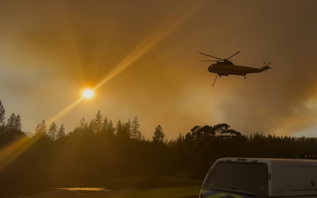
An infrared-equipped UAS mapped areas of lingering heat across the fire, helping firefighters quickly locate hotspots not visible from the ground. On the south side of the fire in the Dry Creek area, the UAS identified a few hotspots within the 300-foot mop up zone, where crews quickly extinguished the remaining heat. Light interior smoke will continue as isolated pockets of heavy fuels slowly burn within the fire perimeter.
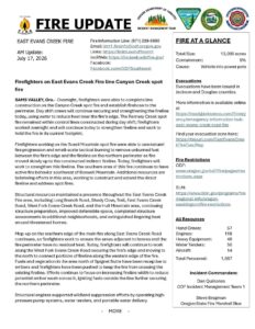
The fire remains at 15,580 acres and is 78% contained. Firefighters continue mop up operations while conducting daily reconnaissance of the fire, backhauling hose and equipment from areas where it is no longer needed, and completing suppression repair. Chippers also remain active, processing brush and small trees removed during suppression activities.
Today’s forecast calls for warm, dry conditions with temperatures in the mid-80s to around 90 degrees, low relative humidity, and gusty afternoon breezes. Firefighters will continue extinguishing remaining hotspots and strengthening containment lines where needed.
Flying a drone near or around a wildfire is illegal, compromises the safety of both pilots and firefighters, and interferes with firefighting efforts.
July 29, 2026
Firefighters continue systematic search for remaining hotspots on East Evans Creek Fire
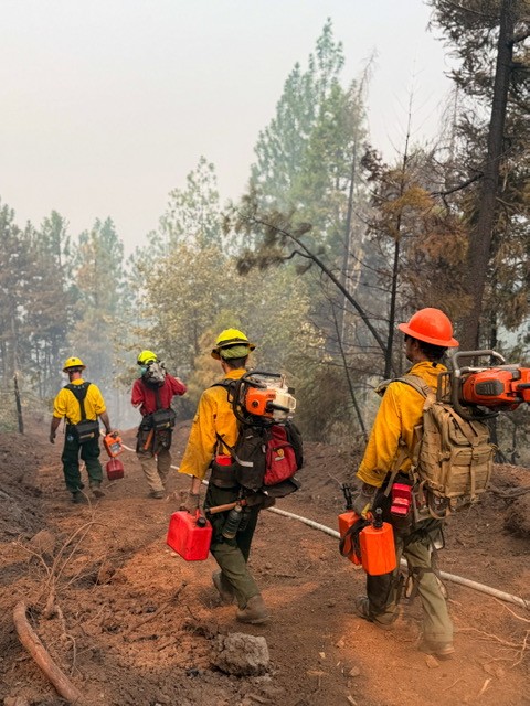
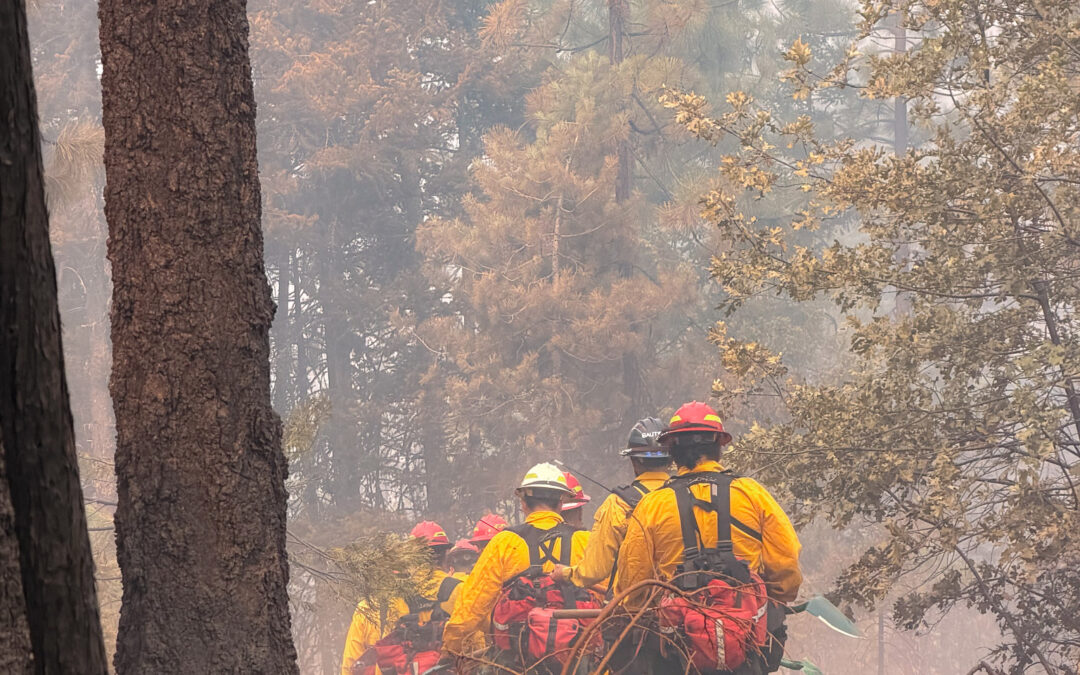
SAMS VALLEY, Ore. – Firefighters continued making steady progress across the East Evans Creek Fire on Monday, with crews focused on systematically gridding the fire area to locate and extinguish remaining hotspots. Hidden heat can continue to smolder beneath logs, root systems, and other heavy fuels long after flames are no longer visible, so firefighters carefully expose and extinguish each hotspot to eliminate any potential for reignition.
Overnight, firefighters took advantage of good humidity recoveries to continue mop-up operations while an Uncrewed Aircraft System (UAS) with infrared technology mapped remaining heat across the fire. The infrared imagery allows crews to quickly identify and attack hotspots that may not be visible from the ground. Light interior smoke will continue as isolated heavy fuels slowly burn within the fire perimeter.
The fire remains at 15,580 acres and 66% contained. Three chippers are also working throughout the incident today; processing brush and small trees cut during suppression efforts as firefighters continue suppression repair and remove equipment from areas where it is no longer needed.
Tuesday’s weather will again be warm and dry, with temperatures in the mid-80s to around 90 degrees and low relative humidity. Firefighters will continue gridding for remaining heat, strengthening containment lines where needed, and advancing mop-up operations across the fire.
Flying a drone near or around a wildfire is illegal, compromises the safety of both pilots and firefighters, and interferes with firefighting efforts.
July 29, 2026
Florida Complex Incident Management Team 1 takes command of the East Evans Creek Fire
SAMS VALLEY, Ore. – Firefighters made steady progress Sunday, reinforcing containment lines, conducting suppression repair, and completing more than 300 feet of mop‑up adjacent to the fire perimeter in many areas. On the western side, crews continued removing hose and equipment no longer needed.
Overnight, firefighters took advantage of good overnight relative humidity recoveries to continue mop-up operations while a UAS with infrared capability mapped heat near the fireline to support today’s mop‑up efforts. Light interior smoke remains as pockets of unburned vegetation continue to smolder.
The fire is 15,580 acres and is 66% contained. Containment reflects the increased depth of cold black firefighters are gaining as they grid along the fire’s edge feeling for heat and looking for smoke.
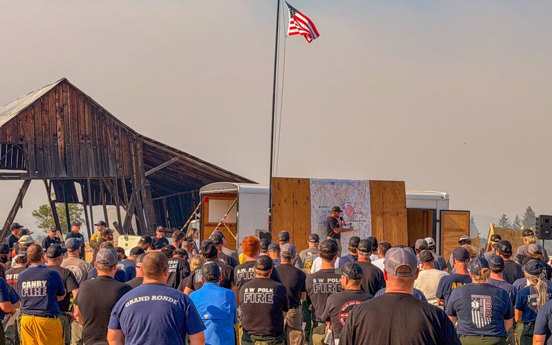
At 6 a.m. Monday, the Florida Complex Incident Management Team 1, led by Incident Commander Butch Galbraith, assumed command of the East Evans Creek Fire.
Monday’s weather will again elevate fire conditions, with mid‑ to upper‑80s temperatures and breezy winds. Firefighters will watch for changes and remain ready for any new starts.
Flying a drone near or around a wildfire is illegal, compromises the safety of both pilots and firefighters, and interferes with firefighting efforts.
July 26, 2026
Please Note New Incident Information Phone Number
Steady progress on East Evans Creek Fire increases containment
SAMS VALLEY, Ore. – Saturday, firefighters continued making progress strengthening containment lines on the East Evans Creek Fire, with more than 200 feet of mop-up adjacent to the fire perimeter in many areas of the fire. On the western edge of the main fire, crews have begun to pull hose and equipment that is no longer needed for mop-up activities.
Firefighters remained vigilant overnight, patrolling the fire area for any signs of smoke. An Unmanned Aircraft System (UAS) with infra-red capability mapped areas of heat adjacent to the fireline for firefighters to focus on today as they continue mop-up. Smoke continues to be visible in the interior as fire smolders and creeps in islands of unburned vegetation and fuels, with isolated torching in some places.
The fire is 15,580 acres and is 54% contained. Containment reflects the increased depth of cold black firefighters are gaining as they grid along the fire’s edge feeling for heat and looking for smoke.
Monday morning at 6 a.m. Oregon Department of Forestry’s (ODF) Complex Incident Management Team 1 (CIMT), Incident Commander Dan Quinones, will transfer command of the fire to Florida Complex Incident Management Team 1, Incident Commander Butch Galbraith. ODF CIMT 1 will return home after 16 days on the incident to rest and get ready for future deployment as needed to support the statewide fire response.
Weather on Sunday will again bring elevated fire conditions with temperatures in the mid to upper 80’s and breezy winds. Firefighters will watch for changes in fire behavior and be prepared for any new fire starts in the area.
Evacuations: There are evacuations in place in Jackson County, issued by the Sheriff’s Office and Emergency Management. Up-to-date evacuations are available here: https://readyjacksonco.com/Emergency/emergency-information-hub-east-evans-creek-road-fire
Find your evacuation zone here: https://tinyurl.com/EastEvansCreekFireEvacMap
Temporary Flight Restriction (TFR): A “TFR” is in place for the fire area daily (24 hours) until further notice. Complete information is available at https://tfr.faa.gov/tfr3/?page=detail_6_4915
Flying a drone near or around a wildfire is illegal, compromises the safety of both pilots and firefighters, and interferes with firefighting efforts.
Cause: The fire started on Friday, July 10th at 2:41 p.m. after a car crashed into a power pole, sparking dry vegetation in the area. The Jackson County Sheriff’s Office is currently investigating the cause of the crash.
MediaRelDailyUpdate_20260726_OR-711S-000039
July 25, 2026
East Evans Creek Fire holds in perimeter despite hot temperatures, low humidity, and breezy winds
SAMS VALLEY, Ore. – Critical fire weather again tested firelines on the East Evans Creek Fire yesterday, with temperatures in the low 90’s and humidity near 15%, firefighters continued work securing and mopping up the fire perimeter. Smoke was visible yesterday, well interior of the fireline, a mosaic burn pattern across the fire left islands of unburned fuels which are expected to consume for some time. These areas are well inside the line and do not pose a threat to containment of the fire.
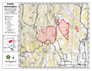
Improved accuracy in mapping, through field data collection, has reduced acreage for the incident to 15,580 acres with 46% containment.
Crews overnight continued work mopping up adjacent to the control line, gridding for hot spots or visible smoke. Tonight, night operations will transition to patrol status, as firefighters check for fire along the perimeter. This is indicative of the steady progress firefighters have made securing the fire.
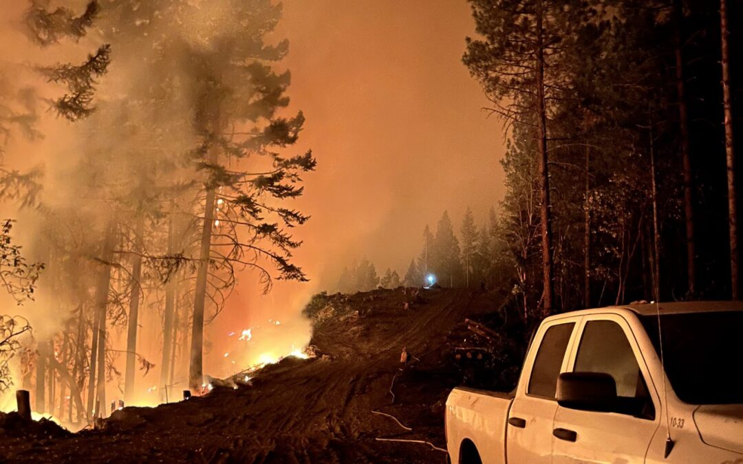
Today, operations will continue to focus on increasing the depth of mop-up along the fire perimeter. As firefighters work along the fireline extinguishing heat, they are systematically checking the area to ensure the fire remains within the current footprint. Hazard trees are being felled along the fire’s edge and adjacent to roadways to reduce risks to firefighters and the public.
Seven helicopters are assigned to the incident, available to support ground resources for aerial reconnaissance and water drops. These aircraft, along with other resources from the fire, are available to support local agencies with any new fire starts.
Temperatures in the upper 80’s, improved relative humidity and shifting winds are expected to create elevated fire conditions today. Receptive fuels along with the expected weather may result in rapid fire spread for any new ignitions.
Traffic is heavy along the roadways in the fire area as crews continue to patrol and mop-up the fire edge, use caution when traveling the area around the fire.
Oregon Department of Forestry Complex Incident Management Team 1 is transitioning command of the fire to a Florida Complex Incident Management Team on Monday at 6 a.m.
Shelter Update: As evacuation levels continue to decrease, the American Red Cross shelter at Eagle Point Middle School is no longer available for residents. The Red Cross will continue working with residents to support their transition as they return home. Residents needing sheltering assistance should contact Non-Emergency Dispatch at 541-776-7206.
Evacuations: There are evacuations in place in Jackson County, issued by the Sheriff’s Office and Emergency Management. Up-to-date evacuations are available here: https://readyjacksonco.com/Emergency/emergency-information-hub-east-evans-creek-road-fire
Find your evacuation zone here: https://tinyurl.com/EastEvansCreekFireEvacMap
Road/Land Closures: Traffic is closed to the public on East Evans Creek Road at Meadows Road. The BLM has issued a road closure for West Fork Evans Creek Road and Rock Creek Road. Please avoid the fire area to allow firefighters and heavy equipment to operate safely. Road closure information is available on https://tripcheck.com/
Smoke Impacts: Smoke from the East Evans Creek Fire may settle into valleys and other low-lying areas, reducing visibility and impacting air quality in nearby communities. Smoke conditions can change throughout the day as winds shift. Individuals sensitive to smoke should take appropriate precautions. For current air quality information and smoke forecasts, visit: https://fire.airnow.gov/.
Temporary Flight Restriction (TFR): A “TFR” is in place for the fire area daily (24 hours) until further notice. Complete information is available at https://tfr.faa.gov/tfr3/?page=detail_6_4915
Flying a drone near or around a wildfire is illegal, compromises the safety of both pilots and firefighters, and interferes with firefighting efforts.
Cause: The fire started on Friday, July 10th at 2:41 p.m. after a car crashed into a power pole, sparking dry vegetation in the area. The Jackson County Sheriff’s Office is currently investigating the cause of the crash.
MediaRelDailyUpdate_20260725_final
July 24, 2026
Minimal smoke visible from East Evans Creek Fire as crews continue to mop-up and strengthen control lines; evacuation levels downgraded
SAMS VALLEY, Ore. – Yesterday, firefighters continued to work deeper into the interior providing additional security to containment lines. Fire continues to creep and smolder in unburned fuels, however much of this activity is well interior of the fireline. As crews continue to mop-up, with a goal of 300 feet from the perimeter, they are looking for smoke and feeling for heat to extinguish.
Overnight, Unmanned Aircraft Systems and handheld infrared cameras were used to identify hot spots for day resources to address. Resources from the night shift are transitioning to day shift as work moves further into the interior, this provides for improved safety and better ability to detect areas of heat. Hazard trees are being felled to reduce overhead risks in areas where crews are working to mop-up the within the perimeter.
The fire remains at 15,705 acres, with containment increasing to 38% yesterday prompting the Jackson County Sheriff to downgrade evacuation levels because of continued progress. Crews are still working near residences, and fire traffic is heavy along the roadways, use caution when entering the fire area.
As containment increases some resources are shifting to repair work and back haul of equipment and firehose from the fireline. Bull dozers and excavators are being used to flatten berms created during line construction and eliminate areas where water can pool. They will also be installing water bars on control lines to divert run-off during rainy periods, mitigating soil erosion and impacts to water quality.
Aircraft remain available to support ground resources for aerial reconnaissance and water drops; tankers are available as needed.
Today will be a critical fire weather day with temperatures in the low 90’s, low relative humidity and breezy, westerly winds. This weather, combined with extremely dry fuels, has the potential for rapid fire spread. A local red flag warning is in effect from 2 p.m. until 7 p.m. for increased risk of new fire starts. Resources from the East Evans Creek Fire are available to support local agencies with these new starts.
Shelter Update: As evacuation levels continue to decrease, the American Red Cross shelter at Eagle Point Middle School will be closing today. The Red Cross will continue working with residents to support their transition as they return home. Residents needing sheltering assistance should contact Non-Emergency Dispatch at 541-776-7206.
Evacuations: There are evacuations in place in Jackson County, issued by the Sheriff’s Office and Emergency Management. Up-to-date evacuations are available here: https://readyjacksonco.com/Emergency/emergency-information-hub-east-evans-creek-road-fire
Find your evacuation zone here: https://tinyurl.com/EastEvansCreekFireEvacMap
Road/Land Closures: Traffic is closed to the public on East Evans Creek Road at Meadows Road. The BLM has issued a road closure for West Fork Evans Creek Road and Rock Creek Road. Please avoid the fire area to allow firefighters and heavy equipment to operate safely. Road closure information is available on https://tripcheck.com/
A closure order for BLM-administered lands near the East Evans Creek Fire is in place. Public entry, including hunting, hiking, and camping, is prohibited. More information about the closure, including a map, is available online at www.blm.gov/orwafire.
Smoke Impacts: Smoke from the East Evans Creek Fire may settle into valleys and other low-lying areas, reducing visibility and impacting air quality in nearby communities. Smoke conditions can change throughout the day as winds shift. Individuals sensitive to smoke should take appropriate precautions. For current air quality information and smoke forecasts, visit: https://fire.airnow.gov/.
Temporary Flight Restriction (TFR): A “TFR” is in place for the fire area daily (24 hours) until further notice. Complete information is available at https://tfr.faa.gov/tfr3/?page=detail_6_4915
Flying a drone near or around a wildfire is illegal, compromises the safety of both pilots and firefighters, and interferes with firefighting efforts.
Cause: The fire started on Friday, July 10th at 2:41 p.m. after a car crashed into a power pole, sparking dry vegetation in the area. The Jackson County Sheriff’s Office is currently investigating the cause of the crash.
MediaRelDailyUpdate_20260724_OR-711S-000039

July 23, 2026
East Evans Creek Fire remains within control lines despite heat and winds; containment increases to 33%
SAMS VALLEY, Ore. – Firefighters continue strengthening control lines across the East Evans Creek Fire while maintaining steady focus on mop-up into the interior of the fire. Many resources are shifting to day operations as containment increases and work moves further into the burned area. Overnight work included mopping up deeper into the interior and identifying hot spots with infrared cameras. Following multiple shifts of sustained effort, containment has reached 33%; the fire has remained in its footprint for multiple shifts at 15,705 acres with no overnight growth.
After several days of challenging weather, established control lines have been held, contributing to increased containment on the East Evans Creek Fire. Wildland firefighters continue strengthening protection around homes as part of ongoing suppression efforts, while local fire agencies remain available to respond to any changes in fire activity. As suppression efforts continue to reduce the threat to homes and other structures, Oregon State Fire Marshal (OSFM) resources are returning to their home agencies this morning and ODF CIMT remains in place. Resources that are no longer needed on the fire are being released to mobilize to other incidents around the state
Crews are using handheld infrared cameras and Unmanned Aircraft Systems (UAS) equipped with infrared technology to locate residual heat around the Board Mountain spot fire and along the main fire edge. This information continues to guide mop-up and support crew safety by identifying areas where the fire may be burning underground with no visible smoke. Firefighters are falling hazard trees to reduce overhead risks along the fireline and protect personnel.
Yesterday, thunderstorms with 30–35 mph wind gusts passed over the fire area. These increased winds fanned areas of heat, increasing visible smoke for firefighters to extinguish with water. Pockets of heat remain on the ground, and fuels are still receptive outside the fire line. Crews focused on these areas throughout the evening; similar winds are expected today.
Today, crews remain focused on protecting the community and firefighter safety by strengthening the established containment lines and further securing the perimeter, 63 miles of fireline have been constructed around the fire. Air assets continue to support the incident with aerial observation for ground crew intel and water drops to cool areas of heat. Interior parts of the fire are still smoldering with dry fuel.
Shelter Update: As evacuation levels continue to decrease, the American Red Cross shelter at Eagle Point Middle School will be closing today. The Red Cross will continue working with residents to support their transition as they return home. Residents needing sheltering assistance should contact Non-Emergency Dispatch at 541-776-7206.
Evacuations: There are evacuations in place in Jackson County, issued by the Sheriff’s Office and Emergency Management. Up-to-date evacuations are available here: https://readyjacksonco.com/Emergency/emergency-information-hub-east-evans-creek-road-fire
Find your evacuation zone here: https://tinyurl.com/EastEvansCreekFireEvacMap
Road/Land Closures: Traffic is closed to the public on East Evans Creek Road at Meadows Road. The BLM has issued a road closure for West Fork Evans Creek Road and Rock Creek Road. Please avoid the fire area to allow firefighters and heavy equipment to operate safely. Road closure information is available on https://tripcheck.com/
A closure order for BLM-administered lands near the East Evans Creek Fire is in place. Public entry, including hunting, hiking, and camping, is prohibited. More information about the closure, including a map, is available online at www.blm.gov/orwafire.
Smoke Impacts: Smoke from the East Evans Creek Fire may settle into valleys and other low-lying areas, reducing visibility and impacting air quality in nearby communities. Smoke conditions can change throughout the day as winds shift. Individuals sensitive to smoke should take appropriate precautions. For current air quality information and smoke forecasts, visit: https://fire.airnow.gov/.
Temporary Flight Restriction (TFR): A “TFR” is in place for the fire area daily (24 hours) until further notice. Complete information is available at https://tfr.faa.gov/tfr3/?page=detail_6_4915
Flying a drone near or around a wildfire is illegal, compromises the safety of both pilots and firefighters, and interferes with firefighting efforts.
Cause: The fire started on Friday, July 10th at 2:41 p.m. after a car crashed into a power pole, sparking dry vegetation in the area. The Jackson County Sheriff’s Office is currently investigating the cause of the crash.
MediaRelDailyUpdate_20260723_OR-711S-000039

July 22, 2026
Mop-up operations continue on the East Evans Creek Fire, resources shifting due to progress across incident
Firefighting resources assigned to the East Evans Creek Fire continued mop-up operations across the incident overnight, extinguishing hotspots and adding to overall containment. Following multiple shifts of this aggressive work, the fire is now 26% contained and is being held by resources at 15,705 acres with no new overnight growth reported by fire personnel.
Night shift crews made progress mopping up along the perimeter on the main fire and all spots. Firefighters used handheld infrared (IR) tools to locate residual heat around the Hull Mountain spot fire and along the main fire from the southern control line to the northeast corner. This information is now recorded for dayshift resources to extinguish today.
On the Board Mountain spot fire, mop-up continues along the entire perimeter, with a focus on the northeast portion; additional hazardous trees in this area need to be removed for firefighters to work more safely. In other areas, mop-up efforts are reaching 100-150 feet deep into the fire. On the Canyon Creek spot fire to the east, remaining hotspots are also being extinguished.
Thanks to the effectiveness of coordinated suppression efforts, the threat to structures has been significantly reduced on the East Evans Creek Fire. As a result, the Oregon State Fire Marshal (OSFM) has strategically reduced the number of structural task forces assigned to the incident.
Today, remaining structural resources will continue to support firefighting operations by strengthening mop-up around homes, conducting patrols, and maintaining a presence in neighborhoods surrounding the fire area. Firefighters will continue to monitor conditions closely and provide structure protection wherever it remains necessary.
A portion of wildland resources that have been working overnight on the incident are transitioning to day shift today, adding to firefighters on the line during peak weather times. This shift is due to the progress that has been made so far across the fire, and a strategic move ahead of incoming storms.
Weather could bring numerous challenges across the fire area today; a Red Flag Warning has been issued by the National Weather Service (NWS) for abundant lightning on dry fuels from 11 a.m. to 11 p.m. This designation covers the majority of Jackson County, including the fire. If thunderstorms materialize, winds are expected to be 20 miles per hour, with erratic gusts up to 45. These conditions will test the strength of established firelines; firefighters will continue to monitor for spot fires and will respond aggressively if fire threatens the line or crosses it.
Storms may bring heavy rain, and while this can be somewhat beneficial on the fire, it can also create hazardous conditions for firefighters to work and drive in. Flash flood warnings are not in effect, but resources will remain aware of these potential safety concerns. Excessive precipitation on a burned area can cause debris flows of water, mud, rocks and branches that can pose significant risk to firefighters on the line.
Lightning with minimal or no rain is a possibility today, which could ignite new fire starts across the area. Specific resources across the fire have been designated to rapidly assist the local ODF district in responding to new reports of fire if needed. Firefighters left on the line will continue building progress on mop-up operations. Aircraft will be available and used where needed on the fire throughout the day.
Shelter Update: As evacuation levels continue to decrease, the American Red Cross shelter at Eagle Point Middle School is no longer accepting new evacuees. The Red Cross will continue working with current shelter residents to support their transition. Residents needing sheltering assistance should contact Non-Emergency Dispatch at 541-776-7206.
Evacuations: There are evacuations in place in Jackson County, issued by the Sheriff’s Office and Emergency Management. Up-to-date evacuations are available here: https://readyjacksonco.com/Emergency/emergency-information-hub-east-evans-creek-road-fire
Find your evacuation zone here: https://tinyurl.com/EastEvansCreekFireEvacMap
Road/Land Closures: Traffic is closed to the public on East Evans Creek Road at Meadows Road. The BLM has issued a road closure for West Fork Evans Creek Road and Rock Creek Road. Please avoid the fire area to allow firefighters and heavy equipment to operate safely. Road closure information is available on https://tripcheck.com/
A closure order for BLM-administered lands near the East Evans Creek Fire is in place. Public entry, including hunting, hiking, and camping, is prohibited. More information about the closure, including a map, is available online at www.blm.gov/orwafire.
Smoke Impacts: Smoke from the East Evans Creek Fire may settle into valleys and other low-lying areas, reducing visibility and impacting air quality in nearby communities. Smoke conditions can change throughout the day as winds shift. Individuals sensitive to smoke should take appropriate precautions. For current air quality information and smoke forecasts, visit: https://fire.airnow.gov/.
Temporary Flight Restriction (TFR): A “TFR” is in place for the fire area daily (24 hours) until further notice. Complete information is available at https://tfr.faa.gov/tfr3/?page=detail_6_4915
Flying a drone near or around a wildfire is illegal, compromises the safety of both pilots and firefighters, and interferes with firefighting efforts.
Cause: The fire started on Friday, July 10th at 2:41 p.m. after a car crashed into a power pole, sparking dry vegetation in the area. The Jackson County Sheriff’s Office is currently investigating the cause of the crash.
SmokeOutlook_SW-Oregon-EastEvansCreek_20260722 MediaRelDailyUpdate_20260722_Draft
July 22, 2026
Steady Progress Leads to Increased Containment and Reduced Evacuations
SAMS VALLEY, Ore. – Firefighters on the East Evans Creek Fire increased containment to 26% today. Continued progress on the fire has allowed evacuation levels to be reduced in portions of Jackson County, while all evacuation notices have been lifted in Douglas County.
Today, aircraft supported operations along the southern and eastern flanks of the Board Mountain spot fire, helping cool active areas and slow fire spread. Ground crews continued mop-up operations to depths of up to 50 feet in some areas around the fire perimeter, working through pockets of heat and unburned vegetation. Due to steep terrain, aviation support is especially valuable.
Across the main fire, firefighters strengthened control lines increasing mop-up to an average of 50 feet, reducing potential for future fire spread. Structure protection resources reinforced completed remaining work around structures.
On the Canyon Creek spot fire, firefighters continue extinguishing scattered interior heat. Structure protection resources broadened mop-up operations around homes in the Long Branch area and maintained a presence in Shady Cove, Trail, and Dry Creek.
On the spot fire northwest of Hull Mountain, crews pushed farther into the interior, increasing mop-up to approximately 200 feet behind control lines. Structural engines also continued supporting suppression efforts in the steep terrain along Ramsey Canyon Road.
Tonight, firefighters will continue using handheld infrared (IR) technology to locate and extinguish hot spots near control lines while expanding mop-up operations. Overnight temperatures are expected to remain warmer throughout the evening, with a slight chance of thunderstorms. Hotter conditions and an increased potential for thunderstorms are forecast for tomorrow.
As conditions improve, containment increases and threats to structures reduce, some resources will be reassigned to support other incidents across Oregon. Resources will remain strategically positioned to maintain strong suppression capability, respond to changing conditions, and remain available for initial attack should any new fires start in the area.
This will be the final evening update on the East Evans Creek Fire unless conditions change. The morning fire update and twice daily operational briefing videos will continue to be provided.
Shelter Update: As evacuation levels continue to decrease, the American Red Cross shelter at Eagle Point Middle School is no longer accepting new evacuees. The Red Cross will continue working with current shelter residents to support their transition. Residents needing sheltering assistance should contact Non-Emergency Dispatch at 541-776-7206.
Evacuations: There are evacuations in place in Jackson County, issued by the Sheriff’s Office and Emergency Management. Up-to-date evacuations are available here: https://readyjacksonco.com/Emergency/emergency-information-hub-east-evans-creek-road-fire
Find your evacuation zone here: https://tinyurl.com/EastEvansCreekFireEvacMap
Road/Land Closures: Traffic is closed to the public on East Evans Creek Road at Meadows Road. The BLM has issued a road closure for West Fork Evans Creek Road and Rock Creek Road. Please avoid the fire area to allow firefighters and heavy equipment to operate safely. Road closure information is available on https://tripcheck.com/
A closure order for BLM-administered lands near the East Evans Creek Fire is in place. Public entry, including hunting, hiking, and camping, is prohibited. More information about the closure, including a map, is available online at www.blm.gov/orwafire.
Smoke Impacts: Smoke from the East Evans Creek Fire may settle into valleys and other low-lying areas, reducing visibility and impacting air quality in nearby communities. Smoke conditions can change throughout the day as winds shift. Individuals sensitive to smoke should take appropriate precautions. For current air quality information and smoke forecasts, visit: https://fire.airnow.gov/.
Temporary Flight Restriction (TFR): A “TFR” is in place for the fire area daily (24 hours) until further notice. Complete information is available at https://tfr.faa.gov/tfr3/?page=detail_6_4915
Flying a drone near or around a wildfire is illegal, compromises the safety of both pilots and firefighters, and interferes with firefighting efforts.
Cause: The fire started on Friday, July 10th at 2:41 p.m. after a car crashed into a power pole, sparking dry vegetation in the area. The Jackson County Sheriff’s Office is currently investigating the cause of the crash.
MediaRelDailyUpdate_PM_20260721_final (002)
July 21, 2026
Containment increases to 17% on the East Evans Creek Fire, mop-up continues
SAMS VALLEY, Ore. – Overnight, firefighters on the East Evans Creek Fire took advantage of cooler, more stable conditions to strengthen containment features, expand mop-up, and reinforce control lines. Night crews used infrared (IR) technology to identify and flag remaining hot spots, allowing firefighters to continue extinguishing heat during daylight operations. Although fire activity moderated over the past 24 hours, firefighters remain vigilant as triple-digit temperatures, lower relative humidity, a lifting inversion, and the potential for isolated thunderstorms today could increase fire activity. A Fire Weather Watch is in effect for Wednesday, with potential for thunderstorms and abundant lightning capable of producing new fire starts before hot, dry, and breezy conditions return later this week.
Across the fire, firefighters are steadily extending mop-up farther into the fire footprint. Mop-up is the process of locating, cooling, and extinguishing remaining heat to reduce the potential for rekindles and prevent fire from reaching or crossing established control lines. Structure protection crews continue supporting these efforts by focusing on mop-up around homes and reinforcing protection throughout nearby communities.
On the Board Mountain spot fire, firefighters will continue addressing remaining areas of unburned vegetation within the fire area to reduce available fuel and strengthen containment. Along the southern portion of the fire, crews will be assisted by felling personnel, who are removing fire-weakened and hazardous trees to improve firefighter safety and provide access for suppression operations. Due to steep, difficult terrain, helicopters and heavy equipment remain critical to suppression efforts. Structure protection crews continue supporting operations near homes in the Antioch, Jones Road, and Pomeroy areas.
On the Canyon Creek spot fire, firefighters continue extinguishing scattered pockets of heat where the fire burned unevenly, requiring methodical interior mop-up. Structure protection crews are extending mop-up in the Long Branch area outside Shady Cove, where fire previously encroached on homes, while proactive protection remains in place throughout the Shady Cove, Trail, and Dry Creek communities. In the Dry Creek and Shiloh areas, firefighters are advancing farther into the fire interior, conducting mop-up, removing hazardous trees, gridding for hidden heat, addressing heavy fuels, and using heavy equipment to improve access and support suppression operations.
On the spot fire northwest of Hull Mountain, firefighters continue pushing mop-up well into the fire’s interior, increasing the depth of extinguished fuels behind containment lines. In the Ramsey Canyon Road area, structure protection engines continue supplying water through high-pressure pump systems to firefighters extinguishing hot spots in steep, challenging terrain.
On the main fire, mop-up has progressed up to 150 feet into the fire footprint along the eastern edge and approximately 100 feet across much of the remaining perimeter. Around homes, structure protection crews have extended mop-up approximately 200 feet from structures. This progress reflects days of coordinated work to strengthen containment, increase the depth of extinguished fuels behind control lines, and reinforce protection around nearby communities.
The increased containment and reduced threats to structures have allowed several structure protection task forces and strike teams to return to their home agencies, enhancing statewide response capability while maintaining protection where it remains needed. In coordination with state and local partners, the incident continues strategically positioning both wildland and structure protection resources to support emerging initial attack and other priority incidents across southwest Oregon while maintaining the capability to respond to changing conditions on the East Evans Creek Fire.
Evacuations: There are evacuations in place in both Jackson and Douglas counties, issued by both counties’ Sheriff’s Offices and Emergency Management. Up-to-date evacuations are available here: https://readyjacksonco.com/Emergency/emergency-information-hub-east-evans-creek-road-fire
Find your evacuation zone here: https://tinyurl.com/EastEvansCreekFireEvacMap
Road/Land Closures: Traffic is closed to the public on East Evans Creek Road at Meadows Road. The BLM has issued a road closure for West Fork Evans Creek Road and Rock Creek Road. Please avoid the fire area to allow firefighters and heavy equipment to operate safely. Road closure information is available on https://tripcheck.com/
A closure order for BLM-administered lands near the East Evans Creek Fire is in place. Public entry, including hunting, hiking, and camping, is prohibited. More information about the closure, including a map, is available online at www.blm.gov/orwafire.
Smoke Impacts: Smoke from the East Evans Creek Fire may settle into valleys and other low-lying areas, reducing visibility and impacting air quality in nearby communities. Smoke conditions can change throughout the day as winds shift. Individuals sensitive to smoke should take appropriate precautions. For current air quality information and smoke forecasts, visit: https://fire.airnow.gov/.
Temporary Flight Restriction (TFR): A “TFR” is in place for the fire area daily (24 hours) until further notice. Complete information is available at https://tfr.faa.gov/tfr3/?page=detail_6_4915
Flying a drone near or around a wildfire is illegal, compromises the safety of both pilots and firefighters, and interferes with firefighting efforts.
Cause: The fire started on Friday, July 10th at 2:41 p.m. after a car crashed into a power pole, sparking dry vegetation in the area. The Jackson County Sheriff’s Office is currently investigating the cause of the crash.
MediaRelDailyUpdate_AM_20260721 pio_8x11_land_20260721_0412_EastEvansCreek_OR711S000039_0721Day

July 20, 2026
East Evans Creek Firefighters catch new spot fires and breaches of control line, continue to make progress despite hot, windy conditions
SAMS VALLEY, Ore. – Firefighters working on the East Evans Creek Fire continued to make progress across the incident on Monday, catching numerous new spot fires, building control line to stop new growth, and adding depth through mop-up operations. Cloud cover throughout the day helped to naturally decrease fire behavior in some areas, and resources took advantage of this opportunity to push forward on connecting and strengthening fireline. In other locations, wind factored into more active fire behavior, which resulted in several new spot fires, all of which were caught at small sizes. An overnight infrared (IR) flight will be ordered to map the fire and determine total new acreage. To date, firefighters have established more than 60 miles of control line on these fires and overall, containment has increased to 17% due to this work.
The Board Mountain spot fire remains the most active portion of the incident, and this morning, fire crossed a control line on the southeastern flank. Resources assigned to the southern portion were able to catch it and tighten up that area of control line today using heavy equipment and helicopters. Structural resources continued to support suppression efforts by providing a continuous water re-supply to helicopters at dip locations. Firefighters also focused their efforts on lining green islands of unburned vegetation within the fire’s perimeter to prevent them from potentially igniting later and threatening the line; in some of these areas, resources may conduct small-scale strategic firing operations tonight to eliminate the threat in a controlled manner. This work, if necessary, will aid in strengthening the fireline and ultimately contribute to greater containment in this area.
Due to elevated fire activity on the southern portion of the Board Mountain spot fire the past couple of days, the Jackson County Sheriff’s Office and Emergency Management issued precautionary Level 1 Be Ready evacuation notices for zones JAC-161 and JAC-204, just south of the fire late this morning. Additional evacuation information, including how to find your evacuation zone, is available below.
On the Canyon Creek spot fire, west of Shady Cove, small spot fires were located by aircraft, and firefighters were able to quickly respond and stop their growth. Resources have been working to extinguish these new spots and will continue to do so overnight. There are areas of unburned vegetation in the Canyon Creek spot fire as well and resources are working to address this potential threat to the line. If left unchecked, these fuels could ignite and create new spot fires.
On the spot fire northwest of Hull Mountain near Ramsey Canyon Road, firefighters are nearing 100-feet of mop-up into the interior of the fire on all sides. To assist firefighters with mop-up, structural engines are continuing to supply water up stretches of steep terrain. On the main body of the fire, resources also pushed forward on mopping up along the established perimeter, in some areas reaching 75-100 feet into the interior of the fire.
Wildland firefighters working overnight will continue the work that dayshift crews have done, strengthening line across the incident. Warmer evening conditions and lower relative humidity may mean slightly elevated fire activity, which will allow firefighters to more easily locate hotspots. Structural resources continue to maintain a presence in the Shady Cove, Trail, Long Branch and Dry Creek Communities, as well as the Antioch, Jones Roaad and Pomeroy areas. Mop-up work in these areas has been extensive, and as it continues, firefighters will be working further out from homes in these areas. Resources will once again be using handheld infrared (IR) tools to find and extinguish remaining heat to further secure these areas.
Hot temperatures and windy conditions remain in the extended forecast, along with the addition of potential thunderstorms over the fire area this week. Due to this threat, a fire weather watch has been issued by the National Weather Service (NWS) for abundant lightning on dry fuels from 11 a.m. to 11 p.m. on Wednesday. Instability in the atmosphere may contribute to storms, but precipitation is not a guarantee; dry lightning may be a possibility, which could ignite new fires in the area. A group of resources from the fire have been pre-identified to support the local district and respond to new fire starts if needed.
Evacuations: There are evacuations in place in both Jackson and Douglas counties, issued by both counties’ Sheriff’s Offices and Emergency Management. Up-to-date evacuations are available here: https://readyjacksonco.com/Emergency/emergency-information-hub-east-evans-creek-road-fire
Find your evacuation zone here: https://tinyurl.com/EastEvansCreekFireEvacMap
Road/Land Closures: Traffic is closed to the public on East Evans Creek Road at Meadows Road. The BLM has issued a road closure for West Fork Evans Creek Road and Rock Creek Road. Please avoid the fire area to allow firefighters and heavy equipment to operate safely. Road closure information is available on https://tripcheck.com/
A closure order for BLM-administered lands near the East Evans Creek Fire is in place. Public entry, including hunting, hiking, and camping, is prohibited. More information about the closure, including a map, is available online at www.blm.gov/orwafire.
Smoke Impacts: Smoke from the East Evans Creek Fire may settle into valleys and other low-lying areas, reducing visibility and impacting air quality in nearby communities. Smoke conditions can change throughout the day as winds shift. Individuals sensitive to smoke should take appropriate precautions. For current air quality information and smoke forecasts, visit: https://fire.airnow.gov/.
Temporary Flight Restriction (TFR): A “TFR” is in place for the fire area daily (24 hours) until further notice. Complete information is available at https://tfr.faa.gov/tfr3/?page=detail_6_4915
Flying a drone near or around a wildfire is illegal, compromises the safety of both pilots and firefighters, and interferes with firefighting efforts.
Cause: The fire started on Friday, July 10th at 2:41 p.m. after a car crashed into a power pole, sparking dry vegetation in the area. The Jackson County Sheriff’s Office is currently investigating the cause of the crash.
MediaRelDailyUpdate_AM_20260720
July 20, 2026
Firefighters complete line around active portion of Board Mountain spot fire, progress continues today
SAMS VALLEY, Ore. – Overnight, firefighters on the East Evans Creek Fire continued to make steady progress across the incident. Crews pushed mop-up operations deeper into the fire’s interior and strengthened control lines. Extensive structure preparation and protection measures have been completed around threatened communities.
Resources on the Board Mountain spot fire strengthened existing control lines, including the southwestern edge where the fire crossed the fireline late yesterday. Overnight, crews focused on the southern portion of the fire south of Boswell Mountain to reinforce the perimeter and limit additional spread. Operations today will continue to surge on the southern portion of the Board Mountain spot fire, focusing on improving the line, mop-up and felling trees to reduce overhead hazards. Structural resources remain positioned near homes in the Antioch, Jones Road, and Pomeroy areas, as well as in the Shady Cove, Trail, Long Branch, and Dry Creek communities, as part of a proactive structure protection strategy while supporting wildland operations. Structural resources bolstered suppression efforts and patrolled areas near homes, checking for hot spots.
Across the main fire, control lines held, and firefighters remained vigilant as dry vegetation and persistent heat continues to support elevated spotting potential. Crews also held the Canyon Creek spot fire within its existing footprint overnight and continued working adjacent to the fireline to secure the perimeter on the spot fire northwest of Hull Mountain. Firefighters will continue extending hose lays to support deeper mop-up operations, while structural crews maintain a presence in the Ramsey Canyon Road area and continue providing high-capacity pump support to increase water delivery for wildland operations. Crews today will again be available for repositioning to bolster other areas of the fire or to support initial attack with local agencies. Structure protection resources remain in place in the Shady Cove, Trail, Canyon Road, Dry Creek, and other nearby areas holding the lines.
An incident meteorologist is on scene monitoring conditions including cloud cover, which can delay the lift of the inversion. Although morning temperatures are cooler and isolated showers have been observed, winds are expected to pick up again in the afternoon, and temperatures may reach the mid- to high-90s. Dry fuels, steep terrain, and shifting winds remain factors that could challenge containment efforts later in the day, and spotting potential continues to be elevated. With strengthened lines, overnight cooling, and coordinated support across the incident, firefighters enter the day positioned to build on yesterday’s progress while remaining alert to potentially increased fire activity as conditions shift.
Aircraft today will work with ground resources to address hot spots and support firefighters as they work to tighten the southeast side of the Board Mountain spot fire, where crews and initial dozer line stopped forward movement overnight. Structural tenders will continue supporting water delivery to helicopter dip sites, as needed, to sustain aerial suppression operations.
Evacuations: There are evacuations in place in both Jackson and Douglas counties, issued by both counties’ Sheriff’s Offices and Emergency Management. Up-to-date evacuations are available here: https://readyjacksonco.com/Emergency/emergency-information-hub-east-evans-creek-road-fire
Find your evacuation zone here: https://tinyurl.com/EastEvansCreekFireEvacMap
Road/Land Closures: Traffic is closed to the public on East Evans Creek Road at Meadows Road. The BLM has issued a road closure for West Fork Evans Creek Road and Rock Creek Road. Please avoid the fire area to allow firefighters and heavy equipment to operate safely. Road closure information is available on https://tripcheck.com/
A closure order for BLM-administered lands near the East Evans Creek Fire is in place. Public entry, including hunting, hiking, and camping, is prohibited. More information about the closure, including a map, is available online at www.blm.gov/orwafire.
Smoke Impacts: Smoke from the East Evans Creek Fire may settle into valleys and other low-lying areas, reducing visibility and impacting air quality in nearby communities. Smoke conditions can change throughout the day as winds shift. Individuals sensitive to smoke should take appropriate precautions. For current air quality information and smoke forecasts, visit: https://fire.airnow.gov/.
Temporary Flight Restriction (TFR): A “TFR” is in place for the fire area daily (24 hours) until further notice. Complete information is available at https://tfr.faa.gov/tfr3/?page=detail_6_4915
Flying a drone near or around a wildfire is illegal, compromises the safety of both pilots and firefighters, and interferes with firefighting efforts.
Cause: The fire started on Friday, July 10th at 2:41 p.m. after a car crashed into a power pole, sparking dry vegetation in the area. The Jackson County Sheriff’s Office is currently investigating the cause of the crash.
MediaRelDailyUpdate_AM_20260720
July 19, 2026
SAMS VALLEY, Ore. – Firefighters continued making steady progress across the East Evans Creek Fire today, ahead of another afternoon of critical fire weather. The strategic relocation of helicopters to an alternate base outside the morning inversion proved successful, allowing aircraft to begin flying earlier in the day and maximizing support for firefighters on the ground. Structural tenders supported suppression efforts by supplying water to dip sites, helping helicopters maintain a steady pace of water-dropping operations throughout the day.
On the Board Mountain spot fire, where a portion of the fire crossed established control lines yesterday, firefighters continued strengthening and connecting lines around the expanded fire area. Although crews were having success securing the perimeter, this afternoon, fire activity increased on the southern and eastern edges, where the fire again crossed control lines. The eastern slop over has been controlled, and firefighters are actively engaged in the area southwest of Boswell Mountain. A large airtanker with retardant has been ordered to support suppression efforts. Structural resources remain positioned near homes in the Antioch, Jones Road, and Pomeroy areas to provide structure protection while supporting wildland suppression operations.
On the Canyon Creek spot fire, firefighters quickly contained a roughly half-acre slop over after a burning tree fell across the control line, carrying embers into unburned vegetation west of the fire edge. Resources, including helicopters with water buckets, rapidly engaged the spot before it could spread further and are continuing mop-up operations. Structural resources remain assigned throughout the Shady Cove, Trail, Long Branch, and Dry Creek areas as part of a proactive structure protection plan.
Although hot, dry conditions and decreasing relative humidity contributed to increased fire activity on the Board Mountain and Canyon Creek spot fires this afternoon, activity has been limited across the main fire and the spot northwest of Hull Mountain, where firefighters installed additional hose lays to extend mop-up operations farther into the fire area. Structural preparation has been completed in the Ramsey Canyon Road area, and crews are continuing to provide high-capacity pump support to increase water delivery for wildland operations.
Tonight, across the main fire, firefighters will continue pushing mop-up farther into the fire footprint, increasing the depth of extinguished fuels behind established control lines to reduce the potential for heat reaching containment features. Resources assigned to more stable portions of the incident are available to quickly reinforce areas experiencing increased fire activity, allowing operations to remain flexible as conditions evolve.
Spotting potential remains elevated as exceptionally dry vegetation, heavy fuel loading, steep terrain, and persistent heat continue to support rapid fire spread. While completed and strengthened control lines have reduced risk in many areas, critical fire weather remains the primary operational concern. Hot temperatures, shifting winds, and a low potential for dry thunderstorms could challenge suppression efforts, with any increase in wind capable of quickly increasing fire activity. Incident meteorologists continue to monitor changing weather patterns, including a potential increase in monsoonal moisture early next week, before another period of hot, dry, and breezy conditions returns later in the week.
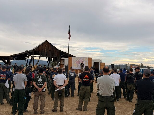
This afternoon’s community meeting was well attended both in person and online. Firefighters appreciate the continued engagement and support from the community as operations progress. Providing timely, transparent information remains a priority as crews continue working around the clock to extinguish the fire, strengthen control lines, protect homes, and respond wherever conditions require.
Tonight, resources from the incident are also supporting initial attack efforts on a new start in the ODF Southwest Oregon District. This coordinated effort helps ensure firefighters and equipment are available to respond quickly to new fire starts while continuing ongoing suppression operations.
Evacuations: There are evacuations in place in both Jackson and Douglas counties, issued by both counties’ Sheriff’s Offices and Emergency Management. Up-to-date evacuations are available here: https://readyjacksonco.com/Emergency/emergency-information-hub-east-evans-creek-road-fire
Find your evacuation zone here: https://tinyurl.com/EastEvansCreekFireEvacMap
Road/Land Closures: The Tiller-Trail Highway is closed at the county border in Jackson County to Highway 62. Traffic is closed to the public on East Evans Creek Road at Meadows Road. The BLM has issued a road closure for West Fork Evans Creek Road and Rock Creek Road. Please avoid the fire area to allow firefighters and heavy equipment to operate safely. Road closure information is available on https://tripcheck.com/
A closure order for BLM-administered lands near the East Evans Creek Fire is in place. Public entry, including hunting, hiking, and camping, is prohibited. More information about the closure, including a map, is available online at www.blm.gov/orwafire.
Smoke Impacts: Smoke from the East Evans Creek Fire may settle into valleys and other low-lying areas, reducing visibility and impacting air quality in nearby communities. Smoke conditions can change throughout the day as winds shift. Individuals sensitive to smoke should take appropriate precautions. For current air quality information and smoke forecasts, visit: https://fire.airnow.gov/.
Temporary Flight Restriction (TFR): A “TFR” is in place for the fire area daily (24 hours) until further notice. Complete information is available at https://tfr.faa.gov/tfr3/?page=detail_6_4915
Flying a drone near or around a wildfire is illegal, compromises the safety of both pilots and firefighters, and interferes with firefighting efforts.
Cause: The fire started on Friday, July 10th at 2:41 p.m. after a car crashed into a power pole, sparking dry vegetation in the area. The Jackson County Sheriff’s Office is currently investigating the cause of the crash.
MediaRelDailyUpdate_PM_20260719_final
July 19, 2026
Winds and Dry Conditions Continue to Challenge Containment on East Evans Creek Fire
There is a community meeting planned for Sunday, July 19, 2026, at 2:00 p.m. to provide a brief operational update on the fire:
In Person: Shady Cove School Gym, 100 Cleveland St, Shady Cove, OR 97539
Stream online via: Facebook.com/ODFSouthwest
As of 7:15 PM last night the Jackson County Sheriff’s Office has implemented upgraded evacuation levels in affected areas.
SAMS VALLEY, Ore. –Firefighters on the East Evans Creek Fire worked overnight to hold and improve control lines, taking advantage of improved humidity recoveries to moderate fire behavior and secure areas impacted by yesterday evening’s wind-driven activity.
On the Board Mountain spot fire, crews continued engaging areas where fire crossed control lines on the southwestern edge south of Boswell Mountain. Firefighters made progress working to tie the spot fire into existing lines, though steep terrain and limited access continue to challenge suppression efforts.
Today, wildland and structural firefighting resources are being strategically repositioned to the southern edge of the Board Mountain spot fire to rapidly engage the area where fire crossed established control lines. This focused effort is intended to take advantage of current conditions, strengthen suppression actions, and improve containment in that area. Fire behavior is expected to challenge firefighters as conditions change this afternoon.
The main fire and the spot fire northwest of Hull Mountain remain in hold and mop-up status. Crews are strengthening existing lines, removing hazard trees, and using handheld infrared technology to locate and extinguish remaining heat.
On the Canyon Creek spot fire, firefighters maintained containment while continuing to deepen mop-up operations.
As structural crews continue detailed assessments of areas impacted by the fire and gain access to additional locations within the fire footprint, additional damage has been identified, including one primary residence that had been vacant for an extended period and five outbuilding structures with fire-related damage. Assessments remain ongoing as crews continue to evaluate impacted areas.
Structure protection efforts expanded into the Antioch, Pomeroy, and Jones Road areas as forecasted winds and dry conditions increased the potential for fire to impact homes. Crews conducted structural preparation and improved water availability, building on earlier planning efforts to ensure a rapid and effective response as conditions evolve. Today, structural resources will continue reinforcing these measures while working in coordination with wildland firefighters.
Additional crews and equipment are also positioned alongside local resources to strengthen initial attack capability, ensuring a rapid response to any new fire starts and increased fire behavior under today’s forecasted hot, dry, and windy conditions.
Aircraft will support ground operations as conditions allow. To improve early-day aviation access, five of the helicopters have been relocated out of the inversion zone, allowing the aircraft to begin flying earlier in the day as visibility improves.
Due to increased fire activity across the state, an infrared flight was not completed overnight. As a result, updated acreage and maps will not be available today.
Evacuations: There are evacuations in place in both Jackson and Douglas counties, issued by both counties’ Sheriff’s Offices and Emergency Management. Up-to-date evacuations are available here: https://readyjacksonco.com/Emergency/emergency-information-hub-east-evans-creek-road-fire
Find your evacuation zone here: https://tinyurl.com/EastEvansCreekFireEvacMap
Road/Land Closures: The Tiller-Trail Highway is closed at the county border in Jackson County to Highway 62. Traffic is closed to the public on East Evans Creek Road at Meadows Road. The BLM has issued a road closure for West Fork Evans Creek Road and Rock Creek Road. Please avoid the fire area to allow firefighters and heavy equipment to operate safely. Road closure information is available on https://tripcheck.com/
A closure order for BLM-administered lands near the East Evans Creek Fire is in place. Public entry, including hunting, hiking, and camping, is prohibited. More information about the closure, including a map, is available online at www.blm.gov/orwafire.
Smoke Impacts: Smoke from the East Evans Creek Fire may settle into valleys and other low-lying areas, reducing visibility and impacting air quality in nearby communities. Smoke conditions can change throughout the day as winds shift. Individuals sensitive to smoke should take appropriate precautions. For current air quality information and smoke forecasts, visit: https://fire.airnow.gov/.
Temporary Flight Restriction (TFR): A “TFR” is in place for the fire area daily (24 hours) until further notice. Complete information is available at https://tfr.faa.gov/tfr3/?page=detail_6_4915
Flying a drone near or around a wildfire is illegal and compromises the safety of both pilots and firefighters and interferes with firefighting efforts.
Cause: The fire started on Friday, July 10th at 2:41 p.m. after a car crashed into a power pole, sparking dry vegetation in the area. The Jackson County Sheriff’s Office is currently investigating the cause of the crash.
MediaRelDailyUpdate_AM_20260719_finalpio_8x11_land_20260719_0816_EastEvansCreek_OR711S000039_0719Day

July 18, 2026
There is a community meeting planned for Sunday, July 19, 2026, at 2:00 p.m. to provide a brief operational update on the fire:
In Person: Shady Cove School Gym, 100 Cleveland St, Shady Cove, OR 97539
Stream online via: Facebook.com/ODFSouthwest
Increased temperatures and gusty winds push Board Mountain spot fire southwest across control lines
Upgraded evacuation levels have been put in place by the Jackson County Sherrif’s Office
SAMS VALLEY, Ore. – Today, crews working on the East Evans Creek Fire faced increased fire behavior due to warmer temperatures, lower humidity, and gusty winds. These conditions tested firelines in many places, but firefighters quickly caught many of the spot fires and slopovers. Firefighters anticipated these changing conditions and placed additional resources in these challenging areas.
On the southwestern edge of the Board Mountain spot fire, the fire pushed across containment lines and spotted into adjacent wildland fuels south of Boswell Mountain, this spot fire is estimated to be 150 acres. Air tankers were immediately ordered, and additional helicopters were launched to support suppression operations and reduce fire behavior, allowing firefighters to construct direct fireline.
Along the northern edge the Board Mountain, spot fires also challenged firefighters, pushing against the line in several places. Firefighters were able to catch areas where fire moved across the line, establishing new fireline and rapidly cooling these areas. Significant areas of unburned fuel and vegetation in this area have made it difficult to hold the fire within the line. Tonight, firefighters may use tactical firing operations to remove this fuel adjacent to the fireline in a controlled operation to secure the fire in this area.
Firefighters continued extensive mop-up on the Canyon Creek spot fire, furthest to the east. This fire held within control lines as firefighters continued to work interior of the fire perimeter reducing heat and eliminating hot spots. Structural resources continued working within the Shady Cove, Trail, and Ramsey Canyon Road communities to proactively triage homes and reinforce structural protection plans.
Along the perimeter of the spot fire northwest of Hull Mountain, crews worked to connect portions of fireline in steep, rugged terrain. Line construction has challenged firefighters, but they continue making progress to limit fire growth. Structural preparation in this area is nearly complete, and coordinated efforts have worked to increase water availability to strengthen suppression efforts.
On the main fire, work remains focused on mop-up, further strengthening of the fireline, and felling snags to reduce overhead hazards. Firefighters are using handheld infrared cameras near firelines and homes to help detect areas of heat buried underground. Once identified, crews expose and extinguish these areas, using water and tools to prevent rekindles.
This morning’s inversion limited aircraft use due to poor visibility. However, this afternoon, aircraft were used to cool areas of the fire, allowing firefighters to construct fireline directly adjacent to the fire and reduce potential growth. A similar inversion is expected tomorrow morning.
Hotter, drier weather is expected with increased instability and winds over the next several days, with the potential for thunderstorms. This expected weather, along with dry fuels receptive to ignition from embers or lightning, is a concern for firefighters.
Evacuations: There are evacuations in place in both Jackson and Douglas counties, issued by both counties’ Sheriff’s Offices and Emergency Management. Up-to-date evacuations are available here: https://readyjacksonco.com/Emergency/emergency-information-hub-east-evans-creek-road-fire
Find your evacuation zone here: https://tinyurl.com/EastEvansCreekFireEvacMap
Road/Land Closures: The Tiller-Trail Highway is closed at the county border in Jackson County to Highway 62. Traffic is closed to the public on East Evans Creek Road at Meadows Road. The BLM has issued a road closure for West Fork Evans Creek Road and Rock Creek Road. Please avoid the fire area to allow firefighters and heavy equipment to operate safely. Road closure information is available on https://tripcheck.com/
A closure order for BLM-administered lands near the East Evans Creek Fire is in place. Public entry, including hunting, hiking, and camping, is prohibited. More information about the closure, including a map, is available online at www.blm.gov/orwafire.
Smoke Impacts: Smoke from the East Evans Creek Fire may settle into valleys and other low-lying areas, reducing visibility and impacting air quality in nearby communities. Smoke conditions can change throughout the day as winds shift. Individuals sensitive to smoke should take appropriate precautions. For current air quality information and smoke forecasts, visit: https://fire.airnow.gov/.
Temporary Flight Restriction (TFR): A “TFR” is in place for the fire area daily (24 hours) until further notice. Complete information is available at https://tfr.faa.gov/tfr3/?page=detail_6_4915
Flying a drone near or around a wildfire is illegal and compromises the safety of both pilots and firefighters and interferes with firefighting efforts.
Cause: The fire started on Friday, July 10th at 2:41 p.m. after a car crashed into a power pole, sparking dry vegetation in the area. The Jackson County Sheriff’s Office is currently investigating the cause of the crash.
MediaRelDailyUpdate_AM_20260718
July 18, 2026
There is a community meeting planned for Sunday, July 19, 2026, at 2:00 p.m. to provide a brief operational update on the fire:
In Person: Shady Cove School Gym, 100 Cleveland St, Shady Cove, OR 97539
Stream online via: Facebook.com/ODFSouthwest
All lines holding on East Evans Creek Fire, resources prepare for critical fire weather to return
SAMS VALLEY, Ore. – Overnight, firefighters on the East Evans Creek Fire pushed forward on progress, holding and strengthening existing line around the fire and spot fires, and constructing new line where needed. This morning, the fire is 13,999 acres and containment has increased to 8%.
On the main fire, mop-up operations continued Friday night across the southern, western and northern flanks. All control lines are holding well and firefighters in these areas worked to bolster lines and add depth. To the southwest, wildland firefighters held and strengthened lines on the spot fire northwest of Hull Mountain, with no new overnight growth. Today, firefighters will focus on the northern flank, building and improving lines, and removing hazard trees to eliminate threats to resources working in the area.
Lines on the north, east and west sides of the Board Mountain spot fire are holding, and firefighters continued to connect hose to allow for more water flow across the fire. To date, 50 miles of hose lay has been installed across the incident. Additional work is needed in some areas on the southern tip where bulldozers have been unable to access. Today, hand crews will get into these areas with a goal of completing these portions of fireline.
On the Canyon Creek spot fire closest to Shady Cove, lines held well overnight and firefighters worked on mop-up operations and improving line where needed. To the east, resources are building alternate lines as a precaution between the fires and Shady Cove, Trail and surrounding communities.
Structural firefighters continued overnight mop-up operations around threatened structures, using thermal imaging cameras (TICs) to detect and extinguish hidden pockets of heat that could rekindle during the day. In areas where heat has been significantly reduced, structural crews are transitioning from active mop-up to patrol status while continuing to monitor conditions and respond quickly to any new fire activity.
The past 36 hours provided a break in high temperatures and lower relative humidity, and resources took advantage of those opportunities to the fullest; today, hotter, drier weather will return, and firefighters are prepared for the potential of increased fire activity once again. Temperatures will peak in the mid-90s, relative humidity will drop to near 20% and winds are expected to pick up in the afternoon, gusting up to 25 miles per hour.
With these conditions in the forecast, resources will be watching for spot fires and areas where the fire could threaten existing lines. Along with these conditions, the inversion is expected to lift and smoke will likely clear. Clear air will allow aircraft to safely fly and assist firefighters on the ground with intel and firefighting efforts.
Evacuations: There are evacuations in place in both Jackson and Douglas counties, issued by both counties’ Sheriff’s Offices and Emergency Management. Up-to-date evacuations are available here: https://readyjacksonco.com/Emergency/emergency-information-hub-east-evans-creek-road-fire
Find your evacuation zone here: https://tinyurl.com/EastEvansCreekFireEvacMap
Road/Land Closures: The Tiller-Trail Highway is closed at the county border in Jackson County to Highway 62. Traffic is closed to the public on East Evans Creek Road at Meadows Road. The BLM has issued a road closure for West Fork Evans Creek Road and Rock Creek Road. Please avoid the fire area to allow firefighters and heavy equipment to operate safely. Road closure information is available on https://tripcheck.com/
A closure order for BLM-administered lands near the East Evans Creek Fire is in place. Public entry, including hunting, hiking, and camping, is prohibited. More information about the closure, including a map, is available online at www.blm.gov/orwafire.
Smoke Impacts: Smoke from the East Evans Creek Fire may settle into valleys and other low-lying areas, reducing visibility and impacting air quality in nearby communities. Smoke conditions can change throughout the day as winds shift. Individuals sensitive to smoke should take appropriate precautions. For current air quality information and smoke forecasts, visit: https://fire.airnow.gov/.
Temporary Flight Restriction (TFR): A “TFR” is in place for the fire area daily (24 hours) until further notice. Complete information is available at https://tfr.faa.gov/tfr3/?page=detail_6_4915
Flying a drone near or around a wildfire is illegal and compromises the safety of both pilots and firefighters and interferes with firefighting efforts.
Cause: The fire started on Friday, July 10th at 2:41 p.m. after a car crashed into a power pole, sparking dry vegetation in the area. The Jackson County Sheriff’s Office is currently investigating the cause of the crash.
MediaRelDailyUpdate_AM_20260718 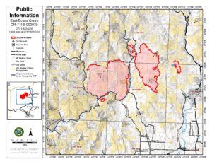
July 17, 2026
There is a community meeting planned for Sunday, July 19, 2026, at 2:00 p.m. to provide a brief operational update on the fire:
In Person: Shady Cove School Gym, 100 Cleveland St, Shady Cove, OR 97539
Stream online via: Facebook.com/ODFSouthwest
Firefighters Prepare for Critical Weather on East Evans Creek Fire
SAMS VALLEY, Ore. – Firefighters made steady progress across the main body of the East Evans Creek Fire today, continuing to strengthen containment lines, support structure protection, and prepare for hotter, drier weather expected through the weekend. Aircraft use was limited for much of the day as a persistent inversion delayed flying conditions until late afternoon.
The Board Mountain spot fire continues to present operational challenges. Steep terrain and gusty afternoon winds along the southern portion of the fire have required coordinated suppression efforts from ground crews, heavy equipment, and aircraft when conditions allow. Although the fire challenged established lines on the southern edge, it was quickly attacked by firefighters already in position. Crews remain actively engaged in a firefight this evening as strong northwest winds have increased fire activity. Aircraft, dozers, and hand crews worked together to slow fire spread and reinforce suppression efforts.
On the spot fire located northwest of Hull Mountain, firefighters have made progress on fireline, despite challenging terrain. Crews are working to cool and hold the spot fire within its current footprint. High-capacity pumping capabilities provided by structural engines were necessary to support extensive hose lays.
On the Canyon Creek spot fire, firefighters have completed line construction around the perimeter and are using plumbed hose line to support suppression efforts where possible. While line has been established around the entire spot fire, the eastern edge remains active, and significant work continues to strengthen, secure, and hold those lines.
Firefighters in the western and northwestern portions of the main fire have adjusted sections of line to utilize existing road systems and are conducting tactical firing operations to strategically remove unburned fuels adjacent to firelines, where necessary. Firing operations strengthen fireline by methodically reducing vegetation that could otherwise ignite and contribute to unpredictable fire spread.
On the northern perimeter of the main fire, lines have remained secure through several operational periods with no significant control issues. Along the eastern and southern edge of the main fire, crews are continuing mop-up operations along the fire edge, working up to 25 feet inside the fire perimeter to locate and cool hidden hot spots.
Structural resources remain engaged throughout the fire area. Around homes previously encroached on by fire on the eastern and southern edge, firefighters continue to focus on locating and extinguishing lingering heat near structures. Crews are expanding structure preparation, improving defensible space, completing additional structure assessments, and refining structure protection plans, should fire conditions change.
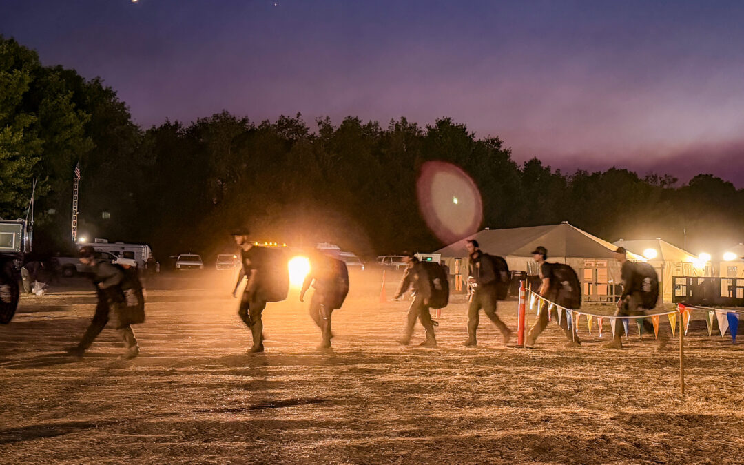
Tonight, more than 500 personnel—including wildland firefighters, structural protection resources, and heavy equipment operators—will continue working through the night on the fire. Overnight operations will focus on strengthening and reinforcing containment lines, improving access where needed, and positioning personnel and equipment to respond to flare-ups.
Fire activity across Oregon continues to challenge firefighting resources statewide. Through strong interagency coordination, personnel, equipment, and aircraft are strategically shared to support communities and provide the most effective response possible. This evening, a helicopter assigned to the incident provided initial attack support to a nearby fire, highlighting the collaborative effort underway across Oregon’s firefighting community. As fire conditions remain dynamic, agencies continue to work together to prioritize resources, support one another, and maintain the strongest possible response across the state.
Evacuations: There are evacuations in place in both Jackson and Douglas counties, issued by both counties’ Sheriff’s Offices and Emergency Management. Up-to-date evacuations are available here: https://readyjacksonco.com/Emergency/emergency-information-hub-east-evans-creek-road-fire
Find your evacuation zone here: https://tinyurl.com/EastEvansCreekFireEvacMap
Road/Land Closures: The Tiller-Trail Highway is closed at the county border in Jackson County to Highway 62. Traffic is closed to the public on East Evans Creek Road at Meadows Road. The BLM has issued a road closure for West Fork Evans Creek Road and Rock Creek Road. Please avoid the fire area to allow firefighters and heavy equipment to operate safely. Road closure information is available on https://tripcheck.com/
A closure order for BLM-administered lands near the East Evans Creek Fire is in place. Public entry, including hunting, hiking, and camping, is prohibited. More information about the closure, including a map, is available online at www.blm.gov/orwafire.
Smoke Impacts: Smoke from the East Evans Creek Fire may settle into valleys and other low-lying areas, reducing visibility and impacting air quality in nearby communities. Smoke conditions can change throughout the day as winds shift. Individuals sensitive to smoke should take appropriate precautions. For current air quality information and smoke forecasts, visit: https://fire.airnow.gov/.
Temporary Flight Restriction (TFR): A “TFR” is in place for the fire area daily (24 hours) until further notice. Complete information is available at https://tfr.faa.gov/tfr3/?page=detail_6_4915
Flying a drone near or around a wildfire is illegal and compromises the safety of both pilots and firefighters and interferes with firefighting efforts.
Cause: The fire started on Friday, July 10th at 2:41 p.m. after a car crashed into a power pole, sparking dry vegetation in the area. The Jackson County Sheriff’s Office is currently investigating the cause of the crash.
MediaRelDailyUpdate_PM_20260717
July 17, 2026
Firefighters on East Evans Creek Fire line Canyon Creek spot fire
SAMS VALLEY, Ore. (July 17, 2026) – Overnight, firefighters were able to complete line construction on the Canyon Creek spot fire and establish firehose to the perimeter. Day shift crews will continue securing and strengthening the fireline today, using water to reduce heat near the fire’s edge. The Ramsey Creek spot fire remained within control lines constructed during day shift; firefighters worked overnight and will continue today to strengthen fireline and work to hold the fire in its current footprint.
Firefighters working on the Board Mountain spot fire were able to use natural fire progression and small-scale tactical burning to remove unburned fuel between the fire’s edge and the fireline on the northern perimeter as fire moved slowly up to the constructed indirect fireline. Today, firefighters will work to strengthen this fireline. The southern area of this fire continues to have active fire behavior southwest of Boswell Mountain. Additional resources are bolstering efforts in this area, working to construct and extend the direct fireline and address spot fires.
Structural resources maintained a presence throughout the East Evans Creek Fire area, including Long Branch Road, Shady Cove, Trail, East Evans Creek Road, West Fork Evans Creek Road, and the Hull Mountain area, continuing structure preparation, improved defensible space, completed structure assessments in additional neighborhoods, and extinguished lingering heat around threatened homes.
Mop-up on the southern edge of the main fire along East Evans Creek Road continues, as firefighters work to ensure the areas adjacent to homes and the fire perimeter have no residual heat. Today, firefighters will continue to work along the West Fork Evans Creek Road securing the fire’s edge and moving to the north to connect portions of fireline along the western edge of the fire. Fuels and vegetation in the area north of Spignet Butte have been receptive to embers and firefighters have been pushed to keep the fire from crossing the existing fireline. Efforts continue to focus on increasing fireline width to reduce potential ember wash across it, igniting fuels outside the line further securing the northern perimeter.
Structural engines supported wildland suppression efforts by operating high-pressure pump systems, water tenders, and portable water delivery equipment to firefighters working in steep terrain. A water supply site, supported by local agencies, has been established at the Dodge Bridge Boat Ramp to provide a reliable source of water for ongoing firefighting operations. To safely support these operations, the boat ramp is temporarily closed to public access.
The fire remains 5% contained and is currently 13,090 acres total. Spot fires from embers carried by afternoon winds, combined with critically dry fuels, continue to challenge firefighters. Firefighters are covering nearly 60 miles of fire perimeter searching for areas of heat and opportunities to halt fire progression. Cooler temperatures overnight supported firefighting operations, reducing fire behavior and allowing direct line construction across much of the fire. An inversion over much of the fire will be slow to lift today, moderating fire behavior this morning, however fuels remain critically dry and receptive to ember ignition. Today, a warming, drying trend will return to the area, along with gusty northwest winds.
Fourteen helicopters are assigned to the fire to support ground operations by cooling and slowing fire progression with water drops and providing information on fire movement and spotting. Air tankers are available by request. Today’s inversion may limit aerial operations due to limited visibility.
Road/Land Closures: The Tiller-Trail Highway is closed at the county border in Jackson County to Highway 62. Traffic is closed to the public on East Evans Creek Road at Meadows Road. The BLM has issued a road closure for West Fork Evans Creek Road and Rock Creek Road. Please avoid the fire area to allow firefighters and heavy equipment to operate safely. Road closure information is available on
https://tripcheck.com/
A closure order for BLM-administered lands near the East Evans Creek Fire is in place. Public entry, including hunting, hiking, and camping, is prohibited. More information about the closure, including a map, is available online at
www.blm.gov/orwafire
Smoke Impacts: Smoke from the East Evans Creek Fire may settle into valleys and other low-lying areas, reducing visibility and impacting air quality in nearby communities. Smoke conditions can change throughout the day as winds shift. Individuals sensitive to smoke should take appropriate precautions. For current air quality information and smoke forecasts, visit:
https://fire.airnow.gov/
Flying a drone near or around a wildfire is illegal and compromises the safety of both pilots and firefighters and interferes with firefighting efforts.
Cause: The fire started on Friday, July 10th at 2:41 p.m. after a car crashed into a power pole, sparking dry vegetation in the area. The Jackson County Sheriff’s Office is currently investigating the cause of the crash.
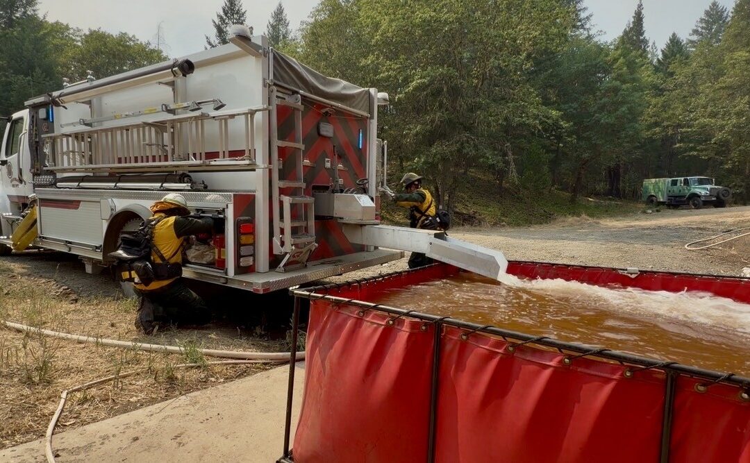
July 16, 2026
SAMS VALLEY, Ore.– Firefighters on the East Evans Creek Fire faced another afternoon of windy conditions, with gusts reaching up to 30 miles per hour. For the last couple of days on the incident, winds have fueled fire growth, but with cooler temperatures today, resources were able to hold the fire within its current footprint and even add new line around the fire’s perimeter to stop further growth. Work on all spot fires continued as well, with progress being made across the board. Winds are expected to continue into the evening, and firefighters will monitor for any changes on the line. The fire, including all spot fires, is currently 11,551 acres total and remains 5% contained.
Priority areas on the fire remain where homes and structures are located; today on the Canyon Creek spot fire closest to Shady Cove and Trail, firefighters made progress on both the wildland and structural side. On the spot fire itself, approximately 250 acres in size, wildland resources including four 20-person crews, two bulldozers, and two helicopters were able to completely line the perimeter directly at the fire’s edge. Crews will continue this work overnight to push forward on progress, strengthening the lines built today to keep the spot fire corralled.
Meanwhile, structural resources worked proactively on the outskirts of Shady Cove and Trail, preparing homes in the event of the fire approaching. Crews continued structure protection operations around homes, hardening properties and improving defensible space in neighborhoods impacted by the nearby spot fire. Additional strike teams also conducted structure triage in the Ramsey Creek area and preparation to enhance protection efforts. Crews will continue working overnight to strengthen the fire line, and structural engines will monitor areas around homes for signs of fire.
Firefighters also focused on the western edge of the main fire and the newest spot fire to the southwest, where homes are also nearby. Structural resources provided the same services to these homes, preparing where possible in the event the fire were to spread. Wildland firefighters were successful in lining this spot fire today as well, approximately 50 acres total, and continue to build line around the main fire in this area. Resources on tonight’s overnight shift will pick up where dayshift left off, working to hold and strengthen these established lines.
Across the rest of the fire, resources on the northern flank are holding the completed line, despite windy conditions. The spot fire on Board Mountain is currently lined on the northern section and along both sides; firefighters will continue to build line to halt any new progression on this spot fire. On the southern edge of the fire, mop-up operations continue. As these lines are connected and strengthened across the incident, overall containment will increase.
In coordination with wildland firefighters, structural engines supported operations by providing high-pressure pump systems to help improve water availability for crews using hoses on steep terrain. Structural protection plans have been coordinated across divisions to ensure an effective response to fire activity.
Tonight, temperatures are expected to cool down into the low- to mid-50s and relative humidity should increase, but winds will likely persist overnight. These conditions should help to moderate fire behavior, allowing firefighters to progress in their work to line the fire and minimize any new growth.
Evacuations: There are evacuations in place in both Jackson and Douglas counties, issued by both counties’ Sheriff’s Offices and Emergency Management. Up-to-date evacuations are available here: https://readyjacksonco.com/Emergency/emergency-information-hub-east-evans-creek-road-fire
Find your evacuation zone here: https://tinyurl.com/EastEvansCreekFireEvacMap
Road/Land Closures: The Tiller-Trail Highway is closed at the county border in Jackson County to Highway 62. Traffic is closed to the public on East Evans Creek Road at Meadows Road. The BLM has issued a road closure for West Fork Evans Creek Road and Rock Creek Road. Please avoid the fire area to allow firefighters and heavy equipment to operate safely. Road closure information is available on https://tripcheck.com/
A closure order for BLM-administered lands near the East Evans Creek Fire is in place. Public entry, including hunting, hiking, and camping, is prohibited. More information about the closure, including a map, is available online at www.blm.gov/orwafire.
Smoke Impacts: Smoke from the East Evans Creek Fire may settle into valleys and other low-lying areas, reducing visibility and impacting air quality in nearby communities. Smoke conditions can change throughout the day as winds shift. Individuals sensitive to smoke should take appropriate precautions. For current air quality information and smoke forecasts, visit: https://fire.airnow.gov/.
Temporary Flight Restriction (TFR): A “TFR” is in place for the fire area daily (24 hours) until further notice. Complete information is available at https://tfr.faa.gov/tfr3/?page=detail_6_4915
Flying a drone near or around a wildfire is illegal and compromises the safety of both pilots and firefighters and interferes with firefighting efforts.
Cause: The fire started on Friday, July 10th at 2:41 p.m. after a car crashed into a power pole, sparking dry vegetation in the area. The Jackson County Sheriff’s Office is currently investigating the cause of the crash.
MediaRelDailyUpdate_PM_20260716_final

July 16, 2026
SAMS VALLEY, Ore. (July 16th, 2026) – Overnight, firefighters on the East Evans Creek Fire worked to limit growth of new spot fires and hold existing firelines. On the southern perimeter the fire spotted across East Evans Creek Road into an old fire scar northwest of Hull Mountain. On the eastern side of the fire the Board Mountain spot fire ignited a new spot fire to the east toward Canyon Creek.
Air tankers were used to slow the growth of the Canyon Creek spot fire while firefighters constructed fireline around much of its perimeter overnight. Today, crews will continue completing and strengthening that line. Four additional strike teams of Type 1 engines will arrive today to expand structure protection operations in the Ramsey Creek, Trail and Shady Cove areas, where firefighters are assessing homes, improving defensible space, and preparing for changing fire conditions.
Spot fires continue to challenge firefighters across the incident. The spot fire near Hull Mountain and the main fire edge in the southwest area of the fire were active overnight as firefighters worked to establish control line around the spot fire and secure the existing fireline. This work will continue today.
The southern area of the fire held overnight with wildland and structural firefighters continuing to mop-up around structures and increasing mop-up of the perimeter.
On the northern perimeter active fire behavior challenged fireline in the Morrison Creek area but was held within the existing footprint. Firefighters today will focus on ensuring the fire remains within the control line.
Unified Command resources continue coordinating structure protection and suppression efforts across the incident, ensuring firefighters and equipment remain strategically positioned as fire conditions evolve.
Today’s weather is favorable for firefighters with cooler temperatures, higher humidity and reduced winds. However, challenging weather is expected to return starting Friday with high temperatures and increased wind.
A closure order for BLM-administered lands near the East Evans Creek Fire is in place. Public entry, including hunting, hiking, and camping, is prohibited. More information about the closure, including a map, is available online at www.blm.gov/orwafire.
Smoke Impacts: Smoke from the East Evans Creek Fire may settle into valleys and other low-lying areas, reducing visibility and impacting air quality in nearby communities. Smoke conditions can change throughout the day as winds shift. Individuals sensitive to smoke should take appropriate precautions. For current air quality information and smoke forecasts, visit: https://fire.airnow.gov/.
Evacuations: The Jackson County Sheriff’s Office and Emergency Management have issued the following evacuations by level:
Evacuation Level 3 Go Now: JAC-109 / JAC-124 / JAC-126 / JAC-149B / JAC-127A is a zone split from JAC-127 along Hwy 227. JAC-127A along Highway 227 from the intersection of Highway 62 to Taylor road. And north on Highway 62 to River Heights Rd.
Evacuation Level 2 Be Set: JAC-111 / JAC-112 / JAC-127B / JAC-131 / JAC-132 / JAC-133 / JAC-134 / JAC-149A / JAC-148 / JAC-147 / JAC-016
Evacuation Level 1 Be Ready: JAC-036 / JAC-026 / JAC-014 / JAC-003 / JAC-004 / DOU-1012 / DOU-1015 / SHC-151 / SHC-152 / SHC-153 / SHC-154 / SHC-156 / SHC-157 / JAC-158
The evacuation shelter for residents and domestic pets has been moved to Eagle Point Middle School, 477 Reese Creek Road, Eagle Point. Horses can be taken to the Expo at 21 Penninger Road, Central Point, OR. For more information on evacuation levels or to find your evacuation zone, visit https://tinyurl.com/EastEvansCreekFireEvacMap. Expo staff and volunteers are prepared to receive horses; however, please call 541-776-7206 first to confirm space is available, as additional shelter locations may be activated. Owners should bring feed, water containers, and any necessary medications when possible. For livestock sheltering assistance, call 541-776-7206.
Road Closures: Traffic is closed to the public on East Evans Creek Road at Meadows Road. The BLM has issued a road closure for West Fork Evans Creek Road and Rock Creek Road. Please avoid the fire area to allow firefighters and heavy equipment to operate safely.
Temporary Flight Restriction (TFR): A “TFR” is in place for the fire area daily (24 hours) until further notice. Complete information is available at https://tfr.faa.gov/tfr3/?page=detail_6_4915. Flying a drone near or around a wildfire is illegal and compromises the safety of both pilots and firefighters and interferes with firefighting efforts.
The fire started on Friday, July 10th at 2:41 p.m. after a car crashed into a power pole, sparking dry vegetation in the area. The Jackson County Sheriff’s Office is currently investigating the cause of the crash.
MediaRelDailyUpdate_AM_20260716
pio_8x11_land_20260716_0725_EastEvansCreek_OR711S000039_0716Day