August 8, 2017
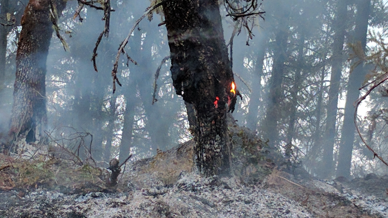
A force of more than 300 firefighters worked throughout the day to relocate fire lines on the northeast and northwest flanks of the Flounce Fire, burning on private and Bureau of Land Management forestlands roughly 12 miles northeast of Shady Cove. The fire grew along these flanks today but a wide bulldozer-constructed fire line along the southern end of the fire held as wind gusts put it to the test. Although a few spot fires were located outside of the western flank, they were knocked down and contained rapidly.
As of this evening, the Flounce Fire has reached 600 acres and is eight percent contained.
Fire camp was set up today at Touvelle State Park off Table Rock Road in Central Point. The park will remain closed to the public until further notice. Please be cautious of increased fire traffic throughout the area.
 Early this morning, a Level One (Be Ready) evacuation notice was issued by Jackson County Emergency Management for residents on Evergreen Drive and Lewis Road near Prospect. The evacuation order will remain in effect until further notice as a precautionary measure, as we anticipate additional thunderstorms this week. A structural protection strike team stood by today to protect homes and other structures in the event the wildfire posed a threat. The team is assembled from engines and personnel from fire districts in Jackson and Josephine counties.
 Overnight, the focus is to continue to improve control lines surrounding the homes under the evacuation order.
“We need to take advantage of the weather when we can. The fire did receive a fair amount of rain which means we have an opportunity to cover a lot of ground tonight,” said Herb Johnson, Flounce Fire Incident Commander.
Tomorrow at 5:00 a.m., the local ODF Southwest Oregon District Type 3 Incident Management Team will be handing off the Flounce Fire to the Oregon Department of Forestry Incident Management Team I. This will alleviate our local resources so that they can continue to have an aggressive initial attack throughout Jackson and Josephine Counties.
The Flounce Fire was first reported at 4:56 p.m. Monday. The cause is attributed to lightning that stemmed from a thunderstorm Monday afternoon.
Thunderstorms are anticipated for the next two days. With ODF Southwest Oregon District resources already stretched thin, we are encouraging everyone to hold each other responsible for following fire restrictions currently in place. Don’t let your actions become a statistic.
The fire danger level on Oregon Department of Forestry protected lands in Jackson and Josephine counties is “extreme” (red) today. For a full list of the public restrictions currently in place, visit our Facebook page: @ODFSouthwest or our website: www.swofire.com.
August 8, 2017
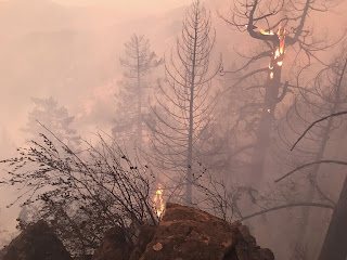
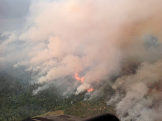
ODF Southwest firefighters worked throughout the night constructing fire line on the Flounce Fire, located approximately 12 miles northeast of Shady Cove. The Flounce Fire was first reported as two separate fires around 4:56 p.m. Monday. The main fire burned nearly 50 acres by sunset, and the two fires joined shortly after burning close to 200 acres by midnight. The lightning-sparked fire is approximately 250 acres this morning.
As of early this morning, a Level One (Be Ready) evacuation notice has been issued by Jackson County Emergency Management for residents on Evergreen Drive and Lewis Road near Prospect. A citizen alert has already been sent to the homes impacted by the notice. This is a precautionary measure, as we anticipate additional thunderstorms this week. There is a potential for growth along the northeast and northwest flanks of the fire; however, it is not anticipated to spread to the south toward the homes currently under the evacuation order due to the contingency line in place.
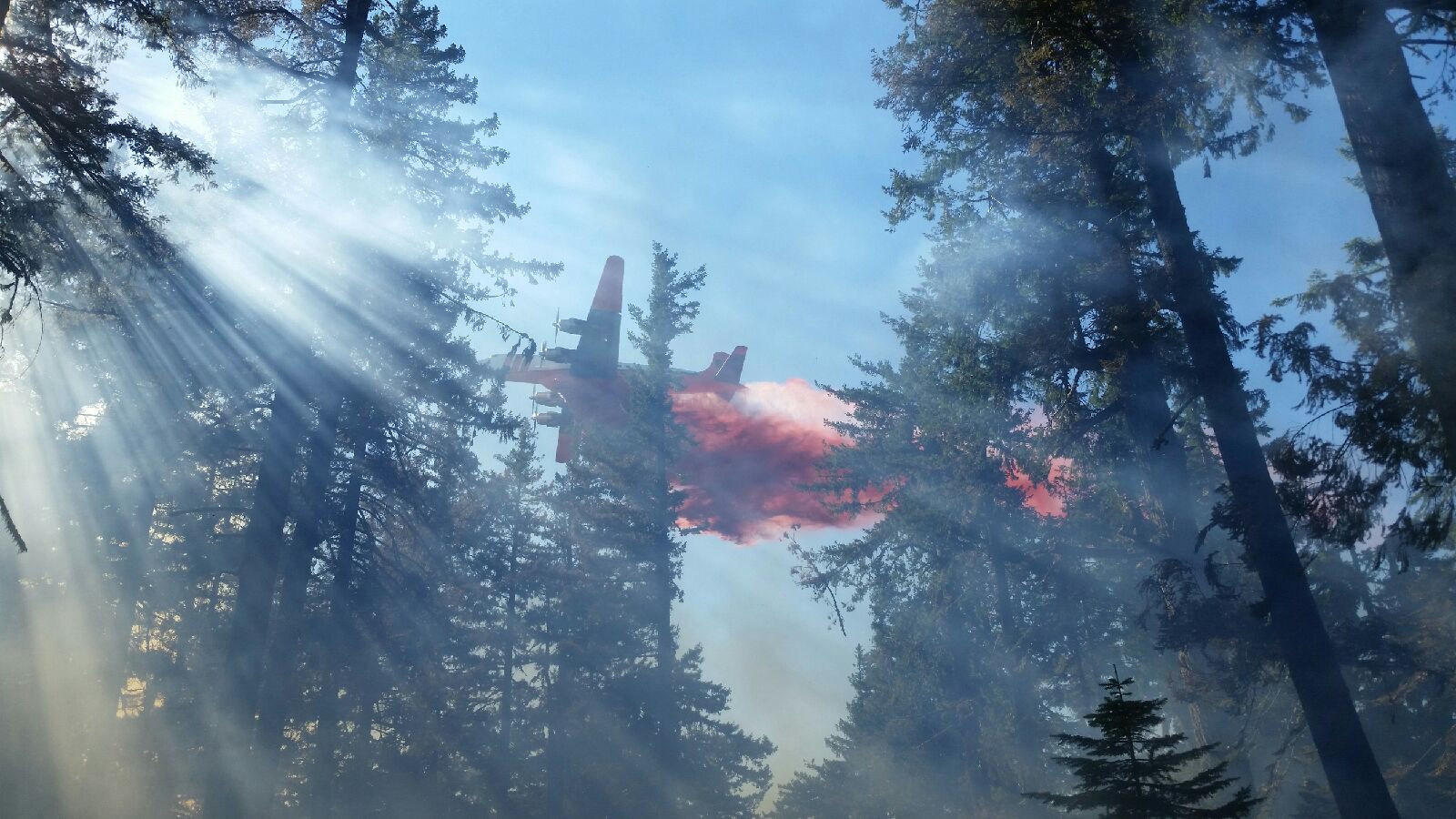
The topography ranges from moderate to very steep. The rugged terrain was one of the primary challenges over the past 12 hours. Still, crews were able to get one mile of hose lay in place in order to help control fire activity. Today, firefighters will continue to knock down the active portions of the fire, as well as continue building control line around the perimeter. Two Type One helicopters have been order for the fire, as well as four Type Two helicopters, one Large Air Tanker (LAT) and one air attack platform. Recon of the Flounce Fire is underway as of 9:00 a.m. this morning
Along with Oregon Department of Forestry crews from the Southwest Oregon District’s Medford and Grants Pass units, a Rogue Valley Strike Team was activated. The strike team consists of structural protection units from Jackson County Fire District 4, Jackson County Fire District 5, Jackson County Fire District 3, Medford Fire-Rescue, Jacksonville Fire and Ashland Fire-Rescue. Ten-man and 20-man crews are also on scene, and several Oregon Department of Corrections inmate crews have arrived to assist with fire line construction. In total, roughly 250 personnel are currently working the fire with more resources on the way.
Weather conditions today call for temperatures in the low 90’s, relative humidity is roughly 30 percent, and west winds at 3 mph. A Red Flag Warning has been issued from noon to 10 p.m. with abundant lightning in the forecast. With ODF Southwest Oregon District resources already stretched thin, we are encouraging everyone to hold each other responsible for following fire restrictions currently in place. Don’t let your actions become a statistic.
The fire danger level on Oregon Department of Forestry protected lands in Jackson and Josephine counties is “extreme” (red) today. For a full list of the public restrictions currently in place, visit our Facebook page: @ODFSouthwestor our website: www.swofire.com.
###
August 7, 2017
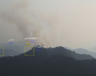
The
#FlounceFire, which is currently the largest, is estimated to be approximately 10 acres, located 2 miles northeast of Lost Creek Lake near Trail. The image of the Flounce Fire below was captured by our detection center earlier this afternoon. Several resources are being dedicated to this fire for an aggressive, initial attack. Please be cautious of
increased fire traffic in the area.
So far, the district has received over a dozen down strikes since 4:45 p.m., and the thunderstorm has not cleared our region yet. We will continue to be vigilant in our firefighting mission.
Additional contract crews are being requested in order to assist in searching for smokes and suppression efforts into the night.
August 1, 2017
Despite the challenging terrain and extreme heat, firefighters stopped and are holding the Long Gulch Fire at 2.5 acres tonight. The fire is 100 percent lined. The fire burning on Bureau of Land Management forestland is roughly two miles north of Bear Camp, west of the Rogue River Trail.
The initial report of smoke came in roughly around 1:00 p.m. Both our
ODF Southwest Oregon District detection cameras, and those of our p
artners north of us, the Douglas Forest Protective Association, picked up a light, wispy column forming near the Josephine-Curry County line. Immediately, aerial recon was dispatched to scout the fire behavior and an exact location for additional resources to respond. Due to the rugged nature of the terrain, aerial resources were determined to be the best source of initial action for the fire. This provided time to ground resources to search for access in the area.

In total, over 50 firefighters, two LATs (Large Air Tankers), one fixed-wing and five helicopters were involved in the direct attack on the Long Gulch Fire. While the conditions were prime for a potentially large wildfire, the aggressive initial attack by both air and ground resources was advantageous in today’s firefight.
As always, we would like to thank our partners for the contnuous cooperation. Today, the
U.S. Forest Service- Rogue River-Siskiyou National Forest assisted us with both air and ground resources that were essential to the success of this mission. We are proud to be a fantastic example of Oregon’s complete and coordinated system.
Tonight, all aircraft our on hold, but ground resources will continue searching for hot spots and mopping up overnight. The cause of the Long Gulch Fire is under investigation.
We are continuing to encourage everyone to know the fire restrictions in your area. Please visit our Facebook page:
ODF Southwest Oregon District, or our website,
www.swofire.com to learn more about what the “extreme” (red) fire danger level means for you and your family while out and about this summer. It’s up to all of us to do our part to prevent
#wildfires.
August 1, 2017
Both the Burnt Peak Fire, located roughly 13 miles northeast of Shady Cove, and the Savage Creek Fire, located off Savage Creek Road near Grants Pass, will both be in extensive mop up throughout the remainder of this week.
The 31-acre Burnt Peak Fire is now 67 percent contained. Firefighters mopped up 200 feet in from the fire’s edge over the past 24 hours. Crews will continue to search for hot spots in the steep terrain until they are certain the entirety of the fire is dead out.
The 3.3-acre Savage Creek Fire is 80 percent contain as of this afternoon. Smoke was visible throughout the day over this fire due to the amount of heat being released during mop up. This means, as firefighters continue to comb through the burned area, crews are turning over timber, debris and other hot spots in order to release any heat stored under the surface fuels.
For additional information on these fire, as well as visuals of what the firefighters have been facing on the ground, please visit our Facebook page: ODF Southwest.
Fire management officials ask that the public continue to use caution and adhere to fire restrictions. Current regulations for lands in Jackson and Josephine Counties protected by the Oregon Department of Forestry Southwest Oregon District can be found at www.swofire.com.
 Early this morning, a Level One (Be Ready) evacuation notice was issued by Jackson County Emergency Management for residents on Evergreen Drive and Lewis Road near Prospect. The evacuation order will remain in effect until further notice as a precautionary measure, as we anticipate additional thunderstorms this week. A structural protection strike team stood by today to protect homes and other structures in the event the wildfire posed a threat. The team is assembled from engines and personnel from fire districts in Jackson and Josephine counties.