Firefighters on East Evans Creek Fire line Canyon Creek spot fire
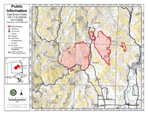
SAMS VALLEY, Ore. (July 17, 2026) – Overnight, firefighters were able to complete line construction on the Canyon Creek spot fire and establish firehose to the perimeter. Day shift crews will continue securing and strengthening the fireline today, using water to reduce heat near the fire’s edge. The Ramsey Creek spot fire remained within control lines constructed during day shift; firefighters worked overnight and will continue today to strengthen fireline and work to hold the fire in its current footprint.
Firefighters working on the Board Mountain spot fire were able to use natural fire progression and small-scale tactical burning to remove unburned fuel between the fire’s edge and the fireline on the northern perimeter as fire moved slowly up to the constructed indirect fireline. Today, firefighters will work to strengthen this fireline. The southern area of this fire continues to have active fire behavior southwest of Boswell Mountain. Additional resources are bolstering efforts in this area, working to construct and extend the direct fireline and address spot fires.
Structural resources maintained a presence throughout the East Evans Creek Fire area, including Long Branch Road, Shady Cove, Trail, East Evans Creek Road, West Fork Evans Creek Road, and the Hull Mountain area, continuing structure preparation, improved defensible space, completed structure assessments in additional neighborhoods, and extinguished lingering heat around threatened homes.
Mop-up on the southern edge of the main fire along East Evans Creek Road continues, as firefighters work to ensure the areas adjacent to homes and the fire perimeter have no residual heat. Today, firefighters will continue to work along the West Fork Evans Creek Road securing the fire’s edge and moving to the north to connect portions of fireline along the western edge of the fire. Fuels and vegetation in the area north of Spignet Butte have been receptive to embers and firefighters have been pushed to keep the fire from crossing the existing fireline. Efforts continue to focus on increasing fireline width to reduce potential ember wash across it, igniting fuels outside the line further securing the northern perimeter.
Structural engines supported wildland suppression efforts by operating high-pressure pump systems, water tenders, and portable water delivery equipment to firefighters working in steep terrain. A water supply site, supported by local agencies, has been established at the Dodge Bridge Boat Ramp to provide a reliable source of water for ongoing firefighting operations. To safely support these operations, the boat ramp is temporarily closed to public access.
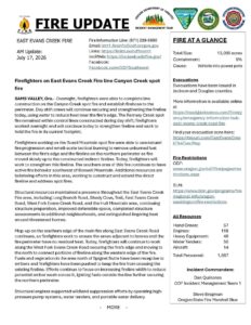
The fire remains 5% contained and is currently 13,090 acres total. Spot fires from embers carried by afternoon winds, combined with critically dry fuels, continue to challenge firefighters. Firefighters are covering nearly 60 miles of fire perimeter searching for areas of heat and opportunities to halt fire progression. Cooler temperatures overnight supported firefighting operations, reducing fire behavior and allowing direct line construction across much of the fire. An inversion over much of the fire will be slow to lift today, moderating fire behavior this morning, however fuels remain critically dry and receptive to ember ignition. Today, a warming, drying trend will return to the area, along with gusty northwest winds.
Fourteen helicopters are assigned to the fire to support ground operations by cooling and slowing fire progression with water drops and providing information on fire movement and spotting. Air tankers are available by request. Today’s inversion may limit aerial operations due to limited visibility.
Evacuations: There are evacuations in place in both Jackson and Douglas counties, issued by both counties’ Sheriff’s Offices and Emergency Management. Up-to-date evacuations are available here: https://readyjacksonco.com/…/emergency-information-hub…
Find your evacuation zone here: https://tinyurl.com/EastEvansCreekFireEvacMap
Road/Land Closures: The Tiller-Trail Highway is closed at the county border in Jackson County to Highway 62. Traffic is closed to the public on East Evans Creek Road at Meadows Road. The BLM has issued a road closure for West Fork Evans Creek Road and Rock Creek Road. Please avoid the fire area to allow firefighters and heavy equipment to operate safely. Road closure information is available on https://tripcheck.com/
A closure order for BLM-administered lands near the East Evans Creek Fire is in place. Public entry, including hunting, hiking, and camping, is prohibited. More information about the closure, including a map, is available online at www.blm.gov/orwafire
Smoke Impacts: Smoke from the East Evans Creek Fire may settle into valleys and other low-lying areas, reducing visibility and impacting air quality in nearby communities. Smoke conditions can change throughout the day as winds shift. Individuals sensitive to smoke should take appropriate precautions. For current air quality information and smoke forecasts, visit: https://fire.airnow.gov/
Temporary Flight Restriction (TFR): A “TFR” is in place for the fire area daily (24 hours) until further notice. Complete information is available at https://tfr.faa.gov/tfr3/?page=detail_6_4915
Flying a drone near or around a wildfire is illegal and compromises the safety of both pilots and firefighters and interferes with firefighting efforts.
Cause: The fire started on Friday, July 10th at 2:41 p.m. after a car crashed into a power pole, sparking dry vegetation in the area. The Jackson County Sheriff’s Office is currently investigating the cause of the crash.