September 13, 2025
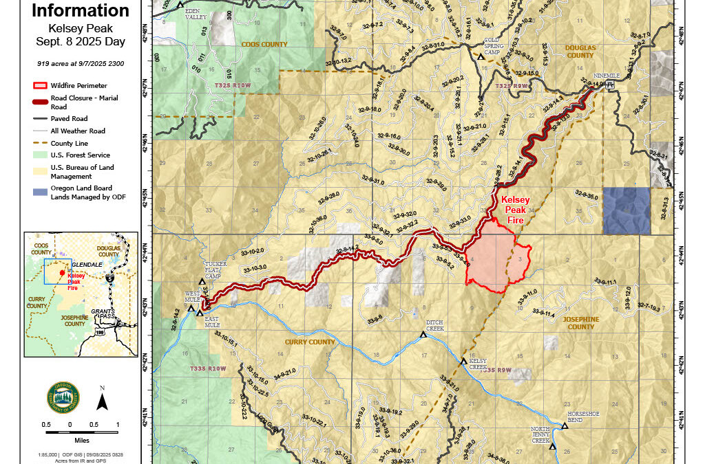
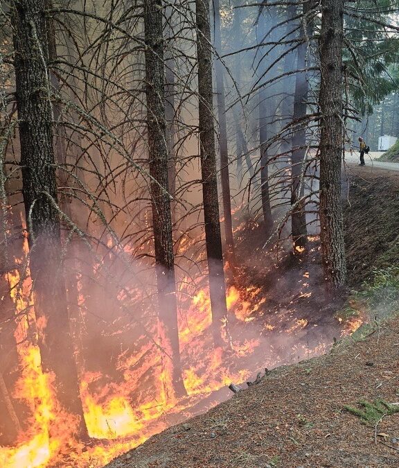
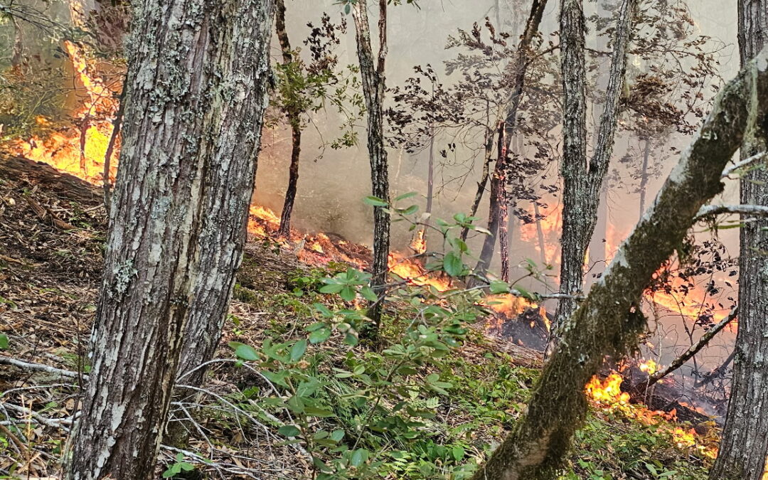
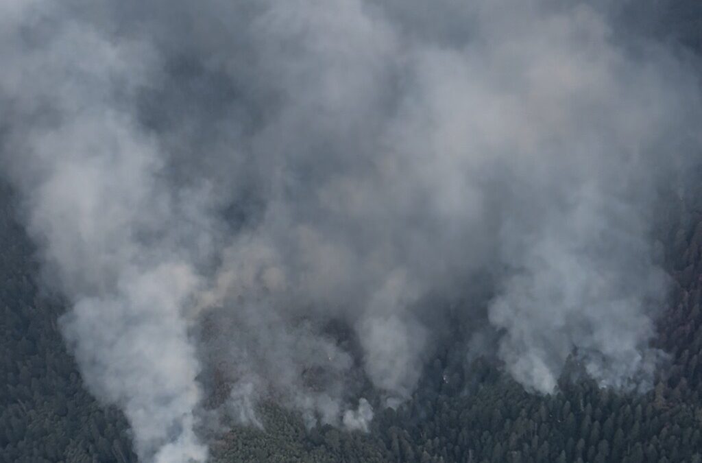
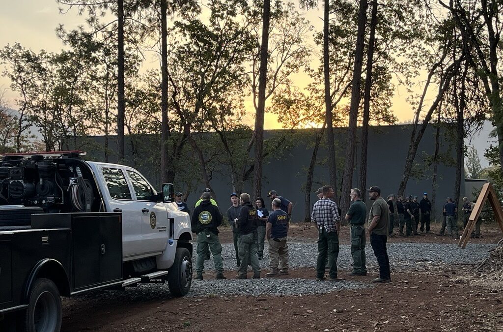
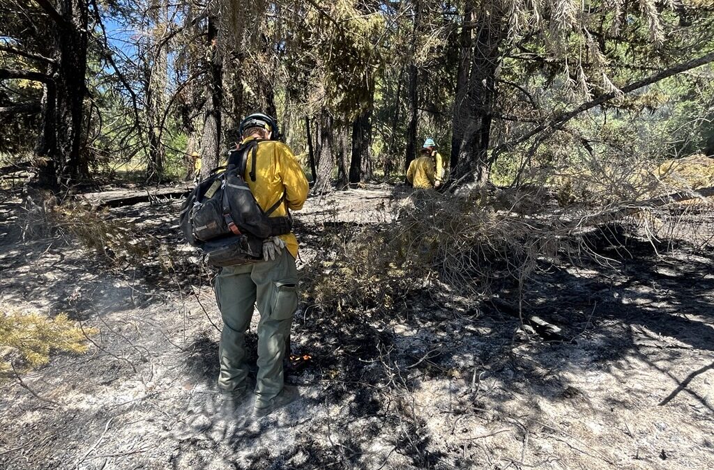
LOWER ROGUE RIVER CORRIDOR, Ore. – Firefighters on the Kelsey Peak Fire continue to push forward on strengthening lines and overall mop-up operations across the incident. The fire, located approximately 15 miles west of Glendale, is now 32% contained. This number is a direct reflection of the work firefighters have completed along the perimeter, extinguishing hotspots and bolstering the lines built to stop the fire’s growth.
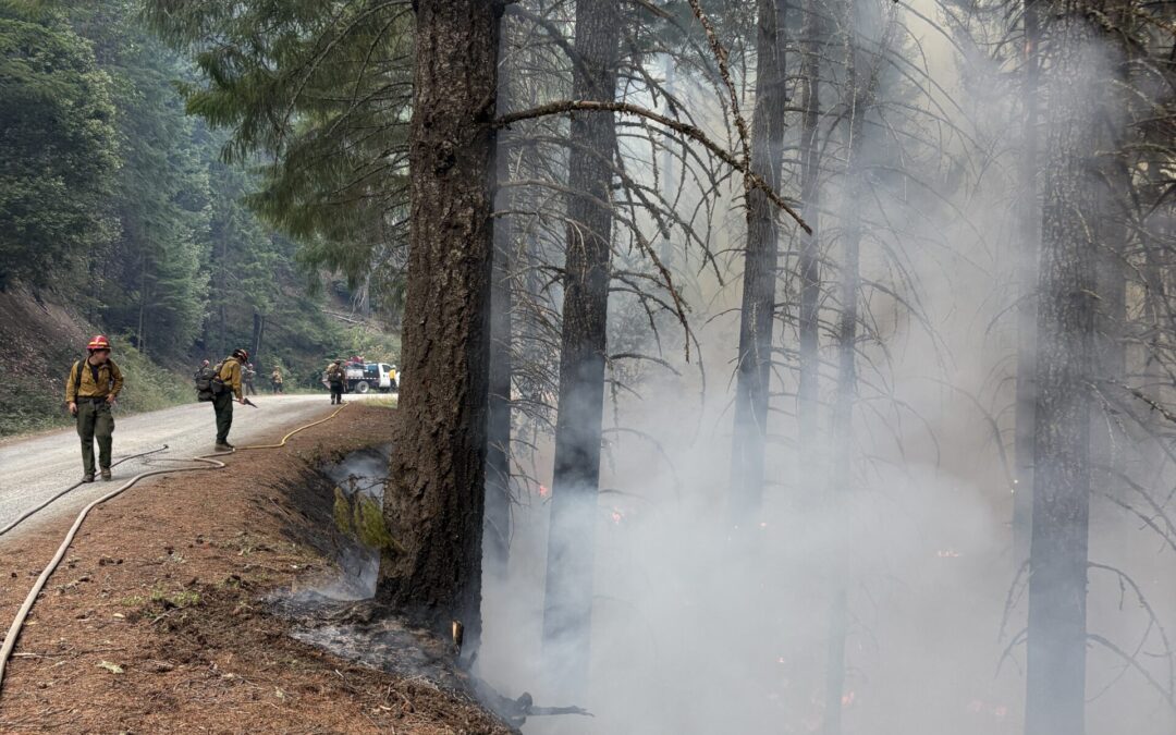
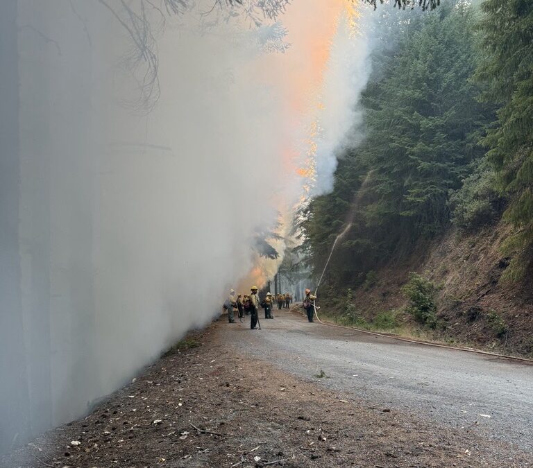
From the west side of the fire to the northeast flank, crews have mopped up 70-100 feet into the interior of the fireline. On the east and south sides, a mix between bulldozer and hand-dug line is being strengthened. This work continued overnight and will again be the focus for Saturday. Infrared (IR) technology continues to be used to find areas still holding heat; with these locations mapped, firefighters can work more safely and efficiently to extinguish vegetation and roots that could flare up in warmer, windy conditions.
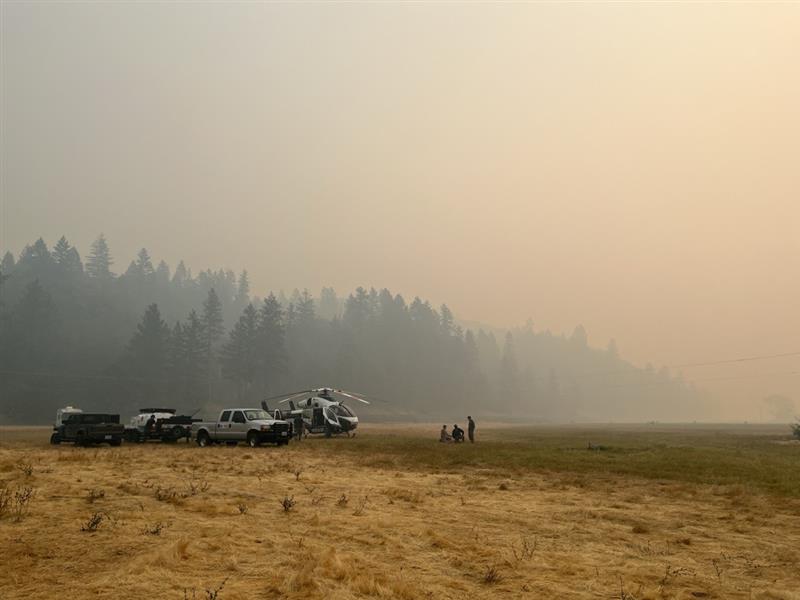
A Type 1 helicopter was also used yesterday to help extinguish hotspots. While aircraft can be helpful in remote locations, water bucket drops on the steep terrain can loosen trees and rocks and create a hazard for firefighters working on the line below. For that reason, aircraft have been used strategically, and sometimes sparingly, as the majority of work that needs to be completed requires firefighters on the ground.
Weather conditions are expected to heat up into the 80s once again on Saturday, giving firefighters an opportunity to see how their lines are holding. The heat will also help to naturally expose lingering hotspots that may begin smoking again in warmer temperatures. Tonight, a slight chance of rain and thunderstorms is possible, with storm chances holding through Sunday and warmer weather expected again next week.
Oregon Department of Forestry (ODF) Complex Incident Management Team 1, assigned to the Kelsey Peak Fire since last Monday, is working in coordination with the Great Basin Complex Incident Management Team 5 on the Moon Complex, approximately eight miles to the west. Due to closer proximity and easier road access, ODF Team 1 has been providing structure protection to the Zane Grey Cabin, the Rogue River Ranch and the area of Marial. Firefighters are also scouting for contingency lines in the event the Moon Complex fires move further east toward these areas. For more information on the Moon Complex, visit https://www.facebook.com/SWORFireInfo
Rogue River Access: Fire activity can drastically alter the river environment. Mitigation measures may be in place. It’s an evolving situation and updates will be shared as soon as possible. Permitted boaters can contact the BLM Smullin Visitor Center at 541-618-2408 or BLM_OR_MD_Rogue_River_Mail@blm.gov with questions about the status of the river.
Closures: The Rogue River Trail is closed from Horseshoe Bend to Flora Dell. A temporary closure of a portion of the Grave Creek to Marial Backcountry Byway (BLM Road 32-9-14.2) has been implemented by the BLM Grants Pass Field Office. The public is strongly encouraged to avoid the entire Byway to facilitate safe firefighter access on the steep, narrow, windy road. Unauthorized individuals may not enter closed areas, and all uses—including hiking, hunting and dispersed camping—are prohibited. Please see the map for full closure information on the BLM website: https://www.blm.gov/programs/public-safety-and-fire/fire-and-aviation/regional-info/oregon-washington/fire-restrictions
Evacuations: The Curry County Sheriff’s Office decreased the Level 3 – GO NOW evacuation order for the area of Rogue River Ranch, Tucker Flat Campground and the nearby area of Marial to a Level 2 – BE SET. The Josephine County Sheriff’s Office and Emergency Management has a Level 1 – BE READY evacuation notice for Zone JCU-801 in place. More info: https://tinyurl.com/KelseyPeakEvacs
Temporary Flight Restriction (TFR): A “TFR” is in place at an altitude from the surface up to and including 7,000 feet, daily (24 hours) until further notice. Complete information is available at https://tfr.faa.gov/tfr3/?page=detail_5_8274. Flying a drone near or around a wildfire compromises the safety of pilots and interferes with firefighting efforts.
Information for the Moon Complex is available here: https://tinyurl.com/MoonComplexInciweb.
September 12, 2025
LOWER ROGUE RIVER CORRIDOR, Ore. – Progress mopping up on the Kelsey Peak Fire has improved containment to 23%. This increased containment reflects the focused work crews have been accomplishing each day. Some portions of the fire have mopped up 100 feet into the interior of the fire.
“We aren’t building line out there to hold the fire today,” explained Operations Section Chief, Jason Pettigrew. “We are building line to hold the fire when its warmer and winds try to push it.”
Yesterday, helicopters were used to drop water on hot spots adjacent to the perimeter, moderating fire behavior and allowing firefighters to cool the area by stirring in water. They will be available again today for bucket work supporting firefighters and will be used to bring pumps and hose to the fireline in difficult terrain. This will improve water availability for mop-up.
Crews today are using infrared maps from an Unmanned Aircraft (UAS) flight late yesterday afternoon to identify areas of heat as they work around the fire’s edge mopping up. Using a drone (UAS) throughout the day provides immediate intel about hot spots to crews through updated maps, making mop up more efficient and improving safety as firefighters aren’t traversing the rugged terrain feeling for heat.
The Rogue River remains open for permitted boaters near the Kelsey Peak Fire, however firefighting activities may cause delays and smoke may limit visibility; boaters are encouraged to use caution on this part of the river.
Closures: The Rogue River Trail is closed from Horseshoe Bend to Flora Dell. A temporary closure of a portion of the Grave Creek to Marial Backcountry Byway (BLM Road 32-9-14.2) has been implemented by the BLM Grants Pass Field Office. The public is strongly encouraged to avoid the entire Byway to facilitate safe firefighter access on the steep, narrow, windy road. Unauthorized individuals may not enter closed areas, and all uses—including hiking, hunting and dispersed camping—are prohibited. Please see the map for full closure information on the BLM website: https://www.blm.gov/programs/public-safety-and-fire/fire-and-aviation/regional-info/oregon-washington/fire-restrictions
Evacuations: The Curry County Sheriff’s Office decreased the Level 3 – GO NOW evacuation order for the area of Rogue River Ranch, Tucker Flat Campground and the nearby area of Marial to a Level 2 – BE SET. The Josephine County Sheriff’s Office and Emergency Management has a Level 1 – BE READY evacuation notice for Zone JCU-801 in place. More info: https://tinyurl.com/KelseyPeakEvacs
Temporary Flight Restriction (TFR): A “TFR” is in place at an altitude from the surface up to and including 7,000 feet, daily (24 hours) until further notice. Complete information is available at https://tfr.faa.gov/tfr3/?page=detail_5_8274. Flying a drone near or around a wildfire compromises the safety of pilots and interferes with firefighting efforts.
Information for the Moon Complex is available here: https://tinyurl.com/MoonComplexInciweb.

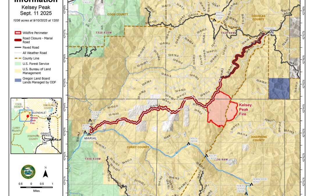
September 11, 2025
LOWER ROGUE RIVER CORRIDOR, Ore. – Crews on the Kelsey Peak Fire completed control lines along the eastern edge of the fire from the East Fork of Kelsey Creek to the main Kelsey Creek drainage. Connecting the control line on the southern end of the fire to both the Kelsey Creek drainage on the east and the existing fireline on the western edge of the fire will be completed today. The southern area is rocky and steep; challenging fireline construction and access to the fire.
Firefighters will transition their focus today to mop-up around the fire, securing the perimeter. Overnight, an infrared flight over the fire identified areas of heat within the perimeter. Crews will use these maps to focus work on hot spots adjacent to the control line. Aircraft will be supporting operations today as needed and available to respond to new fires in the area.
Fire behavior is expected to increase today through Saturday as temperatures warm and fuels begin to dry out. This change in weather will help firefighters identify areas of heat as they mop-up adjacent to the fireline. Gridding for heat and extinguishing hotspots is difficult and especially challenging in the steep terrain. Despite recent rainy, cool weather, firefighters are finding heat in larger fuels and fire burning roots and organic material deep in the soil.
Oregon Department of Forestry’s Complex Incident Management Team 1 continues to focus on minimizing impacts of the Kelsey Peak Fire on the Lower Rogue River corridor, surrounding historic and private structures, cultural and environmental resources, and communities near the fire. Resource advisors are working with the team to provide input for protection of sensitive areas during suppression activities.
The Rogue River remains open for permitted boaters near the Kelsey Peak Fire. Firefighting activities on the Kelsey Peak Fire may cause delays; boaters are encouraged to use caution on this part of the river.
Closures: The Rogue River Trail is closed from Horseshoe Bend to Flora Dell. A temporary closure of a portion of the Grave Creek to Marial Backcountry Byway (BLM Road 32-9-14.2) has been implemented by the BLM Grants Pass Field Office. The public is strongly encouraged to avoid the entire Byway to facilitate safe firefighter access on the steep, narrow, windy road. Unauthorized individuals may not enter closed areas, and all uses—including hiking, hunting and dispersed camping—are prohibited. Please see the map for full closure information on the BLM website: https://www.blm.gov/programs/public-safety-and-fire/fire-and-aviation/regional-info/oregon-washington/fire-restrictions
Evacuations: The Curry County Sheriff’s Office decreased the Level 3 – GO NOW evacuation order for the area of Rogue River Ranch, Tucker Flat Campground and the nearby area of Marial to a Level 2 – BE SET. The Josephine County Sheriff’s Office and Emergency Management has a Level 1 – BE READY evacuation notice for Zone JCU-801 in place. More info: https://tinyurl.com/KelseyPeakEvacs
Temporary Flight Restriction (TFR): A “TFR” is in place at an altitude from the surface up to and including 7,000 feet, daily (24 hours) until further notice. Complete information is available at https://tfr.faa.gov/tfr3/?page=detail_5_8274. Flying a drone near or around a wildfire compromises the safety of pilots and interferes with firefighting efforts.
Information for the Moon Complex is available here: https://tinyurl.com/MoonComplexInciweb.
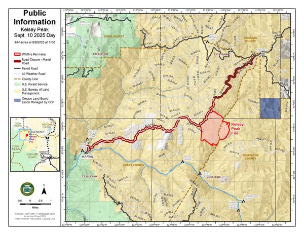
September 10, 2025
LOWER ROGUE RIVER CORRIDOR, Ore. – Continued hard work by firefighters on the Kelsey Peak Fire, 15 miles west of Glendale, has increased containment to 12% for the incident. Control lines have been completed along the west, north, and northeast areas of the fire. Fireline has been constructed directly on the fire’s edge in these areas, and crews are mopping up into the interior and gridding for heat.
Steep, rugged terrain and thick vegetation make both line construction and mop-up challenging for fire crews. There have been no accidents or injuries on the incident since the fire was reported on September 3, 2025.
Crews continue working to secure the perimeter of the fire as weather transitions to warmer and drier conditions. Nearly ¾ of an inch of rain has fallen across the incident in the last 36 hours, temporarily reducing fire behavior, but as fuels begin to dry smoke and flames will be more visible. Reduced fire behavior is allowing crews to construct the line at the fire’s edge, minimizing the overall size of the fire. An infrared flight overnight showed hotspots along the east perimeter where crews are working to connect control lines and increase the mop-up depth adjacent to the fireline.
Overnight improved access to the southeast corner of the fire was completed; today crews will continue direct fireline construction as conditions allow and build hoselays, increasing water availability for mop-up along the control lines.
“It was a great night!” Brent O’Nion, Night Operations Section Chief, stated during the morning operational briefing. “Night crews built off the work you guys put in yesterday, extending the mop-up depth and getting into Kelsey Creek to begin direct handline construction on the southeast corner!”
Nine helicopters are assigned to the fire to support ground resources in the suppression efforts. Smoke has limited visibility, but as conditions improve, they will engage. Air resources from the Kelsey Peak Fire are also supporting initial attack activities in coordination with local agencies.
The Rogue River remains open for permitted boaters near the Kelsey Peak Fire, however further downriver, restrictions are in place. Additional information is available here: https://tinyurl.com/MoonComplexInciweb
Firefighting activities on the Kelsey Peak Fire may cause delays; boaters are encouraged to use caution on this part of the river.
Closures: The Rogue River Trail is closed from Horseshoe Bend to Flora Dell. A temporary closure of a portion of the Grave Creek to Marial Backcountry Byway (BLM Road 32-9-14.2) has been implemented by the BLM Grants Pass Field Office. The public is strongly encouraged to avoid the entire Byway to facilitate safe firefighter access on the steep, narrow, windy road. Unauthorized individuals may not enter closed areas, and all uses—including hiking, hunting and dispersed camping—are prohibited. Please see the map for full closure information on the BLM website: https://www.blm.gov/programs/public-safety-and-fire/fire-and-aviation/regional-info/oregon-washington/fire-restrictions
Evacuations: The Curry County Sheriff’s Office decreased the Level 3 – GO NOW evacuation order for the area of Rogue River Ranch, Tucker Flat Campground and the nearby area of Marial to a Level 2 – BE SET. The Josephine County Sheriff’s Office and Emergency Management has a Level 1 – BE READY evacuation notice for Zone JCU-801 in place. More info: https://tinyurl.com/KelseyPeakEvacs
Temporary Flight Restriction (TFR): A “TFR” is in place at an altitude from the surface up to and including 7,000 feet, daily (24 hours) until further notice. Complete information is available at https://tfr.faa.gov/tfr3/?page=detail_5_8274. Flying a drone near or around a wildfire compromises the safety of pilots and interferes with firefighting efforts.
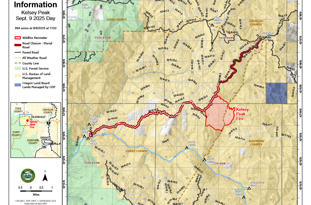
September 9, 2025
This will be the final evening update unless conditions significantly change
LOWER ROGUE RIVER CORRIDOR, Ore. – Resources assigned to the Kelsey Peak Fire continued to push forward on lining the perimeter Tuesday, making headway from the northwestern to the northeastern sides of the incident. Cooler temperatures and intermittent rain has naturally helped to decrease fire behavior, providing opportunities for firefighters to make fast progress in areas that once proved difficult in hotter weather and more active fire. It’s also allowing firefighters to put in direct line up against the fire’s edge, keeping the fire as small as possible and minimizing further growth.
Due to the current conditions, minimized fire behavior and work completed by resources on the line, the Curry County Sheriff’s Office has decreased the Level 3 – Go Now evacuation for the Rogue River Ranch, Tucker Flat Campground and the nearby area of Marial to a Level 2 – Be Set notice. The Level 1 – Be Ready evacuation for Zone JCU-801 in Josephine County to the southeast of the fire remains in place.
Today, resources furthered plans of protection for these structures in the Level 2 evacuation area, as well as the Zane Grey Cabin. These procedures are precautionary, however with multiple fires in the area, firefighters are taking every opportunity possible to ensure plans are in place, especially with residents and guests returning.
Meanwhile, mop-up operations are continuing on the northeastern lines, reaching up to 70-feet into the interior of the fire. This work ensures all lingering heat is extinguished and won’t flare up again in warm, windy weather, expected by the end of this week. As lines are connected and solidified, mop-up work will begin on other portions of the fire, boosting containment across the incident.
The Rogue River remains open for permitted boaters near the Kelsey Peak Fire, however further downriver, restrictions are in place. Additional information is available here: https://tinyurl.com/MoonComplexInciweb
Firefighting activities on the Kelsey Peak Fire may cause delays; boaters are encouraged to use caution on this part of the river.
Closures: The Rogue River Trail is closed from Horseshoe Bend to Flora Dell. A temporary closure of a portion of the Grave Creek to Marial Backcountry Byway (BLM Road 32-9-14.2) has been implemented by the BLM Grants Pass Field Office. The public is strongly encouraged to avoid the entire Byway to facilitate safe firefighter access on the steep, narrow, windy road. Unauthorized individuals may not enter closed areas, and all uses—including hiking, hunting and dispersed camping—are prohibited. Please see the map for full closure information on the BLM website: https://www.blm.gov/programs/public-safety-and-fire/fire-and-aviation/regional-info/oregon-washington/fire-restrictions
Evacuations: The Curry County Sheriff’s Office decreased the Level 3 – GO NOW evacuation order for the area of Rogue River Ranch, Tucker Flat Campground and the nearby area of Marial to a Level 2 – BE SET. The Josephine County Sheriff’s Office and Emergency Management issued a Level 1 – BE READY evacuation notice Zone JCU-801. More info: https://tinyurl.com/KelseyPeakEvacs
Temporary Flight Restriction (TFR): A “TFR” is in place at an altitude from the surface up to and including 7,000 feet, daily (24 hours) until further notice. Complete information is available at https://tfr.faa.gov/tfr3/?page=detail_5_8274. Flying a drone near or around a wildfire compromises the safety of pilots and interferes with firefighting efforts.
September 9, 2025
LOWER ROGUE RIVER CORRIDOR, Ore. – Rain over the Kelsey Peak Fire beginning late Monday evening continued, moderating fire behavior across the incident overnight. Firefighters were able to focus on mop-up into the interior of the fire on the western edge and bulldozers were used to extend the control line southward. Today firefighters will work to find terrain features along the southern perimeter to construct control lines connecting to the western edge.
Mop-up along the northern control line extended up to 50 feet into the interior on the northwest corner. Crews were able to expose areas of heat buried such as burning roots, using higher humidity and water to extinguish the hotspots. Today resources will continue this work moving further along the control line to secure the fire.
Rain showers are expected today, aiding in suppression efforts, however afternoon thunderstorms could bring erratic winds over the fire. Firefighters were reminded at briefing that the rainy conditions increase hazards in the fire area, and they need to be mindful as they work. Incident objectives for Oregon Department of Forestry’s Complex Incident Management Team 1 include prioritizing public and firefighter safety during suppression activities.
On the eastern side of the fire, crews and equipment have improved access and are constructing fireline adjacent to the fire’s edge where possible in the rugged terrain. Overnight handline was completed from the jeep trail in the northeast corner of the fire down to Kelsey Creek; today efforts will focus on building line from the jeep trail toward East Fork of Kelsey Creek.
The Rogue River remains open for permitted boaters near the Kelsey Peak Fire, however further downriver, restrictions are in place. Additional information is available here: https://tinyurl.com/MoonComplexInciweb
Firefighting activities on the Kelsey Peak Fire may cause delays, boaters are encouraged to use caution on this part of the river.
Closures: The Rogue River Trail is closed from Horseshoe Bend to Flora Dell. A temporary closure of a portion of the Grave Creek to Marial Backcountry Byway (BLM Road 32-9-14.2) has been implemented by the BLM Grants Pass Field Office. The public is strongly encouraged to avoid the entire Byway to facilitate safe firefighter access on the steep, narrow, windy road. Members of the public may not enter closed areas, and all uses—including hiking, hunting and dispersed camping—are prohibited. Please see the map for full closure information on the BLM website: https://www.blm.gov/programs/public-safety-and-fire/fire-and-aviation/regional-info/oregon-washington/fire-restrictions
Evacuations: The Curry County Sheriff’s Office issued a Level 3 – GO NOW evacuation order for the area of Rogue River Ranch, Tucker Flat Campground and the nearby area of Marial. The Josephine County Sheriff’s Office and Emergency Management issued a Level 1 – BE READY evacuation notice Zone JCU-801. More info: https://tinyurl.com/KelseyPeakEvacs
Temporary Flight Restriction (TFR): A “TFR” is in place at an altitude from the surface up to and including 7,000 feet, daily (24 hours) until further notice. Complete information is available at https://tfr.faa.gov/tfr3/?page=detail_5_8274. Flying a drone near or around a wildfire compromises the safety of pilots and interferes with firefighting efforts.
September 9, 2025
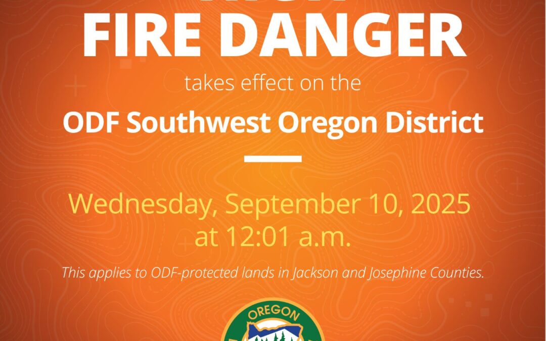
JACKSON & JOSEPHINE COUNTIES, Ore. (Sept. 9, 2025) – Due to cooler temperatures and light rain overnight and in the forecast, the fire danger level on lands protected by the Oregon Department of Forestry Southwest Oregon District will decrease to “high” (yellow) on Wednesday, September 10, 2025 at 12:01 a.m. This affects 1.8 million acres of state, private, county and Bureau of Land Management lands in Jackson and Josephine counties. The Industrial Fire Precaution Level (IFPL) will remain at Level 2 (two).
The primary difference between current fire prevention restrictions and those beginning on Wednesday affects the public use of power-driven equipment, such as chainsaws, mowers, weed eaters, and more. The use of power-driven equipment, grinding, cutting of metal, and other spark-emitting equipment, such as wood splitters and generators, will now be allowed until 10 a.m. and after 8 p.m. daily. Mowing green lawns are allowed at anytime.
Other fire prevention regulations which will remain in effect, include:
- No debris burning, including piles and debris burned in burn barrels
- No fireworks on or within 1/8th of a mile of ODF-protected land. Fireworks are prohibited on all BLM land
- Exploding targets and tracer ammunition, or any bullet with a pyrotechnic charge in its base, are prohibited
- Campfires are allowed only in designated campgrounds. Portable stoves or fire pits using liquefied or bottled fuels may be used in other locations that are clear of dry vegetation.
- Motorized vehicles, including motorcycles and all-terrain, are allowed only on improved roads; one shovel and one gallon of water, or one 2.5 pound or larger fire extinguisher, is required while traveling
- Smoking while traveling will only be allowed in enclosed vehicles on improved roads, in boats on the water and other specifically designated locations
- Chain saws may not be used between 10:00 a.m. and 8:00 p.m. during high fire danger. During hours outside of this time frame, chain saws may be used but require that the operator have one shovel and one 8-oz or larger fire extinguisher at the work site. A fire watch is also required for one hour after each chainsaw use
- Cutting, grinding, and welding of metal is not allowed between 10:00 a.m. and 8:00 p.m. during high fire danger. These activities will be allowed during hours outside of this time frame only if the work site is cleared of potentially flammable vegetation and other materials, and a water supply is at the job site
- The mowing of dead or dried grass with power-driven equipment is not allowed between 10:00 a.m. and 8:00 p.m. during high fire danger. This includes the use of electric, battery and gas-powered equipment. This restriction does not include mowing of green lawns, or equipment used for the commercial culture and harvest of agricultural crops
- Any other spark-emitting internal combustion engine-use not specifically mentioned is not allowed between 10:00 a.m. and 8:00 p.m. during high fire danger. Use of any spark-emitting internal combustion engine is allowed outside of this time frame only if the work site is cleared of potentially flammable vegetation and other materials, and a water supply is at the job site
- Any electric fence controllers must be approved by a nationally recognized testing laboratory, such as Underwriters Laboratories Inc., or be certified by the Department of Consumer and Business Services, and be installed and used in compliance with the fence controller’s instructions for fire safe operation
For more information about the Oregon Department of Forestry’s fire season public restrictions, please call or visit the Southwest Oregon District unit office nearest to you:
- Medford Unit, 5286 Table Rock Rd., Central Point. (541) 664-3328
- Grants Pass Unit, 5375 Monument Dr., Grants Pass. (541) 474-3152
BLM fire restrictions are available here: https://www.blm.gov/programs/public-safety-and-fire/fire-and-aviation/regional-info/oregon-washington/fire-restrictions
Fire season information is also available online at our Facebook page, @ODFSouthwest and our website, www.swofire.com.
September 8, 2025
LOWER ROGUE RIVER CORRIDOR, Ore. – Firefighters continued to build line Monday on the Kelsey Peak Fire, located on Bureau of Land Management (BLM) land approximately 15 miles west of Glendale. The western portions of line are holding well, and crews on the north and northwest areas worked to connect lines today. These operations are key to keeping the fire as small as possible and stopping its growth, which remains a top priority for the Oregon Department of Forestry (ODF) Complex Incident Management Team (CIMT) 1 assigned to the incident, as well as the ODF Southwest Oregon District and BLM Medford District.
This morning, minimal fire growth was observed on the southwest and east sides of the fire; firefighters worked to keep the fire from spreading further in these areas. Changes in the weather were felt in the late afternoon, with cooler temperatures and showers observed by firefighters on the line, as well as thunderstorms over the fire and across southern Oregon.
While the rain is helpful in naturally slowing fire growth, it won’t extinguish the fire; firefighters are capitalizing on the decreased fire activity and pushing forward in their work. Rain and thunderstorms remain in the forecast in the coming days, creating the potential for new lightning-caused fire starts. Kelsey Peak Fire resources are available to support the initial attack of new wildfires as needed.
Tonight, resources will continue to focus on connecting lines around the fire and bolstering their strength where possible. As this work continues, containment on the fire will begin to be reflected.
The fire is burning north of the Rogue River along the Kelsey Creek drainage on steep terrain with dense vegetation, limited road access, and numerous hazards, including falling trees, rolling debris and snakes. Public and firefighter safety are top priorities on this incident.
The Rogue River remains open for permitted boaters near the Kelsey Peak Fire, however further downriver, restrictions are in place. Additional information is available here: https://tinyurl.com/MoonComplexInciweb
In the area of the Kelsey Peak Fire, firefighting activities may cause delays on the river.
Closures: The Rogue River Trail is closed from Horseshoe Bend to Flora Dell. A temporary closure of a portion of the Grave Creek to Marial Backcountry Byway (BLM Road 32-9-14.2) has been implemented by the BLM Grants Pass Field Office. The public is strongly encouraged to avoid the entire Byway to facilitate safe firefighter access on the steep, narrow, windy road. Members of the public may not enter closed areas, and all uses—including hiking, hunting and dispersed camping—are prohibited. Please see the map for full closure information on the BLM website: https://www.blm.gov/programs/public-safety-and-fire/fire-and-aviation/regional-info/oregon-washington/fire-restrictions
Evacuations: The Curry County Sheriff’s Office issued a Level 3 – GO NOW evacuation order for the area of Rogue River Ranch, Tucker Flat Campground and the nearby area of Marial. The Josephine County Sheriff’s Office and Emergency Management issued a Level 1 – BE READY evacuation notice Zone JCU-801. More info: https://tinyurl.com/KelseyPeakEvacs
Temporary Flight Restriction (TFR): A “TFR” is in place at an altitude from the surface up to and including 7,000 feet, daily (24 hours) until further notice. Complete information is available at https://tfr.faa.gov/tfr3/?page=detail_5_8274. Flying a drone near or around a wildfire compromises the safety of pilots and interferes with firefighting efforts.

September 8, 2025
LOWER ROGUE RIVER CORRIDOR, Ore. – Oregon Department of Forestry’s (ODF) Complex Incident Management Team 1, Incident Commander Dan Quinones, assumed command of the Kelsey Peak Fire today at 6:00 a.m. Resources from the Bureau of Land Management (BLM) Medford District and ODF’s Southwest Oregon District have made significant progress constructing containment lines on the Kelsey Peak Fire since it was sparked by lightning last week. The fire is burning on BLM administered lands in rugged terrain with dense vegetation, limited access, and large overstory trees north of the Rogue River along the Kelsey Creek drainage.
Transitioning command of the fire to Team 1 brings additional capacity and resources to the incident and allows local firefighters to rest and be available to respond to new fires. The weather forecast for the week includes cooler temperatures, precipitation and the threat of more lightning.
Fire crews today will take advantage of the cooler, damp weather to further strengthen existing control lines, identify potential features and points to establish direct control lines, and building line adjacent to the fire’s edge, minimizing fire size. Smoky conditions have limited the use of aircraft on the fire over the last several days, as conditions allow, they will be used to support firefighters on the ground. Eight helicopters are assigned to the incident.
On the west side of the fire, control lines will be extended with bulldozers south from BLM Road 32-9-14.2, while firefighters look for opportunities to build direct line along the southern edge of the fire. Overnight, access to the northeast corner of the fire was improved as bulldozers worked to open a roadway for firefighter travel. Better access to this area of the fire will allow construction of direct control line along the northern edge of the fire and the east side of the fire working south toward the East Fork of Kelsey Creek.
“We have a window of opportunity to take strong action on the fire,” commented Incident Commander Quinones during the day shift planning meeting. “Moderated fire behavior will allow us to go after the fire in its existing footprint.”
While focusing on the full suppression operational objectives of the incident, special consideration will be given to the protection of cultural and historic resources in the area, public and firefighter safety, and minimizing impacts to the natural characteristics of the Rogue River and its tributaries. The Rogue River remains open for permitted boaters, however firefighting activities in the area could cause delays.
Firefighting resources from the Kelsey Peak Fire are available to support local agency’s initial attack of new wildfires.
Closures: The Rogue River Trail is closed from Horseshoe Bend to Flora Dell. A temporary closure of a portion of the Grave Creek to Marial Backcountry Byway (BLM Road 32-9-14.2) has been implemented by the BLM Grants Pass Field Office. The public is strongly encouraged to avoid the entire Byway to facilitate safe firefighter access on the steep, narrow, windy road. Members of the public may not enter closed areas, and all uses—including hiking, hunting and dispersed camping—are prohibited. Please see the map for full closure information on the BLM website: https://www.blm.gov/programs/public-safety-and-fire/fire-and-aviation/regional-info/oregon-washington/fire-restrictions.
Evacuations: The Curry County Sheriff’s Office issued a Level 3 – GO NOW evacuation order for the area of Rogue River Ranch, Tucker Flat Campground and the nearby area of Marial. The Josephine County Sheriff’s Office and Emergency Management issued a Level 1 – BE READY evacuation notice Zone JCU-801. More info: https://tinyurl.com/KelseyPeakEvacs
Temporary Flight Restriction (TFR): A “TFR” is in place at an altitude from the surface up to and including 7,000 feet, daily (24 hours) until further notice. Complete information is available at https://tfr.faa.gov/tfr3/?page=detail_5_8274. Flying a drone near or around a wildfire compromises the safety of pilots and interferes with firefighting efforts.
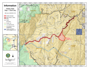
September 7, 2025
LOWER ROGUE RIVER CORRIDOR, Ore. (Sept. 7, 2025) – As firefighters remain engaged on the Kelsey Peak Fire, Oregon Department of Forestry (ODF) Complex Incident Management Team (CIMT) 1 was in-briefed on the incident by local leadership from the Bureau of Land Management (BLM) Medford District and ODF Southwest Oregon District. The fire, burning on BLM-administered land along the Lower Rogue River Corridor roughly 26 miles northwest of Grants Pass, was sparked by lightning during a thunderstorm last Wednesday night. ODF CIMT 1 is currently working with their counterparts to learn as much as possible about the fire, terrain, local historic structures, and communities before taking command of the incident on Monday morning. With the team transition, updates will begin to be available on the Kelsey Peak Fire 2025 Facebook page tomorrow.
Today, resources assigned to the fire improved work along existing control lines, bolstering these areas to create a strong barrier to stop the forward spread of the fire. Additionally, they were able to create new lines along the north and southeast portions. Smoky conditions have halted the use of aircraft for the past two days, but a window opened up around 5:30 p.m. and helicopters were able to assist firefighters on the ground.
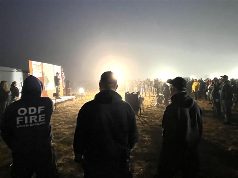
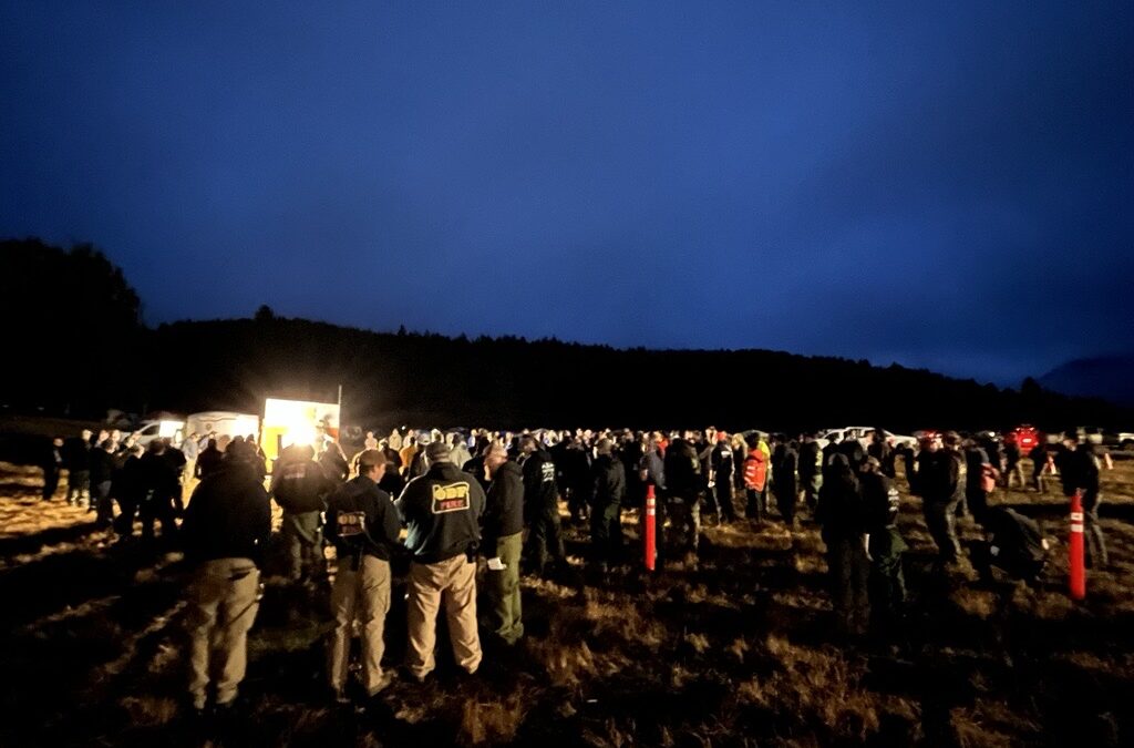
Tonight, resources will continue to push forward on building lines around the fire. This effort will help to keep it as small as possible, which remains a top priority, along with the safety of firefighters and the public. More than 150 personnel will be working on the fire overnight, including five 20-person crews, 13 engines, one bulldozer, two water tenders and medical staff.
Evacuations around the fire remain in place tonight. The Josephine County Sheriff’s Office and Emergency Management placed Zone JCU-801, located mostly southeast of the fire, on a Level 1, BE READY evacuation notice. In Curry County, Sheriff John Ward of the Curry County Sheriff’s Office issued a Level 3, GO NOW, evacuation order for the area of Rogue River Ranch, Tucker Flat Campground and the nearby area of Marial. The Rogue River Trail is closed from Horseshoe Bend to Flora Dell. A portion of the Grave Creek to Marial Backcountry Byway (BLM Road 32-9-14.2) is closed. The public is strongly encouraged to avoid the entire Byway to facilitate safe firefighter access on the steep, narrow, windy road. Members of the public may not enter closed areas, and all uses—including hiking, hunting and dispersed camping—are prohibited. Please see the map for full closure information on the BLM website: https://www.blm.gov/programs/public-safety-and-fire/fire-and-aviation/regional-info/oregon-washington/fire-restrictions.
Firefighters are also scouting the area for cabins and other historical locations in an effort to preserve them. While the Rogue River Ranch, Marial and the Zane Grey Cabin are near the general area of the fire, they are currently not threatened by it. The Level 3 evacuation affecting some of these structures is due to the limited road access currently threatened by the fire. Resources will continue to monitor fire behavior and take the steps necessary to keep these structures safe.
The fires along the Lower Rogue River Corridor were started by lightning during a thunderstorm last Wednesday; the following is a complete list of the fires that affected ODF-protected land:
| Fire |
Size (Acres) |
Status |
| August Knob Fire |
1/100 |
100% lined, 100% mopped up |
| Bald Ridge Fire |
— |
Unable to locate (UTL) |
| Bald Ridge Fire #2 |
1/4 |
100% lined, 100% mopped up |
| Big Meadow Fire |
1/10 |
100% lined, 100% mopped up |
| Cold Springs Fire |
1/10 |
100% lined, 100% mopped up |
| Ditch Creek Fire |
1/10 |
100% lined, 100% mopped up |
| Hewitt Creek Fire |
1/10 |
Turned over to USFS |
| Jeep Ridge Fire |
1/100 |
100% lined, 100% mopped up |
| Kelsey Peak Fire |
685 |
25% lined, 0% mopped up |
| Marial Fire |
1/2 |
100% lined, 100% mopped up |
| Mule Creek Fire |
2 |
100% lined, 100% mopped up |
| Quail Creek Fire |
1/10 |
100% lined, 100% mopped up |
Additional fires burning downriver near the Paradise and Half Moon Bar Lodges are on ground protected by our partners at the U.S. Forest Service Rogue River-Siskiyou National Forest and the Coos Forest Protective Association; please follow their pages for additional fire updates.
Help firefighters by following all current regulations during Extreme fire danger:
September 7, 2025
LOWER ROGUE RIVER CORRIDOR, Ore. (Sept. 7, 2025) – Firefighters worked through the night on the Kelsey Peak Fire, building on the steady progress made over the past couple of days. The fire, burning on Bureau of Land Management (BLM) land along the Lower Rogue River Corridor roughly 26 miles northwest of Grants Pass, was mapped overnight at 685 acres and is 25% lined. With minimal overnight fire activity, firefighters focused on strengthening existing lines and prepping areas for new ones to be built with bulldozers and other resources today. More than 400 personnel are assigned to work the fire for Sunday’s dayshift, including 15 20-person crews, two 10-person crews, 16 engines, five bulldozers, seven water tenders, two sets of fallers and various pieces of logging equipment. Aircraft assigned to the fire remains three Type 1, three Type 2 and two Type 3 helicopters.
Oregon Department of Forestry (ODF) Complex Incident Management Team (CIMT) 1 will be in-briefed by the current leadership this afternoon and begin to shadow their counterparts who have been engaged on the fire. The team will take command of the incident on Monday morning, relieving local resources to return to normal response readiness in the wake of new potential lightning fires.
Last night, thunderstorms moved into southern Oregon, leaving lightning strikes across the entire western portion of Jackson County, and a cluster in southeast Josephine County. Four fires were confirmed, and ODF firefighters were able to 100% line and mop up two of them, the Carnegie Fire stopped at a quarter-acre and the East Evans Creek Road Fire caught at 1/100 of an acre. The largest fire is 100% lined, caught at one acre overnight. Mop-up work began early Sunday morning on this incident. Finally, a single tree was reported on fire on Anderson Butte; firefighters couldn’t locate it overnight and are hiking in this morning. Firefighters will continue to be ready to respond to new lightning fires. ODF’s Detection Center staff will be scanning lightning strike areas for signs of fire and numerous reconnaissance missions are planned to scout these locations as well. Thunderstorms return to the forecast on Monday, with a predicted break today.
The fires along the Lower Rogue River Corridor were started by lightning during a thunderstorm last Wednesday; the following is a complete list of the fires that affected ODF-protected land:
| Fire |
Size (Acres) |
Status |
| August Knob Fire |
1/100 |
100% lined, 100% mopped up |
| Bald Ridge Fire |
— |
Unable to locate (UTL) |
| Bald Ridge Fire #2 |
1/4 |
100% lined, 100% mopped up |
| Big Meadow Fire |
1/10 |
100% lined, 100% mopped up |
| Cold Springs Fire |
1/10 |
100% lined, 100% mopped up |
| Ditch Creek Fire |
1/10 |
100% lined, 100% mopped up |
| Hewitt Creek Fire |
1/10 |
Turned over to USFS |
| Jeep Ridge Fire |
1/100 |
100% lined, 100% mopped up |
| Kelsey Peak Fire |
685 |
25% lined, 0% mopped up |
| Marial Fire |
1/2 |
100% lined, 100% mopped up |
| Mule Creek Fire |
2 |
100% lined, 100% mopped up |
| Quail Creek Fire |
1/10 |
100% lined, 100% mopped up |
The Josephine County Sheriff’s Office and Emergency Management placed Zone JCU-801, located mostly southeast of the fire, on a Level 1, BE READY evacuation notice. Additionally, BLM Grants Pass Field Office has temporarily closed a portion of the Grave Creek to Marial Backcountry Byway (BLM Road 32-9-14.2) and Sheriff John Ward of the Curry County Sheriff’s Office issued a Level 3, GO NOW, evacuation order for the area of Rogue River Ranch, Tucker Flat Campground and the nearby area of Marial. The public is strongly encouraged to avoid the entire Byway to facilitate safe firefighter access on the steep, narrow, windy road. Members of the public may not enter closed areas, and all uses—including hiking, hunting and dispersed camping—are prohibited. Please see the map for full closure information on the BLM website: https://www.blm.gov/programs/public-safety-and-fire/fire-and-aviation/regional-info/oregon-washington/fire-restrictions.
Additional fires burning downriver near the Paradise and Half Moon Bar Lodges are on ground protected by our partners at the U.S. Forest Service Rogue River-Siskiyou National Forest and the Coos Forest Protective Association; please follow their pages for additional fire updates.
Help firefighters by following all current regulations during Extreme fire danger:
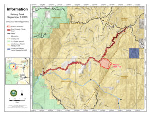
September 6, 2025
LOWER ROGUE RIVER CORRIDOR, Ore. (Sept. 6, 2025) – Challenging conditions once again were felt by resources assigned to the Kelsey Peak Fire, burning on Bureau of Land Management (BLM) land along the Lower Rogue River Corridor roughly 26 miles northwest of Grants Pass. Smoky conditions persisted across the fire today, contributing to lower intensity fire behavior, but shutting down air operations for a second day in a row. Despite the lack of air support, firefighters were able to hold the established lines and even build on some of them today, bolstering their overall strength. Storm systems moving through the area could bring erratic winds tonight, which could naturally increase fire behavior; firefighters working the evening shift are prepared for this possibility. Resources include five 20-person crews, 13 engines, two water tenders and medical personnel.
With the complexities of the topography, steep terrain, and dense brush, as well as thunderstorms in the forecast for the coming days bringing added threats of new fire starts, the decision was made by the Oregon Department of Forestry (ODF) Southwest Oregon District and BLM Medford District to order ODF Complex Incident Management Team (CIMT) 1. The team will bring added resources to the fire, as well as release local ODF personnel to return to their normal initial attack response readiness in the face of potential new fire starts. The team will arrive on Sunday afternoon and be in-briefed with the current fire situation before taking command of the incident Monday morning.
This afternoon, the Josephine County Sheriff’s Office and Emergency Management placed Zone JCU-801, located mostly southeast of the fire, on a Level 1, BE READY evacuation notice. Additionally, BLM Grants Pass Field Office has temporarily closed a portion of the Grave Creek to Marial Backcountry Byway (BLM Road 32-9-14.2) and Sheriff John Ward of the Curry County Sheriff’s Office issued a Level 3, GO NOW, evacuation order for the area of Rogue River Ranch, Tucker Flat Campground and the nearby area of Marial. The public is strongly encouraged to avoid the entire Byway to facilitate safe firefighter access on the steep, narrow, windy road. Members of the public may not enter closed areas, and all uses—including hiking, hunting and dispersed camping—are prohibited. Please see the map for full closure information on the BLM website: https://www.blm.gov/programs/public-safety-and-fire/fire-and-aviation/regional-info/oregon-washington/fire-restrictions
Thunderstorms began to materialize around 5 p.m. in southern Oregon. Numerous cloud-to-ground lightning strikes have been recorded up the entire west side of Jackson County with a small cluster in southeastern Josephine County at the time of this release. While the system brought some rain, firefighters are ready to respond to new reports of fire tonight. ODF’s Detection Center staff are monitoring these strike areas for smoke and a reconnaissance flight is planned for this evening with more flights planned for Sunday morning.
The fires along the Lower Rogue River Corridor were started by lightning during a thunderstorm last Wednesday; the following is a complete list of the fires that affected ODF-protected land:
| Fire |
Size (Acres) |
Status |
| August Knob Fire |
1/100 |
100% lined, 100% mopped up |
| Bald Ridge Fire |
— |
Unable to locate (UTL) |
| Bald Ridge Fire #2 |
1/4 |
100% lined, 100% mopped up |
| Big Meadow Fire |
1/10 |
100% lined, 100% mopped up |
| Cold Springs Fire |
1/10 |
100% lined, 100% mopped up |
| Ditch Creek Fire |
1/10 |
100% lined, 100% mopped up |
| Hewitt Creek Fire |
1/10 |
Turned over to USFS |
| Jeep Ridge Fire |
1/100 |
100% lined, 100% mopped up |
| Kelsey Peak Fire |
506 |
25% lined, 0% mopped up |
| Marial Fire |
1/2 |
100% lined, 100% mopped up |
| Mule Creek Fire |
2 |
100% lined, 100% mopped up |
| Quail Creek Fire |
1/10 |
100% lined, 100% mopped up |
Additional fires burning downriver near the Paradise and Half Moon Bar Lodges are on ground protected by our partners at the U.S. Forest Service Rogue River-Siskiyou National Forest and the Coos Forest Protective Association; please follow their pages for additional fire updates.
Help firefighters by following all current regulations during Extreme fire danger:
September 6, 2025
LOWER ROGUE RIVER CORRIDOR, Ore. (Sept. 6, 2025) – Firefighters continued to engage aggressively on the Kelsey Peak and Marial fires burning along the Lower Rogue River Corridor last night, located roughly 26 miles northwest of Grants Pass. These fires are two of 10 that started as a result of lightning on ODF Southwest Oregon District-protected land following thunderstorms on Wednesday. Overnight, resources were able to finish work on the Marial Fire, stopping it at a half-acre and mopping up 100% of the incident. This leaves the Kelsey Peak Fire as the only active incident of 10 fires affecting Bureau of Land Management (BLM) land. While the other nine are in patrol status, they continue to be monitored for signs of heat and any lingering hot spots found are immediately extinguished.
Fire behavior remained active on the Kelsey Fire overnight, but resources were able to put in line with bulldozers, connecting to the work that was completed yesterday along BLM Road 32-9-14 on the north end of the fire. They were also able to reinforce those lines along the road itself and hold the fire there despite embers that threatened to spread beyond established control lines.
Today, this work will continue. Resources assigned to the fire for Saturday include 11 20-person crews, two 10-person crews, 14 engines, two sets of fallers, five bulldozers, and seven water tenders, along with three Type 1, three Type 2 and two Type 3 helicopters; in all, 326 personnel are working on the fire today. Smoky conditions didn’t allow for the use of aircraft yesterday, however clearer skies this morning may mean work from the sky can continue safely today. Additional resources like air tankers will be ordered as needed.
Overnight, an infrared (IR) flight was able to be conducted over the Kelsey Peak Fire, and through more arcuate mapping, the fire was determined to be 506 acres. This jump in acreage is partly due to strategic firing operations that were conducted yesterday to protect the BLM Road 32-9-14.2, which serves as the only exit for communities further west of the fire. ODF, BLM and firefighters on the ground remain committed to keeping this fire as small as possible and extinguishing it quickly, but safely. Challenges on this fire include incredibly steep terrain, limited road access, dense brush, large hazardous trees, rolling debris and snakes.
Due to the threatened road, the BLM Grants Pass Field Office has temporarily closed a portion of the Grave Creek to Marial Backcountry Byway (BLM Road 32-9-14.2) and Sheriff John Ward of the Curry County Sheriff’s Office issued a Level 3, GO NOW, evacuation order for the area of Rogue River Ranch, Tucker Flat Campground and the nearby area of Marial. The public is strongly encouraged to avoid the entire Byway to facilitate safe firefighter access on the steep, narrow, windy road. Members of the public may not enter closed areas, and all uses—including hiking, hunting and dispersed camping—are prohibited. The closure order encompasses BLM Road 32-9-14.2 along the Grave Creek to Marial Backcountry Byway. Please see the map for full closure information on the BLM website: https://www.blm.gov/programs/public-safety-and-fire/fire-and-aviation/regional-info/oregon-washington/fire-restrictions
The following is a complete list of fires on ODF-protected land from Wednesday’s thunderstorm:
| Fire |
Size (Acres) |
Status |
| August Knob Fire |
1/100 |
100% lined, 100% mopped up |
| Bald Ridge Fire |
— |
Unable to locate (UTL) |
| Bald Ridge Fire #2 |
1/4 |
100% lined, 100% mopped up |
| Big Meadow Fire |
1/10 |
100% lined, 100% mopped up |
| Cold Springs Fire |
1/10 |
100% lined, 100% mopped up |
| Ditch Creek Fire |
1/10 |
100% lined, 100% mopped up |
| Hewitt Creek Fire |
1/10 |
Turned over to USFS |
| Jeep Ridge Fire |
1/100 |
100% lined, 100% mopped up |
| Kelsey Peak Fire |
506 |
25% lined, 0% mopped up |
| Marial Fire |
1/2 |
100% lined, 100% mopped up |
| Mule Creek Fire |
2 |
100% lined, 100% mopped up |
| Quail Creek Fire |
1/10 |
100% lined, 100% mopped up |
Thunderstorms remain in the forecast, but the risk has been heightened today. As a result, the National Weather Service Medford Office has issued a Red Flag Warning from 2 – 11 p.m. across all of Jackson and Josephine counties, and the most western portion of Curry County where the Kelsey Peak Fire is located. The designation is due to the potential for abundant lightning on dry fuel with gusty, erratic winds up to 35 miles per hour. While storms could bring rain, windy conditions can prompt fire growth and lightning can bring new fire starts. Firefighters across the district remain ready to respond to new reports of fire and detection flights over existing or new lightning strikes will be conducted as needed.
Additional fires burning downriver near the Paradise and Half Moon Bar Lodges are on ground protected by our partners at the U.S. Forest Service Rogue River-Siskiyou National Forest and the Coos Forest Protective Association; please follow their pages for additional fire updates.
Help firefighters by following all current regulations during Extreme fire danger:
September 5, 2025
LOWER ROGUE RIVER CORRIDOR, Ore. (Sept. 5, 2025) – Resources on the Kelsey Peak, Mule Creek and Marial fires burning along the Lower Rogue River Corridor located roughly 26 miles northwest of Grants Pass continued to push forward on progress today. Dayshift crews picked up where nightshift firefighters left off, constructing hose around the fire’s perimeter to allow for water access. Firefighters were also able to fully mop up the Mule Creek Fire and complete 90% of mop-up operations on the Marial Fire today. These fires are a result of lightning that struck in the area during thunderstorms on Wednesday afternoon, affecting Bureau of Land Management (BLM) land.
The Kelsey Peak Fire remains the largest of the incidents by far, estimated to have grown to 120 acres following an active day. Hot, windy temperatures fueled fire growth on the north and northwest sides of the fire, prompting firefighters to use strategic firing operations to protect roads in the area and build a stronger defense against the fire’s observed growth potential.
Due to the threatened roadway, Sheriff John Ward of the Curry County Sheriff’s Office issued a Level 3, GO NOW, evacuation order for the area of Rogue River Ranch and the nearby area of Marial on the BLM Road 32-9-14.2 Road. While the structures in these areas weren’t directly threatened, the road serves as the only way out of those areas. ODF personnel working the fires conducted in-person evacuation warnings to Rogue River Ranch, Tucker Flat Campground and Marial due to what would have been a long response time to the remote area from available county personnel.
In conjunction with the evacuations, the Bureau of Land Management Grants Pass Field Office has temporarily closed a portion of the Grave Creek to Marial Backcountry Byway near the Rogue River Ranch for firefighter and public safety. The public is strongly encouraged to avoid the entire Byway to facilitate safe firefighter access on the steep, narrow, windy road. Members of the public may not enter closed areas, and all uses—including hiking, hunting and dispersed camping—are prohibited. The closure order encompasses BLM Road 32-9-14.2 along the Grave Creek to Marial Backcountry Byway. Please see the map for full closure information on the BLM website: https://www.blm.gov/programs/public-safety-and-fire/fire-and-aviation/regional-info/oregon-washington/fire-restrictions
Tonight, more than 150 personnel will be working the fires, including five 20-person crews, 13 engines, three water tenders and overhead.
The following is a complete list of fires on ODF-protected land from Wednesday’s thunderstorm:
| Fire |
Size (Acres) |
Status |
| August Knob Fire |
1/100 |
100% lined, 100% mopped up |
| Bald Ridge Fire |
— |
Unable to locate (UTL) |
| Bald Ridge Fire #2 |
1/4 |
100% lined, 100% mopped up |
| Big Meadow Fire |
1/10 |
100% lined, 100% mopped up |
| Cold Springs Fire |
1/10 |
100% lined, 100% mopped up |
| Ditch Creek Fire |
1/10 |
100% lined, 100% mopped up |
| Hewitt Creek Fire |
1/10 |
Turned over to USFS |
| Jeep Ridge Fire |
1/100 |
100% lined, 100% mopped up |
| Kelsey Peak Fire |
120 (estimated) |
25% lined, 0% mopped up |
| Marial Fire |
1/2 |
100% lined, 90% mopped up |
| Mule Creek Fire |
2 |
100% lined, 100% mopped up |
| Quail Creek Fire |
1/10 |
100% lined, 100% mopped up |
Additional fires burning downriver near the Paradise and Half Moon Bar Lodges are on ground protected by our partners at the U.S. Forest Service Rogue River-Siskiyou National Forest and the Coos Forest Protective Association; please follow their pages for additional fire updates.
Help firefighters by following all current regulations during Extreme fire danger:
September 5, 2025
LOWER ROGUE RIVER CORRIDOR, Ore. (Sept. 5, 2025) – Firefighters assigned to multiple fires along the Lower Rogue River Corridor in northwestern Josephine County overnight made great progress on the smaller incidents and held the Kelsey Peak Fire in its current footprint. Cooler temperatures allowed resources to line and mop up an additional three fires, bringing the total numbers of fires already extinguished to seven. This work only leaves the Kelsey Peak, Marial and Mule fires still in an active status. Today, firefighters assigned to these incidents will continue to build on this progress.
The Kelsey Peak Fire remains the largest incident. Overnight, minimal growth was seen and the fire remains an estimated 80 acres. Resources worked early into Friday morning, holding the lines built, strengthening them where possible, and bringing in miles of hose. Firefighters working Friday’s day shift will distribute this hose across the fire and build a system to allow water access across the incident. Firefighters will also continue to build line and use aircraft where needed.
Today, resources assigned to these incidents include four 20-person crews, two 10-person crews, four engines, two bulldozers, two water tenders and various aircraft, including three Type 1, three Type 2 and two Type 3 helicopters. Air tankers will be ordered as needed, and if possible, due to smoky conditions. More than 130 personnel are currently assigned to these fires, with the majority dedicated to the Kelsey Peak Fire.
The following is a complete list of fires on ODF-protected land from Wednesday’s thunderstorm:
| Fire |
Size (Acres) |
Status |
| August Knob Fire |
1/100 |
100% lined, 100% mopped up |
| Bald Ridge Fire |
— |
Unable to locate (UTL) |
| Bald Ridge Fire #2 |
1/4 |
100% lined, 100% mopped up |
| Big Meadow Fire |
1/10 |
100% lined, 100% mopped up |
| Cold Springs Fire |
1/10 |
100% lined, 100% mopped up |
| Ditch Creek Fire |
1/10 |
100% lined, 100% mopped up |
| Hewitt Creek Fire |
1/10 |
Turned over to USFS |
| Jeep Ridge Fire |
1/100 |
100% lined, 100% mopped up |
| Kelsey Peak Fire |
80 (estimated) |
25% lined, 0% mopped up |
| Marial Fire |
1/2 |
100% lined, 20% mopped up |
| Mule Creek Fire |
1 |
100% lined, 25% mopped up |
| Quail Creek Fire |
1/10 |
100% lined, 100% mopped up |
With numerous fires along the lower Rogue River Corridor, please avoid these areas for your safety and the safety of those responding to these incidents. Road closures to the Rogue River Ranch, adjacent to the fire will likely be going into effect today. Additional fires burning downriver near the Paradise and Half Moon Bar Lodges are on ground protected by our partners at the U.S. Forest Service Rogue River-Siskiyou National Forest and the Coos Forest Protective Association; please follow their pages for additional fire updates.
Thunderstorms remain in the forecast for today and tonight across Jackson and Josephine counties, with higher probability for the eastern portion of Jackson County. As a result, the National Weather Service Medford office has issued a Red Flag Warning today from 1 – 9 p.m. across eastern Jackson County for abundant lightning on dry fuels. These storms bring the potential for gusty wind on existing incidents and new fire starts from lightning. Rain over the fire area is also a possibility today.
ODF fire regulations are available here: https://swofire.com/public-fire-restrictions/.
BLM fire regulations can be found here: https://www.blm.gov/programs/fire/fire-restrictions
September 4, 2025
LOWER ROGUE RIVER CORRIDOR, Ore. (Sept. 4, 2025) – Firefighters continued an aggressive, relentless attack on numerous fires throughout the Lower Rogue River Corridor in northwestern Josephine County on Thursday. These fires, a result of lightning strikes from Wednesday afternoon’s thunderstorm, are affecting Bureau of Land Management (BLM) land approximately 26 miles northwest of Grants Pass near the Winkle Bar Airstrip:
- The Kelsey Peak Fire remains the largest incident, now estimated to be 80 acres tonight. This fire is now the number one priority fire across ODF’s statewide jurisdiction due to its difficulty and safety concerns, and that designation will help to bring in more aircraft and needed resources. Firefighters were able to make good progress on a lot of the fire, building line where possible on the north and east sides of the incident; It’s currently 25% lined. The southern portion of the fire’s perimeter saw the most growth, and steep terrain and dense brush made working in this area difficult and dangerous. Aircraft were used throughout the day to drop water where needed, and an air tanker was able to drop a retardant line along the eastern border, which is serving as a temporary line as well. More air tankers were ordered, however smoky conditions around the fire made a retardant drop unsafe for a tanker to fly that low to the ground again. All resources continue to hike the hour and half trek to reach this fire, or return back to the road after a full shift.
- The Bald Ridge Fire #2 was located and caught at a quarter-acre last night. Firefighters were able to complete mop-up operations on this incident today, leaving it 100% lined and mopped up.
- The Cold Springs Fire was caught overnight at 1/10 of an acre last night. Firefighters were on scene today to finish mop-up following extensive saw work.
- The Ditch Creek was located by firefighters today, and they were able to stop this fire at 1/10 of an acre. It’s currently 100% lined and mop-up operations are ongoing. This fire is the only incident on private land.
- The Marial Fire was located by firefighters today and is currently holding at half an acre. Resources on scene remain engaged and working to build a line around it.
- The Mule Creek is estimated to be one acre. Resources were engaged on this incident today and will continue work tonight.
- The Bald Ridge Fire has not been located. Firefighters will continue to look for signs of fire in this area, as it may flare up again.
- The Hewitt Creek Fire was turned over to the U.S. Forest Service.
Firefighters also located four new lightning-caused fires today:
- The August Knob Fire, located northwest of the Kelsey Peak Fire. It’s currently 1/100 of an acre and firefighters are engaged.
- The Quail Creek Fire, just southwest of the August Knob Fire, was stopped at 1/10 of an acre today. It’s currently 100% lined and mop-up operations have begun.
- The Big Meadow Fire, located near the Quail Creek incident, was found and stopped at 1/10 of an acre today. It’s 100% lined and mopped up tonight.
- The Jeep Ridge Fire, located closer to the Kelsey Peak Fire, is 100% lined and 30% mopped up. It was caught at 1/100 of an acre today.
Tonight, a number of resources have been ordered to work Thursday’s overnight shift, including five 20-person crews, 13 engines and three water tenders. More than 120 personnel are assigned to these incidents tonight, with additional resources that are set to relieve them in the morning.
Additional fires burning in these areas are on ground protected by our partners at the U.S. Forest Service Rogue River-Siskiyou National Forest and the Coos Forest Protective Association; please follow their pages for additional fire updates. With numerous fires along the lower Rogue River Corridor, please avoid these areas if at all possible, for your safety and the safety of those responding to these incidents. Road closures adjacent to the fire are in the works and will be going into effect for public and firefighter safety tomorrow.
Thunderstorms continue to remain in the forecast for tonight and tomorrow across Jackson and Josephine counties, with higher probability for the eastern portion of Jackson County. As a result, the National Weather Service Medford office has issued a Red Flag Warning for Friday from 1 – 9 p.m. across eastern Jackson County for abundant lightning on dry fuels. These storms bring the potential for gusty wind on existing incidents and new fire starts from lightning.
Today, firefighters also responded to a fire on the 3000-block of Jump Off Joe Creek Road around 9 a.m. this morning. Firefighters were able to stop that fire at 1/10 of an acre and tonight, it’s 100% lined and mopped up. As firefighters work to stop these fires on the Lower Rogue River Corridor, help them by preventing new fire starts on our landscape. Extreme fire danger is currently in effect on ODF and BLM land in Jackson and Josephine counties; all ODF regulations are available here: https://swofire.com/public-fire-restrictions/. BLM fire regulations can be found here: https://www.blm.gov/programs/fire/fire-restrictions
For fire updates anytime, follow ODF Southwest Oregon District on Facebook @ODFSouthwest or on our website, swofire.com.
September 4, 2025
LOWER ROGUE RIVER CORRIDOR, Ore. (Sept. 4, 2025) – The Oregon Department of Forestry (ODF) Southwest Oregon District is continuing to put up an aggressive attack on fires spanning the Lower Rogue River Corridor in northwestern Josephine County following thunderstorms that moved through the area Wednesday afternoon. In all, eight fires were initially reported by a reconnaissance flight on Wednesday evening, and resources were immediately dispatched to each incident. All but one are affecting Bureau of Land Management (BLM) land:
- The Kelsey Peak Fire is currently the largest fire, estimated to be 20 and 30 acres this morning. There is no easy road access to this fire; it requires an hour and a half hike to reach it. Steep terrain is creating safety and logistical challenges for firefighters, and crews on the line witnessed a notable increase in fire behavior early this morning with tree torching and spot fires reported. This fire will be a priority for firefighters and aircraft today.
- The Bald Ridge Fire #2 was located and caught at a quarter-acre overnight. It’s currently 100% lined and 45% mopped up. Resources will work to further mop-up operations today.
- The Cold Springs Fire was caught overnight at 1/10 of an acre. Firefighters have lined and mopped up 25% of the incident and spent the rest of the evening doing extensive saw work.
- The Marial, Mule Creek, Ditch Creek, and Bald Ridge fires were all estimated to be between 1/100 and 1/10 of an acre by our recon flight last night. Firefighters spent hours hiking in these areas to find the best access, but couldn’t locate them due to steep slopes, heavy brush and vegetation, and dark conditions. Recon flights this morning will check on these fires and help guide firefighters to them if they’re visible.
- The Hewitt Creek Fire is likely on U.S. Forest Service land. Firefighters hiked around in the area but couldn’t locate the fire last night. Assistance to our partners on this incident will be provided as available today.
“Some of the toughest ground in the nation to fight fire on is in the Lower Rogue Corridor,” ODF Southwest Oregon District Forester Dan Quinones said. “With one fire reaching 20 to 30 acres overnight, that fire behavior will only pick up in the heat. We’re getting a move on this; the battle won’t get any easier than it is right now.”
Additional fires burning in these areas are on ground protected by our partners at the U.S. Forest Service Rogue River-Siskiyou National Forest and the Coos Forest Protective Association; please follow their pages for additional fire updates. Collectively as a firefighting system, our continued goal is to keep all fires as small as possible and extinguish them as fast as we can.
Numerous resource orders have been made for today and tonight’s shift, however other large-scale fires across the state are creating challenges in filling every order. Today, two 20-person crews, four engines, two sets of fallers, one water tender, a Rapid Extraction Module (REMs) medical unit and overhead will be assigned to these incidents. Aircraft assigned currently includes four helicopters: one Type 1, two Type 2 and one Type 3. Other orders have been made and not yet filled. Resource orders will continue to be made for what’s needed on the ground despite these challenges and firefighters will strategically use what’s available.
Thunderstorms continue to remain in the forecast for today, bringing the potential for gusty wind on existing incidents and new fire starts from lightning. Extreme fire danger is currently in effect on ODF-protected land in Jackson and Josephine counties; as firefighters work to extinguish these natural fire starts, help prevent new human-caused fires from sparking by following all regulations currently in place: https://swofire.com/public-fire-restrictions/. For fire information anytime, visit ODF’s Facebook page, @ODFSouthwest or website, www.swofire.com. BLM fire regulations can be found here: https://www.blm.gov/programs/fire/fire-restrictions

August 10, 2025
JACKSON & JOSEPHINE COUNTIES, Ore. (August 10, 2025) – Due to dry vegetation, fire behavior, and consistent hot and windy conditions, the fire danger level on lands protected by the Oregon Department of Forestry in Jackson and Josephine counties will increase to “extreme” (red) at 12:01 a.m. on Tuesday, August 12, 2025. These regulations impact 1.8 million acres of state, private, county, city and Bureau of Land Management lands protected by ODF’s Southwest Oregon District. The Industrial Fire Precaution Level (IFPL) will remain at two (2).
Beginning Tuesday morning at 12:01 a.m., the following public fire restrictions will take effect:
- The use of power saws is prohibited, excluding electric chainsaws.
- The cutting, grinding and welding of metal is prohibited.
- The mowing of dry or dead grass is prohibited. This includes lawnmowers, weed eaters, and any other type of grass-trimming equipment. The mowing of green lawns is allowed at any time.
- The operation of any other spark-emitting internal combustion engine not specifically mentioned above is prohibited.
The following fire prevention regulations are currently in effect and will remain in effect until the fire danger level drops significantly:
- Debris burning, including the use of burn barrels, is prohibited.
- Open fires are prohibited, including campfires, charcoal fires, cooking fires and warming fires, except in approved fire rings at designated campgrounds. In other locations clear of dry vegetation, portable cooking stoves using liquefied or bottled fuels are allowed.
- Smoking is prohibited while traveling, except in vehicles on improved roads, in boats on the water, and designated locations.
- Fireworks on or within 1/8th of a mile of ODF-protected land are prohibited. Fireworks are also prohibited on all BLM lands.
- Any electric fence controller in use shall be listed by a nationally recognized testing laboratory or be certified by the Department of Consumer and Business Services; and operated in compliance with the manufacturer’s fire-safe instructions.
- The use of exploding targets is prohibited.
- The use of tracer ammunition or any bullet with a pyrotechnic charge in its base is prohibited.
- Motor vehicles, including motorcycles and all-terrain vehicles, may only be used on improved roads free of flammable vegetation, except when used for the commercial culture and harvest of agricultural crops.
- Possession of the following firefighting equipment is required while traveling, except on state highways, county roads and driveways: one shovel and one gallon of water or one 2.5 pound or larger fire extinguisher. All-terrain vehicles and motorcycles must be equipped with one 2.5 pound or larger fire extinguisher.
The National Weather Service has issued an Extreme Heat Warning across southern Oregon, in effect now through Wednesday at 2 a.m. due to triple digit temperatures up to 110 degrees. These conditions, in combination with dry vegetation, naturally promote fire growth. Be aware of the increased risk and prevent fires by following the current regulations, found here: https://swofire.com/public-fire-restrictions. For more information about the Oregon Department of Forestry Southwest Oregon District’s fire season regulations, visit our website, www.swofire.com or our Facebook page @ODF Southwest Oregon District.
July 26, 2025
ANDERSON BUTTE, Ore. (July 26, 2025) – Oregon Department of Forestry (ODF) Southwest Oregon District firefighters have stopped a fire at just under six acres, originally reported early Saturday morning. The Anderson Butte Fire, located off of Anderson Butte Road west of Ashland and east of Buncom, is now fully lined and 90% mopped up, with work almost complete across the entire incident despite warm conditions, dry grass and steep slopes.
Just after midnight, ODF received a report of a fire on Anderson Butte Road. Upon arrival, resources found an estimated five-acre grassfire, burning on a steep slope through grass and brush. Firefighters worked quickly to line the fire with water, slowing its spread. This allowed resources to reinforce the line by hand, digging down to the bare dirt and holding it at an estimated six acres. Firefighters spent Saturday morning extinguishing flames and hotspots, keeping the fire out of trees and contained to its small footprint. By noon, the fire was fully lined and 60% mopped up, with this work nearing completion by 2:00 p.m.
The cause of the fire is under investigation. Hot temperatures continue to dry out vegetation, steadily increasing the risk of fires starting and spreading; the majority of fires are human-caused and accidental, largely started by the activities that are regulated by ODF during fire season. Help prevent new fires from starting by following all current regulations, found here: https://swofire.com/public-fire-restrictions.
This will be the only update on this incident. Fire season information is always available online on our Facebook page, @ODFSouthwest and our website, www.swofire.com.
July 25, 2025
GRANTS PASS, Ore. (July 25, 2025) – Firefighters assigned to the Board Shanty Fire, located south of Grants Pass, continue to make steady progress across the incident, extinguishing lingering coals and smoking debris. With this work ongoing during both day and night shifts, containment has now increased to 45% on the 469-acre fire. Due to the progress and current status of the incident, the local Type 3 team that has been in command of the fire will transition to a smaller local Type 4 organization to complete the rest of the work beginning Saturday morning.
Currently, there are 183 personnel assigned to the Board Shanty Fire, with 115 working during the day and the remainder assigned to the night shift. These resources will continue mop-up work, building depth on the line to the point where 300 feet into the interior of the fire is free of heat or smoke. As this work is completed and the line is strengthened, containment will continue to increase.
Aircraft is available today if needed, and a reconnaissance flight is scheduled for 2 p.m. to search for any visible smoke over the fire and direct ground crews where needed. A Temporary Flight Restriction (TFR) is in place over the fire area to create a safe airspace for fire-related aircraft when needed. As a reminder, flying drones over or near a fire is illegal and incredibly dangerous to working aircraft; if you fly, we can’t.
On Thursday evening, the Josephine County Sheriff’s Office and Emergency Management canceled all remaining Level 1 – Be Ready evacuation notices for Zones JCU-436, JCU-437 and JCU-448-A. To learn your zone, visit: https://protect.genasys.com and enter your address in the search bar.
The cause of the fire remains under investigation. This will be the final update on this incident unless conditions significantly change. Help prevent new human-caused fires from sparking by following all regulations currently in place: