September 19, 2020
Weather conditions have improved across ODF’s Southwest Oregon District and the Industrial Fire Precaution Level (IFPL) has returned to level 3 as of Friday, Sept. 18 at 9:00 a.m. At this time the district will not be issuing any IFPL or PDM waivers. The district asks landowners and operators to continue to use extreme caution and monitor weather conditions closely.
September 18, 2020
Update for Sept. 18, 2020
Southern Area Red Team, Incident Commander Mike Dueitt
Email: 2020.archiecreek@firenet.gov
Phone: 971-334-7674 Hours: 7am-8pm
InciWeb: https://inciweb.nwcg.gov/incident/7176/
Facebook: https://www.facebook.com/Archie-Creek-Fire-Information-120244459815292/
Special Note: Fire personnel will hold a virtual public meeting about the Archie Creek Fire via Zoom tonight at 7:00 p.m. To join, go to: https://usfs.zoomgov.com/j/1617467845?pwd=d211WXp4a3ZXMTdyQjJwRE5zQ0NYZz09
Fire Update: The Archie Creek Fire has burned 130,429 acres and is 25% contained. There are currently 1,094 personnel assigned to the fire. Yesterday the Southern Area Red Type 1 Incident Management Team with Incident Commander Mike Dueitt shadowed the Northwest Incident Management Team 9 with Incident Commander Brian Goff. Today Team 9 transferred management of the fire to the Red Team, who joins in Unified Command with the Douglas Forest Protective Association, Bureau of Land Management and USDA Forest Service. The Red Team thanks Team 9 for a smooth transition and looks forward to serving the communities affected by this devastating wildfire.
The fire was most active yesterday on the south, east and northern edges and these will be areas of focus today. In the south, fire backed down slopes to Little River Road. Firefighters monitored this area and kept the fire from crossing the road. In the east, fire slopped over containment lines on the 4714 (Panther Creek) Road in three places. Firefighters contained two of these areas and will work to contain the third area today. Along the northeastern edge of the fire, operators of bulldozers and logging equipment are working to connect old logging roads for firelines to protect threats to timber sales.
Fire mop up and improvement of firelines continues throughout the fire, including mop up around structures in Glide and Idleyld Park. Recent rain and humid air is allowing firefighters and heavy equipment to work closer to the fire’s edge to contain it. Improvement of firelines continues along the 2500 road system at the northern edge of the fire at the upper drainages of Rock Creek, along the 600 road series at the southeast side of the fire, where bulldozers and masticators are working and in the Hinkle Creek area at the northwest side of the fire.
Firefighters continue to take actions to keep the fire from spreading to structures. They are protecting structures from fire in all areas of the fire, including along Little River Road. Yesterday good progress was made in protecting Wolf Creek Job Corps at the southern edge of the fire. Work continues to open Rock Creek access roads to Scott Mountain to protect communication equipment there.
North of Highway 138E, in the Steamboat area, firefighters and heavy equipment continue to work along Canton Creek Road to Trapper Creek to build contingency firelines in case the fire crosses primary firelines.
Helicopters and airplanes were unable to fly again yesterday due to the thick smoke. Four helicopters are available for use when the smoke clears.
A low pressure system brought rain to the fire area yesterday, with a wetting rain on the western side of the fire. More rain is expected this afternoon, with at least 0.25 inches is expected to fall on the fire area through Friday night. The area has not seen wetting rain since June. With a chance of thunderstorms and hail this afternoon into the evening, firefighters will be vigilant for severe weather and possible debris flows. The rain will again help moderate fire behavior, but live and dead vegetation will dry out quickly once the low pressure system passes.
Highway 138E remains closed to all non-fire traffic from Milepost 21 through Milepost 83. Crews from the Oregon Department of Transportation, Douglas County Public Works Department, Pacific Power and their contractors continue to work along Highway 138E, Rock Creek Road and other county-maintained roads within the footprint of the fire.
Archie Creek Fire Donations: At this time, the Archie Creek Fire management team does not need donations. To help firefighters and their families, please contact the Wildland Firefighters Foundation at wffoundation.org/or 208-336-2996.
The following agencies and organizations are helping those who were affected by this fire and are accepting donations.
https://www.paypal.com/cgi-bin/webscr?cmd=s-xclick&hosted_button_id=3D2BEGT2AJBRS&source=url
- Douglas Timber Operators / Umpqua Fisheries Enhancement Derby:
https://donorbox.org/2020-archie-creek-fire-relief-fund
- Saving Grace: savinggrace.info 541-672-3907.
- Red Cross: Located at the Douglas County Fairgrounds. Check for current needs.
- Oregon Department of Human Services: Check for current needs. Food items will not be accepted. Donations can be dropped off this week at the Roseburg Department of Human Services building at 738 W Harvard, Roseburg OR M-F, 9am-4pm through 9/18/20
Evacuations, shelter areas: An interactive map of the current evacuation area can be found at www.dcso.com/evacuations. For more evacuation information, visit the Douglas County Sheriff website www.dcso.com/evacuations and Facebook page at https://www.facebook.com/DouglasCoSO
The Red Cross has services and a shelter at the Douglas County Fairgrounds. Call 541-672-6581 The Western Oregon Expo Fairgrounds in Cottage Grove has space for evacuees, livestock and tents. Contact Skye Hefner at 541-556-2727 for more information.
Air quality: See the Oregon Department of Environmental Quality at http://www.oregon.gov/deq
Closures:
- Roads – Highway 138E remains closed to all non-fire traffic from Milepost 21 through Milepost 83. Monitor tripcheck.com for updates on the highway closures.
- Bureau of Land Management – All lands east of Interstate 5, within the Swiftwater Resource Area are closed.
- Umpqua National Forest – Maps and closure orders can be found on Inciweb at: https://inciweb.nwcg.gov/incident/closures/7176/. Additional information on the Forest Service closures are available at: https://www.fs.usda.gov/alerts/umpqua/alerts-notices Managed lands east of Interstate 5, within the Swiftwater Resource Area are closed.
- Temporary Flight Restriction: There is a temporary flight restriction in effect for the Archie Creek Fire.
September 18, 2020
Update for Sept. 18, 2020, 1:30 p.m.
Incident Commander: Southern Area Incident Management Gold Team
Fire Information Line: 541-595-8227
Acres: 9,995
Containment: 15%
Location: Diamond Lake Ranger District, Umpqua National Forest, about 5 miles north of Crater Lake National Park and within 1 mile of Diamond Lake Resort.
Evacuations: Level 3 “GO” evacuations are in place for the Diamond Lake, Lemolo Lake and Toketee Ranger Station areas. Visit the
Douglas County Sheriff’s website for the most current information.
Location
5 miles north of Crater Lake National Park and within 1 mile of Diamond Lake Resort
Resources
Total Personnel: 329 Helicopter: 1 Type 3 Engines: 4 Type 4 Engines: 5
Type 6 Engines: 7 Dozers: 6 Water Tenders: 5 Masticators: 1
Current Situation
Today, firefighters will focus on direct attack where possible, as well as protecting critical infrastructure and securing and holding the fire’s southern edge near the northern boundary of Diamond Lake. They will also secure and mop up along containment lines. Crews will secure the Cinnamon Butte communications tower and improve structure defense around the tower. Air operations will drop retardant to protect the Cinnamon Butte Lookout as weather conditions allow. Firefighters will use heavy equipment to create lines around the fire and will conduct firing operations when fire behavior and weather permits.
Closures
Road Closures: Highway 138E is closed. For the latest road conditions, visit www.tripcheck.com.
Forest Closures: Temporary emergency closure orders are in effect for all National Forest System lands, roads, and trails within the Cottage Grove Ranger District: ORDER NO. 06-15-01-20-423, Tiller Ranger District ORDER NO. 06-15-02-20-422, Diamond Lake Ranger District ORDER NO. 06-15-03-20-420 and North Umpqua Ranger District ORDER NO. 06-15-06-20-421.
Flight restrictions: A temporary flight restriction is in place from the surface up to and including 10,000 feet to provide a safe environment for fire-fighting aviation operations.
Air Quality
Areas around the Thielsen Fire should start to see clearing this morning. For more information visit http://oregonsmoke.blogspot.com/
Weather and Fire Behavior
Temperatures will be lower today with higher humidity. Forecasted precipitation should stall fire behavior. Thunderstorm development could produce outflow gusts of 50 mph. Over the next couple of days, warmer and drier conditions will gradually return, potentially causing increased fire behavior.
September 18, 2020
Update for Sept. 18, 2020, 10:15 a.m.
Oregon Department of Forestry IMT 3 Link Smith, Incident Commander and Oregon State Fire Marshal’s Red Team Ian Yocum, Incident Commander
Holiday Farm Fire Information: 541-357-9729 (7am-10pm)
Lane County Non-Emergency Call Center: 541-682-3977 (7am-10pm)
Linn County Non-Emergency Call Center: 541-812-2260
Facebook: https://www.facebook.com/HolidayFarmFire/
Email: holidayfarmfireinfo@gmail.com
Springfield, Ore. –Infrared flight mapping was unavailable again last night, the Holiday Farm Fire’s footprint is currently estimated at 172,510 acres and containment remains at 10%. The fire’s perimeter measures more than 260 miles.
A tree faller was injured by a fallen limb while working to clear roads within the fire area. He was transported to the hospital by ambulance for evaluation and treatment. His injuries do not appear to be life threatening.
Friday’s weather-An upper low will move across the fire area today and bring showers. The weather forecast continues to predict possible afternoon thunder storms with gusty erratic winds and small hail. Showers continue tonight and into Saturday but will gradually diminish.
Wildland fire crews will continue working to improve and increase fire containment using hand crews, fire engines and heavy machinery. Crews will be taking advantage of the wet weather to clear roads in the Quartz Creek area and will continue to focus along Hwy 126. Yesterday crews found and addressed a ten-acre spot fire.
Structural firefighters continue to work along Hwy 126 from Leaburg to Rainbow patrolling and clearing defensible space around houses. As conditions improve in and around buildings the need for structural resources is decreasing. This will allow these resources to return to protecting their home communities.
The Urban Search and Rescue Team will be entirely working west of Nimrod. They have completed 1,273 structural evaluations in the fire area. Structures include commercial buildings, residences and outbuildings. The US&R team is hoping to finish their work today and will be released when their mission is complete.
The Lane and Linn County Sheriff’s Offices continue to work with fire operations personnel to modify evacuation zones where appropriate. For the latest information on evacuation areas, please visit:
Lane County: www.lanecounty.org/mckenziefire
Linn County: www.linnsheriff.org/fire_live_updates_sept_2020/
Please continue to monitor cell phones, landlines, local media and official information sources for evacuation updates. Fire managers request that the public please avoid the area.
Roads are closed in the fire area and much of the Willamette National Forest (WNF) and Northwest Oregon District BLM. Road hazards include falling trees and rocks and debris. For more information on closures on the WNF visit: https://www.fs.usda.gov/alerts/willamette/alerts-notices/?aid=61574
For more information on closures on the Northwest Oregon BLM visit: https://www.blm.gov/press-release/extreme-fire-activity-prompts-closure-bureau-land-management-lands-northwestern-oregon
Fire personnel are warmed by the community’s support but are unable to accept donations or use volunteers. The fire must use individuals with the appropriate qualifications.
| Estimated Size: |
172,510 acres |
| Containment: |
10% |
| Start Date/Time: |
9/7/2020, 8:20 p.m. |
| Expected Containment Date: |
10/29/2020 |
| Location: |
Lane County |
| Cause: |
Unknown |
| Personnel: |
886 |
| Assigned Resources:
Hand Crews:
Engines:
Dozers:
Water Tenders:
Other Heavy Equipment: |
22
51
39
24
3 |
| Assigned Aircraft:
Structure Task Forces: |
7
4 |
| Injuries: |
0 |
| Structures Threatened: |
9,138 |
| Structures–
Destroyed:
Failed:
Damaged:
No Damage: |
796
9
34
434 |
|
|
|
Evacuations: |
Level 1 (READY), Level 2 (SET) and Level 3 (GO!) are in effect. |
|
September 18, 2020
Update for Sept. 18, 2020, morning
Fire Information: (530) 324-2528 Hours: 8am – 8pm
Media Information: (541) 249-5117 Hours: 8am – 8pm
Email: Slaterfirenorth.information@gmail.com
Inciweb: https://inciweb.nwcg.gov/incident/7173/
Facebook: https://www.facebook.com/SlaterAndDevilFireInformation, Klamath National Forest Facebook Page, Six Rivers National Forest Facebook Page,
Fire origin: September 7 ,2020
Fire summary:
As of 0600 today, the northern zones of the Slater and Devil Fires are under unified command with Doug Turman’s Northern Rockies Incident Management Team 2 and Scott Magers’ Oregon State Fire Marshal’s Blue Team. California Team 10 will continue to manage the south zones of the Slater Fire and Devil Fires.
Weather: Rising temperatures along with a lighter smoke inversion resulted in increased fire behavior. Light, scattered showers are predicted today. Winds will to shift from the southwest to the northwest.
Evacuations:
Current evacuation orders are posted on Siskiyou County Sheriff’s Office Facebook page at www.facebook.com/SiskiyouCountySheriff/.
For Del Norte County evacuation information, see www.facebook.com/DelNorteOfficeOfEmergencyServices www.preparedelnorte.com/
Evacuation order/warning info and other resources for Josephine County can be found by calling Josephine County Fire Information Center 541-474-5305 (8am-8pm) or online at:
https://www.facebook.com/josephinecountyEM, https://www.co.josephine.or.us/fire, or www.rvem.org
| Incident Statistics |
| Size: |
143,092 Acres |
| Containment |
10 % |
| Injuries: |
0 |
| Fatalities:
Date detected: |
2
September 7, 2020 |
| Cause:
Structures Threatened
Structures Lost (Residences) |
Under investigation
5,120
150 |
| Estimated cost |
$6.3 million |
| Resources |
| Hand Crews: |
18 |
| Engines: |
123 |
| Helicopters: |
8 |
| Dozers: |
31 |
| Water tenders: |
28 |
| Total Personnel: |
1143 |
September 18, 2020
View the South Obenchain Fire live evacuations map.
Facebook: www.facebook.com/SouthObenchainFire/
Wildfire Resources
September 17, 2020
Update for Sept. 17, 2020, 3:04 p.m.
Due to forecasted hazardous weather conditions including rain, wind, potential lightning and hail, we will be suspending operations for all utility companies and non-essential people from entering the level 3 evacuation area and all areas within the fire footprint starting at 1800 tonight 9/17 through 9/18 at 1800. Depending on weather conditions the suspension of activity may be extended in 24-hour increments.
Incident Commanders are concerned about fire weakened trees and rocks falling into the roadway or areas personnel are working. Homeowners who have chosen not to evacuate are directed to remain at home or evacuate during this weather event and not travel the road system within the fire perimeter. Previously issued road access permits may be temporarily suspended and access denied during these periods.
No utility crews except those directly related to the Highway 126 snagging operation or Leaburg dam operations will be allowed in the fire areas during this time.
We will continue to reevaluate to determine access for the following 24 hours by 1800 each evening thereafter.
The weather may also dictate the number of fire resources assigned to the fire during this weather event.
Facebook Live Community Meeting Tonight at 7PM
Oregon Department of Forestry IMT 3 Link Smith, Incident Commander and Oregon State Fire Marshal’s Red Team Ian Yocum, Incident Commander
Holiday Farm Fire Information: 541-357-9729 (7am-10pm)
Lane County Non-Emergency Call Center: 541-682-3977 (7am-10pm)
Linn County Non-Emergency Call Center: 541-812-2260
Facebook: https://www.facebook.com/HolidayFarmFire/
Email: holidayfarmfireinfo@gmail.com
September 17, 2020
Update for Sept. 17, 2020, 12:30 p.m.
Oregon Department of Forestry IMT 3 Link Smith, Incident Commander and Oregon State Fire Marshal’s Red Team Ian Yocum, Incident Commander
Holiday Farm Fire Information: 541-357-9729 (7am-10pm)
Lane County Non-Emergency Call Center: 541-682-3977 (7am-10pm)
Linn County Non-Emergency Call Center: 541-812-2260
Facebook: https://www.facebook.com/HolidayFarmFire/
Email: holidayfarmfireinfo@gmail.com
Facebook Live Community Meeting Tonight at 7PM
Fire summary:
Springfield, Ore. –There was no infrared flight mapping flight last night, the Holiday Farm Fire’s footprint is still estimated at 170,637 acres. The fire’s perimeter measures more than 260 miles or roughly Portland to Medford.
The weather forecast predicts thunder storms with gusty winds, heavy rain and hail this afternoon and evening. Winds are likely to increase as storms push into the area and a transition to (possibly heavy) rain. This weather could bring isolated washouts and slides on slopes and along roads. Fire managers ask that the public complete any necessary tasks and then avoid roads within and around the fire area after 3 p.m. This will help to keep the public safe and will maintain safe routes for firefighters and utility crews should they need to seek refuge from the storm.
Wildland fire crews will continue working to improve and increase fire containment using hand crews, fire engines and heavy machinery. Crews will be working all around the fire with a focus on any areas of increased fire activity.
Structural firefighters continue to aggressively extinguish hot spots in and around homes. They will also be supporting the Urban Search and Rescue teams as they push west through Vida and into the Goodpasture Road area.
The Urban Search and Rescue Team has completed 1,163 structural evaluations in the fire area. Structures include commercial buildings, residences and outbuildings.
We have received a lot of questions about how fires are named. Fire names are created to provide useful landmarks for incoming fire crews. This fire was named after a popular local landmark business. The business had nothing to do with the cause of this fire.
This will be the last shift for many of the firefighting resources from within Lane County, as out of state resources arrive to take their place. This will allow these crews to return to their home communities, local agencies will remain heavily involved in this effort until it is complete. These local crews were critical to getting this situation under control and they continue to provide valuable guidance to responders from other regions. They stand ready to return should the need arise.
The Lane and Linn County Sheriff Offices continue to work with fire operations personnel to modify evacuation zones where appropriate. For the latest information on evacuation areas, please visit:
Lane County: www.lanecounty.org/mckenziefire
Linn County: www.linnsheriff.org/fire_live_updates_sept_2020/
Please continue to monitor cell phones, landlines, local media and official information sources for evacuation updates. Fire managers request that the public please avoid the area.
Roads are closed in the fire area and much of the Willamette National Forest (WNF) and Northwest Oregon District BLM. Road hazards include falling trees and rocks and debris. For more information on closures on the WNF visit: https://www.fs.usda.gov/alerts/willamette/alerts-notices/?aid=61574
For more information on closures on the Northwest Oregon BLM visit: https://www.blm.gov/press-release/extreme-fire-activity-prompts-closure-bureau-land-management-lands-northwestern-oregon
Fire personnel are warmed by the community’s support but are unable to accept donations or use volunteers. The fire must use individuals with the appropriate qualifications.
| Estimated Size: |
170,637 acres |
| Containment: |
10% |
| Start Date/Time: |
9/7/2020, 8:20 p.m. |
| Expected Containment Date: |
10/29/2020 |
| Location: |
Lane County |
| Cause: |
Unknown |
| Personnel: |
812 |
| Assigned Resources:
Hand Crews:
Engines:
Dozers:
Water Tenders:
Other Heavy Equipment: |
22
51
31
17
2 |
| Assigned Aircraft:
Structure Task Forces: |
7
6 |
| Injuries: |
0 |
| Structures Threatened: |
9,138 |
| Structures–
Destroyed:
Failed:
Damaged:
No Damage: |
714
9
33
407 |
|
|
|
Evacuations: |
Level 1 (READY), Level 2 (SET) and Level 3 (GO!) are in effect. |
|
September 17, 2020
Update for Sept. 17, 2020, 9 a.m.
Incident Commander (northern zone): Northern Rockies Incident Management Team 2
Email: 2020.Slater@firenet.gov
Phone: 530-324-2528 Hours: 8am to 9pm
Facebook: https://www.facebook.com/SlaterAndDevilFireInformation/
InciWeb: https://inciweb.nwcg.gov/incident/7173/
Acres: 38,721 in Oregon
Containment: 10%
Location: SE of Cave Junction, Oregon (also in Northern California)
HAPPY CAMP, CALIFORNIA — The Slater and Devil Fire South Zone (Happy Camp to Seiad communities) will be holding a virtual public meeting at 3 p.m. today, September 17, 2020. Join us at facebook.com/SlaterAndDevilFireInformation.
Incident Commander Doug Turman and his Northern Rockies Incident Management Team 2 assumed command of the North Zone of the Slater Fire (including areas around Gasquet, California) yesterday. The South Zone of the Slater Fire and the Devil Fire will remain under command of California IIMT 10 for now. Information will still be disseminated at facebook.com/SlaterAndDevilFireInformation to avoid confusion.
NORTH ZONE: Near Gasquet, firelines are holding along Knopki Road, despite limited available resources there. Equipment operators are using bulldozers to establish control lines along Monkey Ridge to prevent the fire from crossing Highway 199.
The Oregon State Fire Marshal’s Office has mobilized 10 task forces of structural fire engines, six from Oregon, three from Utah, and one from Washington State. Today, operations continued to implement direct and indirect fire strategies. The heavy smoke inversion lifted late afternoon yesterday over the North Zone of the Slater Fire, causing increased fire activity, but fire personnel were able to maintain control lines in and around Illinois Valley. Note to Level 3 evacuees: We are working hard to get you back into your homes. Thank you for your patience as we work to ensure your safety. Northern Rockies Team 2 continues to work with the Oregon State Fire Marshal, Oregon Department of Forestry and other local and federal agencies to contain the northern spread of the Slater Fire.
SOUTH ZONE: A low-pressure system crossed over the Slater Fire area from west to east, clearing smoke out and increasing fire activity yesterday afternoon into last night. Firefighters were able to contain several spot fires on the west side of the Thompson Creek drainage yesterday. Air quality is expected to improve around Happy Camp today, although smoke levels are predicted to remain unhealthy.
Priorities for the Slater Fire South Zone today include preventing rolling material from crossing control lines along Highway 96 and protecting life and property in the Thompson Creek drainage, where fire is backing towards homes. Meanwhile, work continues to build direct and indirect fireline around Seiad to contain the Devil Fire, which spread to the west and northeast yesterday.
The Slater Fire has now burned an estimated 143,092 acres, while the Devil Fire is at roughly 6,907 acres, aerial heat detection flights show. The Slater Fire remains at 10 percent containment, while the Devil is still 0 percent contained.
The Fox Fire burning southwest of Callahan in the Klamath National Forest is now estimated at roughly 1,512 acres. EVACUATION ADVISORIES and ORDERS are in effect for the Callahan area due to this fire – see the Siskiyou County Sheriffs Facebook page for updated details. The Fox Fire has shown active fire behavior and produced intense heat. The Slater Fire’ South Zone is supporting suppression efforts on the Fox Fire until additional resources arrive. CALFIRE is also assisting in response to this fire. It is currently 0 percent contained.
Due to extreme fire danger, all National Forests in California closed September 9, and remain closed. More details on these closure orders, along with fire restrictions orders, can be found on National Forest websites and on InciWeb.
Due to public safety concerns associated with fire danger and fire activity, the Rogue River-Siskiyou National Forest (RRSNF) has temporarily closed the Wild Rivers Ranger District and the Siskiyou Mountains Ranger District. Closure orders and maps are available on the RRSNF website at https://www.fs.usda.gov/alerts/rogue-siskiyou/alerts-notices
As a result of extreme fire danger, the Bureau of Land Management Medford District has temporarily closed all Bureau of Land Management-administered public lands south of Grants Pass, Interstate 5, and U.S. Route 199 to the border of the Rogue River-Siskiyou National Forest. Maps of the closure areas are available on the Bureau of Land Management’s website: www.blm.gov/programs/public-safety-and-fire/fire-and-aviation/regional-info/oregon-washington/fire-restrictions.
Highway 199 remains closed from O’Brien south almost to Gasquet. Highway 96 is now open to one-way controlled traffic. Drivers traveling these sections of highway should expect delays and use caution due to increased fire traffic, poor visibility and possible falling trees or rolling material. Other highways in Oregon are also being impacted by the smoke.
EVACUATION INFORMATION:
September 17, 2020
Update for Sept. 17, 2020, morning
Incident Commander: Southern Area Incident Management Gold Team
Fire Information Line: 541-595-8227
Acres: 8,645
Containment: 1%
Location: Diamond Lake Ranger District, Umpqua National Forest, about 5 miles north of Crater Lake National Park and within 1 mile of Diamond Lake Resort.
Evacuations: Level 3 “GO” evacuations are in place for the Diamond Lake, Lemolo Lake and Toketee Ranger Station areas. Visit the
Douglas County Sheriff’s website for the most current information.
Fire Activity and Operations: Today, crews will focus on direct attack where possible, as well as protecting critical infrastructure and securing and holding the fire’s southern edge near the northern boundary of Diamond Lake. Air operations drop retardant for the protection of the
Garwood Butte Lookout as weather conditions allow. Firefighters will use heavy equipment to create lines around the fire. They will also conduct firing operations when fire behavior and weather permits.
Closures and Flight Restrictions
Road Closures: Highway 138E is closed. For the latest road conditions, visit
www.tripcheck.com.
Flight restrictions: A new
temporary flight restriction was issued this morning from the surface up to and including 10,000 feet to provide a safe environment for fire-fighting aviation operations.
Air Quality: An air quality advisory remains in place through the end of today. Areas around the Thielsen Fire should see clearing by tomorrow morning. For more information visit
http://oregonsmoke.blogspot.com/Weather and Fire Behavior: Overcast with smoke and a chance of isolated thunderstorms throughout the day. Temperatures in the low 60s will help to reduce active fire behavior. Overnight recoveries should generally improve through the week. The continued high temperatures and low humidity have the potential to increase fire behavior over the next several days.
September 17, 2020
Update for Sept. 17, 2020, morning
Northwest Incident Management Team 9 (Incident Commander Brian Goff)
Email: 2020.archiecreek@firenet.gov
Phone: 971-334-7674 Hours: 7am-8pm
InciWeb: https://inciweb.nwcg.gov/incident/7176/
Facebook: https://www.facebook.com/Archie-Creek-Fire-Information-120244459815292/
Evacuations, shelter areas: The Douglas County Sheriff announced that Idleyld residents will be allowed to visit homes today, Sept. 17 from 12 noon until 7:00 p.m.
An interactive map of current evacuation area can be found at www.dcso.com/evacuations. For more evacuation information, visit the Douglas County Sheriff website www.dcso.com/evacuations and Facebook page at https://www.facebook.com/DouglasCoSO
Fire summary:
Today is a day of transition for the Archie Creek Fire with a change in weather and a change in team leadership. A weather system moving inland from the coast brought higher humidity to the area overnight. It will likely bring showers and thunderstorms this afternoon and evening. Gusty winds, small hail and heavy rainfall are possible.
As happens frequently, incident management teams change during the duration of an incident. Northwest IMT 9 (Goff) will turn over management of the Archie Creek Fire to Southern Area Red Team (Dueitt) tomorrow, Friday, Sept. 18. The teams are working together today to ensure a seamless transition. This transition affects only a small number of the personnel working on the fire. Crews and other on-the-ground firefighting personnel will remain.
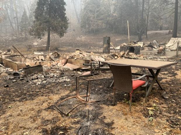
Fire destroyed the Douglas Fire Protection Agency Guard Station near Rock Creek. A lone chair survived. Credit: Kyle Reed, DFPA
Fire activity picked up Wednesday evening along the southeastern portion of the Archie Creek Fire in the Little River area. The activity was within the fire line near E-mile Creek where it reaches Little River Road. Firefighters worked there into the night and structure protection resources are on site. The Douglas County Sheriff reminded people of the current Level 3 “GO” evacuation level in the area and again urged residents there to leave.
Air resources were unable to fly yesterday due to the thick smoke. Four helicopters and two Single Engine Air Tankers are available for use when the smoke clears.On the far eastern portion of the fire, crews are working to hold the fire on Panther Creek Road. North of Highway 138E, in the Steamboat area, firefighters are working to keep the fire west of Canton Creek Road. Contract crews and National Guard crews continue mopping up hot spots near both containment lines and structures in these areas.
Highway 138E remains closed to all non-fire traffic from Milepost 21 through Milepost 83. Crews from the Oregon Department of Transportation, Douglas County Public Works Department, Pacific Power and their contractors continue to work along Highway 138E, Rock Creek Road and other county-maintained roads within the footprint of the fire.
The Archie Creek Fire has burned 128,020 acres and is 20% contained. There are currently 1,029 personnel assigned to this incident.
Archie Creek Fire Donations: At this time, the Archie Creek Fire management team does not need donations. To help firefighters and their families, contact the Wildland Firefighters Foundation at www.wwf.org or 208-336-2996.
To support the community, the following agencies and organizations are looking for donations and volunteers to help those who were affected by this fire.
Air quality: The Oregon Department of Environmental Quality at http://www.oregon.gov/deq
Closures:
September 16, 2020
Update for Sept. 16, 2020, 12:15 p.m.
Oregon Department of Forestry IMT 3 Link Smith, Incident Commander and Oregon State Fire Marshal’s Red Team Ian Yocum, Incident Commander
Holiday Farm Fire Information: 541-357-9729 (7am-10pm)
Lane County Non-Emergency Call Center: 541-682-3977 (7am-10pm)
Linn County Non-Emergency Call Center: 541-812-2260
Facebook: https://www.facebook.com/HolidayFarmFire/
Email: holidayfarmfireinfo@gmail.com
Springfield, Ore. –The overnight infrared flight mapped the Holiday Farm Fire’s footprint at over 170,000 acres. The fire’s perimeter measures more than 260 miles or roughly Portland to Medford.
The suppression strategy uses a combination of roads, ridges and hand line to control the fire’s spread. Across the lengthy perimeter of the fire crews are making steady progress. Equipment operators are widening existing roads, building dozer lines and removing trees to create solid control lines. Hand crews are following up, connecting control features and completing burnout operations to remove fuels between the main body of the fire and control lines.
Structural firefighters continue to aggressively extinguish hot spots in and around homes, clearing 100 feet around structures. The focus today remains on mopping up around homes from Vida to Rainbow. Protection efforts also remain in and around homes in the Deerhorn Road and Greenpasture Road areas.
The Urban Search and Rescue Team has completed 770 structural evaluations in the fire area. The team started at the eastern edge of the fire in the community of Rainbow and have been working west down the Highway 126 corridor. The team expects to assess structures in the community of Blue River today. The team has assessed about 75 percent of the 1018 structures in the fire area. Structures include commercial buildings, residences and outbuildings.
As of today, the USAR team has identified:
- 503 have been destroyed (complete destruction of structure)
- 9 failed (high risk, may be subject to sudden collapse)
- 28 damaged (medium risk, structure is moderately damaged)
- 230 no damage reported (low risk, low probability of future collapse)
The Incident Meteorologist forecasted that today’s weather may lighten the smoke inversion which could increase fire behavior.
The Leaburg Dam has been repowered and refilled. It is now available as a strategic dip site for heavy helicopters as soon as conditions allow aircraft to fly safely.
The Lane and Linn County Sheriff Offices continue to work with fire operations personnel to modify evacuation zones where appropriate. For the latest information on evacuation areas, please visit:
Lane County: www.lanecounty.org/mckenziefire
Linn County: www.linnsheriff.org/fire_live_updates_sept_2020/
Please continue to monitor cell phones, landlines, local media and official information sources for evacuation updates. Fire managers request that the public please avoid the area.
Roads are closed in the fire area and much of the Willamette National Forest (WNF) and Northwest Oregon District BLM. Road hazards include falling trees and rocks and debris. For more information on closures on the WNF visit: https://www.fs.usda.gov/alerts/willamette/alerts-notices/?aid=61574
For more information on closures on the Northwest Oregon BLM visit: https://www.blm.gov/press-release/extreme-fire-activity-prompts-closure-bureau-land-management-lands-northwestern-oregon
Fire personnel are warmed by the community’s support but are unable to accept donations or use volunteers. The fire must use individuals with the appropriate qualifications.
| Estimated Size: |
170,637 acres |
| Containment: |
8% |
| Start Date/Time: |
9/7/2020, 8:20 p.m. |
| Expected Containment Date: |
10/29/2020 |
| Location: |
Lane County |
| Cause: |
Unknown |
| Personnel: |
783 |
| Assigned Resources:
Hand Crews:
Engines:
Dozers:
Water Tenders:
Other Heavy Equipment: |
22
51
31
17
2 |
| Assigned Aircraft:
Structure Task Forces: |
7
6 |
| Injuries: |
0 |
| Structures Threatened: |
15,254 |
| Structures–
Destroyed:
Failed:
Damaged:
No Damage: |
503
9
28
230 |
|
|
|
Evacuations: |
Level 1 (READY), Level 2 (SET) and Level 3 (GO!) are in effect. |
|
September 16, 2020
Update for Sept. 16, 2020, morning
Incident Commander: Southern Area Incident Management Gold Team
Fire Information Line: 541-595-8227
Community Meetings: None planned
Acres: 8,645
Containment: 1%
Location: Diamond Lake Ranger District, Umpqua National Forest, about 5 miles north of Crater Lake National Park and within 1 mile of Diamond Lake Resort.
Cause: Unknown
Evacuations: Level 3 evacuations are in place for the Diamond Lake, Lemolo Lake, Toketee Ranger Station areas.
Fire summary:
Fire Activity and Operations: The spread potential for the fire is still high and firefighter safety remains a concern due to limited access, steep terrain and spread towards Cinnamon Butte. Today, crews will focus on direct attack, point protection for critical infrastructure and securing and holding the southern edge of fire near the northern edge of Diamond Lake. Smoke over the fire is inhibiting air operations although some missions were able to be completed yesterday. Execution of planned containment lines along the western edge will require hand crews where dozers cannot be used.
Closures and Flight Restrictions: Highway 138 E is closed. The Umpqua National Forest, including the Diamond Lake Ranger District, is closed until further notice due to unprecedented fire activity. The closure orders and associated maps are available on the Umpqua web page. Prohibitions include: being upon a closed road; going into or being upon a closed area; and being on a trail. A temporary flight restriction is currently in place to provide a safe environment for fire-fighting aviation operations.
Weather: Southwest winds, minimal cloud cover and temperatures in the low 70s will continue to support conditions for active fire behavior. Dry and breezy conditions are expected in the afternoon. Overnight recoveries should generally improve through the week. The trough responsible for the breezy winds will slowly move onshore over the next few days, with chances for light precipitation increasing from west to east, and a slight chance of thunderstorms tomorrow.
September 16, 2020
Update for Sept. 16, 2020, 9 a.m.
Incident Commander (northern zone): Northern Rockies Incident Management Team 2
Email: 2020.Slater@firenet.gov
Phone: 530-324-2528 Hours: 8am to 9pm
Facebook: https://www.facebook.com/SlaterAndDevilFireInformation/
InciWeb: https://inciweb.nwcg.gov/incident/7173/
Acres: 30,998 in Oregon
Containment: 10%
Location: SE of Cave Junction, Oregon (also in Northern California)
HAPPY CAMP, CALIFORNIA — Fire behavior on the Slater Fire is anticipated to remain calm today, due to continued high relative humidity. Humidity levels overnight stayed relatively high, even on ridgetops, and forecasts say moisture will increase throughout the day today with a chance of rain over the fire area tomorrow or Friday. Most of the recent fire growth has occurred on the Devil Fire, north into Butte Fork drainage. The Slater Fire also spread towards the Devil Fire yesterday, where conditions are still somewhat drier than down canyon. No structures were lost overnight on the Slater Fire.
Today, crews will continue to build direct fireline along the east side of the Pacific Crest Trail and prep along that trail to the south to protect the town of Seiad from the Devil Fire. Assigned resources there are planning to spike out for several days to complete this task. Meanwhile, indirect fireline construction immediately around Seiad continues to be improved.
Other priorities for firefighters in the south zone of the Slater Fire today include containing the fire on the north side of the road and protecting residences in Thompson Creek and Fort Goff areas. Today the aim is to complete indirect line to prevent the fire from spreading south of Highway 96 between Seiad and Happy Camp where it is burning along a bench above the road. Firefighters will also use strategic firing as needed on the east slope of the Thompson Creek drainage to protect private properties.
Near Gasquet, firelines are holding along Knopki Road, despite limited available resources there. Firefighters are working to scout control lines along Monkey Ridge and Oregon Mountain Road to prevent the fire’s spread into communities southwest of the fire.
In Oregon, Slater Fire growth was also minimal, with backing and flanking fire behavior. Fire resources on the ground there sought opportunities to directly contain the fire in its current footprint and establish contingency lines. Additional resources are arriving to the north zone of the Slater Fire today.
The Oregon State Fire Marshal’s Office has mobilized 10 task forces of structure fire engines, six from Oregon, three from Utah, and one from Washington State. Today crews will be holding the fire along the road system on the west side of the fire near the state line. In the Takilma area, dozers will continue to put in line and work direct on the north side of the fire.
Northern Rockies Incident Management Team 2 assumed command of the northern zone of the Slater Fire (including areas around Gasquet in California) at 6 a.m. today. The southern area of the Slater Fire and the Devil Fire will remain under command of California IIMT 10 for now. Information will still be disseminated via one Facebook page to avoid confusion.
A new fire start—the Fox Fire—discovered by aircraft on the Klamath National Forest two days ago is burning southwest of Callahan, and is now estimated at roughly 761 acres. EVACUATION ADVISORIES and ORDERS are in effect for Callahan area due to this fire – see the Siskiyou County Sheriffs Facebook page for updated details. The fire is active on its north edge, where reports from the field say groups of trees are torching. This fire has also moved westward past Blue Jay Ridge towards Joe Keen meadows. The south zone Slater Fire is supporting suppression efforts on the Fox Fire until additional resources arrive.
Due to extreme fire danger, all National Forests in California closed September 9, and remain closed. More details on these closure orders, along with fire restrictions orders, can be found on National Forest websites and on InciWeb.
As a result of extreme fire danger, the Bureau of Land Management Medford District has temporarily closed all Bureau of Land Management-administered public lands south of Grants Pass, Interstate 5, and U.S. Route 199 to the border of the Rogue River-Siskiyou National Forest. Maps of the closure areas are available on the Bureau of Land Management’s website: https://www.blm.gov/programs/public-safety-and-fire/fire-and-aviation/regional-info/oregon-washington/fire-restrictions.
Highway 199 remains closed from O’Brien south almost to Gasquet. Highway 96 is now open to one-way controlled traffic. Drivers traveling this section of highway should expect delays and use caution due to poor visibility. Other highways in Oregon are also being impacted by the smoke.
EVACUATION INFORMATION:
September 16, 2020
Update for Sept. 16, 2020, morning
Northwest Incident Management Team 9 (Incident Commander Brian Goff)
Email: 2020.archiecreek@firenet.gov
Phone: 971-334-7674 Hours: 7am-8pm
InciWeb: https://inciweb.nwcg.gov/incident/7176/
Facebook: https://www.facebook.com/Archie-Creek-Fire-Information-120244459815292/
Evacuations, shelter areas: The Douglas County Sheriff announced that Idleyld residents will be allowed to visit homes Thursday, Sept. 17 from noon until 7:00 pm. Fire managers and the Sheriff’s Office urge residents returning to their homes to drive cautiously and watch for falling hazards such as trees and debris.
An interactive evacuation map from the Douglas County Sheriff’s Office can be found online at www.dcso.com/evacuations.

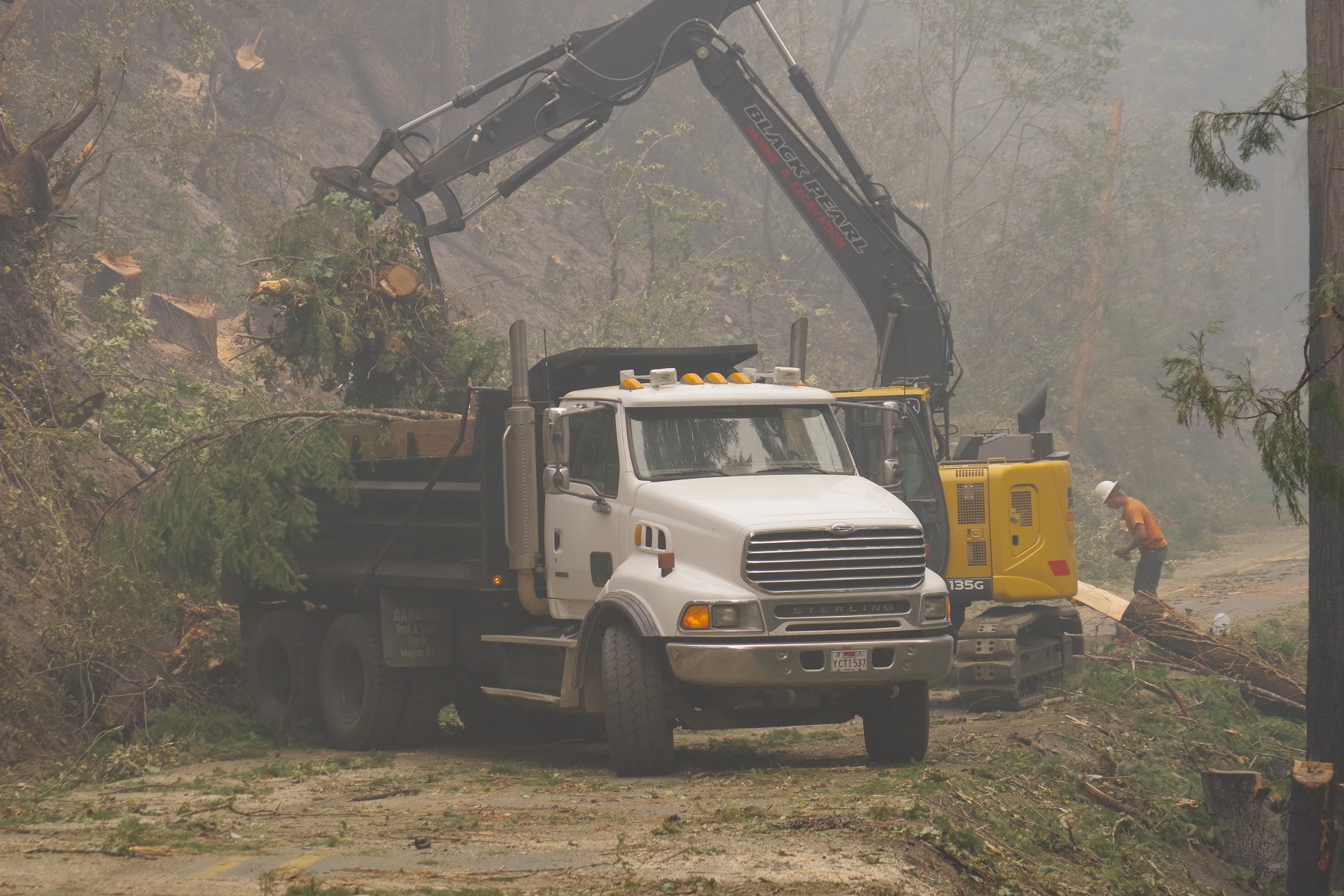
Equipment clearing roads on the Archie Creek Fire. Credit: DFPA
Fire summary:
Firefighters continue to work in the Little River area with heavy machinery, engines and crews, to construct and hold containment lines. Structure protection resources remain in place along Little River Road. On the far eastern portion of the fire, crews are allowing the fire to slowly back down the hillside to Panther Creek where crews have prepared roads to hold the fire. Heading north from Highway 138E, firefighters are scouting and constructing both primary and secondary containment lines from the Canton Creek area into the Upper Rock Creek area. Containment lines from South Calapooya Creek down to Glide continue to hold.
Suppression efforts on the Archie Creek Fire were boosted yesterday by an additional 125 personnel from the Oregon National Guard. These soldiers are working to hold containment lines around the perimeter of the fire and mop-up hot spots near structures. Total personnel assigned to the incident is now 773 people.
Air resources were grounded again yesterday due to safety concerns because of the thick smoke. Four helicopters and two Single Engine Air Tankers (SEATs) remain available in the area for use when the smoke clears.
Winds today are likely to push the smoke from west to east, providing some relief to residents and firefighters. When smoke lifts, temperatures will rise and humidity will decrease leading to increased fire activity.
Highway 138E remains closed to non-fire traffic from Milepost 21 through Milepost 83. Crews from the Oregon Department of Transportation, Douglas County Public Works Department, Pacific Power and their contractors continue to work along Highway 138E, Rock Creek Road and other county-maintained roads within the footprint of the Archie Creek Fire.
The Archie Creek Fire has burned 125,498 acres and is 20% contained. The breakdown of acres by ownership include:
- 62,623 acres of private lands
- 38,536 acres of Bureau of Land Management (BLM) lands
- 24,300 acres of US Forest Service (USFS) lands
- 39 acres of State of Oregon lands
Archie Creek Fire Donations: At this time, the Archie Creek Fire management team does not need donations. To help firefighters and their families, contact the Wildland Firefighters Foundation at www.wwf.org or 208-336-2996.
Glide Helping Hands: Distribution center for food and clothing. Call 541-733-6860 to leave a message and let them know how you would like to help.To support the community, the following agencies and organizations are looking for donations and volunteers to help those who were affected by this fire.
For further information:
Inciweb https://inciweb.nwcg.gov/incident/closures/7176/
Douglas County Sheriff website www.dcso.com/evacuations and Facebook page at https://www.facebook.com/DouglasCoSO
Air quality: The Oregon Department of Environmental Quality at http://www.oregon.gov/deq
Road closures: Monitor www.tripcheck.com for updates on the highway closures.
Bureau of Land Management (BLM): all lands east of Interstate 5, within the Swiftwater Resource Area are closed.
Umpqua National Forest: Maps and closure orders can be found on Inciweb at: https://inciweb.nwcg.gov/incident/closures/7176/. Additional information on the Forest Service closures are available at: https://www.fs.usda.gov/alerts/umpqua/alerts-notices managed lands east of Interstate 5, within the Swiftwater Resource Area are closed.
September 16, 2020
Update for Sept. 16, 2020, morning
COQUILLE, Ore. – The N Bank Rd MM8 fire is 100% contained. Mop up is in progress. The firefighters are locating and putting out hot spots as well as locating and removing hazards. The road has been opened from Hwy 42 to Beaver Hill. Again thank you to all of you for your continued patience.
September 15, 2020
Update for Sept. 15, 2020
COQUILLE, Ore. –
The North Bank Rd MM8 fire is still holding. The windy conditions yesterday afternoon has not caused any further issues. Firefighters are still working on containment lines and fire line hazards. The fire remains at 350 acres. The road remains closed, they will be looking into the road closure today as to whether they can open it or not. We will have a flight over the fire today to check the condition of the fire from above. Weather is shifting to warm, gusty, and breezy, however the firefighters are confident they will not have a problem with reaching containment of this fire. The containment is at 70% which is good news, we are more than half way to complete containment. Our hope is to bring more good news later. Thank you for all you are doing for our firefighters out there especially for your support.
September 15, 2020
Update for Sept. 15, 2020, 4:30 p.m.
Incident Commander: Southern Area Incident Management Gold Team
Fire Information Line: 541-595-8227
Community Meetings: None planned
Ranger District: Diamond Lake
Acres: 6,700
Containment: 1%
Location: 5 miles north of Crater Lake National Park and within 1 mile of Diamond Lake Resort
Date Discovered: Sept. 8, 2020 0830 PDT
Cause: Unknown
Evacuations: Level 3 evacuations are in place for the Diamond Lake, Lemolo Lake, Toketee Ranger Station areas.
Fire summary:
Idleyld Park, Ore. — The Southern Area Incident Management Gold Team today assumed command of the Thielsen Fire on the Diamond Lake Ranger District, Umpqua National Forest. The Team would like to thank the Southern Area Incident Management Gray Team for its service to the local community while working on the fire the last few days.
The Southern Area Incident Management Gold Team assumed command of the Thielsen Fire at 0700 today. The spread potential for the fire is still high and firefighter safety remains a concern due to access to fire and steep terrain, including spread towards Cinnamon Butte. Crews plan to use direct attack where possible, using heavy equipment and firing as needed.
Although smoke may limit daytime heating and wind strength, dry and breezy conditions are expected each afternoon over the next several days, with gusty south to southwest winds. Overnight recoveries should generally improve through the week. The trough responsible for the breezy winds will slowly move onshore over the next few days, with chances for light precipitation increasing from west to east late this week, and a slight chance of thunderstorms on Thursday.
Closures: Highway 138E & 230 is closed.
Prohibitions include:
1. Being upon a closed road.
2. Going into or being upon a closed area.
3. Being on a trail.
A temporary flight restriction is currently in place to provide a safe environment for firefighting aviation operations.
September 15, 2020
Update for Sept. 15, 2020, 1 p.m.
Oregon Department of Forestry IMT 3 Link Smith, Incident Commander and Oregon State Fire Marshal’s Red Team Ian Yocum, Incident Commander
Holiday Farm Fire Information: 541-357-9729 (7am-10pm)
Lane County Non-Emergency Call Center: 541-682-3977 (7am-10pm)
Linn County Non-Emergency Call Center: 541-812-2260
Facebook: https://www.facebook.com/HolidayFarmFire/
InciWeb: https://inciweb.nwcg.gov/incident/7170/
Email: holidayfarmfireinfo@gmail.com
Springfield, Ore. – The Urban Search and Rescue Team has completed 431 structural evaluations in the fire area. The team started at the eastern edge of the fire in the community of Rainbow and have been working west down the Highway 126 corridor. The team expects to assess structures in the community of Blue River today. The team has assessed approximately 30 percent of the 1018 structures in the fire area. Structures include commercial buildings, residences and outbuildings.
Of the 431 structures evaluated by the team:
- 315 have been destroyed or failed (308 destroyed, 7 failed)
- 102 no damage reported
- 14 damaged
To ensure accurate information, Lane County partners are finalizing a process on how to release the damage assessments and share more detailed information with property owners. The Lane County Office of Emergency Management Call Center is available to assist homeowners and residents with damage assessment information. The Lane County Call Center can be reached at: 541-682-3977.
Structure protection, infrastructure rebuilding and wildland fire suppression activities continue throughout the fire area.
Structure protection continues to remain a high priority. Firefighters will work throughout the day to extinguish hot spots in and around structures along Highway 126. They are also mopping up along Highway 126.
Night crews conducted a burnout operation on the southwestern area of the fire on industrial timberlands above Deerhorn Road. The embers from the burnout started small spot fires that required crews to build additional fire control lines.
The Incident Meteorologist forecasted that today’s weather may lighten the smoke inversion which could increase fire behavior.
On a fire of this scale, fire crews are conducting small burnout operations to connect fire control lines and limit fire spread. In addition, the fire crews are using bull dozers and other heavy equipment, largely provided by private industrial landowners, to construct containment lines along the fire edge or open up existing road systems in preparation for additional burnout opportunities.
The Leaburg Dam has been repowered and refilled. It is now available as a strategic dip site for heavy helicopters with quick access to the most populated areas near the fire perimeter.
The Lane and Linn County Sheriff Offices continue to work with fire operations personnel to modify evacuation zones where appropriate. For the latest information on evacuation areas, please visit:
Lane County: www.lanecounty.org/mckenziefire
Linn County: www.linnsheriff.org/fire_live_updates_sept_2020/
Please continue to monitor cell phones, landlines, local media and official information sources for evacuation updates. Fire managers request that the public please avoid the area.
Roads are closed in the fire area and much of the Willamette National Forest (WNF) and Salem/Eugene BLM. Road hazards include falling trees and rocks and debris. For more information on closures on the WNF visit: https://www.fs.usda.gov/alerts/willamette/alerts-notices/?aid=61574
For more information on closures on the BLM visit: https://www.blm.gov/press-release/extreme-fire-activity-prompts-closure-bureau-land-management-lands-northwestern-oregon
Fire personnel are warmed by the community’s support but are unable to accept donations or use volunteers. The fire must use individuals with the appropriate qualifications. Those looking to volunteer or donate can connect with local organizations at: https://www.lanecounty.org/cms/one.aspx?pageId=17035134
| Estimated Size: |
166,573 |
| Containment: |
6% |
| Start Date/Time: |
9/7/2020, 8:20 p.m. |
| Expected Containment Date: |
10/29/2020 |
| Location: |
Lane County |
| Cause: |
Unknown |
| Personnel: |
767 |
| Assigned Resources:
Hand Crews:
Engines:
Dozers:
Water Tenders:
Other Heavy Equipment: |
20
50
27
13
2 |
| Assigned Aircraft:
Structure Task Forces: |
7
5 |
| Injuries: |
0 |
| Structures Threatened: |
23,456 |
| Structures Damaged: |
14 |
| Structures Destroyed: |
315 (7 failed) |
| Evacuations: |
Level 1 (READY), Level 2 (SET) and Level 3 (GO!) are in effect. |
September 15, 2020
Update for Sept. 15, 2020, 10 a.m. – Final update
General Fire Information Line: 541-776-7338
Fire summary:
As of this morning, the Almeda Drive Fire is currently 100 percent contained.
At 0800, the Oregon State Fire Marshal Incident Management Team turned the incident over to local agencies. The contact information for the Almeda Drive Fire continues to be the following:
Almeda Drive Fire has transitioned to a stabilized phase of the incident. An Urban Search and Rescue Team, Utah Taskforce 1, with members from Utah and Nevada are conducting assessments, hazard mitigation as well as detailed searches.
Fire and utility crews continue to focus their efforts inside the fire line to mitigate current hazardous conditions which include fire debris, unstable structures, downed utility lines, as well as venting natural gas lines.
We continue to urge all citizens to stay away from evacuation zones as crews actively work to address hazardous conditions.
Temperatures are expected to reach the mid 70s today and remain for the next several days. It will be partly cloudy with overcast smoke and haze. Air quality conditions remain hazardous.
If you fly, we can’t fly. All citizens are asked to keep your drone on the ground. If drones are in the airspace, aviation resources will be grounded and won’t be able to fight fires that are threatening homes, lives, and communities.
Persons with respiratory illnesses should remain indoors to avoid inhaling smoke. If driving, slow down, use your headlights, and leave plenty of distance ahead of you. Info:
https://bit.ly/33CsXsS
Shelter for homeowners affected by the fire can contact the Jackson County Expo at 541-774-8270.