There is a community meeting planned for Sunday, July 19, 2026, at 2:00 p.m. to provide a brief operational update on the fire:
In Person: Shady Cove School Gym, 100 Cleveland St, Shady Cove, OR 97539
Stream online via: Facebook.com/ODFSouthwest
All lines holding on East Evans Creek Fire, resources prepare for critical fire weather to return
SAMS VALLEY, Ore. – Overnight, firefighters on the East Evans Creek Fire pushed forward on progress, holding and strengthening existing line around the fire and spot fires, and constructing new line where needed. This morning, the fire is 13,999 acres and containment has increased to 8%.
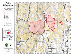
On the main fire, mop-up operations continued Friday night across the southern, western and northern flanks. All control lines are holding well and firefighters in these areas worked to bolster lines and add depth. To the southwest, wildland firefighters held and strengthened lines on the spot fire northwest of Hull Mountain, with no new overnight growth. Today, firefighters will focus on the northern flank, building and improving lines, and removing hazard trees to eliminate threats to resources working in the area.
Lines on the north, east and west sides of the Board Mountain spot fire are holding, and firefighters continued to connect hose to allow for more water flow across the fire. To date, 50 miles of hose lay has been installed across the incident. Additional work is needed in some areas on the southern tip where bulldozers have been unable to access. Today, hand crews will get into these areas with a goal of completing these portions of fireline.
On the Canyon Creek spot fire closest to Shady Cove, lines held well overnight and firefighters worked on mop-up operations and improving line where needed. To the east, resources are building alternate lines as a precaution between the fires and Shady Cove, Trail and surrounding communities.
Structural firefighters continued overnight mop-up operations around threatened structures, using thermal imaging cameras (TICs) to detect and extinguish hidden pockets of heat that could rekindle during the day. In areas where heat has been significantly reduced, structural crews are transitioning from active mop-up to patrol status while continuing to monitor conditions and respond quickly to any new fire activity.
The past 36 hours provided a break in high temperatures and lower relative humidity, and resources took advantage of those opportunities to the fullest; today, hotter, drier weather will return, and firefighters are prepared for the potential of increased fire activity once again. Temperatures will peak in the mid-90s, relative humidity will drop to near 20% and winds are expected to pick up in the afternoon, gusting up to 25 miles per hour.
With these conditions in the forecast, resources will be watching for spot fires and areas where the fire could threaten existing lines. Along with these conditions, the inversion is expected to lift and smoke will likely clear. Clear air will allow aircraft to safely fly and assist firefighters on the ground with intel and firefighting efforts.
Evacuations: There are evacuations in place in both Jackson and Douglas counties, issued by both counties’ Sheriff’s Offices and Emergency Management. Up-to-date evacuations are available here: https://readyjacksonco.com/Emergency/emergency-information-hub-east-evans-creek-road-fire
Find your evacuation zone here: https://tinyurl.com/EastEvansCreekFireEvacMap
Road/Land Closures: The Tiller-Trail Highway is closed at the county border in Jackson County to Highway 62. Traffic is closed to the public on East Evans Creek Road at Meadows Road. The BLM has issued a road closure for West Fork Evans Creek Road and Rock Creek Road. Please avoid the fire area to allow firefighters and heavy equipment to operate safely. Road closure information is available on https://tripcheck.com/
A closure order for BLM-administered lands near the East Evans Creek Fire is in place. Public entry, including hunting, hiking, and camping, is prohibited. More information about the closure, including a map, is available online at www.blm.gov/orwafire.
Smoke Impacts: Smoke from the East Evans Creek Fire may settle into valleys and other low-lying areas, reducing visibility and impacting air quality in nearby communities. Smoke conditions can change throughout the day as winds shift. Individuals sensitive to smoke should take appropriate precautions. For current air quality information and smoke forecasts, visit: https://fire.airnow.gov/.
Temporary Flight Restriction (TFR): A “TFR” is in place for the fire area daily (24 hours) until further notice. Complete information is available at https://tfr.faa.gov/tfr3/?page=detail_6_4915
Flying a drone near or around a wildfire is illegal and compromises the safety of both pilots and firefighters and interferes with firefighting efforts.
Cause: The fire started on Friday, July 10th at 2:41 p.m. after a car crashed into a power pole, sparking dry vegetation in the area. The Jackson County Sheriff’s Office is currently investigating the cause of the crash.