August 13, 2016
On August 12, 2016, a fire near Selma broke out burning approximately 50 acres.
The Oregon State Police Arson Unit along with the Oregon Department of Forestry began an investigation. During the investigation, a Selma area transient was arrested on an unrelated warrant and lodged at the Josephine County Jail.
This person, Marcus A YEOMAN, age 35, quickly became the person of interest in the fire. The Oregon Department of Forestry and the Oregon State Police Arson Unit’s investigation is finding that the fire was human-caused. On August 13, 2016 he was cited for Reckless Burning. This was after evidence revealed he had built a campfire which led to the wildland fire.
This is an ongoing investigation and no further information will be released at this time.
August 13, 2016
Oregon Department of Forestry firefighters from the Medford Unit are working this morning to extinguish the 5-acre Twentymile Springs Fire near Milepost 20 on Hwy 66, east of Ashland near Tubb Springs Wayside. The fire was reported at 6:50 a.m. by Soda Mtn. Lookout.
One large (Type 1) helicopter, four engine crews and a bulldozer have been assigned to the fire. Greensprings Fire-Rescue firefighters and equipment are also assisting.
The cause of the fire is under investigation.
August 13, 2016
Fire crews worked through the night cooling hot spots and monitoring fire lines on the Redwood Highway Fire in Selma. The cool and calm nighttime temperatures allowed for continued progress to be made on the line with 87 percent containment. The fire size remains at approximately 50 acres. The cause of the fire is under investigation.
Just before sunrise, firefighters discovered a 1/100th of an acre spot fire 1,000 feet outside of the current fire line. Within minutes, firefighters extinguished the flames and formed a wet line along the perimeter. Throughout the day, ground crews and air attack will continue to monitor the fire securing the perimeter and watching for snags, spotting, and flare ups. The goal is to ensure the fire perimeter is 100 percent lined by this evening.
Firefighters working on structural protection and prevention this morning uncovered three homes, and at least five outbuildings destroyed by the fire. It was originally thought by fire crews that only two homes were lost on Deer Creek Road; however, the daylight revealed that there were two homes on one property, a main house and guest house. All residents managed to safely evacuate. Firefighters will continue to search for additional structures damaged or threatened in the burned area.
Deer Creek Road remains under evacuation this morning. Residents on the 975 block and above on Deer Creek Rd. are at a “Be Set” Level 2 evacuation notice. Residents on the 974 block and below on Deer Creek Rd. remain at a “Go” Level 3 evacuation status. The road is closed to the public. After an additional assessment early this afternoon, Incident Command will revisit the option of reopening the road and changing evacuation levels. Residents seeking shelter assistance should visit the American Red Cross location in Cave Junction at 200 W. Watkins Street.
Redwood Highway is back open, but caution is advised. Firefighting operations are still occurring along the road and areas of smoke may be present.
The weather conditions today call for warm temperatures with variable wind gusts and low relative humidity. A fire weather watch will be in effect this afternoon beginning at 3 p.m. and ending at 8 p.m. We would like to thank all of the emergency agencies in Jackson and Josephine Counties that are assisting us and the public during this fire. We appreciate everyone’s quick response and collaboration.
The Oregon Department of Forestry Southwest Oregon District would like to remind the public that regulated use closures are in effect on ODF-protected lands in Jackson and Josephine Counties.
August 12, 2016
The first report of the Redwood Highway Fire in Selma came in at 3:34 p.m. Friday afternoon. At the time it was estimated at 1/10th of an acre in size with a consistent rate of growth burning in tall grass and dry brush on the west side of Redwood Highway. Within twenty minutes, the fire jumped the road and continued growing on the east side of Redwood Highway and up Deer Creek Road. The fire is now estimated to have grown to be between 50 to 75 acres with 85 percent dozer lined. We are working on an exact percentage of containment. The fire is under investigation.
Firefighters are currently working on holding the fire lines. Tree torching and spotting were initial issues firefighters on the ground were facing. Three Type 2 helicopters, a heavy helicopter, two air tankers, and one fixed-wing plane have been flying over the fire helping with cooling and suppression.
Residents on the 975 block and above on Deer Creek Road are at a Level 2 Evacuation. Homes on the 974 block and below on Deer Creek Road remain at a Level 3 Evacuation notice, along with all residents on Davis Creek Road. Four outbuildings and two homes were destroyed in the fire. The families of the two homes lost at 261 and 435 Deer Creek Road have been contacted. The American Red Cross is reaching out to help all families displaced by the Redwood Highway Fire at this time. All people originally evacuated to Boy Scout Camp near Lake Selmac are now being directed to the American Red Cross’ location at the United Methodist Church at 200 W. Watkins Street in Cave Junction. We are also setting up a community information center at the Red Cross shelter.
Deer Creek Road and Davis Road will remain closed at this time. Redwood Highway is back open.
Currently, crews from the Oregon Department of Forestry, Illinois Valley Fire District, Rural Metro Fire, Jackson County Fire District 5, Jackson County Fire District 3, Medford Fire-Rescue, Ashland Fire-Rescue, Applegate Valley Fire District, Oregon State Police, Josephine County Sheriff’s Office and Search & Rescue, Jackson County Emergency Management, Oregon Department of Transportation, Josephine County Public Works, American Medical Response, American Red Cross are all working together on different aspects of the fire response.
As always, we would like to remind the public that Fire Restrictions are in place on lands protected by the Oregon Department of Forestry in Jackson and Josephine Counties. For more on current fire regulations visit www.swofire.com.
Fire Information: (541)613-6313
August 9, 2016
Wildfires are often fast-spreading and unpredictable making it difficult for ground crews to navigate alone. This is why firefighting aircraft are an integral part of fire suppression.
However, aircraft cannot be used to fight fire if UAS (Unmanned Aircraft Systems), more commonly known as drones, are detected above or within a 5-mile radius of a wildfire. Both UAS and firefighting aircraft fly at low altitudes creating the potential for a mid-air collision which can injure or kill firefighters in the sky, crews on the ground, and the neighboring public.
This dangerous situation is why we ground all aircraft until UAS are removed from a wildfire. While aircraft is suspended, wildfires have the capacity to grow larger threatening more lives and property.
Please join ODF Southwest Oregon District in sharing our message: ‘If you fly, we can’t!’ Together, we can keep everyone in the air and on the ground safe allowing us to attack and suppress wildfires faster than if we worked alone.
Below is the link to our PSA and our Facebook page where the message is currently posted. Please share it on all platforms so that we may educate everyone on keeping drones away from wildfires.
ODF Southwest Oregon District YouTube:
https://www.youtube.com/watch?v=EeBkLTsBGts
ODF Southwest Oregon District Facebook:
https://www.facebook.com/ODFSouthwest/
August 5, 2016
Firefighters made great progress yesterday and were able to complete a strategic burnout on the northern flank of the Bybee Creek Fire, located in Crater Lake National Park. This firing operation will better secure the northern edge in case of high wind events and keep the fire south of Lightning Springs Trail.
Rim Village reported ash fallout yesterday afternoon. A predicted wind shift occurred, increasing fire activity on the northern flank. Fire activity did not increase closest to Rim Village.
An infrared flight occurred last night at 10 p.m. which showed the fire had grown to approximately 1,125 acres, and is 12 percent contained. This growth was primarily from firing operations that secured the already established control lines.
Increased fire activity with northwesterly winds is expected again today. Spotting and group torching will likely occur, followed by smoke and potential ash into Rim Village later in the afternoon.
Firefighters continue to monitor the small fire that is burning half way up the slope in the caldera. Less smoke was visible on the fire yesterday due to the lack of vegetation and pumice fields acting as natural barriers.
A structure protection group is in the area assessing threat to historical buildings which are in no immediate danger.
Nearly 380 personnel are assigned to the fire, along with 12 wildland fire engines, eight helicopters and two air tankers.
Fire danger continues to be high in the Crater Lake area with dry vegetation and changing weather. The public should be mindful of their surroundings and watch for updates.
Fire Restrictions: Crater Lake National Park implemented Stage Level 1 fire restrictions at midnight July 31, 2016. For more information visit: http://bit.ly/2b8gNfz
Level 1 Evacuation: Crater Lake National Park has issued a Level 1 Evacuation Notice for Rim Village and Park Headquarters until further notice. The Level 1 notice informs residents and visitors to “be ready” for a potential evacuation of Rim Village and Park Headquarters in the event that the Bybee Creek Fire approaches those areas. Mazama Village and other areas in the park are not affected by this Level 1 notice.
Closure: The Pacific Crest Trail is closed from Dutton Creek Camp north to the PCT parking lot on North Entrance Road. The Rim Trail is closed between Rim Village and North Junction. PCT hikers should use East Rim Drive as an alternate route. Lightning Springs Trail and backcountry camp are closed. The West Rim Drive from Rim Village to North Junction is temporarily closed.
August 3, 2016
The risk of wildfire is increasing across southwestern Oregon, and as a result, the Rogue River-Siskiyou National Forest is increasing the public use restrictions across much of the Forest.
“Southwest Oregon has experience several human-caused fires in the past few weeks. With the current fuels conditions, we feel it is important to implement public use restrictions to err on the side of caution,” says Eric Hensel, Fire Staff Officer for the Rogue River-Siskiyou National Forest. Effective 12:01 a.m. on August 5, 2016, the Rogue River-Siskiyou National Forest will impose public use restrictions that include limiting where open flames may occur, and areas where smoking or operating internal combustion engines is permissible.
Campfires must be built in Forest Service-constructed fire rings made of concrete or metal and located in designated recreation sites. With the exception of Sky Lakes Wilderness, wilderness areas within the Rogue River-Siskiyou National Forest are exempt from this restriction.
The use of propane or liquid fuel-powered commercial stoves is permitted. Smoking is allowed only while in vehicles, designated recreation sites, in areas clear of vegetation measuring at least 3 feet in diameter, or aboard watercraft on waterways. Welding or operating any other torch with an open flame is not allowed on Forest lands while these restrictions are in effect.
Operating an internal combustion engine is only permitted while in a vehicle on Forest Development Roads or within designated parking areas or while aboard a watercraft that is on water. Generators are allowed in designated recreation sites; please check with the Rogue River-Siskiyou National Forest before you camp to see if your destination is one of those designated sites. Additionally, internal combustion engine use is still permitted on the roads and trails at the Prospect OHV Trail System.
These public use restrictions will be effective until November 30, 2016, unless sooner rescinded.
The Industrial Fire Precaution Level will increase to IFPL 2 on the Wild Rivers, High Cascades, and Siskiyou Mountains Ranger Districts. Gold Beach and Powers Ranger Districts remain at IFPL 1.
Visitors to the Forest are encouraged to continue to be cautious with fire while in the woods. Forest officials remind recreationists to never abandon a campfire, and always ensuring that an extinguished campfire is cool to the touch.
For more information and to see the full text of the Forest Order, including a list of designated recreation sites where campfires are permitted, visit http://www.fs.usda.gov/alerts/rogue-siskiyou/alerts-notices.
August 3, 2016

The Bybee Creek Fire is 720 acres in size and is 12 percent contained. Nearly 300 personnel are assigned to the task of confining the fire, which is located in Crater Lake National Park. Firefighters are being supported by an air force of seven helicopters, four air tankers and eight wildland fire engines. The fire started July 28 and its cause is under investigation.
The Bybee Creek Fire slowed its spread Tuesday and firefighters were able to fight the fire directly from the Rim Road. The West Rim Road is still closed from the Rim Village to the North Junction until further notice, however, it is possible to travel through the park on the East Rim Road.
Firefighters are using several methods to suppress the fire’s growth, including direct and indirect methods. Today, a fuel break (handline) was completed around the fire to stop the fire from spreading.
Crews have prepared for fire operations along an old fire line and continue to utilize helicopters for water drops. Aerial water scoopers are also dropping water on the leading edge of the fire. If weather conditions are favorable, firefighters will put fire to the ground to consume the fuel between the fire and the handline.
Firefighters are working to achieve the goals of keeping the fire east of the Pacific Crest Trail, south of the Lightning Springs Trail and west of the Crater Lake Rim Drive.
Fire danger remains high, the public should be aware of their surroundings and prepared for changing conditions. A Level I Evacuation Notice has been issued for the Rim Village and Park Headquarters area. The Level I Notice informs residents and visitors to “be ready” for a potential evacuation if the fire approaches these areas. Mazama Village and other areas in the park are not affected by this notice.
Gusty winds are expected to continue for the next several days.
Crater Lake National Park implemented Stage 1 fire restrictions at midnight July 31, 2016.
The Park is open, the section of the West Rim road that is closed will not diminish your visit. It is still possible to drive the East Rim, enjoy the views from Rim Village and experience a boat ride around the Lake.
Closure Information: The Pacific Crest Trail is closed from Dutton Creek Camp north to the PCT parking lot on North Entrance Road. Lightning Springs Trail and backcountry camp are closed.
The West Rim Drive from Rim Village to North Junction is temporarily closed.
For more information:
July 29, 2016
Around 6 p.m. on July 28, ODF Southwest Oregon District and U.S. Forest Service firefighting crews responded to reports of smoke in the Applegate area.
Upon arrival, crews estimated the fire to be 10-11 acres in size with a moderate rate of growth. Command requested additional air craft and ground support in order to catch the fire before the 100-degree temperatures and mild winds helped it spread.

Two hours after the initial call, fire crews were able to knock down and contain the fire. A more accurate measurement was taken of the fire which showed the final size to be 8.4 acres.
The fire burned in the wild land 7.5 miles northeast of Applegate Lake, and 13.5 miles southwest of Medford.
Crews stayed late into the night mopping up and monitoring for any signs of fire activity.
The cause of the fire is under investigation by the U.S. Forest Service.
July 28, 2016
Increased fire danger on forestlands protected by the Oregon Department of Forestry’s Southwest Oregon District has made it necessary to increase the fire prevention measures on industrial operations, such as logging sites and other commercial operations. Industrial Fire Precaution Level II (two) takes effect at 12:01 a.m. on Friday, July 29, and includes the following restrictions:
- The use of fire in any form will be prohibited
- The use of power saws will be prohibited, except at loading sites, between 1:00 p.m. and 8:00 p.m.
- The use of cable yarders will be prohibited between 1:00 p.m. and 8:00 p.m.
- Blasting will be prohibited between 1:00 p.m. and 8:00 p.m.
- Welding or cutting of metal will be prohibited between 1:00 p.m. and 8:00 p.m.
Additionally, commercial operators on forestlands are required to have fire suppression equipment on site and provide watchman service.
These regulations affect all state, county, private and Bureau of Land Management lands in Jackson and Josephine counties. The regulated use zones affected by this proclamation include SW-1, SW-2, SW-3, SW-4, SK-3, RR-1, RR-2 and RR-3, and all forestland within one-eighth of a mile of these zones.
The public regulated use fire danger level remains at “high” (yellow).
For more information about the Oregon Department of Forestry’s fire season regulations, contact the unit office in your area:
- Medford Unit, 5286 Table Rock Rd., Central Point. Phone: (541) 664-3328
- Grants Pass Unit, 5375 Monument Drive, Grants Pass. Phone: (541) 474-3152
July 14, 2016
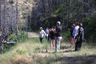
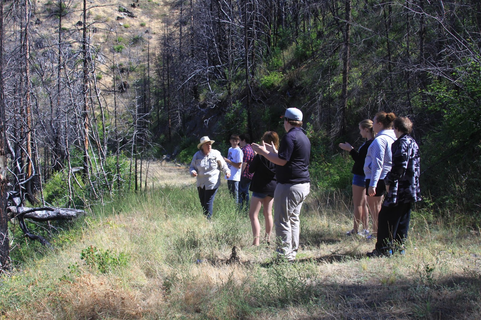
Students got the chance to visit the 155 acre 2014 Salt Creek Fire scar today near BLM’s Elderberry Flats Recreation Area. While at the site, they discussed the forest conditions at the time of the fire and how those condition
s influenced the fire’s behavior.
In addition, the students challenged themselves by talking about today’s forest health and how it will impact the future of wildfires in southern Oregon.
The Rogue River High School students will continue to get out in the field and learn about natural resources from a variety of forestry and firefighting professionals.
You and your family can also take part in wildfire education by getting involved with “Citizen Fire Academy.”
The Citizen Fire Academy (CFA) is a new program designed to educate the public on defensible space, wildfire safety, and Firewise communties.
July 12, 2016
The fire danger level on Oregon Department of Forestry-protected lands in Jackson and Josephine counties is increasing to “high” (yellow) today, Tuesday, July 12.
The Industrial Fire Precaution Level will remain at level 1 (one).
The fire prevention regulations put into effect on June 30 remain in force.
See the Fire Season Regulations page for details. Or, call or visit the Southwest Oregon District’s unit offices:
- Medford Unit, 5286 Table Rock Rd., Central Point, (541) 664-3328.
- Grants Pass Unit, 5375 Monument Dr., Merlin, (541) 474-3152.
July 8, 2016
Light rain overnight has prompted the Oregon Department of Forestry’s Southwest Oregon District to drop the fire danger level to “Moderate” (blue) today. The fire prevention regulations put into effect on June 30 remain in force. See the Fire Season Regulations page for details. Or, call or visit the Southwest Oregon District’s unit offices:
- Medford Unit, 5286 Table Rock Rd., Central Point, (541) 664-3328.
- Grants Pass Unit, 5375 Monument Dr., Merlin, (541) 474-3152.
July 4, 2016

Oregon Department of Forestry firefighters took action yesterday on two fireworks-caused fires, one east of Cave Junction in Josephine County and one just north of Central Point in Jackson County. Neither fire caused any injuries or damage to any structure.
Fireworks are part of many families’ Independence Day celebration, but care must be taken when using fireworks to ensure they don’t kindle a wildfire. Each spark from a firework is extremely hot — 1500 degrees — and will cause dry grass to immediately ignite. These hot sparks will also burn skin, hair and clothing.
When using fireworks, do so on a large, unburnable surface such as a concrete driveway. Have water or a fire extinguisher close at hand. Soak spent fireworks in a bucket of water before disposing of fireworks debris. Supervise children so they may enjoy fireworks without suffering injury to their fingers or eyes.
If a fire is caused or someone is injured, call 9-1-1 immediately.
Have a safe and fire-free Fourth of July.
June 28, 2016
Continued hot and dry weather has made it necessary for the Oregon Department of Forestry to raise the fire danger level to “high” (yellow) on Thursday, June 30. The Industrial Fire Precaution Level will remain at level 1 (one).
These regulations listed below affect 1.8 million acres of state, private, county, city and Bureau of Land Management lands in Jackson and Josephine counties that are protected by ODF’s Southwest Oregon District.
Fire prevention regulations currently in effect, and which will remain in effect, include:
- No debris burning, including piles and debris burned in burn barrels;
- No fireworks use on forestlands;
- Exploding targets and tracer ammunition, or any bullet with a pyrotechnic charge in its base, are prohibited;
- No sky lanterns may be used in wildland and forestland areas.
Starting Thursday at 12:01 a.m., the following regulations will go into effect:
- Campfires will be allowed only in designated campgrounds. Portable stoves using liquefied or bottled fuels may be used in other locations;
- Motorized vehicles will be allowed only on improved roads;
- Smoking while traveling will be allowed only in enclosed vehicles on improved roads;
- Possession of the following firefighting equipment is required while traveling, except on state highways, county roads and driveways: one shovel and one gallon of water or one 2½ pound or larger fire extinguisher. All-terrain vehicles and motorcycles must be equipped with one 2½ pound or larger fire extinguisher;
- Chain saws may not be used between 10:00 a.m. and 8:00 p.m. During other hours, chain saw users must have an ax, a shovel and an 8-oz or larger fire extinguisher at the job site, and a one-hour fire watch is required after the saw is shut down;
- Mowing of dead or dry grass with power-driven equipment will not be allowed between 10:00 a.m. and 8:00 p.m. This restriction does not include mowing of green lawns, or equipment used for the commercial culture and harvest of agricultural crops;
- The cutting, grinding or welding of metal will not be allowed between 10:00 a.m. and 8:00 p.m. These activities will be allowed during other hours provided the work site is cleared of potentially flammable vegetation and other materials, and a water supply is at the job site;
- Electric fence controllers must be approved by a nationally recognized testing laboratory, such as Underwriters Laboratories Inc., or be certified by the Department of Consumer and Business Services, and be installed and used in compliance with the fence controller’s instructions for fire safe operation.
For more information about the Oregon Department of Forestry’s public regulated use regulations, please call or visit the Southwest Oregon District unit office nearest to you:
- Medford Unit, 5286 Table Rock Rd., Central Point. (541) 664-3328
- Grants Pass Unit, 5375 Monument Dr., Grants Pass. (541) 474-3152
June 28, 2016
The fire danger level will be “high” (yellow) in the Wild and Scenic section of the Rogue River between Grave Creek and Marial starting 12:01 a.m. Thursday, June 30. The Wild and Scenic section of the river between Grave Creek and Marial is managed by the Bureau of Land Management and protected from fire by the Oregon Department of Forestry’s Southwest Oregon District.
The following fire prevention restrictions take effect Thursday:
- Smoking will be prohibited while traveling, except in boats on the water, and on sand or gravel bars that lie between water and high water marks that are free of vegetation.
- All travelers will be required to carry one shovel and a one-gallon or larger bucket.
- The use of fireworks will be prohibited.
- Campfires, including cooking fires and warming fires,will be prohibited. However, charcoal fires for cooking and built in raised fire pans will be allowed on sand or gravel bars that lie between water and high water marks that are free of vegetation. Ashes must be hauled out. Portable cooking stoves using liquefied or bottled fuels may also be used.
For further information about fire restrictions in the Wild and Scenic Section of the Rogue River between Grave Creek and Marial, contact:
- The Oregon Department of Forestry, Grants Pass Unit, (541) 474-3152;
- The Smullin Visitor Center located at the Rand National Historic Site at (541) 479-3735.
June 23, 2016
Fire crews from the Oregon Department of Forestry and Jackson County Fire District 3 participated in live fire training today. The training was at the intersection of Truax and Newland roads in Central Point.
This type of training allows firefighting crews to closely mimic a brush fire in a controlled environment that the fire training staff monitors. Firefighters worked on mobile attack, pump-and-roll tactics, burnout operations, and fire ground communications to refresh skills needed for the upcoming fire season.
Although the day started out slow due to the early morning humidity, it quickly turned into great conditions for the training. This video is a look at some of the collaborative work fire crews did today.
June 6, 2016
ODF Medford Unit engine crews found two lightning-caused fires this evening in northeast Jackson County. One fire is near Vine Maple Creek, 6 miles south of Prospect. The other fire is in the Sugar Pine Flat area, 4 miles northwest of Butte Falls. Both fires have firefighters on scene.
The Sugar Pine Flat Fire is estimated at 0.25 acre. The one near Vine Maple Creek is confined to a tree.
Other engine crews are looking through the Cobleigh Rd. and the Elk Creek Rd. areas where people have reported seeing small columns of smoke, however no other fires have been found.
Earlier today, ODF Grants Pass Unit engine crews assisted with extinguishing a 0.50-acre fire near the community of Provolt. The cause of that fire under investigation.
June 1, 2016
Fire season begins Friday, June 3, at 12:01 a.m. on lands protected by the Oregon Department of Forestry’s Southwest Oregon District. Lands affected by this declaration include state, private, county, city, and Bureau of Land Management forestlands in Jackson and Josephine counties.
The public regulated use fire danger level will be “moderate” (blue) and the Industrial Fire Precaution Level will be 1 (one).
Last year, fire season started on June 5 and ended October 28. A total of 255 fires burned on lands protected by the Southwest Oregon District, and blackened 347 acres. More than 200 of those fires were started by people and 53 fires by lightning. According to the 10-year average of fires on the district, 230 fires may burn more than 5,600 acres during fire season.
The 2016 fire season may be another very active one. A good snowpack in the Cascade Range and the Siskiyou Mountains recharged most of the southwest Oregon region’s reservoirs, but may have little positive effect on wildfire activity in the district, most of which covers low-elevation grass and brush lands and mid-elevation forests. Residual snowpack is at higher elevations on national forest and national park lands.
While spring was reasonably wet, it was also 6-8 degrees warmer than normal. Abundant grass and weed growth across the district will provide plenty of fuel for wildfires, once the vegetation fully cures. In addition, tree mortality from the drought has left numerous dead and dying trees scattered across the landscape. These may moderately increase the severity of forest fires in some parts of the district.
Beginning Friday, the burning of debris piles and the use of burn barrels for burning debris will no longer be allowed. Other public regulated use restrictions on ODF-protected forestlands include:
- No fireworks;
- No tracer ammunition or exploding targets;
- No sky lanterns.
Under Industrial Fire Precaution Level 1 on ODF-protected lands, commercial operations, such as timber harvesting conducted on forestlands, will be required to have fire suppression equipment on the job site at all times. A watchman must also be provided.
For more information about the Oregon Department of Forestry’s fire season regulations, please call or visit the Southwest Oregon District unit office nearest to you:
- Medford Unit, 5286 Table Rock Rd., Central Point. (541) 664-3328
- Grants Pass Unit, 5375 Monument Dr., Grants Pass. (541) 474-3152
May 31, 2016
Many Oregonians have good intentions when they set out to eliminate the fire hazards around the home. But the way they go about it may actually start a wildfire. Using the right tool in the right place at the right time is crucial during clean-up. Get any of these wrong, and the outcome could be disastrous.
In late July 2015, the Stouts Creek Fire in SW Oregon ignited, eventually growing to more than 26,000 acres and costing millions of dollars to put out. The blaze was caused by a resident mowing dry grass.
Spring is the time to clean up excess vegetation, not during the summer when fuels are dry and susceptible to a spark from a steel blade striking a rock or emitted by a hot exhaust system. Improper equipment use ranks as the No. 2 cause of wildfires on state-protected lands in Oregon.
FOLLOW CURRENT FIRE RESTRICTIONS – Check with the local Oregon Department of Forestry district or forest protective association to learn if there are any current restrictions or regulations on the use of internal combustion engines (lawn mowers, chainsaws, weed trimmers). Some areas may restrict their use depending on weather and vegetation conditions.
MOW BEFORE 10 A.M. – The best time of day to use gas-powered equipment is early morning, when the humidity is higher and temperatures are lower. Never mow when it’s windy or excessively dry.
USE THE RIGHT TOOL FOR THE JOB – Lawn mowers are designed to mow lawns, not weeds or tall, dry grass. Use a weed trimmer with plastic line, vs. metal blades that can strike rocks, create sparks and start a wildfire. Remove rocks in the area before you begin operating any power equipment to avoid sparks.
ALL PORTABLE GAS-POWERED EQUIPMENT MUST HAVE AN APPROVED SPARK ARRESTER – In wildland areas, an escaped carbon particle from a muffler may be all it takes to start a fire. This includes cars, tractors, harvesters, chainsaws, weed trimmers and mowers. Keep the exhaust system in proper working order, spark arresters clear of carbon build-up, and the engine free of oil and dust. Allow equipment to cool before refilling with gasoline. Use the recommended grade of fuel and don’t top it off.
Wildfire awareness, preparedness and prevention are crucial this year. Learn more at: www.keeporegongreen.org, and be a part of the solution.