September 14, 2017
A combination of higher relative humidities and cooler temperatures across southwest Oregon have made it possible to ease-off on some fire prevention regulations. The fire danger level on Oregon Department of Forestry-protected lands in Jackson and Josephine counties will be lowered to “high” (yellow) tomorrow, September 15, 2017 at 12:01 a.m. The Industrial Fire Precaution Level will remain at a level 3 (three).
Restrictions on the public use of chain saws, brush cutters and other power-driven or spark-emitting machinery are being slightly relaxed, allowing the use of equipment until 10:00 a.m. and after 8 p.m. Today will be the last day power-driven and/or spark-emitting machinery is completely prohibited.
Other fire prevention regulations which will remain in effect, include:
· No debris burning, including piles and debris burned in burn barrels.
· No fireworks on forestlands.
· Exploding targets and tracer ammunition, or any bullet with a pyrotechnic charge in its base, are prohibited.
· Campfires are allowed only in designated campgrounds. Portable stoves using liquefied or bottled fuels may be used in other locations.
· Motorized vehicles are allowed only on improved roads; one shovel and one gallon of water, or one 2.5 pound or larger fire extinguisher, is required while traveling.
· Smoking while traveling will only be allowed in enclosed vehicles on improved roads, in boats on the water and other specifically designated locations.
· Chain saws may not be used between 10:00 a.m. and 8:00 p.m. during high fire danger. During hours outside of this time frame, chain saws may be used but require that the operator have one shovel and one 8-oz or larger fire extinguisher at the work site. A fire watch is also required for one hour after each chainsaw use.
· Cutting, grinding, and welding of metal is not allowed between 10:00 a.m. and 8:00 p.m. during high fire danger. These activities will be allowed during hours outside of this time frame only if the work site is cleared of potentially flammable vegetation and other mat
erials, and a water supply is at the job site.
· The mowing of dead or dried grass with power-driven equipment is not allowed between 10:00 a.m. and 8:00 p.m. during high fire danger. This restriction does not include mowing of green lawns, or equipment used for the commercial culture and harvest of agricultural crops.
· Any other spark-emitting internal combustion engine-use not specifically mentioned is not allowed between 10:00 a.m. and 8:00 p.m. during high fire danger. Use of any spark-emitting internal combustion engine is allowed outside of this time frame only if the work site is cleared of potentially flammable vegetation and other materials, and a water supply is at the job site.
· Any electric fence controllers must be approved by a nationally recognized testing laboratory, such as Underwriters Laboratories Inc., or be certified by the Department of Consumer and Business Services, and be installed and used in compliance with the fence controller’s instructions for fire safe operation.
For more information about the Oregon Department of Forestry’s fire season public restrictions, please call or visit the Southwest Oregon District unit office nearest to you:
· Medford Unit, 5286 Table Rock Rd., Central Point. (541) 664-3328
· Grants Pass Unit, 5375 Monument Dr., Grants Pass. (541) 474-3152
Fire season information is also available online at our Facebook page: @ODFSouthwest and our website: www.swofire.com.
###
September 7, 2017
 Firefighters from the Oregon Department of Forestry’s Southwest Oregon District have already tackled six wildfires overnight; however, additional new fire starts are expected to pop-up as the temperatures begin to rise throughout the day. ODF’s Southwest Oregon District, which encompasses 1.8 million acres of land in Jackson and Josephine Counties, was pummeled with nearly 200 lightning strikes in a few short hours yesterday evening. Only a quarter of those hits were positive strikes, meaning the strikes are more powerfully charged compared to a negative strike; therefore, more likely to spark a wildfire. Firefighters will be gridding the landscape surrounding those confirmed positive strikes in order to try to catch any new starts while they are small.
Of the six wildfires located in the past 12 hours, five of them are 100 percent lined and 100 percent mopped up; all five were stopped at less than one acre in size. The sixth fire, being called the East Antelope Fire, was recently mapped at 3 acres. The fire burning six miles east of Roxy Ann Peak on Bureau of Land Management (BLM) forestland is close to being fully lined. Firefighters will continue making progress on this fire until we reach 100 percent containment.
In addition to firefighters patrolling on the ground, a FLIR-equipped aircraft is lending a helping hand to the District today. This aerial resource will utilize thermal imaging technology to help detect new starts throughout southern Oregon from high above all of the existing smoke. Additionally, ODF Southwest has its air attack platform and helicopters available for initial attack, as visibility allows.
With forecasted thunderstorms anticipated to roll into our region today, ODF firefighters will remain vigilant – knocking down new fires as quickly as possible. However, we need your help in preventing any and all human-caused starts. We would like to remind everyone that the fire danger level on Oregon Department of Forestry protected lands in Jackson and Josephine counties remains at “extreme” (red) today. For a full list of the public restrictions currently in place, visit our Facebook page: @ODFSouthwest or our website: www.swofire.com.
###
September 7, 2017
High relative humidity and slightly improved air quality has prompted the Oregon Department of Forestry’s Southwest Oregon District to drop the Industrial Fire Precaution Level (IFPL) to III (three) today, effective immediately.
Please note, this is separate from the general public fire restrictions currently in effect. ODF Southwest’s public restrictions remain in place and unchanged with a fire danger level of “extreme” (red).
The following are prohibited between 1:00 p.m. – 8:00 p.m.:
- Power saws at loading sites;
- Loading or hauling of any product or material;
- Blasting;
- Welding, cutting, or grinding of metal;
- Any other spark emitting operation not specifically mentioned.
In addition, the following are permitted to operate overnight to the morning, between the hours of 8:00 p.m. and 1:00 p.m., where mechanized equipment capable of constructing fire line is immediately available to quickly reach and effectively attack a fire start:
- Ground-based operations (tractor/skidder, feller-buncher, forwarder, or shovel logging operations);
- Power saws on ground-based operations;
- Rotary head saw feller-bunchers with a continuous Firewatch;
- Non-rotary head saw feller-bunchers;
- Tethered logging – winch-assisted, cable-assisted, traction-assisted, etc. systems, which enable ground-based timber harvesting machines to operate on steep slopes.
This is considered a restricted shutdown and the following activities are not permitted at any time, except as noted:
- Cable yarding systems, except that gravity operated logging systems using non-motorized carriages or approved motorized carriages may operate between 8:00 p.m. and 1:00 p.m., when all blocks and moving lines are suspended at least 10 feet above the ground (except the line between the carriage and the chokers).
###
September 1, 2017
Increased fire danger on forestlands protected by the Oregon Department of Forestry’s Southwest Oregon District has made it necessary to increase the fire prevention measures on logging and non-logging industrial operations, as well as all other commercial operations. Industrial Fire Precaution Level (IFPL) IV (Four) takes effect at 12:01 a.m. tomorrow, Friday, September 1, 2017.
Please note, this is separate from the general public fire restrictions currently in effect. ODF Southwest’s fire restrictions remain in place and unchanged with a fire danger level of “extreme” (red).
Under IFPL IV, all industrial actions are prohibited. Industrial actions include cable yarding, use of power saws, logging operations using tractors, skidders, feller-bunchers, mechanized loading or hauling, blasting, welding or cutting of metal, or any other spark-emitting operation not yet mentioned.
No waivers will be issued for harvest or road construction activities. Waivers may be considered on a case-by-case basis for extremely low risk operations.
ODF Southwest fully understands the burden that this places on our industrial cooperators and the local economy. This decision is never made lightly; in fact, it has been more than 20 years since ODF Southwest has issued a Level IV closure.
In regards to the duration of this closure, ODF Southwest personnel will be constantly monitoring several factors; including weather conditions and smoke forecasts – just to name a few, in order to lower the IFPL Level, as soon as safely possible.
August 13, 2017
After sixty straight hours of firefighting, the Nugget Fire is 100 percent lined as of today. Initially, the terrain posed too many challenges to crews to build a direct fire line, such as steep slopes, an abundance of hazard trees and poor access leaving limited to no escape routes. However, over the past 24 hours significant progress has been made in improving access and creating safety zones. Local contractors from Butte Falls to Roseburg were brought in to assist with the removal of numerous hazard trees all within the fire’s estimated 5 to 10 acre perimeter. This allowed firefighters overnight to switch tactics from building indirect line away from the fire’s edge, to constructing a control line up against the perimeter of the burning landscape. Firefighters are now set up for a more successful and safe firefight.
 Air operations continues to play a vital role in the Nugget Fire. The continuous bucket drops being made have helped cool hot spots while ground crews chipped away at their respective goals. While members of the community will still see helicopters dipping out of the Rogue River in Gold Hill, this is to continue to suppress the interior heat while firefighters on the ground begin mopping up from the perimeter moving inward.
 The Nugget Fire was first reported late Thursday night burning on Nugget Butte in Gold Hill. The cause of the fire is under investigation. We would like to thank our partners and members of the community for the continued support.
The series of fires near Grizzly Peak are now 100 percent lined and 90 percent mopped up. Firefighters will be combing the area this week in order to ensure that no additional hot spots are present. The trail system will remain closed until firefighters wrap up their work and feel that there is no longer a threat to public health and safety. Thank you all in advance for your patience.
Please keep in mind that we are still in “Extreme” Fire Danger in Jackson and Josephine Counties. Make sure you and your family are aware of the current fire restrictions in place. For additional information about the Oregon Department of Forestry’s current fire restrictions, please visit: ODF Southwest on Facebook, or www.swofire.com.
August 11, 2017
Today, ODF Southwest firefighters and our cooperators tackled numerous fires on ODF-protected land across Jackson and Josephine Counties. While this storm has pushed our team to its limits, we are holding true to keeping fires as small as possible, and keeping the community safe. Nearly every fire we have shared information on this week is close to being fully lined and in mop up, except for the following:
The Nugget Fire is still challenging firefighters as the steep terrain covered in snags poses a hazard to all personnel on the ground. Crews are continuing to work on fire line around the perimeter, but access is also playing a role in the demanding firefight. The fire is still estimated to be 5 to 10 acres by ODF’s air attack, but we have not yet mapped the fire due to the same challenges previously mentioned. Overnight, firefighters will be focusing on building and strengthening control line. While the fire will be letting off smoke, the fire activity remains moderate primarily in the interior of the burn. No homes are threatened by this fire.
Also, the series of Grizzly Peak Fires are being wrapped up, but additional mop up will be taking place tomorrow before we call all five of these fires 100% contained. Since air operations will continue cooling hot spots tomorrow, and firefighters will be working throughout the Grizzly Peak area, a temporary closure of the Grizzly Peak Trail system is in effect in order to protect public health and safety. For the full information on that closure, visit www.swofire.com.
We would like to thank the community for the tremendous amount of support we have all felt while working on countless number of fires since this storm took off Monday. We are also incredibly grateful for the partnerships in place with U.S. Forest Service Rogue River Siskiyou National Forest, Bureau of Land Management Medford District, all local city and county agencies, ODF Klamath-Lake District, Cal Fire and finally, Oregon Department of Forestry IMT I. The amount of fires we have been able to keep small is a testament to our superb partnerships throughout our area.
August 11, 2017
With increased fire activity on Grizzly Peak near Ashland, the Bureau of Land Management (BLM) Medford District jointly with the Oregon Department of Forestry Southwest Oregon District have decided that a temporary closure of the Grizzly Peak Trail system is necessary in order to protect public health and safety. The closure is effective immediately and will be in place until the area is deemed safe for public access.
Currently, firefighters are still engaged on Grizzly Peak; however, only three of the five fires initially reported are still actively burning. The first two fires were knocked down and 100% contained by early afternoon. Both are less than an acre in size. Firefighters are engaged on the final three fires tonight. The fires range from ¼ acre to 2 acres, and are each at least 30% mopped up and 100% lined. We will continue to work on these fires swiftly and efficiently in order to eliminate any further risk to public and firefighter safety.
Closure signs will be placed at main entry points to the area; however, maps of the closure area can be obtained through the BLM Medford District Office. The Grizzly Peak Trail is on federal land administered by the Bureau of Land Management out of its Medford District office. It is a popular hiking area that attracts several visitors during the summer months. Therefore, we hope this precaution keeps both visitors and firefighters safe as they continue to make progress on the series of fires on Grizzly Peak.
The full Emergency Closure Notification is below. For additional information, please reach out to the BLM Medford District office at (541) 618-2200, or the Oregon Department Southwest Oregon District Medford Unit at (541 664-3328.
###
U.S. DEPARTMENT OF THE INTERIOR
BUREAU OF LAND MANAGEMENT
MEDFORD DISTRICT
3040 Biddle Rd.
Medford OR 97504
EMERGENCY CLOSURE OF PUBLIC LANDS: Jackson County, Oregon
AGENCY: Bureau of Land Management, Medford District Office, Oregon
ACTION: Temporary closure of public land in Jackson County, Oregon.
SUMMARY: The Medford District, Bureau of Land Management (BLM) is giving notice that we are temporarily closing the Grizzly Peak Trails beginning on August 11, 2017. These restrictions are to protect public health and safety (43 CFR 9268.3(d)(1).
THE CLOSED/RESTRICTED AREA ARE:
The Grizzly Peak Trail system – Township 38S, Range 2E, Section 8, 17, 18, and Road 38S-02W-9.2.
BLM will post closure signs at main entry points to this area. You may obtain maps of the closure area and information from the Medford District Office.
DATES: This closure will be in effect from the date of signature until the area is deemed as safe for public access.
FOR FURTHER INFORMA TION CONTACT: Kristi Mastrofini, Ashland Resource Area Field Manager, 3040 Biddle Road, Medford, OR 97504, telephone (541) 618-2438.
DISCUSSION OF THE RULES: Under the authority of 43 CFR 9268.3(d)(1)(i), BLM will enforce the following rule on public lands within the closed area:
You may not travel on the Grizzly Peak trail in Township 38S, Range 2E, Section 8, 17, 18 or the road leading to the trail, Road 38S-02E-9.2 beyond Shale City Road.
EXEMPTIONS: Persons who are exempt from these rules include:
· Any Federal, State, or local officeror employee in the scope of their duties;
· Members of any organized rescue or fire-fighting force i n performance ofan official duty;
· Any personauthorizedin writing by the Bureauof Land Management.
PENALTIES: Authorities for this closure are section 303(a) of the Federal Land Policy and Management Act of 1976 (43 U.S.C. I733(a)) and 43 CFR 8360.0-7. Any person who knowingly and willfully violates any closure order issued under § 9268.3(c)(2) of this title shall be fined not more than $1,000 or imprisoned for not more than 12 months, or both. Such violations may also be subject to the enhanced penalties as provided for by 18 U.S.C. 3571.
August 10, 2017
ODF IMT 1
BILL HUNT, INCIDENT COMMANDER
Shady Cove, Oregon – Wednesday evening’s thunderstorm activity brought much needed precipitation to the Flounce Fire with as much as a quarter inch of rain in some areas. The fire stands at an estimated 690 acres and 10 percent contained.
While the rain served as a welcome relief to cool portions of the fire down, it also creates a slew of safety concerns. The added moisture on the ground, combined with burning root systems, weakens trees that could potentially fall at a moment’s notice, compromising firefighter safety and carrying burning material downhill across fire lines. Also of concern is the potential for rock slides in the steep, rugged terrain. The area of greatest concern is the southeast corner of the fire where the rocky cliffs make it difficult to establish solid containment lines. Helicopters will focus bucket drops in that area to support ground forces.
The west flank of the fire is in excellent condition. Crews will continue extensive mop up along the western line while also being available to support Oregon Department of Forestry’s Southwest Oregon District and its cooperators by responding to new fires in Jackson and Josephine Counties.
A Level One (Be Ready) evacuation notice remains in effect for residents on Evergreen Drive and Lewis Road near Prospect. Jackson County Emergency Management and local fire agencies will continue to coordinate with fire team personnel in evaluating the situation. Level One of the three-level ‘Be Ready, Get Set, Go!’ evacuation system is something everyone should incorporate into their daily lives. It’s all about having a plan, including assembled emergency kits, being aware of escape plans and evacuation routes and sites, and being ready to go at a moment’s notice, regardless of the emergency. Learn more at our local emergency managemt page
www.rvem.org, or
wildlandfirersg.org.Roughly 650 personnel are currently assigned to the Flounce Fire. Fire crews are also being supported with 9 helicopters, 19 engines, and 17 water tenders.
August 9, 2017
Today, ODF Southwest firefighters worked diligently chasing smokes and knocking down multiple fires throughout Jackson and Josephine Counties. While several of our starts are dead out, there are a handful of fires that crews are continuing to work on overnight.
The Stratton Creek Fire, burning seven miles northwest of Merlin, is estimated to be 30 acres as of nightfall. The fire originated as three separate fires burning in mixed terrain consisting of tall brush and timber on the north side of the Rogue River near Hellgate Canyon Bridge. Two of the three fires burned together late this evening which will pose a challenge to firefighters as they work to line the fire in a steep, rugged landscape. The third fire has already been completely knocked down by air and ground resources. Firefighters will continue to work on containment tonight. Air operations will resume in the morning.
The Reuben Fire, which we mentioned earlier today, was burning roughly five air miles north of Grave Creek Bridge and the Rogue River Trail. The initial estimate put the fire at five acres, but as of this evening the fire was knocked down and 100% lined at 10.75 acres. Crews will continue to mop up the interior of the fire tonight.
The Doe Spring Fire is burning right off the Josephine – Douglas County border just north of Mount Reuben. Thanks to the collaborative efforts between ODF Southwest and the Douglas Forest Protective Association, firefighters are inching closer to getting a line around the full perimeter of the roughly 6.5 acre fire. We truly appreciate the collaborative, aggressive initial attack that both agencies are displaying.
The Redwood Highway Fire is now in extensive mop up. Multiple agencies responded to the roughly 10 acre fire burning in a salvage yard and adjacent wildland off Redwood Highway 199 and Airport Drive in Cave Junction. Due to the fantastic teamwork by structural and wildland firefighters alike, the fire was knocked down quickly and all evacuation orders have been lifted. No structures were lost. Although Redwood Highway 199 was initially closed to through traffic, it is open tonight. However, firefighters will be working on mopping up this fire for several days. Due to the variety of materials burned, hot spots are more prone to pop up. We are working to eliminate any chance of reignition on this fire.
Finally, several additional fires were located and extinguished throughout the day. Tonight, firefighters are still following up on new reports of smoke in order to hold true to our mission of keeping fires small and keeping our community safe. As always, we would like to thank all of our partnering fire agencies for the continued support and cooperation.
We would like to remind everyone that the fire danger level on Oregon Department of Forestry protected lands in Jackson and Josephine counties remains at “extreme” (red). For a full list of the public restrictions currently in place, visit our Facebook page: @ODFSouthwest or our website: www.swofire.com.
August 9, 2017
Shady Cove, Oregon –Thanks to favorable weather, firefighters were able to gain substantial ground on the Flounce Fire today. The fire has shown little growth in the past 24 hours, but still remains of great concern with thunderstorms still in the forecast. The fire is currently estimated at 690 acres and 10 percent contained.
Also today, fire crews and a helicopter responded to and suppressed a lightning-caused fire from Tuesday night’s thunderstorm activity just east of the main fire perimeter. A number of crews, engines and aircraft assigned to the Flounce Fire were also diverted to support Oregon Department of Forestry’s Southwest Oregon District and cooperators initial attack efforts on other new fires. A Red Flag Warning remains in effect for significant lightning, dry fuels and gusty, erratic winds. Fire danger remains extreme.
A Level One (Be Ready) evacuation notice remains in effect for residents on Evergreen Drive and Lewis Road near Prospect.
Crews will continue to strengthen containment lines and begin extensive mop-up in an effort to minimize additional fire spread.
Roughly 650 personnel are currently assigned to the Flounce Fire. Fire crews are also being supported with 9 helicopters, 19 engines, and 17 water tenders.
To stay current on any changes in fire activity, follow us on social media @Facebook.com/ODFsouthwest.
August 9, 2017
Another round of thunderstorms yesterday evening triggered multiple lightning strikes which sparked fires on ODF Southwest Oregon District-protected land. Throughout Jackson and Josephine Counties, approximately 250 strikes were recorded. Although firefighters have been running on endless reports of smoke, as of 11:00 a.m., only ten of the reports have turned into confirmed fires. While most of those fire starts are already knocked down and contained, there is one that firefighters are currently engaged on both on the ground and in the air.
The Reuben Fire, burning roughly five air miles north of Grave Creek Bridge and the Rogue River Trail, is estimated to be roughly five acres in size. Currently, there are over 30 firefighters on the ground and several aircraft making progress on the fire. In the air, three Type 2 helicopters, two Type one helicopters, four SEATS (Single Engine Air Tankers) and one air attack platform are working the fire. One LAT (Large Air Tanker) is currently on-order.
We will be responding to additional smoke reports throughout today which will really stretch our initial attack resources thin across both counties if we continue to get additional fires popping up. In addition, the weather forecast calls for lightning again tonight. We are really urging our community to stay vigilant and call 9-1-1 with smoke reports throughout the evening.
We would like to remind everyone that the fire danger level on Oregon Department of Forestry protected lands in Jackson and Josephine counties remains at “extreme” (red). For a full list of the public restrictions currently in place, visit our Facebook page: @ODFSouthwest or our website: www.swofire.com.
August 8, 2017
A force of more than 300 firefighters worked throughout the day to relocate fire lines on the northeast and northwest flanks of the Flounce Fire, burning on private and Bureau of Land Management forestlands roughly 12 miles northeast of Shady Cove. The fire grew along these flanks today but a wide bulldozer-constructed fire line along the southern end of the fire held as wind gusts put it to the test. Although a few spot fires were located outside of the western flank, they were knocked down and contained rapidly.
As of this evening, the Flounce Fire has reached 600 acres and is eight percent contained.
Fire camp was set up today at Touvelle State Park off Table Rock Road in Central Point. The park will remain closed to the public until further notice. Please be cautious of increased fire traffic throughout the area.
 Early this morning, a Level One (Be Ready) evacuation notice was issued by Jackson County Emergency Management for residents on Evergreen Drive and Lewis Road near Prospect. The evacuation order will remain in effect until further notice as a precautionary measure, as we anticipate additional thunderstorms this week. A structural protection strike team stood by today to protect homes and other structures in the event the wildfire posed a threat. The team is assembled from engines and personnel from fire districts in Jackson and Josephine counties.
 Overnight, the focus is to continue to improve control lines surrounding the homes under the evacuation order.
“We need to take advantage of the weather when we can. The fire did receive a fair amount of rain which means we have an opportunity to cover a lot of ground tonight,” said Herb Johnson, Flounce Fire Incident Commander.
Tomorrow at 5:00 a.m., the local ODF Southwest Oregon District Type 3 Incident Management Team will be handing off the Flounce Fire to the Oregon Department of Forestry Incident Management Team I. This will alleviate our local resources so that they can continue to have an aggressive initial attack throughout Jackson and Josephine Counties.
The Flounce Fire was first reported at 4:56 p.m. Monday. The cause is attributed to lightning that stemmed from a thunderstorm Monday afternoon.
Thunderstorms are anticipated for the next two days. With ODF Southwest Oregon District resources already stretched thin, we are encouraging everyone to hold each other responsible for following fire restrictions currently in place. Don’t let your actions become a statistic.
The fire danger level on Oregon Department of Forestry protected lands in Jackson and Josephine counties is “extreme” (red) today. For a full list of the public restrictions currently in place, visit our Facebook page: @ODFSouthwest or our website: www.swofire.com.
August 8, 2017
ODF Southwest firefighters worked throughout the night constructing fire line on the Flounce Fire, located approximately 12 miles northeast of Shady Cove. The Flounce Fire was first reported as two separate fires around 4:56 p.m. Monday. The main fire burned nearly 50 acres by sunset, and the two fires joined shortly after burning close to 200 acres by midnight. The lightning-sparked fire is approximately 250 acres this morning.
As of early this morning, a Level One (Be Ready) evacuation notice has been issued by Jackson County Emergency Management for residents on Evergreen Drive and Lewis Road near Prospect. A citizen alert has already been sent to the homes impacted by the notice. This is a precautionary measure, as we anticipate additional thunderstorms this week. There is a potential for growth along the northeast and northwest flanks of the fire; however, it is not anticipated to spread to the south toward the homes currently under the evacuation order due to the contingency line in place.
The topography ranges from moderate to very steep. The rugged terrain was one of the primary challenges over the past 12 hours. Still, crews were able to get one mile of hose lay in place in order to help control fire activity. Today, firefighters will continue to knock down the active portions of the fire, as well as continue building control line around the perimeter. Two Type One helicopters have been order for the fire, as well as four Type Two helicopters, one Large Air Tanker (LAT) and one air attack platform. Recon of the Flounce Fire is underway as of 9:00 a.m. this morning
Along with Oregon Department of Forestry crews from the Southwest Oregon District’s Medford and Grants Pass units, a Rogue Valley Strike Team was activated. The strike team consists of structural protection units from Jackson County Fire District 4, Jackson County Fire District 5, Jackson County Fire District 3, Medford Fire-Rescue, Jacksonville Fire and Ashland Fire-Rescue. Ten-man and 20-man crews are also on scene, and several Oregon Department of Corrections inmate crews have arrived to assist with fire line construction. In total, roughly 250 personnel are currently working the fire with more resources on the way.
Weather conditions today call for temperatures in the low 90’s, relative humidity is roughly 30 percent, and west winds at 3 mph. A Red Flag Warning has been issued from noon to 10 p.m. with abundant lightning in the forecast. With ODF Southwest Oregon District resources already stretched thin, we are encouraging everyone to hold each other responsible for following fire restrictions currently in place. Don’t let your actions become a statistic.
The fire danger level on Oregon Department of Forestry protected lands in Jackson and Josephine counties is “extreme” (red) today. For a full list of the public restrictions currently in place, visit our Facebook page: @ODFSouthwestor our website: www.swofire.com.
###
August 7, 2017
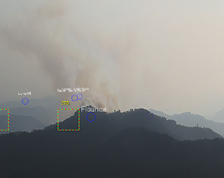
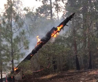
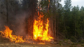
The
#FlounceFire, which is currently the largest, is estimated to be approximately 10 acres, located 2 miles northeast of Lost Creek Lake near Trail. The image of the Flounce Fire below was captured by our detection center earlier this afternoon. Several resources are being dedicated to this fire for an aggressive, initial attack. Please be cautious of
increased fire traffic in the area.
So far, the district has received over a dozen down strikes since 4:45 p.m., and the thunderstorm has not cleared our region yet. We will continue to be vigilant in our firefighting mission.
Additional contract crews are being requested in order to assist in searching for smokes and suppression efforts into the night.
August 1, 2017
Despite the challenging terrain and extreme heat, firefighters stopped and are holding the Long Gulch Fire at 2.5 acres tonight. The fire is 100 percent lined. The fire burning on Bureau of Land Management forestland is roughly two miles north of Bear Camp, west of the Rogue River Trail.
The initial report of smoke came in roughly around 1:00 p.m. Both our
ODF Southwest Oregon District detection cameras, and those of our p
artners north of us, the Douglas Forest Protective Association, picked up a light, wispy column forming near the Josephine-Curry County line. Immediately, aerial recon was dispatched to scout the fire behavior and an exact location for additional resources to respond. Due to the rugged nature of the terrain, aerial resources were determined to be the best source of initial action for the fire. This provided time to ground resources to search for access in the area.

In total, over 50 firefighters, two LATs (Large Air Tankers), one fixed-wing and five helicopters were involved in the direct attack on the Long Gulch Fire. While the conditions were prime for a potentially large wildfire, the aggressive initial attack by both air and ground resources was advantageous in today’s firefight.
As always, we would like to thank our partners for the contnuous cooperation. Today, the
U.S. Forest Service- Rogue River-Siskiyou National Forest assisted us with both air and ground resources that were essential to the success of this mission. We are proud to be a fantastic example of Oregon’s complete and coordinated system.
Tonight, all aircraft our on hold, but ground resources will continue searching for hot spots and mopping up overnight. The cause of the Long Gulch Fire is under investigation.
We are continuing to encourage everyone to know the fire restrictions in your area. Please visit our Facebook page:
ODF Southwest Oregon District, or our website,
www.swofire.com to learn more about what the “extreme” (red) fire danger level means for you and your family while out and about this summer. It’s up to all of us to do our part to prevent
#wildfires.
August 1, 2017
Both the Burnt Peak Fire, located roughly 13 miles northeast of Shady Cove, and the Savage Creek Fire, located off Savage Creek Road near Grants Pass, will both be in extensive mop up throughout the remainder of this week.
The 31-acre Burnt Peak Fire is now 67 percent contained. Firefighters mopped up 200 feet in from the fire’s edge over the past 24 hours. Crews will continue to search for hot spots in the steep terrain until they are certain the entirety of the fire is dead out.
The 3.3-acre Savage Creek Fire is 80 percent contain as of this afternoon. Smoke was visible throughout the day over this fire due to the amount of heat being released during mop up. This means, as firefighters continue to comb through the burned area, crews are turning over timber, debris and other hot spots in order to release any heat stored under the surface fuels.
For additional information on these fire, as well as visuals of what the firefighters have been facing on the ground, please visit our Facebook page: ODF Southwest.
Fire management officials ask that the public continue to use caution and adhere to fire restrictions. Current regulations for lands in Jackson and Josephine Counties protected by the Oregon Department of Forestry Southwest Oregon District can be found at www.swofire.com.
August 1, 2017
Increased fire danger on forestlands protected by the Oregon Department of Forestry’s Southwest Oregon District has made it necessary to increase the fire prevention measures on industrial operations, such as logging sites and other commercial operations. Industrial Fire Precaution Level (IFPL) III (three) takes effect at 12:01 a.m. tomorrow, Wednesday, August 2.
The following are prohibited between 1:00 p.m. – 8:00 p.m.:
- Power saws at loading sites;
- Loading or hauling of any product or material;
- Blasting;
- Welding, cutting, or grinding of metal;
- Any other spark emitting operation not specifically mentioned.
In addition, the following are permitted to operate overnight to the morning, between the hours of 8:00 p.m. and 1:00 p.m., where mechanized equipment capable of constructing fire line is immediately available to quickly reach and effectively attack a fire start:
- Ground-based operations (tractor/skidder, feller-buncher, forwarder, or shovel logging operations);
- Power saws on ground-based operations;
- Rotary head saw feller-bunchers with a continuous Firewatch;
- Non-rotary head saw feller-bunchers;
- Tethered logging – winch-assisted, cable-assisted, traction-assisted, etc. systems, which enable ground-based timber harvesting machines to operate on steep slopes.
This is considered a restricted shutdown and the following activities are not permitted at any time, except as noted:
- Cable yarding systems, except that gravity operated logging systems using non-motorized carriages or approved motorized carriages may operate between 8:00 p.m. and 1:00 p.m., when all blocks and moving lines are suspended at least 10 feet above the ground (except the line between the carriage and the chokers).
For the general public, ODF Southwest’s fire restrictions remain in effect and unchanged with a fire danger level of “extreme” (red). For more information about the Oregon Department of Forestry’s public or industrial fire season restrictions, visit our Facebook page: ODF Southwest Oregon District, or our website www.swofire.com.
###
July 30, 2017
Today, firefighters walked the perimeter of the Burnt Peak Fire allowing for more accurate information to be gathered. Firefighters used GPS points from the ground to determine that the fire is 31 acres as of this afternoon. The fire is 30 percent contained. No evacuation orders have been issued; no structures were ever threatened by this fire.
Since the early hours of this morning, fire crews have been working to strengthen the control line around the perimeter. By the end of today’s day shift, firefighters mopped up 30 feet in from the fire’s edge. Although a quarter-acre spot fire was located southwest of the main body this morning, it was quickly knocked down and will be monitored through the upcoming days.
The Burnt Peak Fire located roughly 13 miles northeast of Shady Cove is burning in timber and debris on steep terrain on private property. The rugged landscape and gusty winds continue to challenge firefighters; however, the continuous coordination between ground and air attack assisted in today’s progress. One fixed-wing aircraft and three helicopters supported the fire today.
Tomorrow, firefighters will continue extensive mop up of the Burnt Peak Fire. With the triple-digit temperatures forecasted this week, crews are working to eliminate chances for flare ups. The fire was first reported Saturday around 6:15 p.m. and its cause is under investigation.
Fire management officials ask that the public continue to use caution and adhere to fire restrictions. Current regulations for lands in Jackson and Josephine Counties protected by the Oregon Department of Forestry Southwest Oregon District can be found at www.swofire.com.
July 30, 2017
At approximately 6:15 p.m., an Oregon Department of Forestry Southwest Oregon District reconnaissance aircraft was searching for a report of smoke in the area just north of Butte Falls. Air attack not only located the Olsen Fire which was knocked down at 1/10thof an acre, but also spotted a small, steady column building roughly 10-15 miles away. Immediately, multiple ODF Southwest engines, dozers, water tenders and two Type 2 helicopters were dispatched to the Burnt Peak Fire.
The initial size-up of the fire from the air was estimated to be 1-3 acres. The fire was quick moving, burning in steep terrain with wind shifts manipulating the direction of growth constantly. An additional Type 1 helicopter and two LATs (Large Air Tankers) were ordered to assist preliminary air operations. From 6:45 p.m. til 9:00 p.m., a total of five runs were made with the air tankers, which is equal to 15,000 gallons of retardant. Dozens of water drops were made collectively by the three helicopters. In order to continue using our air firefighting resources, a TFR (Temporary Flight Restriction) will be in effect beginning tomorrow at 6:00 a.m. For more information regarding the TFR over the Burnt Peak Fire as well as others in effect throughout the region, please visit www.tfr.faa.gov.
While air operations worked on the fire, ground resources were facing accessibility challenges due to steep slopes combined with limited road infrastructure. By the time the first engine engaged with the fire, the size was estimated at 20 acres. Crews worked on attacking the fire as aggressively and directly as possible; however, the wind shifts created a dangerous and difficult fire fight as spotting continued along the ridgeline. Firefighters were able to begin flanking the fire near sundown, but anticipate gusty winds throughout the night.
The Burnt Peak Fire, burning three air miles north of Lost Creek Lake, is estimated to be 60 acres as of 11 p.m. tonight. The cause of the fire is under investigation. There are no structures threatened; no evacuation notices have been issued. The closest structure is roughly three miles southwest of the fire along Elk Creek Road in Trail. There will be heavy fire traffic throughout the area. Please avoid the road, if possible.
Although no evacuation orders are in effect, it is a good time to make sure your family’s evacuation plan is refreshed and ready. To learn more about the state of Oregon’s three level evacuation process and how you can be prepared when wildfire strikes, visit the Rogue Valley Emergency Management page. The fire danger level throughout Jackson and Josephine Counties moves to ‘extreme’ Monday. For a reminder of what public fire restrictions will take effect, visit our Facebook page, ODF Southwest.
July 28, 2017
On Sunday, a grass fire off Interstate 5 and milepost 55 in Grants Pass was quickly knocked down at a half-acre; however, every firefighter on the ground and in the air faced an additional risk when a hobby drone was spotted in the sky.
The powerline-related fire was called in at roughly 4:10 p.m. Sunday, July 23rd. Within minutes, five engines, one water tender and one hand crew from the Oregon Department of Forestry Southwest Oregon District, one engine and one water tender from Rural Metro Fire Josephine County and two engines from Grants Pass Fire arrived on scene and began containing the fire. An ODF Southwest Oregon District, Type 2 helicopter, was dispatched shortly after to assist in the initial attack. Upon arrival, the helicopter was requested to perform a reconnaissance mission along the I-5 corridor in order to guarantee that the fire did not spot or spread to areas that firefighters on the ground could not see. With the water bucket deployed and already in tow, the helicopter headed south along I-5 searching for additional fire starts. The pilot had every intention of returning to the fire after the scouting mission; however, an ODF engine crewman spotted a drone heading toward the active fire scene just moments after the helicopter changed direction. The pilot was immediately contacted, left the area to create distance between himself and the drone, then landed safely at our Grants Pass headquarters. The Federal Aviation Administration (FAA) will be investigating the incident moving forward. ODF Southwest Oregon District would like to encourage anyone who sees a drone over an active fire incident to call 9-1-1.
“It jeopardizes the safety of our pilots, firefighters and the public. We are asking that people help spread this message so a drone interfering with firefighting operations does not happen again,” said ODF Southwest District Forester, Dave Larson.
As unmanned aircraft system (UAS) technology has become increasingly popular, so have run-ins between hobby drones and wildland firefighting agencies, like the Oregon Department of Forestry, that consider it a hindrance. This is the first time aerial operations have been grounded by a drone in the Southwest Oregon District. Thankfully, the pilot, firefighters and the public below were not harmed by the drone intrusion. Many people often forget that a single hobby drone is enough to take down firefighting aircraft.
When drones interfere with firefighting efforts, a wildfire has the potential to grow larger and cause more damage. Every second counts. Not to mention, every time an aircraft is grounded due to drone interference, thousands of dollars are wasted on take-off and landing alone. It is important to note that just because a helicopter is not visible in the sky, or flames are no longer noticeable on the ground, does not mean that fire scene is no longer ‘active.’ Aircraft are often orbiting a wildfire long after flames are knocked down. In addition, resources on the ground and in the air often revisit fire scenes in order to ensure there is no heat radiating from the ground that could potentially spark a new fire. As long as there are boots on the ground, the fire scene remains active.
Recreational drone use on a wildfire is prohibited by the FAA due to amount of risk in regards to human life. According to the FAA, “drone operators who interfere with wildfire suppression efforts are subject to civil penalties of up to $27,500 and possible criminal prosecution.” For further information about drone regulations, visit: www.knowbeforeyoufly.org.
Remember, if you fly, we can’t.
Please join ODF Southwest Oregon District in sharing our message on Facebookand YouTube. Together, we can keep everyone in the air and on the ground safe allowing us to attack and suppress wildfires faster than if we worked alone.
###